NATL: MELISSA - Hurricane - Discussion

Current storms and invests:

Moderators: hurricanetrack, S2k Moderators


The posts in this forum are NOT official forecasts and should not be used as such. They are just the opinion of the poster and may or may not be backed by sound meteorological data. They are NOT endorsed by any professional institution or STORM2K. For official information, please refer to products from the National Hurricane Center and National Weather Service.

Help Support Storm2K
Message
Author
User avatar
sasha_B
Tropical Storm
Tropical Storm
Posts: 221
Age: 24
Joined: Sun Jun 30, 2024 4:32 pm
Location: Charleston, SC

Re: NATL: MELISSA - Hurricane - Discussion

#861 Postby sasha_B » Sun Oct 26, 2025 2:06 am

Up to 110 kts on best track.
13L MELISSA 251026 0600 16.3N 76.1W ATL 110 954


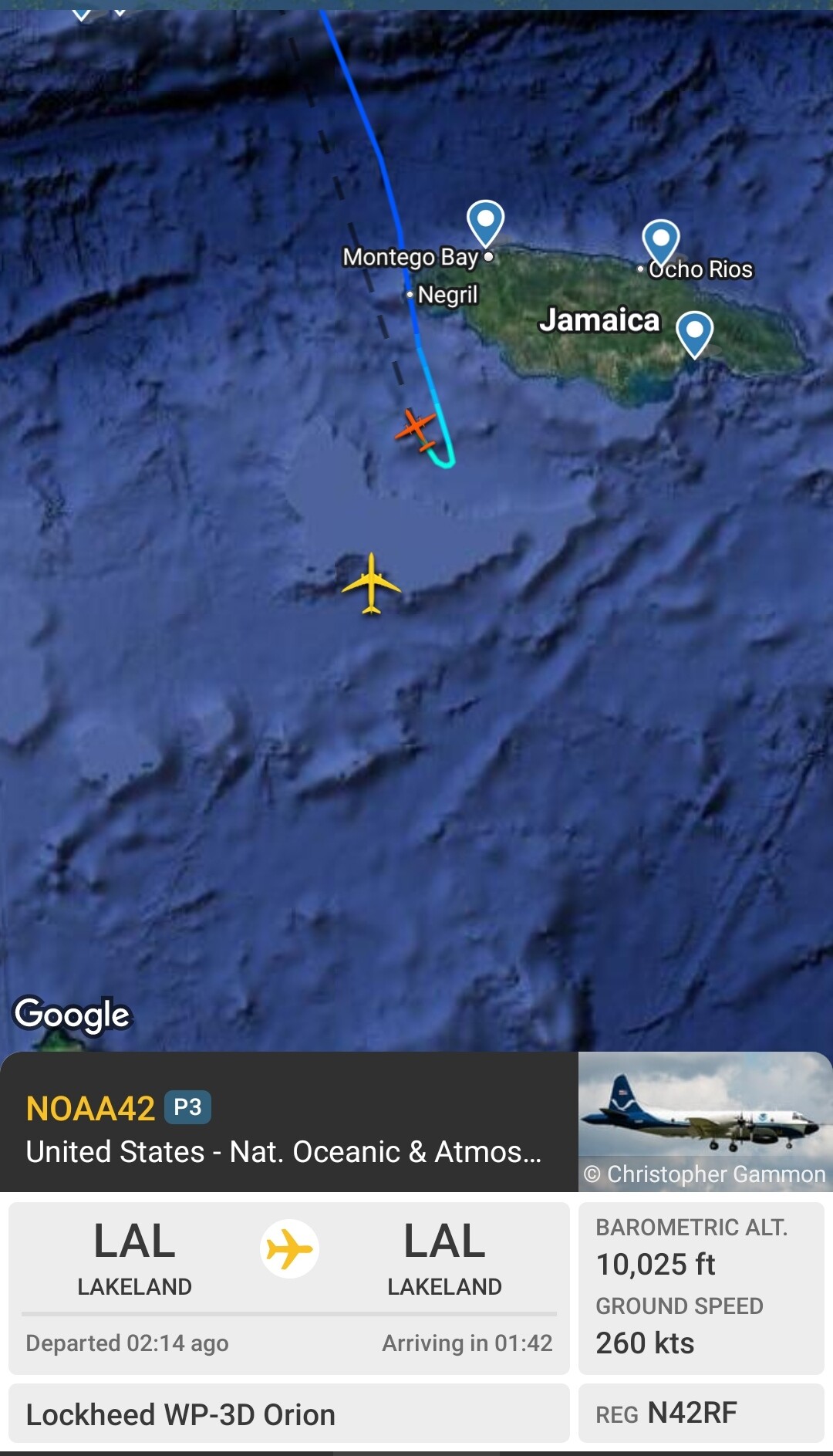
Also, we have a T6.0 fix from NOAA, based on constraints. DT was 6.5.
H. REMARKS...OW EYE SURROUNDED BY CMG AND EMBEDDED IN W RESULTS IN AN E#
OF 6.0 WITH AN EADJ OF 0.5 FOR A DT OF 6.5. THE 6-HOUR AVG GIVES 6.1 SO
THIS DOES NOT JUSTIFY BREAKING CONSTRAINTS AT THIS TIME. THE MET EQUALS
5.0 BASED ON A RAPIDLY DEVELOPING 24-HOUR TREND AND THE PT EQUALS 5.5. THE
FT IS BASED ON CONSTRAINTS DUE TO THE LIMIT OF 1.0 T-NUMBER CHANGE IN
6 HOURS.
2 likes   

dexterlabio
Category 5
Category 5
Posts: 3483
Joined: Sat Oct 24, 2009 11:50 pm

Re: NATL: MELISSA - Hurricane - Discussion

#862 Postby dexterlabio » Sun Oct 26, 2025 2:22 am

Atlantic dropping the biggest bomb of the season in late October.
0 likes   
Personal Forecast Disclaimer:
The posts in this forum are NOT official forecast and should not be used as such. They are just the opinion of the poster and may or may not be backed by sound meteorological data. They are NOT endorsed by any professional institution or storm2k.org. For official information, please refer to the NHC and NWS products.

User avatar
chaser1
S2K Supporter
S2K Supporter
Posts: 5719
Age: 64
Joined: Sat Oct 15, 2005 5:59 pm
Location: Longwood, Fl

Re: NATL: MELISSA - Hurricane - Discussion

#863 Postby chaser1 » Sun Oct 26, 2025 2:33 am

WaveBreaking wrote:Just to show how quickly things went from 0 to 100 (GIF spans from 10/21 to 10/26)

Going to bed now. Hope everyone stays safe in Jamaica.

https://i.imgur.com/0mfOS81.gif


Perhaps even more impressive would be two side-by-side satellite photo's comparing current to 24 hours ago. An amazing transformation :eek:
1 likes   
Andy D

(For official information, please refer to the NHC and NWS products.)

emings
Tropical Low
Tropical Low
Posts: 35
Joined: Mon Jun 18, 2018 3:16 pm

Re: NATL: MELISSA - Hurricane - Discussion

#864 Postby emings » Sun Oct 26, 2025 2:53 am

Wow :eek:


ADVANCED DVORAK TECHNIQUE
ADT-Version 9.1
Tropical Cyclone Intensity Algorithm

----- Current Analysis -----
Date : 26 OCT 2025 Time : 071021 UTC
Lat : 16:19:47 N Lon : 76:07:12 W


CI# /Pressure/ Vmax
5.6 / 954.9mb/104.6kt


Final T# Adj T# Raw T#
5.6 5.7 7.7

Estimated radius of max. wind based on IR : 13 km

Center Temp : +6.1C Cloud Region Temp : -77.4C

Scene Type : EYE
Image
3 likes   
Personal Forecast Disclaimer:
The posts in this forum are NOT official forecast and should not be used as such. They are just the opinion of the poster and may or may not be backed by sound meteorological data. They are NOT endorsed by any professional institution or storm2k.org. For official information, please refer to the NHC and NWS products.

PavelGaborik10
Category 1
Category 1
Posts: 456
Joined: Tue Sep 04, 2018 3:23 pm

Re: NATL: MELISSA - Hurricane - Discussion

#865 Postby PavelGaborik10 » Sun Oct 26, 2025 3:34 am

Absolutely exploding.
1 likes   

User avatar
Hammy
Category 5
Category 5
Posts: 5865
Age: 42
Joined: Fri May 25, 2012 5:25 pm
Contact:

Re: NATL: MELISSA - Hurricane - Discussion

#866 Postby Hammy » Sun Oct 26, 2025 3:46 am

chaser1 wrote:
WaveBreaking wrote:Just to show how quickly things went from 0 to 100 (GIF spans from 10/21 to 10/26)

Going to bed now. Hope everyone stays safe in Jamaica.

https://i.imgur.com/0mfOS81.gif


Perhaps even more impressive would be two side-by-side satellite photo's comparing current to 24 hours ago. An amazing transformation :eek:


Image
2 likes   
The above post is not official and should not be used as such. It is the opinion of the poster and may or may not be backed by sound meteorological data. It is not endorsed by any professional institution or storm2k.org. For official information, please refer to the NHC and NWS products.

User avatar
eastcoastFL
Category 5
Category 5
Posts: 3954
Age: 43
Joined: Thu Apr 12, 2007 12:29 pm
Location: Palm City, FL

Re: NATL: MELISSA - Hurricane - Discussion

#867 Postby eastcoastFL » Sun Oct 26, 2025 3:58 am

The storms have really filled in quickly.

Image
1 likes   
Personal Forecast Disclaimer:
The posts in this forum are NOT official forecast and should not be used as such. They are just the opinion of the poster and may or may not be backed by sound meteorological data. They are NOT endorsed by any professional institution or storm2k.org. For official information, please refer to the NHC and NWS products.

Chemmers
Tropical Storm
Tropical Storm
Posts: 221
Joined: Wed Jul 22, 2020 6:16 am

Re: NATL: MELISSA - Hurricane - Discussion

#868 Postby Chemmers » Sun Oct 26, 2025 4:04 am

I think by the time the recon gets there, we might have a cat 5 on are hands
0 likes   

User avatar
aspen
Category 5
Category 5
Posts: 8964
Joined: Sat Oct 12, 2019 7:10 pm
Location: Connecticut, USA

Re: NATL: MELISSA - Hurricane - Discussion

#869 Postby aspen » Sun Oct 26, 2025 4:10 am

Crazy sight to wake up to this morning. But now it looks like an EWRC or eyewall meld is already starting, based on some developments on the east side of the CDO. Lines up with an occasional outer eyewall on that radar loop.
1 likes   
Irene '11 Sandy '12 Hermine '16 5/15/2018 Derecho Fay '20 Isaias '20 Elsa '21 Henri '21 Ida '21

I am only a meteorology enthusiast who knows a decent amount about tropical cyclones. Look to the professional mets, the NHC, or your local weather office for the best information.

User avatar
Stormgodess
Category 1
Category 1
Posts: 302
Joined: Mon Sep 14, 2020 1:31 am

Re: NATL: MELISSA - Hurricane - Discussion

#870 Postby Stormgodess » Sun Oct 26, 2025 4:15 am

Will we be getting any updated surge prediction maps?
0 likes   

User avatar
GCANE
S2K Supporter
S2K Supporter
Posts: 11890
Joined: Mon Oct 22, 2007 8:03 am

Re: NATL: MELISSA - Hurricane - Discussion

#871 Postby GCANE » Sun Oct 26, 2025 4:35 am

0 likes   

User avatar
GCANE
S2K Supporter
S2K Supporter
Posts: 11890
Joined: Mon Oct 22, 2007 8:03 am

Re: NATL: MELISSA - Hurricane - Discussion

#872 Postby GCANE » Sun Oct 26, 2025 4:41 am

1 likes   

User avatar
GCANE
S2K Supporter
S2K Supporter
Posts: 11890
Joined: Mon Oct 22, 2007 8:03 am

Re: NATL: MELISSA - Hurricane - Discussion

#873 Postby GCANE » Sun Oct 26, 2025 4:51 am

Up to 40" rain on the eastern end of Jamaica

 https://x.com/NHC_Atlantic/status/1982374720411451873

2 likes   

MEANINGLESS_NUMBERS
Category 1
Category 1
Posts: 451
Joined: Mon Nov 02, 2020 1:43 pm

Re: NATL: MELISSA - Hurricane - Discussion

#874 Postby MEANINGLESS_NUMBERS » Sun Oct 26, 2025 4:57 am

GCANE wrote:Up to 40" rain on the eastern end of Jamaica

 https://x.com/NHC_Atlantic/status/1982374720411451873


Forty more inches. It has already been raining for two days.
0 likes   
Emily '87, Felix '95, Gert '99, Fabian '03, Humberto '19, Paulette '20, Teddy '20, Fiona '22, Lee '23, Ernesto '24, Humberto/Imelda '25

User avatar
mrbagyo
Category 5
Category 5
Posts: 3831
Age: 33
Joined: Thu Apr 12, 2012 9:18 am
Location: 14.13N 120.98E
Contact:

Re: NATL: MELISSA - Hurricane - Discussion

#875 Postby mrbagyo » Sun Oct 26, 2025 5:00 am

Convection has fully wrapped on the weaker NE sector again
Kermit is only about 1 hour+ away.

Image
2 likes   
The posts in this forum are NOT official forecast and should not be used as such. They are just the opinion of the poster and may or may not be backed by sound meteorological data. They are NOT endorsed by any professional institution or storm2k.org. For official information, please refer to RSMC, NHC and NWS products.

User avatar
GCANE
S2K Supporter
S2K Supporter
Posts: 11890
Joined: Mon Oct 22, 2007 8:03 am

Re: NATL: MELISSA - Hurricane - Discussion

#876 Postby GCANE » Sun Oct 26, 2025 5:14 am

mrbagyo wrote:Convection has fully wrapped on the weaker NE sector again
Kermit is only about 1 hour+ away.

https://s12.gifyu.com/images/b3neZ.gif


I have never seen vortices on the feeder band like that.
1 likes   

User avatar
Beef Stew
Category 2
Category 2
Posts: 544
Joined: Sat May 30, 2020 11:31 am
Location: South Florida

Re: NATL: MELISSA - Hurricane - Discussion

#877 Postby Beef Stew » Sun Oct 26, 2025 5:24 am

GCANE wrote:
mrbagyo wrote:Convection has fully wrapped on the weaker NE sector again
Kermit is only about 1 hour+ away.

https://s12.gifyu.com/images/b3neZ.gif


I have never seen vortices on the feeder band like that.


Structurally she reminds me quite a lot of Beryl with the massive feeder band and these vortices.
1 likes   

User avatar
mrbagyo
Category 5
Category 5
Posts: 3831
Age: 33
Joined: Thu Apr 12, 2012 9:18 am
Location: 14.13N 120.98E
Contact:

Re: NATL: MELISSA - Hurricane - Discussion

#878 Postby mrbagyo » Sun Oct 26, 2025 5:25 am

Why it appears Kermit's making a UTurn
Image
0 likes   
The posts in this forum are NOT official forecast and should not be used as such. They are just the opinion of the poster and may or may not be backed by sound meteorological data. They are NOT endorsed by any professional institution or storm2k.org. For official information, please refer to RSMC, NHC and NWS products.

User avatar
kevin
Category 5
Category 5
Posts: 2799
Age: 27
Joined: Wed Aug 28, 2019 4:35 am

Re: NATL: MELISSA - Hurricane - Discussion

#879 Postby kevin » Sun Oct 26, 2025 5:27 am

Melissa looks incredible, I think recon is gonna find a very extreme storm.
0 likes   

User avatar
kevin
Category 5
Category 5
Posts: 2799
Age: 27
Joined: Wed Aug 28, 2019 4:35 am

Re: NATL: MELISSA - Hurricane - Discussion

#880 Postby kevin » Sun Oct 26, 2025 5:28 am

mrbagyo wrote:Why it appears Kermit's making a UTurn
https://s12.gifyu.com/images/b3ubq.jpg


Looks like it's travelling south again so maybe it's all good.
0 likes   


Return to “Active Storms/Invests - Atlantic/EastPAC/CentralPAC/MED”

Who is online

Users browsing this forum: cheezyWXguy, TheDreamTraveler and 113 guests