https://ftp.nhc.noaa.gov/atcf/btk/bal902024.dat
ATL: INVEST 90L - Discussion
Moderator: S2k Moderators
ATL: INVEST 90L - Discussion
AL, 90, 2024061112, , BEST, 0, 264N, 847W, 20, 1009, DB, 34, NEQ, 0, 0, 0, 0, 1010, 140, 120, 0, 0, L, 0, , 0, 0, INVEST, S, 0, , 0, 0, 0, 0, genesis-num, 004, SPAWNINVEST, al742024 to al902024,
https://ftp.nhc.noaa.gov/atcf/btk/bal902024.dat
0 likes
- Tampa Bay Hurricane
- Category 5

- Posts: 5596
- Age: 36
- Joined: Fri Jul 22, 2005 7:54 pm
- Location: St. Petersburg, FL
Re: ATL: INVEST 90L - Discussion
Some spiral banding and a surface low attempting to form- fighting lots of shear, breezy in Tampa Bay
1 likes
-
jlauderdal
- S2K Supporter

- Posts: 6902
- Joined: Wed May 19, 2004 5:46 am
- Location: NE Fort Lauderdale
- Contact:
Re: ATL: INVEST 90L - Discussion
Tampa Bay Hurricane wrote:Some spiral banding and a surface low attempting to form- fighting lots of shear, breezy in Tampa Bay
The Gulf is not favorable or even close. We will see what it finds off JAX in a few days. NWS seems to have a good handle on the situation south of the 1-4 corridor. Tomorrow into Thursday should be a kill shot for some people with the flooding. Today, the soil moistened up, and tomorrow, FFG goes way down with saturated ground.
0 likes
- cycloneye
- Admin

- Posts: 140514
- Age: 67
- Joined: Thu Oct 10, 2002 10:54 am
- Location: San Juan, Puerto Rico
Re: ATL: INVEST 90L - Discussion
The biggest concern is the high amounts of rain.


1 likes
Visit the Caribbean-Central America Weather Thread where you can find at first post web cams,radars
and observations from Caribbean basin members Click Here
and observations from Caribbean basin members Click Here
-
Sciencerocks
- Category 5

- Posts: 7752
- Age: 38
- Joined: Thu Jul 06, 2017 1:51 am
-
Sciencerocks
- Category 5

- Posts: 7752
- Age: 38
- Joined: Thu Jul 06, 2017 1:51 am
Re: ATL: INVEST 90L - Discussion
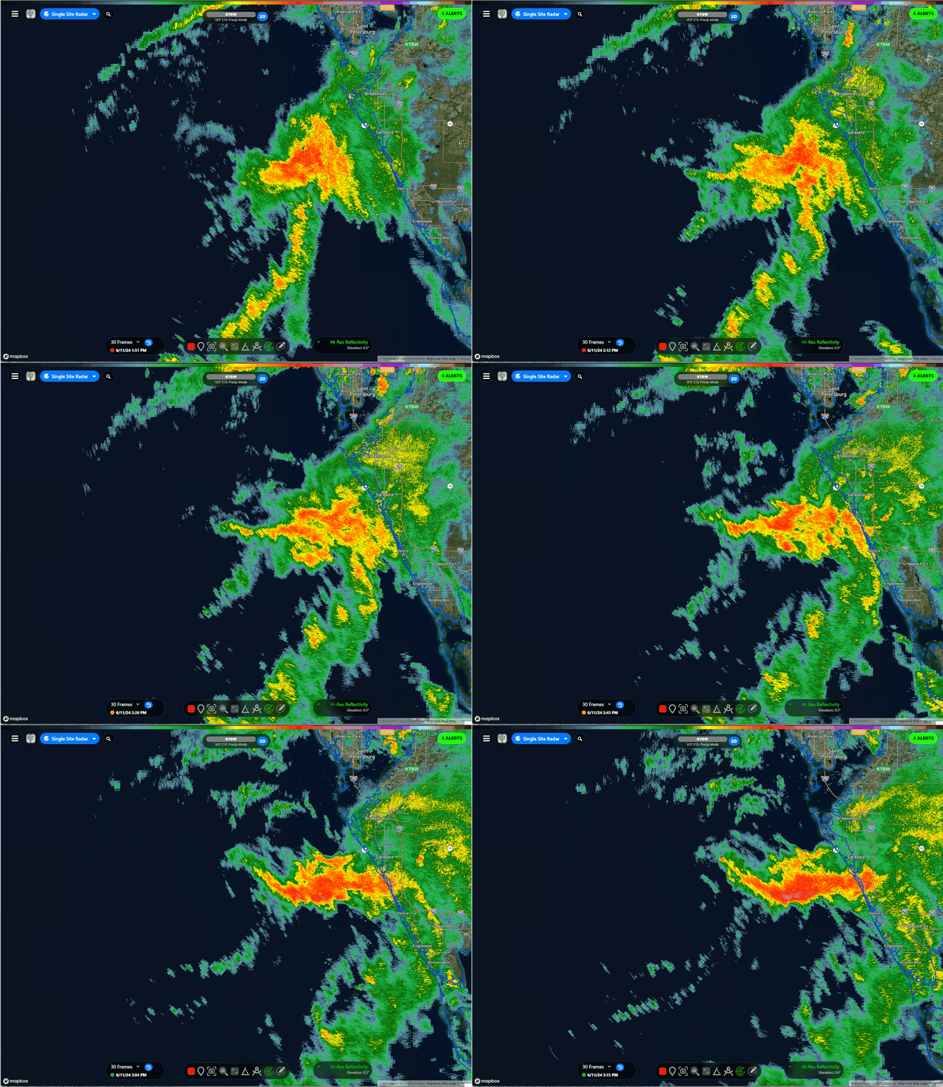
Very heavy rain has developed and persisted at the northern edge of this deep moisture just off of Pasco County where radar estimates of 6" in 3 hours. I'm just about 25 miles SE of this hot zone and I'm still working on my first .1". Predicting rain bombs is a tough game
1 likes
- StPeteMike
- Category 1

- Posts: 394
- Joined: Thu Jun 07, 2018 11:26 pm
Re: ATL: INVEST 90L - Discussion
psyclone wrote:Very heavy rain has developed and persisted at the northern edge of this deep moisture just off of Pasco County where radar estimates of 6" in 3 hours. I'm just about 25 miles SE of this hot zone and I'm still working on my first .1". Predicting rain bombs is a tough game
I was hoping we would get the 6+ rain forecasted a couple days ago but seems like much of the Tampa Bay Area (besides West Pasco it seems) will only get a few inches.
0 likes
The above post is not official and should not be used as such. It is the opinion of the poster and may or may not be backed by sound meteorological data. It is not endorsed by any professional institution or storm2k.org. For official information, please refer to the NHC and NWS products.
- ElectricStorm
- Category 5

- Posts: 4677
- Age: 23
- Joined: Tue Aug 13, 2019 11:23 pm
- Location: Skiatook, OK / Norman, OK
Re: ATL: INVEST 90L - Discussion
First invest of what could be a pretty big year. Doubt this one does much though, maybe an outside chance of a TD.
0 likes
I am in no way a professional. Take what I say with a grain of salt as I could be totally wrong. Please refer to the NHC, NWS, or SPC for official information.
Boomer Sooner!
Boomer Sooner!
- cycloneye
- Admin

- Posts: 140514
- Age: 67
- Joined: Thu Oct 10, 2002 10:54 am
- Location: San Juan, Puerto Rico
Re: ATL: INVEST 90L - Discussion
Tropical Weather Outlook
NWS National Hurricane Center Miami FL
200 PM EDT Tue Jun 11 2024
For the North Atlantic...Caribbean Sea and the Gulf of Mexico:
1. Eastern Gulf of Mexico and Offshore Southeast U.S. (AL90):
A broad area of low pressure over the eastern Gulf of Mexico is
producing a large area of disorganized showers and thunderstorms.
This system is expected to move northeastward across Florida during
the next day or so and move offshore of the U.S. Southeast coast
later this week. Environmental conditions are expected to be
generally unfavorable, although some slow development is possible
when the system is offshore of the U.S. Southeast coast. Regardless
of development, heavy rainfall is already occuring and is expected
to continue across portions of Florida during the next few days.
For more information, see products issued by the Weather Prediction
Center and local National Weather Service Forecast Offices.
* Formation chance through 48 hours...low...10 percent.
* Formation chance through 7 days...low...20 percent.
Weather Prediction Center products can be found at
www.wpc.ncep.noaa.gov and National Weather Service forecast
information can be found at www.weather.gov
Forecaster Kelly
0 likes
Visit the Caribbean-Central America Weather Thread where you can find at first post web cams,radars
and observations from Caribbean basin members Click Here
and observations from Caribbean basin members Click Here
- TheAustinMan
- Category 5

- Posts: 1021
- Age: 24
- Joined: Mon Jul 08, 2013 4:26 pm
- Location: United States
- Contact:
Re: ATL: INVEST 90L - Discussion
While models have depicted the current circulation over the Gulf of Mexico stretching out over Florida and generally not remaining intact, the overall system has done fairly well in fostering a persistent low-level circulation along the trough axis draped over Florida in the face of very strong wind shear. Since the possible system to be is expected to mostly concern the reformation of vorticity off the Southeastern US, it's unclear whether the degree of organization of this system within the Gulf has much of an affect on its developmental chances later on. Radar-observed wind velocities 6-7 kft above the ocean near this center of circulation have routinely exceeded 40 kt. Could be near or over Tampa Bay in 4 or so hours. As far as tropical systems go, it's a few steps removed from 2017's Tropical Storm Emily, which had some broad overall structural similarities when it too developed near the Tampa Bay area.
Source: SSECRealEarth

Source: SSECRealEarth

4 likes
Re: ATL: INVEST 90L - Discussion
We are getting absolutely hosed in Northern Pinellas. Dumpfest McBuckets value meal. It is wonderful! 4" and counting near the Pasco/Pinellas line and it continues to dump
0 likes
- Weatherboy1
- Category 5

- Posts: 1169
- Age: 48
- Joined: Mon Jul 05, 2004 1:50 pm
- Location: Jupiter, FL
Re: ATL: INVEST 90L - Discussion
Getting the “eyewall” storms/rain here in SRQ basically. Good thing it’s just a low pressure!
0 likes
- skyline385
- Category 5

- Posts: 2640
- Age: 34
- Joined: Wed Aug 26, 2020 11:15 pm
- Location: Houston TX
Re: ATL: INVEST 90L - Discussion
TheAustinMan wrote:While models have depicted the current circulation over the Gulf of Mexico stretching out over Florida and generally not remaining intact, the overall system has done fairly well in fostering a persistent low-level circulation along the trough axis draped over Florida in the face of very strong wind shear. Since the possible system to be is expected to mostly concern the reformation of vorticity off the Southeastern US, it's unclear whether the degree of organization of this system within the Gulf has much of an affect on its developmental chances later on. Radar-observed wind velocities 6-7 kft above the ocean near this center of circulation have routinely exceeded 40 kt. Could be near or over Tampa Bay in 4 or so hours. As far as tropical systems go, it's a few steps removed from 2017's Tropical Storm Emily, which had some broad overall structural similarities when it too developed near the Tampa Bay area.
Source: SSECRealEarth
https://i.imgur.com/u5n2ihl.png
The low level circulation very visible on radar now west of Sarasota

1 likes
-
StormPyrate
- Tropical Storm

- Posts: 195
- Joined: Sun May 27, 2018 8:41 pm
- Location: Clearwater, FL
Re: ATL: INVEST 90L - Discussion
psyclone wrote:We are getting absolutely hosed in Northern Pinellas. Dumpfest McBuckets value meal. It is wonderful! 4" and counting near the Pasco/Pinellas line and it continues to dump
It so spotty, here at the Largo / Pinellas line we have had just shy of an inch.
0 likes
St Petersburg Florida
-
StormWeather
- Tropical Low

- Posts: 12
- Joined: Wed Jun 05, 2024 2:34 pm
Re: ATL: INVEST 90L - Discussion
I’m new here, but I have witnessed the past few ATL hurricane seasons (21,22 and 23)
Is it possible that this could form?
Is it possible that this could form?
1 likes
Re: ATL: INVEST 90L - Discussion
I spy a swirl.
Last edited by Zonacane on Tue Jun 11, 2024 6:45 pm, edited 1 time in total.
1 likes
-
jlauderdal
- S2K Supporter

- Posts: 6902
- Joined: Wed May 19, 2004 5:46 am
- Location: NE Fort Lauderdale
- Contact:
Re: RE: Re: ATL: INVEST 90L - Discussion
3.13 for the day, more on the way per radar and the hrrr. Drought buster in progress.StormPyrate wrote:psyclone wrote:We are getting absolutely hosed in Northern Pinellas. Dumpfest McBuckets value meal. It is wonderful! 4" and counting near the Pasco/Pinellas line and it continues to dump
It so spotty, here at the Largo / Pinellas line we have had just shy of an inch.
0 likes
Re: ATL: INVEST 90L - Discussion
Coastal Manatee and Sarasota are getting crushed. Here's to hoping this is the highlight of the tropical season for west central FL. There's a good chance it is considering our geographic advantage and non stop good luck. The sun has returned here in North Pinellas after a 4"+ water dump which immediately soaked in.
0 likes
Who is online
Users browsing this forum: No registered users and 10 guests


