Ex Tropical Depression KAREN: Discussions & Images
Moderator: S2k Moderators
-
wxman57

- Moderator-Pro Met

- Posts: 23172
- Age: 68
- Joined: Sat Jun 21, 2003 8:06 pm
- Location: Houston, TX (southwest)
Re: Tropical Storm KAREN: CEN ATL: Discussions & Images
I suppose we can't discount the Euro solution completely. But that's 10 days out and Karen may have several opportunities to turn out to sea depending on how it holds together over the next week.
0 likes

Re: Tropical Storm KAREN: : Global & BAM Models
I'd give New England and Florida about the same chance of being the final target. If invest 98l takes its time moving out and leaves enough weakness or if Karen stalls and gets picked up by a later trough or if a low develops in the NW caribbean and changes the upper air pattern if if if.
0 likes

Whats more interesting about the Euro is thats not the first time its showed that WSW dig around 192hrs, the 12z yesterday had a very similar movement, though that run was more realisitic IMO in terms of how far north it got before it turned W/WSW. FWIW the GFS also appears to bend back west around the same timeframe.
0 likes
-
jasons2k

- Storm2k Executive

- Posts: 8290
- Age: 52
- Joined: Wed Jul 06, 2005 12:32 pm
- Location: The Woodlands, TX
No we shouldn't completely discount it. Anything can happen and the European has been great this year. But in one sentence you say the models are bending left so the NHC will have to as well. Then in the very next sentence you say "the models are wrong." So which is it? And finally, this is nothing for anyone to get scared about just b/c a 10-day model is showing this. At one time there was a very real threat of Dean coming towards Texas but it was nothing to get "scared" about. Now, if in 9 days from now you are in a Hurricane Watch, then maybe you should be a little scared, but not yet, far from it.
0 likes
-
cycloneye

- Admin
- Posts: 149283
- Age: 69
- Joined: Thu Oct 10, 2002 10:54 am
- Location: San Juan, Puerto Rico
Re: Tropical Storm KAREN: Central ATL: Advisories
080
WTNT42 KNHC 272035
TCDAT2
TROPICAL STORM KAREN DISCUSSION NUMBER 12
NWS TPC/NATIONAL HURRICANE CENTER MIAMI FL AL122007
500 PM EDT THU SEP 27 2007
PERSISTENTLY STRONG SOUTHWESTERLY SHEAR CONTINUES TO AFFECT THE
TROPICAL CYCLONE...DISPLACING THE DEEP CONVECTION FROM THE
CIRCULATION CENTER. ALTHOUGH DVORAK SATELLITE INTENSITY ESTIMATES
FROM TAFB AND SAB HAVE DECREASED TO 45 KT...SOME RECENT DEEP
CONVECTIVE BURSTS NEAR THE CENTER SUGGEST A SLIGHTLY HIGHER
INTENSITY. THEREFORE...THE INITIAL WIND SPEED IS SET TO 50 KT.
THE INTENSITY FORECAST IS RELATIVELY STRAIGHTFORWARD THROUGH DAY
5...INDICATING GRADUAL WEAKENING. HOWEVER...LARGE-SCALE DYNAMICAL
MODELS...SHIPS...AND THE LGEM ARE NOW SUGGESTING THAT THE SHEAR
WILL BEGIN TO WEAKEN AROUND THE 96 TO 120 HR PERIOD WHEN THE
TROPICAL CYCLONE REACHES THE UPPER TROUGH AXIS. CONSEQUENTLY...
SLIGHT INTENSIFICATION IN THE LATTER PART OF THE PERIOD IS
POSSIBLE...ALBEIT NOT INDICATED IN THE OFFICIAL FORECAST AT THIS
TIME.
KAREN IS MOVING AT 305/11...WITH THIS GENERAL MOTION CONTINUING
DURING THE NEXT 2 DAYS OR SO AS KAREN PROPAGATES WITHIN THE
DEEP-LAYERED FLOW ASSOCIATED WITH THE SUBTROPICAL RIDGE TO THE
NORTH. THROUGH THE REMAINING PORTION OF THE FORECAST...THE
DYNAMICAL MODELS ARE AGREEING IN BUILDING THE MID- LEVEL RIDGE MORE
TOWARD THE NORTHWEST OF THE CYCLONE CAUSING KAREN TO TURN MORE
WEST-NORTHWESTWARD. THE OFFICIAL FORECAST IS CLOSE TO THE PREVIOUS
PACKAGE AND IS BASED ON A CONSENSUS OF THE MODELS.
FORECAST POSITIONS AND MAX WINDS
INITIAL 27/2100Z 14.3N 48.5W 50 KT
12HR VT 28/0600Z 15.5N 49.8W 45 KT
24HR VT 28/1800Z 16.8N 51.5W 45 KT
36HR VT 29/0600Z 17.8N 52.8W 45 KT
48HR VT 29/1800Z 18.7N 54.0W 45 KT
72HR VT 30/1800Z 20.5N 55.5W 40 KT
96HR VT 01/1800Z 22.5N 56.5W 40 KT
120HR VT 02/1800Z 24.0N 58.5W 40 KT
$$
FORECASTER ROBERTS/AVILA
0 likes
-
gatorcane

- S2K Supporter

- Posts: 23708
- Age: 48
- Joined: Sun Mar 13, 2005 3:54 pm
- Location: Boca Raton, FL
Indeed look closely at this loop
I already see it trying to move more due West...for sure this thing has stopped gaining signficant lattitude...
I still think a shift west for the NHC for the next advisory
http://www.ssd.noaa.gov/goes/east/tatl/loop-avn.html
I already see it trying to move more due West...for sure this thing has stopped gaining signficant lattitude...
I still think a shift west for the NHC for the next advisory
http://www.ssd.noaa.gov/goes/east/tatl/loop-avn.html
0 likes
-
chris_fit

- Category 5

- Posts: 3261
- Age: 43
- Joined: Wed Sep 10, 2003 11:58 pm
- Location: Tampa Bay Area, FL
Re:
gatorcane wrote:I still think a shift west for the NHC for the next advisory
http://www.ssd.noaa.gov/goes/east/tatl/loop-avn.html
Verified at 5pm. Check out the end of that cone.

0 likes
-
gatorcane
- S2K Supporter
- Posts: 23708
- Age: 48
- Joined: Sun Mar 13, 2005 3:54 pm
- Location: Boca Raton, FL
Re:
jschlitz wrote:No we shouldn't completely discount it. Anything can happen and the European has been great this year. But in one sentence you say the models are bending left so the NHC will have to as well. Then in the very next sentence you say "the models are wrong." So which is it? And finally, this is nothing for anyone to get scared about just b/c a 10-day model is showing this. At one time there was a very real threat of Dean coming towards Texas but it was nothing to get "scared" about. Now, if in 9 days from now you are in a Hurricane Watch, then maybe you should be a little scared, but not yet, far from it.
Indeed 10+ days out is far out that is for sure. But the Euro has been showing this west bend for several runs now and that is signficant. In fact the Euro even calle for a WSW bend at one point.
I already see it trying to move more due West...for sure this thing has stopped gaining signficant lattitude...
I still think a shift west for the NHC for the next advisory
Here is the loop
http://www.ssd.noaa.gov/goes/east/tatl/loop-avn.html
One thing is for sure it is not set in stone this thing is going to miss the US. Given climatology I would say it should but this season has definitely defied it so far.
Last edited by gatorcane on Thu Sep 27, 2007 3:47 pm, edited 1 time in total.
0 likes
-
cycloneye
- Admin
- Posts: 149283
- Age: 69
- Joined: Thu Oct 10, 2002 10:54 am
- Location: San Juan, Puerto Rico
Re: Tropical Storm KAREN: CEN ATL: Discussions & Images
From 5 PM Discussion.
KAREN IS MOVING AT 305/11...WITH THIS GENERAL MOTION CONTINUING
DURING THE NEXT 2 DAYS OR SO AS KAREN PROPAGATES WITHIN THE
DEEP-LAYERED FLOW ASSOCIATED WITH THE SUBTROPICAL RIDGE TO THE
NORTH. THROUGH THE REMAINING PORTION OF THE FORECAST...THE
DYNAMICAL MODELS ARE AGREEING IN BUILDING THE MID- LEVEL RIDGE MORE
TOWARD THE NORTHWEST OF THE CYCLONE CAUSING KAREN TO TURN MORE
WEST-NORTHWESTWARD.
Interesting paragrafh there about the future track.
0 likes
-
gatorcane
- S2K Supporter
- Posts: 23708
- Age: 48
- Joined: Sun Mar 13, 2005 3:54 pm
- Location: Boca Raton, FL
Re: Tropical Storm KAREN: CEN ATL: Discussions & Images
cycloneye wrote:From 5 PM Discussion.
KAREN IS MOVING AT 305/11...WITH THIS GENERAL MOTION CONTINUING
DURING THE NEXT 2 DAYS OR SO AS KAREN PROPAGATES WITHIN THE
DEEP-LAYERED FLOW ASSOCIATED WITH THE SUBTROPICAL RIDGE TO THE
NORTH. THROUGH THE REMAINING PORTION OF THE FORECAST...THE
DYNAMICAL MODELS ARE AGREEING IN BUILDING THE MID- LEVEL RIDGE MORE
TOWARD THE NORTHWEST OF THE CYCLONE CAUSING KAREN TO TURN MORE
WEST-NORTHWESTWARD.
Interesting paragrafh there about the future track.
There is no way it is moving 305 anymore. You can clearly see that from the loop above. I'm not sure what they mean. I say more like 270-290. Its wobbling more West
0 likes
Re: Tropical Storm KAREN: : Global & BAM Models
gatorcane wrote:Euro has a major Karen right down the heart of Miami at 240 hours.
All I have to say is
Models are bending to the left at the end so the NHC track will need to bend to the left...and that may start scaring people
In addition Karen is not even heading NW sot he models are wrong (and have been wrong) so far.
-removed-?????
0 likes
-
curtadams
- S2K Supporter
- Posts: 1122
- Joined: Sun Aug 28, 2005 7:57 pm
- Location: Orange, California
- Contact:
Re: Tropical Storm KAREN: CEN ATL: Discussions & Images
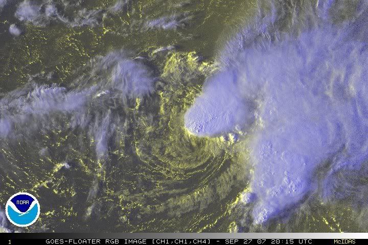
OK, *NOW* Karen is a sheared tropical system. You can see the CDO displaced to the north of the LLC. Earlier today she was subtropical, with no deep convection whatsoever associated with the LLC - like Jerry when he was subtropical.
0 likes
-
Tampa Bay Hurricane

- Category 5
- Posts: 5597
- Age: 38
- Joined: Fri Jul 22, 2005 7:54 pm
- Location: St. Petersburg, FL
Re: Tropical Storm KAREN: CEN ATL: Discussions & Images
I agree Gatorcane about the models, you have been pretty accurate
with karen gatorcane even when I dismissed it as nothing for me
to worry about a couple days ago, I must applaud
you for consistency- The early models have always underestimated
the ridge with systems in this area so far this year with felix
dean--- that ridge is going to build in very strong.
I don't know where this will go but I am pretty sure that
bermuda as well as south florida to the carolinas
will need to watch this closely. Remember how
off the models were with Hurricane Jeanne about this
very Same Time in 2004. Not that the synoptics are the same,
but there is a distinct possible threat to the SE US from this
that has been increasing day by day. Of that I am
very assertive.
0 likes


Re: Tropical Storm KAREN: CEN ATL: Discussions & Images
Does the
Does the fact that this system has become more tropical this afternoon mean it will weaken more, as a subtropical system can maintain its intensity in shear?
curtadams wrote:OK, *NOW* Karen is a sheared tropical system. You can see the CDO displaced to the north of the LLC. Earlier today she was subtropical, with no deep convection whatsoever associated with the LLC - like Jerry when he was subtropical.
Does the fact that this system has become more tropical this afternoon mean it will weaken more, as a subtropical system can maintain its intensity in shear?
0 likes
-
Category 5

- Category 5
- Posts: 10074
- Age: 36
- Joined: Sun Feb 11, 2007 10:00 pm
- Location: New Brunswick, NJ
- Contact:
Re: Tropical Storm KAREN: CEN ATL: Discussions & Images
I hope the bend back doesn't occur.
The best kind of storms are those friendly fish storms that don't bother anybody (except people I disagree with )
)
Latest Quikscat

A nice sunset image
The best kind of storms are those friendly fish storms that don't bother anybody (except people I disagree with
Latest Quikscat
A nice sunset image
Last edited by Category 5 on Thu Sep 27, 2007 4:01 pm, edited 2 times in total.
0 likes
-
bwhorton2007
- Tropical Storm

- Posts: 115
- Joined: Thu Sep 13, 2007 11:17 pm
Re: Tropical Storm KAREN: CEN ATL: Discussions & Images
Is there any chance of karen rebounding into something nasty ?
0 likes
-
Tampa Bay Hurricane
- Category 5
- Posts: 5597
- Age: 38
- Joined: Fri Jul 22, 2005 7:54 pm
- Location: St. Petersburg, FL
Re: Tropical Storm KAREN: CEN ATL: Discussions & Images
Category 5 wrote:I hope the bend back doesn't occur.
The best kind of storms are those friendly fish storms that don't bother anybody (except people I disagree with)
Latest Quikscat image.
Clearly 50+ kt barbs on the NE Side...Karen the Tenacious...
0 likes
-
Tampa Bay Hurricane
- Category 5
- Posts: 5597
- Age: 38
- Joined: Fri Jul 22, 2005 7:54 pm
- Location: St. Petersburg, FL
Re: Tropical Storm KAREN: CEN ATL: Discussions & Images
bwhorton2007 wrote:Is there any chance of karen rebounding into something nasty ?
After the shear subsides in 2 days or so...Euro rebounds it and explodes it to a
cat 3/4.
0 likes
-
Evil Jeremy

- S2K Supporter
- Posts: 5463
- Age: 32
- Joined: Mon Apr 10, 2006 2:10 pm
- Location: Los Angeles, CA
Re: Tropical Storm KAREN: CEN ATL: Discussions & Images
bwhorton2007 wrote:Is there any chance of karen rebounding into something nasty ?
There is always a chance that something can happen in the tropics, but with the latest model runs, I would not be surprised for this to come our way.
0 likes
Who is online
Users browsing this forum: No registered users and 48 guests