Hurricane FELIX: Caribbean-Discussions
Moderator: S2k Moderators
-
Epsilon_Fan

- Category 1

- Posts: 353
- Joined: Fri Jan 13, 2006 1:03 pm
- Location: Charleston, SC
Re: Hurricane FELIX:Caribbean-Discussions & Imagery 11 PM pag 56
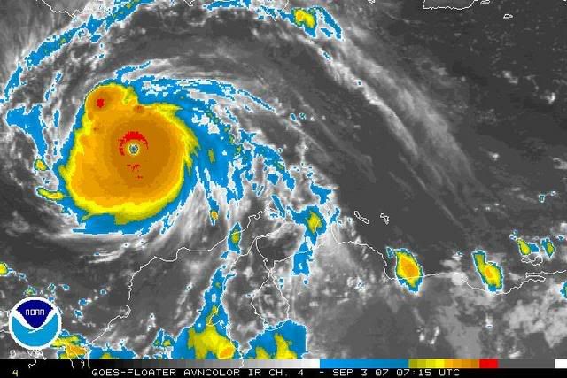
I just saw the latest sat pics... I saw that the banding on the north side was less defined and the CDO was becoming round and symmetric. I immediately came on here and sure enough, the A-word had sprung up already. I think we all like annular canes cuz they look cool 
0 likes
-
miamicanes177
- Category 5

- Posts: 1131
- Joined: Tue Aug 01, 2006 10:53 pm
Re: Hurricane FELIX:Caribbean-Discussions & Imagery 11 PM pag 56
I still say this is headed towards being annular. The latest update from the blackout appears like the banding is dissipating. Pretty soon there will be nothing but a big CDO. Time will tell.miamicanes177 wrote:It is starting to look more annular in my opinion. Notice all the bands have been dieing down and if this continues it will just be one big CDO. No I am not saying it is annular, but it looks to be headed that way.
0 likes
-
miamicanes177
- Category 5
- Posts: 1131
- Joined: Tue Aug 01, 2006 10:53 pm
Re:
wxmann_91 wrote:It's not annular guys. Eye is too small.
Convection though looks like it has continued to wane.
ok well where did all of its rainbands go then? This is most certainly very near an annular hurricane in my opinion. No ewrc in sight and almost nothing but a big CDO.
0 likes
-
miamicanes177
- Category 5
- Posts: 1131
- Joined: Tue Aug 01, 2006 10:53 pm
Re: Hurricane FELIX:Caribbean-Discussions & Imagery 11 PM pag 56

Annular Hurricane Felix? You be the judge...I think it might be
0 likes
-
Coredesat
-
wxmann_91

- Category 5
- Posts: 8013
- Age: 34
- Joined: Fri Jul 15, 2005 2:49 pm
- Location: Southern California
- Contact:
Re: Re:
miamicanes177 wrote:wxmann_91 wrote:It's not annular guys. Eye is too small.
Convection though looks like it has continued to wane.
ok well where did all of its rainbands go then? This is most certainly very near an annular hurricane in my opinion. No ewrc in sight and almost nothing but a big CDO.
Sats can lie. Microwave data usually doesn't.
http://cimss.ssec.wisc.edu/tropic/real- ... hr_04.html
Note the outer eyewall beginning to develop.
There is definitely enough instability in the Caribbean to form an outer eyewall or even outer rainbands, thus, an annular hurricane is almost impossible to achieve in that area.
Annular is definitely overused. When you see a storm in a marginal thermodynamic environment, a rather large eye, and no outer rainbands or affinity for development of an outer eyewall, then call it annular.
0 likes
-
Texashawk

- Category 2

- Posts: 579
- Joined: Tue Aug 14, 2007 1:50 am
- Location: Missouri City, TX (Houston)
Re: Hurricane FELIX:Caribbean-Discussions & Imagery 11 PM pag 56
Since I'm not sure that everybody on the boards is versed in annular hurricanes, here's a primer (courtesy of The Free Dictionary)
An annular hurricane is a tropical cyclone in the Atlantic or Eastern Pacific oceans that features a large, symmetric eye surrounded by a thick ring of intense convection. This type of storm is not prone to the fluctuations in intensity associated with eyewall replacement cycles, unlike typical intense tropical cyclones. Forecasters have difficulty predicting the behavior of annular hurricanes; they are a recently recognized phenomenon, and as such, little is known about their tendencies. Because of this, they can be more dangerous than typical hurricanes. CharacteristicsAnnular hurricanes are axisymmetric — symmetric along every radial axis, i.e. very circular in appearance. They lack the spiralform rainbands which are characteristic of typical tropical cyclones. After reaching peak intensity, they weaken much more slowly than non-annular storms of similar intensity. However, most annular hurricanes have annular characteristics for only a portion of their lifetimes.
While hurricanes retain annular characteristics, they also seem to be less affected by diurnal, or daily variations. Most annular hurricanes have peak intensities of greater than 85 knots (98 mph, 157 km/h) and more than 85% of their theoretical maximum potential intensity.
Annular hurricanes maintain their intensities longer than usual after their peaks. Statistics show that forecasters significantly overestimate the lessening of wind velocities in annular hurricanes. In terms of the Dvorak technique, annular hurricanes weaken very slowly after their peak (on average, less than 0.5 T after one day from their peak intensities).
Annular hurricanes are very rare. Few storms meet all of the criteria, although many strong storms resemble annular hurricanes in some criteria. Fewer than 1% of Atlantic tropical cyclones encounter all of the environmental conditions associated with annular hurricanes. In the Eastern Pacific, such conditions are more common, but still very unusual — 3% of Pacific tropical cyclones encounter them.[1] FormationResearch into the characteristics and formation of annular hurricanes is still in its infancy. First classified and categorized in 2002, little is known about how they form, or why some are able to maintain their intensity in hostile conditions.
What meteorologists do know is that a normal hurricane, after undergoing an eyewall replacement cycle, fails to re-establish the standard hurricane appearance. The new eyewall thickens, and rainbands dissipate, and the hurricane takes on an annular structure. As compared to the formation of normal hurricanes, this happens under weaker wind shear and, surprisingly, cooler sea surface temperatures.
Some of the conditions associated with annular hurricanes are:
An intensity 85% or greater from their theoretical maximum potential intensity,
Weak wind shear from the east or southeast,
A cold east wind at a high altitude (the 200 mbar pressure level),
Near-constant sea surface temperatures between 25.4 °C and 28.5 °C, and
Lack of relative eddy flux convergence at the 200 mbar pressure level, relative to the storm.[1]
Notable annular hurricanes
Hurricane Daniel of the 2006 Pacific hurricane season.
Hurricane Luis of the 1995 Atlantic hurricane season, and Hurricane Edouard of 1996 may have been annular hurricanes. Hurricane Epsilon of the 2005 Atlantic Hurricane Season had a similar structure to an annular hurricane, which partially explains the storm's longevity in the face of unfavorable conditions. Powerful Hurricane Isabel from 2003 also generated an annular hurricane structure around the time of its peak intensity.
2006's Hurricane Daniel in the eastern Pacific (image shown at the above at the right) exhibited annular hurricane features with a large, well defined eye and was described as such by the United States' National Hurricane Center. Hurricane Daniel was able to retain Category 4 intensity for a lengthy period of time, and in parts of the Eastern Pacific basin which at the time were unfavorable for such sustained intensity.
0 likes
-
Epsilon_Fan
- Category 1
- Posts: 353
- Joined: Fri Jan 13, 2006 1:03 pm
- Location: Charleston, SC
Re: Hurricane FELIX:Caribbean-Discussions & Imagery 11 PM pag 56
Yeah, I remember Epsilon, Isabel, Daniel, and Monica (Australia) were the only annulars in the last 5 years.
0 likes
-
wxmann_91
- Category 5
- Posts: 8013
- Age: 34
- Joined: Fri Jul 15, 2005 2:49 pm
- Location: Southern California
- Contact:
Re: Hurricane FELIX:Caribbean-Discussions & Imagery 11 PM pag 56
Epsilon_Fan wrote:Yeah, I remember Epsilon, Isabel, Daniel, and Monica (Australia) were the only annulars in the last 5 years.
Monica was not annular either.
0 likes

Re: Hurricane FELIX:Caribbean-Discussions & Imagery 11 PM pag 56
One could mistake it for being such. Look at how beautiful it was:

0 likes

Re: Hurricane FELIX:Caribbean-Discussions & Imagery 11 PM pag 56
Epsilon_Fan wrote:Yeah, I remember Epsilon, Isabel, Daniel, and Monica (Australia) were the only annulars in the last 5 years.
You are forgetting Hurricane Flossie from the Epac of this year.
0 likes

-
wxmann_91
- Category 5
- Posts: 8013
- Age: 34
- Joined: Fri Jul 15, 2005 2:49 pm
- Location: Southern California
- Contact:
Re:
RL3AO wrote:Annular hurricanes form over cooler waters, not boiling waters.
Yes. And I forgot two other big factors...
1) degree of subsidence surrounding a cyclone
2) any major outflow channels
We need 1), and the lack of 2), for an annular hurricane. Again, Felix fails the test.
0 likes
-
wxmann_91
- Category 5
- Posts: 8013
- Age: 34
- Joined: Fri Jul 15, 2005 2:49 pm
- Location: Southern California
- Contact:
Re: Hurricane FELIX:Caribbean-Discussions & Imagery 11 PM pag 56
RattleMan wrote:One could mistake it for being such. Look at how beautiful it was:
Sats lie; radars and microwave rarely do.
While one can mistake it for one with IR sats, one cannot mistake it for one with radar.

0 likes
-
Epsilon_Fan
- Category 1
- Posts: 353
- Joined: Fri Jan 13, 2006 1:03 pm
- Location: Charleston, SC
Re: Hurricane FELIX:Caribbean-Discussions & Imagery 11 PM pag 56
my bad... but Monica was one of the most impressive canes I've seen in the Pac... Ioke was pretty damn impressive too.
0 likes
-
Roswell_Atup
- Tropical Low

- Posts: 21
- Joined: Sat Sep 01, 2007 11:57 am
Re: Hurricane FELIX:Caribbean-Discussions & Imagery 11 PM pag 56
The name Felix has been used 4 times already and all became hurricanes....
and 3 became major hurricanes...
1995 Cat. 4 Felix
2001 Cat. 3 Felix
2007 Cat. 5 Felix
and 3 became major hurricanes...
1995 Cat. 4 Felix
2001 Cat. 3 Felix
2007 Cat. 5 Felix
0 likes
-
philnyc
- S2K Supporter

- Posts: 313
- Joined: Thu Jun 07, 2007 1:14 am
- Location: Brooklyn, New York City, New York
- Contact:
Re:
Its convection is waning at the moment. Part of this has to be from a loss of symmetry. The added area of convection in the right front quadrant is clearly adding some imbalance to the perfect circular flow it had before. This is probably temporary.
Also, as wxmann_91 pointed out, it is getting ready for an EWRC. It is becoming more apparent now. And it was overdue.
Felix will undoubtedly enlarge now, and though it has has probably lost a little strength, will probably re-strengthen more after the enlargement.
Also, as wxmann_91 pointed out, it is getting ready for an EWRC. It is becoming more apparent now. And it was overdue.
Felix will undoubtedly enlarge now, and though it has has probably lost a little strength, will probably re-strengthen more after the enlargement.
Last edited by philnyc on Mon Sep 03, 2007 3:14 am, edited 1 time in total.
0 likes
-
TheEuropean

- Professional-Met

- Posts: 1797
- Age: 60
- Joined: Tue Sep 20, 2005 3:17 pm
- Location: Voerde, Germany
- Contact:
Who is online
Users browsing this forum: No registered users and 65 guests