Invest 98L,Central Atlantic

Moderator: S2k Moderators

Message
Author
Weatherfreak000

Re:

#121 Postby Weatherfreak000 » Sat Sep 01, 2007 2:55 pm

RL3AO wrote:We are just getting started with mid-season.


I was referring to the nicely developing systems out there currently, the multitude of invests supports this.

Coupled with a La Nina, I just can't see why we won't be seeing 6-8 named storms after 98L this year.

The possibility definitely seems valid.
0 likes   

User avatar
bvigal
S2K Supporter
S2K Supporter
Posts: 2276
Joined: Sun Jul 24, 2005 8:49 am
Location: British Virgin Islands
Contact:

Re: Re:

#122 Postby bvigal » Sat Sep 01, 2007 2:55 pm

ok, all the talk here recently about the homepage being updated, where are the models and images for 98L... just asking...

3day week_end on the Beach LOL

You doin' invests, you got a tiger by the tail now, Chad!! ...plan to catch your next good night's sleep in October! LOL, hang in!
0 likes   

User avatar
windstorm99
S2K Supporter
S2K Supporter
Posts: 1578
Age: 47
Joined: Sat May 26, 2007 8:10 am
Location: Miami, Florida
Contact:

Re: Invest 98L,Central Atlantic-Discussions-Analysis & Imagery

#123 Postby windstorm99 » Sat Sep 01, 2007 3:09 pm

98L is feeling about 20kts of windshear right now which might be holding it back a tad.

Image
0 likes   

User avatar
Tampa Bay Hurricane
Category 5
Category 5
Posts: 5597
Age: 37
Joined: Fri Jul 22, 2005 7:54 pm
Location: St. Petersburg, FL

Re: Invest 98L,Central Atlantic-Discussions-Analysis & Imagery

#124 Postby Tampa Bay Hurricane » Sat Sep 01, 2007 3:12 pm

If 98L does decide to chug through the Caribbean, would there possibly
be a trough or should the high keep it south? It's too early
to tell, but does anyone have any ideas about this?
0 likes   

User avatar
canegrl04
Category 5
Category 5
Posts: 2486
Joined: Thu Aug 26, 2004 5:37 pm
Location: Texas

Re: Invest 98L,Central Atlantic-Discussions-Analysis & Imagery

#125 Postby canegrl04 » Sat Sep 01, 2007 3:18 pm

windstorm99 wrote:Models at this point aren't showing to much of a northward trend to them...Mostly want to bring into guess what the caribbean once again. Its somewhat rare for a system at this latitude to make it in the caribbean.

Image


,the models are not going to stay where they are now.We may see a more northward trend in the next 48 hours.If not,this is going to be another Central America event
0 likes   

User avatar
windstorm99
S2K Supporter
S2K Supporter
Posts: 1578
Age: 47
Joined: Sat May 26, 2007 8:10 am
Location: Miami, Florida
Contact:

Re: Invest 98L,Central Atlantic-Discussions-Analysis & Imagery

#126 Postby windstorm99 » Sat Sep 01, 2007 3:21 pm

The way the pattern has been the past couple of weeks it could very well be another central america problem.
0 likes   

User avatar
Buck
S2K Supporter
S2K Supporter
Posts: 1173
Joined: Fri Sep 10, 2004 12:04 pm
Location: Atlanta, GA

#127 Postby Buck » Sat Sep 01, 2007 3:23 pm

Will how fast this intensifies affect this one's path very much? That's a key factor with some storms whereas some storms are gonna go where they go reguardless of how strong they are.
0 likes   

User avatar
cycloneye
Admin
Admin
Posts: 145277
Age: 68
Joined: Thu Oct 10, 2002 10:54 am
Location: San Juan, Puerto Rico

Re: Invest 98L,Central Atlantic-Discussions-Analysis & Imagery

#128 Postby cycloneye » Sat Sep 01, 2007 3:24 pm

windstorm99 wrote:98L is feeling about 20kts of windshear right now which might be holding it back a tad.

Image


You might want to put the red symbol a little bit to the left.

:darrow: :darrow:

NRL Visible pic
0 likes   

User avatar
Tampa Bay Hurricane
Category 5
Category 5
Posts: 5597
Age: 37
Joined: Fri Jul 22, 2005 7:54 pm
Location: St. Petersburg, FL

Re: Invest 98L,Central Atlantic-Discussions-Analysis & Imagery

#129 Postby Tampa Bay Hurricane » Sat Sep 01, 2007 3:26 pm

windstorm99 wrote:The way the pattern has been the past couple of weeks it could very well be another central america problem.


That would be just horrible for them. It seems mother
nature Devastates an area each year
2004- Florida
2005- central gulf coast/west gulf coast
2007- Central America (so far)- Category 5 landfall
0 likes   

User avatar
windstorm99
S2K Supporter
S2K Supporter
Posts: 1578
Age: 47
Joined: Sat May 26, 2007 8:10 am
Location: Miami, Florida
Contact:

Re: Invest 98L,Central Atlantic-Discussions-Analysis & Imagery

#130 Postby windstorm99 » Sat Sep 01, 2007 3:28 pm

Luis that was not me that symbol was put by CIMSS website....
0 likes   

User avatar
cycloneye
Admin
Admin
Posts: 145277
Age: 68
Joined: Thu Oct 10, 2002 10:54 am
Location: San Juan, Puerto Rico

Re: Invest 98L,Central Atlantic-Discussions-Analysis & Imagery

#131 Postby cycloneye » Sat Sep 01, 2007 3:29 pm

windstorm99 wrote:Luis that was not me that symbol was put by CIMSS website....


Oh ok.Well they put it wrong. :)
0 likes   

RL3AO
Moderator-Pro Met
Moderator-Pro Met
Posts: 16308
Joined: Thu Jun 14, 2007 10:03 pm
Location: NC

Re: Invest 98L,Central Atlantic-Discussions-Analysis & Imagery

#132 Postby RL3AO » Sat Sep 01, 2007 3:29 pm

Tampa Bay Hurricane wrote:
windstorm99 wrote:The way the pattern has been the past couple of weeks it could very well be another central america problem.


That would be just horrible for them. It seems mother
nature Devastates an area each year
2004- Florida
2005- central gulf coast/west gulf coast
2007- Central America (so far)- Category 5 landfall


Same thing in the WPac. The Philippines last year and Japan in 2005.
0 likes   

MiamiensisWx

Re: Invest 98L,Central Atlantic-Discussions-Analysis & Imagery

#133 Postby MiamiensisWx » Sat Sep 01, 2007 3:39 pm

There's a definite low-level circulation. It's partially exposed and elongated, but it has become better defined over the past few hours:

Latest GOES visible shot

Although it is still early, I think it should be monitored (more than Felix) as a possible threat to the United States. Personally, I think this system could develop when it approaches the Caribbean, and it could (emphasis added) find a weakness in the H7 (low to mid-level) environment. Some model guidance leaves a slight weakness off the Southeast coast at ~72 hours, and this system's fast forward motion would bring it closer to the islands within four days. Additionally, the "cusp" is well defined - it is really fighting the easterly shear.

Tampa Bay Hurricane wrote:That would be just horrible for them. It seems mother
nature Devastates an area each year
2004- Florida
2005- central gulf coast/west gulf coast

2007- Central America (so far)- Category 5 landfall

Don't forget SC and NC, in addition to the Caribbean. They were hit hard in 2004: look at Ivan, Gaston, Charley, and Jeanne. That final storm killed more than 3,000 in Haiti. Additionally, we (FL) were hit multiple times in 2005 (Dennis, Katrina, Rita, and Wilma). Ophelia affected the Carolinas in 2005. Essentially every coastal region was affected in two seasons.
0 likes   

tolakram
Admin
Admin
Posts: 20009
Age: 62
Joined: Sun Aug 27, 2006 8:23 pm
Location: Florence, KY (name is Mark)

Re: Invest 98L,Central Atlantic-Discussions-Analysis & Imagery

#134 Postby tolakram » Sat Sep 01, 2007 3:41 pm

The convection is out in front of the center and the shear is 20 from the east, so doesn't that make the net shear < 10?
0 likes   

User avatar
HURAKAN
Professional-Met
Professional-Met
Posts: 46086
Age: 38
Joined: Thu May 20, 2004 4:34 pm
Location: Key West, FL
Contact:

#135 Postby HURAKAN » Sat Sep 01, 2007 3:42 pm

By tomorrow's DMAX 98L should be in a lighter environment and we could see it get very close to TD status.
0 likes   

User avatar
canegrl04
Category 5
Category 5
Posts: 2486
Joined: Thu Aug 26, 2004 5:37 pm
Location: Texas

Re: Invest 98L,Central Atlantic-Discussions-Analysis & Imagery

#136 Postby canegrl04 » Sat Sep 01, 2007 3:46 pm

Out of all those models depicted,the GFDL and NHC have more reliability than the others.They are showing a path that would eventually take it into the GOM
0 likes   

User avatar
hial2
S2K Supporter
S2K Supporter
Posts: 809
Joined: Fri Oct 10, 2003 9:20 pm
Location: Indian trail N.C.

Re: Invest 98L,Central Atlantic-Discussions-Analysis & Imagery

#137 Postby hial2 » Sat Sep 01, 2007 4:12 pm

canegrl04 wrote:Out of all those models depicted,the GFDL and NHC have more reliability than the others.They are showing a path that would eventually take it into the GOM


Considering that its just an invest, all the models are basically worthless especially 1 week + out..
0 likes   

Brent
S2K Supporter
S2K Supporter
Posts: 38087
Age: 36
Joined: Sun May 16, 2004 10:30 pm
Location: Tulsa Oklahoma
Contact:

Re: Invest 98L,Central Atlantic-Discussions-Analysis & Imagery

#138 Postby Brent » Sat Sep 01, 2007 4:19 pm

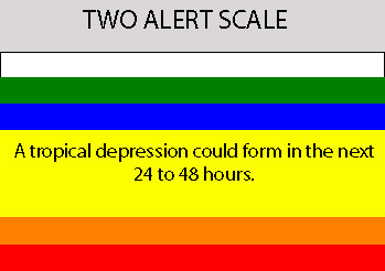
5:30pm TWO:

A STRONG TROPICAL WAVE LOCATED ABOUT MIDWAY BETWEEN AFRICA AND THE
LESSER ANTILLES IS MOVING WESTWARD AT 15 TO 20 MPH. THE ASSOCIATED
SHOWER ACTIVITY HAS INCREASED THIS AFTERNOON...AND THE SYSTEM COULD
BECOME A TROPICAL DEPRESSION DURING THE NEXT DAY OR TWO.
0 likes   

User avatar
HURAKAN
Professional-Met
Professional-Met
Posts: 46086
Age: 38
Joined: Thu May 20, 2004 4:34 pm
Location: Key West, FL
Contact:

#139 Postby HURAKAN » Sat Sep 01, 2007 4:20 pm

Gabrielle is knocking on the door.
0 likes   

RL3AO
Moderator-Pro Met
Moderator-Pro Met
Posts: 16308
Joined: Thu Jun 14, 2007 10:03 pm
Location: NC

#140 Postby RL3AO » Sat Sep 01, 2007 4:23 pm

Image
0 likes   


Return to “2007”

Who is online

Users browsing this forum: No registered users and 3 guests