
Enough.
This is what moderators are for. We don't need two pages of chatter about an inappropriate post.
Get back on topic.
CAT 5 Hurricane Dean - Archived threads
Moderator: S2k Moderators


-
vacanechaser

- Category 5

- Posts: 1461
- Joined: Wed Dec 03, 2003 9:34 pm
- Location: Portsmouth, Va
- Contact:
cycloneye, i guess you had to change your shorts after seeing that 920! 
hopefully that will not happen, or at least if it is coming not that strong...
Jesse V. Bass III
http://www.vastormphoto.com
Hurricane Intercept Research Team
hopefully that will not happen, or at least if it is coming not that strong...
Jesse V. Bass III
http://www.vastormphoto.com
Hurricane Intercept Research Team
0 likes
-
DESTRUCTION5

- Category 5
- Posts: 4430
- Age: 44
- Joined: Wed Sep 03, 2003 11:25 am
- Location: Stuart, FL
-
Wx_Warrior
- Category 5
- Posts: 2718
- Joined: Thu Aug 03, 2006 3:58 pm
- Location: Beaumont, TX
Re: T Storm Dean - Global Models=12z GFS starts at 11:30 AM EDT
DESTRUCT...Guess we have a gate malfunction...No daily-double at Del Mar!!!
0 likes
Re: Tropical Storm Dean (pg.28) - Discussions, Analysis and Sats
skysummit wrote:jason0509 wrote:Some good news for all:
1. Shear still taking a toll on this system.
2. Looking at satelite, cloud tops are warming.
HUH? A nice CDO has developed directly over the LLC. It's still being affected by shear right now, however, that'll be changing over the next 24 - 48 hours.
Cloud tops looked to be warming a bit to me. I didn't see the dark brown contours.....but rather light brown...This is indicative of warming cloud tops usually.
And shear forecasts are notoriously unreliable. We'll see what pans out. Of course, it was just classified so it's obviously doing OK but it's still a weak system in it's formative stages.
0 likes
-
Ivanhater

- Storm2k Moderator

- Posts: 11221
- Age: 39
- Joined: Fri Jul 01, 2005 8:25 am
- Location: Pensacola
Re: Tropical Storm Dean (pg.28) - Discussions, Analysis and Sats
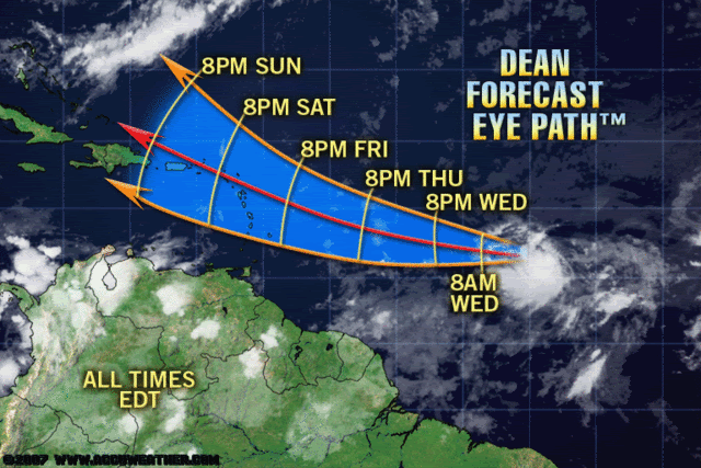
FWIW...Accuweather track...reminds me of a George like track...

0 likes
-
KFDM Meteorologist

- Professional-Met

- Posts: 1314
- Joined: Tue May 16, 2006 9:52 pm
- Location: Upper Texas Coast/Orange County
-
Brent
- S2K Supporter

- Posts: 38730
- Age: 37
- Joined: Sun May 16, 2004 10:30 pm
- Location: Tulsa Oklahoma
- Contact:
Re: Tropical Storm Dean (pg.28) - Discussions, Analysis and Sats
I don't see it weakening at all. There's a nice ball of convection over the center.
0 likes
-
cyclonic chronic
-
CourierPR

- Category 5
- Posts: 1336
- Age: 72
- Joined: Tue Aug 31, 2004 7:53 pm
- Location: Pompano Beach, Florida
Re: Tropical Storm Dean (pg.28) - Discussions, Analysis and Sats
Ivanhater, that actually looks very much like the NHC forecast track. 
0 likes
-
Extremecane
- Tropical Depression

- Posts: 70
- Joined: Sat Aug 11, 2007 1:22 pm
Re: T Storm Dean - Global Models=12z GFS starts at 11:30 AM EDT
Nam starting to get into range :

0 likes

Re: Tropical Storm Dean (pg.28) - Discussions, Analysis and Sats
Still ingesting dry air from the ridge above it. This will change when it hits the warmer waters after 50W.
That track is right over BVIgal.
That track is right over BVIgal.
Last edited by Sanibel on Tue Aug 14, 2007 10:48 am, edited 1 time in total.
0 likes
-
dolebot_Broward_NW
- Category 2

- Posts: 529
- Joined: Fri Sep 10, 2004 6:38 am
Re: Tropical Storm Dean (pg.28) - Discussions, Analysis and Sats
As for the rest I'm really surprised that the new model is so aggressive with Dean intensity wise. Wouldn't a storm that ramps up quickly be more inclined to move poleward?
I think there would have to be something to move it poleward. Weather systems don't come with propulsion, they don't move themselves. The trend towards larger systems moving poleward is due to the Coriolis effect if I'm not mistaken. In this case I don't think the storm is close to large enough yet. Also a large high is moving it to the west - WSW atm. The only break in that is at the western periphery of that high, and the question is whether it will build back towards the EC USA or maintain that weakness as Dean approaches.
http://en.wikipedia.org/wiki/Coriolis_effect
0 likes
-
skysummit

- S2K Supporter
- Posts: 5305
- Age: 50
- Joined: Tue Aug 31, 2004 11:09 pm
- Location: Ponchatoula, LA
- Contact:
Re: Tropical Storm Dean (pg.28) - Discussions, Analysis and Sats
jason0509 wrote:Cloud tops looked to be warming a bit to me. I didn't see the dark brown contours.....but rather light brown...This is indicative of warming cloud tops usually.
And shear forecasts are notoriously unreliable. We'll see what pans out. Of course, it was just classified so it's obviously doing OK but it's still a weak system in it's formative stages.
True...however, I'm not looking at shear forecasts. I'm looking at what's really happening. Shear is affecting it right now, hence the "flattened" look on the northeast side, but this will only continue for another 24 - 48 hours. Cloud tops have warmed a bit along the periphery, but have deepened right over the LLC. Yea, formative stages, but slowly condensing and organizing. Watch out when it crosses 50w.
0 likes
-
Ivanhater
- Storm2k Moderator
- Posts: 11221
- Age: 39
- Joined: Fri Jul 01, 2005 8:25 am
- Location: Pensacola
Re: Tropical Storm Dean (pg.28) - Discussions, Analysis and Sats
CourierPR wrote:Ivanhater, that actually looks very much like the NHC forecast track.
Lol I know, not so much of a curvature though
0 likes
-
KFDM Meteorologist
- Professional-Met
- Posts: 1314
- Joined: Tue May 16, 2006 9:52 pm
- Location: Upper Texas Coast/Orange County
Re: Tropical Storm Dean (pg.28) - Discussions, Analysis and Sats
weatherguru18 wrote:
Now if I lived in the islands or Puerto Rico, now is not the time to panic. Most of the islanders (I think) have storm shutters that can automatically lower during a storm. This thing is still days away. I'm not so sure that this will feel the weakness of a troph. It's far to the south, even more so than first thought, and is farther west than anticipated. Again, it's all about the timeing. I have a gut feeling that this thing may buzz right by Puerto Rico (north or south). The next 24 hrs are critical. Afterall, your "asking" a hurricane to hit a point over a thousand miles away.
This is not true. I don't know what makes you believe that most Puerto Ricans have automatic storm shutters. Many Puerto Ricans have storm shutters, but that is besides the point.
The Puerto Rican economy is going through some hard times as we speak, and no one wants to go through a hurricane. The last thing this island needs is a hurricane to complicate things. Many people live in inadequate housing, and many mountain communities will be in danger of land slides and flash flooding.
Last edited by loro-rojo on Tue Aug 14, 2007 10:50 am, edited 1 time in total.
0 likes
Who is online
Users browsing this forum: No registered users and 57 guests