Invest 99L:Off E Coast-Discussions
Moderator: S2k Moderators
-
Coredesat
It doesn't appear to be doing so well to me. I agree with Derek, I wouldn't put my money on the models at this point, because most of them were consistently progging development by now. All we have here is a very weak LLCC embedded in dry air behind a newly-developed frontal boundary. Even if the shear decreases, there's so much dry air that I wouldn't really count on development:


0 likes
Re: 99L,Off U.S.E.Coast: Discussions-5:30 PM TWO Shortly
It never looked like it had any potential to me. I wondered what everyone was so excited about. 
0 likes
Re: Invest 99L,Off U.S.E.Coast: Discussions-Analysis & Imagery
dwg71 wrote:miamicanes177 wrote:
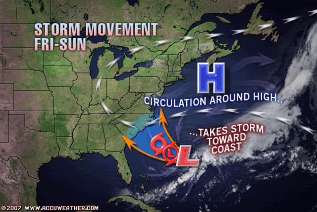
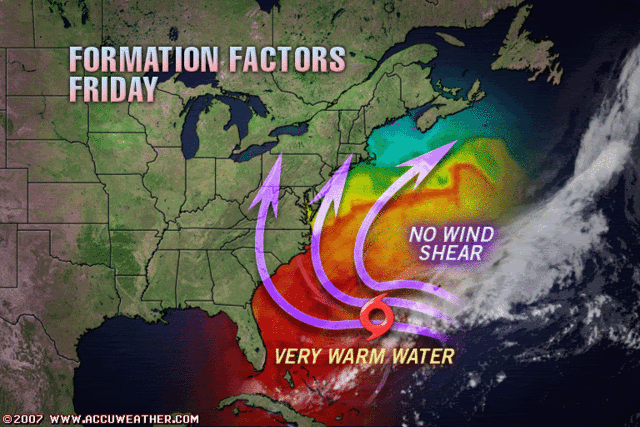
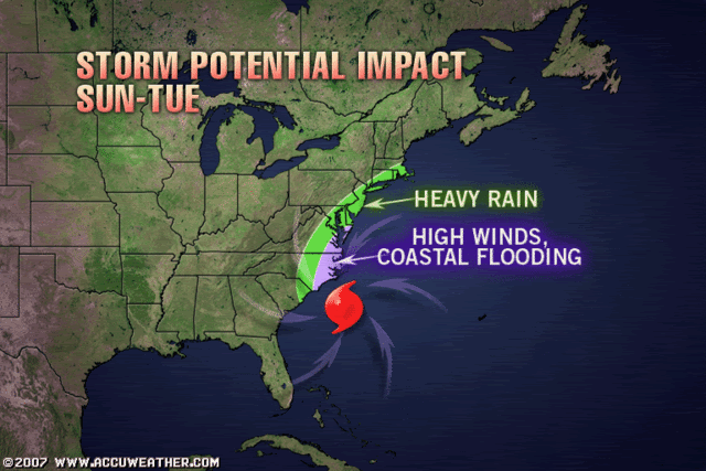
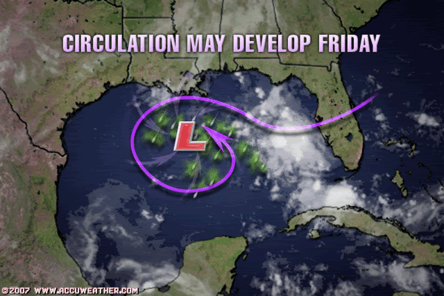
i've seen it all now, how about Gabrielle to be??? Any credibility they once had is slowly fading. I refer to them as "Accucrap", because its all pretty much dressed up BS.
seriously, my jaw just dropped seeing that...there is no way that will verify, people will be mocking that forecast forever!

0 likes
-
txwatcher91
- Category 5

- Posts: 1498
- Joined: Tue Aug 02, 2005 2:29 pm
Does anybody remember the wave/former TD that spawned Katrina? How about Andrew before it became a monster? This thing still has a chance as long as there is an LLC there. Our local met said that he did not expect it to begin developing until Friday, but that once it did, it would organize fairly quickly. I am not saying it will or will not develop, but I would not write 99L off just yet. Wait until tomorrow morning.
Edit- It is beginning to fire some storms to the N and the NW of the center. I would watch it tonight and see what it does.

Edit- It is beginning to fire some storms to the N and the NW of the center. I would watch it tonight and see what it does.

0 likes
- cycloneye
- Admin

- Posts: 149291
- Age: 69
- Joined: Thu Oct 10, 2002 10:54 am
- Location: San Juan, Puerto Rico
Re: 99L,Off U.S.E.Coast: Discussions-5:30 PM TWO Shortly
ABNT20 KNHC 062115
TWOAT
TROPICAL WEATHER OUTLOOK
NWS TPC/NATIONAL HURRICANE CENTER MIAMI FL
530 PM EDT THU SEP 6 2007
FOR THE NORTH ATLANTIC...CARIBBEAN SEA AND THE GULF OF MEXICO...
SHOWER ACTIVITY ASSOCIATED WITH THE NON-TROPICAL AREA OF LOW
PRESSURE ABOUT 350 MILES SOUTHWEST OF BERMUDA REMAINS DISORGANIZED.
WHILE UPPER-LEVEL WINDS ARE UNFAVORABLE FOR DEVELOPMENT...THEY
COULD BECOME MORE FAVORABLE OVER THE NEXT COUPLE OF DAYS...AND
THERE IS STILL SOME POTENTIAL FOR THIS SYSTEM TO BECOME A TROPICAL
CYCLONE. THE LOW IS DRIFTING ERRATICALLY AT THIS TIME...BUT IS
EXPECTED TO MOVE GENERALLY TOWARD THE NORTHWEST OVER THE NEXT DAY
OR SO.
ELSEWHERE...TROPICAL CYCLONE FORMATION IS NOT EXPECTED DURING THE
NEXT 48 HOURS.
$$
FORECASTER BEVEN
WWWW
0 likes
-
txwatcher91
- Category 5

- Posts: 1498
- Joined: Tue Aug 02, 2005 2:29 pm
Re: 99L,Off U.S.E.Coast: Discussions-5:30 PM TWO at page 67
Knowing this storm is going to develop is a lot easier than knowing where the storm will track. The longer the NHC waits to declare this a TD/TS the better handle they will have on potential tracks.
I will donate $5 to S2K if this does not develop into a TS, anyone want to make the reverse bet?
I will donate $5 to S2K if this does not develop into a TS, anyone want to make the reverse bet?
0 likes
Re: 99L,Off U.S.E.Coast: Discussions-5:30 PM TWO at page 67
Is there a thread/discussion on this somewhere??

0 likes
- windstorm99
- S2K Supporter

- Posts: 1578
- Age: 48
- Joined: Sat May 26, 2007 8:10 am
- Location: Miami, Florida
- Contact:
Re: 99L,Off U.S.E.Coast: Discussions-5:30 PM TWO at page 67
Ixolib wrote:Is there a thread/discussion on this somewhere??
http://www.storm2k.org/phpbb2/viewtopic.php?f=31&t=97757
0 likes
Re: 99L,Off U.S.E.Coast: Discussions-5:30 PM TWO at page 67
windstorm99 wrote:Ixolib wrote:Is there a thread/discussion on this somewhere??
http://www.storm2k.org/phpbb2/viewtopic.php?f=31&t=97757
Thanks!!
0 likes
- storms in NC
- S2K Supporter

- Posts: 2338
- Joined: Thu Jul 28, 2005 2:58 pm
- Location: Wallace,NC 40 miles NE of Wilm
- Contact:
I might be reading this wrong but it seem like Wilm is playing this down big time now.
MID LVL FLOW OVER THE SE BECOMES VERY WEAK ON SATURDAY. AT THE SFC
THE HIGH OFF OF THE JERSEY SHORE WILL BE SPITTING INTO A WEAK CELL
THAT WILL REMAIN ACRS THE SERN US AND A STRONGER CENTER ROUGHLY NEAR
37N 62W. THIS WILL ONCE AGAIN LEAD TO A DRY AFTERNOON WITH MAINLY
DIURNAL CU FIELDS. GFS IS SHOWING SOME COPIOUS MID LVL MOISTURE
ADVECTING IN AHEAD OF THE OFFSHORE LOW OVER FAR NERN ZONES. HOWEVER
SINCE THIS IS CURRENTLY THE VERY DRY SIDE OF THE STORM FEEL THAT
THIS IS OVERDONE UNLESS THE SYSTEM WERE TO STRENGTHEN AND BECOME
MUCH DEEPER AND MORE CLOSED OFF...WHICH IS CURRENTLY NOT THE
ACCEPTED SOLN. WILL STILL SHOW INC CLOUDS TO UPPER END PCLDY LATER
IN THE DAY AND THEN MOCLDY INTO SAT NIGHT. LOW END CHANCE POPS WILL
ALSO ACCOMPANY THIS INC IN MOISTURE LATER SAT AND SAT NIGHT.
CONFIDENCE IS ALREADY VERY LOW BY THE END OF THIS PD...AND SHOULD
THE WEAKER/FARTHER EAST SOLN TREND CONTINUE THEN SAT AND SATURDAY
NIGHT MAY END UP WITH A MOCLR AND DRY FCST. OF NOTE THOUGH IS THE
FACT THAT THERE ARE STILL MODEL SOLUTIONS THAT PORTRAY A MUCH
STRONGER WATL RIDGE AND THUS HAVE A MUCH MORE WRLY TRACK WITH THE
SYSTEM.
0 likes
- wxman57
- Moderator-Pro Met

- Posts: 23172
- Age: 68
- Joined: Sat Jun 21, 2003 8:06 pm
- Location: Houston, TX (southwest)
Re: 99L,Off U.S.E.Coast: Discussions-5:30 PM TWO at page 67
I don't know much about AccuWeather's clients or what they're expecting, but I do know what many industries that hire private meteorologists need in the way of weather information. Let's take the offshore drilling industry, for example. These are the most sensitive operations. I've sat down with engineers prior to the sail out of some VERY BIG deepwater production platform (by very big I mean multi-billion dollar operations) and they've told me that they need a quantitative assessment of the potential hurricane risk out to 10 days. They can't afford to depart port, make the slow 3-4 day journey out to mooring site then take 5-7 days to set at least 4 mooring lines if there is any significant risk of a hurricane impact. Such a strike could cause the loss of the platform and have the potential for damaging other nearby platforms and underwater pipelines.
Because of this, private meteorological firms are being asked for forecasts far and above anything that the NHC is prepared to issue (or needs to, given their main concern of public safety). How would you feel about issuing a 7-day track forecast on a tropical wave, predicting when and where it will develop and how large and strong it could become then communicating to a client the earliest time that a specific location could receive TS or hurricane force winds and the probability of receiving those winds? That's hard enough to do with a named storm, try it with a tropical wave. Like AccuWeather (I assume), we had the need to communicate the potential hurricane risk to our clients on the east coast because they pay us specifically to know of any potential risk out to 7 days and beyond. The difference here is that we only communicate the info to certain key people in each company. The forecasts aren't put out to the general public. Were the screen grabs from AccuWeather's public site or the paid site?
So the above reasons are why I'll sometimes say it isn't too early to make a forecast on a particular disturbance. That's what private meteorological companies have to do - make long-range forecasts when nothing is certain. We don't have the luxury of only discussing potential development over the next 36-48 hours. But we know that it is just as important to communicate to our clients when the risk is diminishing (as it has since late yesterday) so that our clients can "stand-down". I heard JB say today that he's sticking to his guns no matter what I guess only AccuWeather (or their clients) can determine if such a stance is in the clients' best interest. I like Joe, but he does tend to be a bit stubborn.
0 likes
- storms in NC
- S2K Supporter

- Posts: 2338
- Joined: Thu Jul 28, 2005 2:58 pm
- Location: Wallace,NC 40 miles NE of Wilm
- Contact:
Re:
pojo wrote:CARCAH has us tasked for tomorrow...we will see how things go in the morning.
By Friday afternoon this will be the talk of the town. Either how the models busted or how fast it build. One or the 2
0 likes
-
Coredesat
Re: Re:
storms in NC wrote:pojo wrote:CARCAH has us tasked for tomorrow...we will see how things go in the morning.
By Friday afternoon this will be the talk of the town. Either how the models busted or how fast it build. One or the 2
Well, there were recon missions scheduled for today; both were cancelled.
0 likes
- CalmBeforeStorm
- Category 2

- Posts: 600
- Age: 72
- Joined: Tue Aug 10, 2004 7:55 pm
- Location: Stuart, Florida
Re: Invest 99L,Off U.S.E.Coast: Discussions-Analysis & Imagery
I think 99L has reminded us that there are very few "shoe ins" when talking about tropical weather forecasting.
0 likes
Who is online
Users browsing this forum: No registered users and 11 guests


