CAT 5 Hurricane Dean - Archived threads
Moderator: S2k Moderators
-
gocuse08
Re: Global Models for TD4=12z GFS run rolling in
yeah its either going to go up the east coast or hit flordia this run :
0 likes
-
Ivanhater

- Storm2k Moderator

- Posts: 11221
- Age: 39
- Joined: Fri Jul 01, 2005 8:25 am
- Location: Pensacola
Re:
wxmann_91 wrote:That's about as close as a recurve as any run... but the progressiveness of the trough to the north and the building 500mb ridge suggests a turn back to the west...
Exactly...Trough doesnt look deep enough on the 500mb...but the end track has been thrown off completly
0 likes
-
MiamiensisWx
Re: E Atlantic: Tropical Depression Four Discussion Thread
The posts in this forum are NOT official forecast and should not be used as such. They are just the opinion of the poster and may or may not be backed by sound meteorological data. They are NOT endorsed by any professional institution or storm2k.org. For official information, please refer to the NHC and NWS products.
TD 4 looks unimpressive, but I think it will persist until it reaches a better environment. Latest visible imagery (per my personal view) indicates a new convective initiation occurring near 11.9N and 32.5W, which is located very close to the defined low-level circulation. The LLC appears to have been elongating and gaining a diffused appearance, which is not surprising under the mid-level easterly shear (roughly 20 kts). There is a defined band of outflow boundaries, and a weak devoid convergence line indicates a stable thermodynamic environment. I think the intermittent convective bursts could reduce the effects of the shear, so the depression could intensify when the diurnal maximum arrives each night.
http://www.ssd.noaa.gov/goes/flt/t1/loop-vis.html
http://cimss.ssec.wisc.edu/tropic/real-time/atlantic/winds/wg8sht.html
Note the relaxing shear further west, where conditions are more conducive for this system. On another note, I think I see two possible paths for this system. The ridge over the southern Plains should build eastward (per latest observations and model guidance); the questions regard the degree in which it will build; the effects of possible shortwaves rotating over the ridge (and through the broad Northeast trough); and the movement of TD 4, the effects of 91L, and the steering layers. A slower trough could draw TD 4 further north when it approaches the islands, but I don't think it could bring the system north along the coast (note that there are considerable uncertainities here). Thus far, I would expect that scenario to yield a path into the SE Bahamas, followed by a slow turn to the W or WNW (assuming the Plains ridge's influence verifies successfully).
A second possible path exists: the strong Azores ridge could suppress TD 4 on a southern path, which has been indicated by the model guidance. The fast mid-level steering should lose its influence once the system moves further west, but it would bring TD 4 closer to the islands within three or four days. Consequentially, it could (under this setup) miss the trough, which would partially support a general W or WNW path into the Caribbean basin. I would not go to specific details (it is too far out to make any good judgements).
Note - These are GENERAL paths - do not use them to guess a landfall. Do not take them as gospel.
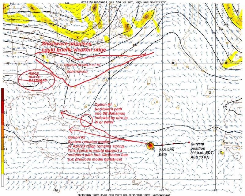
I would closely monitor TD 4 if you live anywhere in the islands, Caribbean, or Southeast United States...
TD 4 looks unimpressive, but I think it will persist until it reaches a better environment. Latest visible imagery (per my personal view) indicates a new convective initiation occurring near 11.9N and 32.5W, which is located very close to the defined low-level circulation. The LLC appears to have been elongating and gaining a diffused appearance, which is not surprising under the mid-level easterly shear (roughly 20 kts). There is a defined band of outflow boundaries, and a weak devoid convergence line indicates a stable thermodynamic environment. I think the intermittent convective bursts could reduce the effects of the shear, so the depression could intensify when the diurnal maximum arrives each night.
http://www.ssd.noaa.gov/goes/flt/t1/loop-vis.html
http://cimss.ssec.wisc.edu/tropic/real-time/atlantic/winds/wg8sht.html
Note the relaxing shear further west, where conditions are more conducive for this system. On another note, I think I see two possible paths for this system. The ridge over the southern Plains should build eastward (per latest observations and model guidance); the questions regard the degree in which it will build; the effects of possible shortwaves rotating over the ridge (and through the broad Northeast trough); and the movement of TD 4, the effects of 91L, and the steering layers. A slower trough could draw TD 4 further north when it approaches the islands, but I don't think it could bring the system north along the coast (note that there are considerable uncertainities here). Thus far, I would expect that scenario to yield a path into the SE Bahamas, followed by a slow turn to the W or WNW (assuming the Plains ridge's influence verifies successfully).
A second possible path exists: the strong Azores ridge could suppress TD 4 on a southern path, which has been indicated by the model guidance. The fast mid-level steering should lose its influence once the system moves further west, but it would bring TD 4 closer to the islands within three or four days. Consequentially, it could (under this setup) miss the trough, which would partially support a general W or WNW path into the Caribbean basin. I would not go to specific details (it is too far out to make any good judgements).
Note - These are GENERAL paths - do not use them to guess a landfall. Do not take them as gospel.
I would closely monitor TD 4 if you live anywhere in the islands, Caribbean, or Southeast United States...
0 likes
-
Aquawind

- Category 5

- Posts: 6714
- Age: 62
- Joined: Mon Jun 16, 2003 10:41 pm
- Location: Salisbury, NC
- Contact:
Re: E Atlantic: Tropical Depression Four Discussion Thread
45
FZNT02 KNHC 131624
HSFAT2
HIGH SEAS FORECAST
NWS TPC/NATIONAL HURRICANE CENTER MIAMI FL
1630 UTC MON AUG 13 2007
SUPERSEDED BY NEXT ISSUANCE IN 6 HOURS
SECURITE
ATLANTIC FROM 7N TO 31N W OF 35W INCLUDING CARIBBEAN SEA AND
GULF OF MEXICO
SYNOPSIS VALID 1200 UTC MON AUG 13
24 HOUR FORECAST VALID 1200 UTC TUE AUG 14
48 HOUR FORECAST VALID 1200 UTC WED AUG 15
.WARNINGS.
.TROPICAL DEPRESSION FOUR AT 12.0N 31.6W 1005 MB AT 1500 UTC AUG 13
MOVING W OR 265 DEG AT 18 KT. MAXIMUM SUSTAINED WIND 30 GUSTS 40 KT.
.24 HOUR FORECAST TROPICAL STORM NEAR 11.9N 38.0W. MAXIMUM
SUSTAINED WIND 40 GUSTS 50 KT. TROPICAL STORM FORCE WIND WITHIN 40
NM N SEMICIRCLE. SEAS 12 FT OR GREATER WITHIN 60 NM N OF CENTER WITH
SEAS TO 14 FT.
.48 HOUR FORECAST TROPICAL STORM NEAR 11.9N 44.7W. MAXIMUM
SUSTAINED WIND 50 GUSTS 60 KT. TROPICAL STORM FORCE WINDS WITHIN 60
NM N SEMICIRCLE AND 40 NM S SEMICIRCLE. SEAS 12 FT OR GREATER
WITHIN 90 NM OF CENTER WITH SEAS TO 15 FT.
.72 HOUR FORECAST TROPICAL STORM NEAR 13.0N 51.0W. MAXIMUM
SUSTAINED WIND 60 GUSTS 75 KT.
EXTENDED OUTLOOK...USE FOR GUIDANCE ONLY...ERRORS MAY BE LARGE.
.96 HOUR FORECAST HURRICANE NEAR 14.5N 57.5W. MAXIMUM SUSTAINED
WIND 75 GUSTS 90 KT.
.120 HOUR FORECAST HURRICANE NEAR 16.0N 63.5W. MAXIMUM SUSTAINED
WIND 90 GUSTS 110 KT...SYNOPSIS AND FORECAST.
.ATLC WITHIN 90 NM N AND 45 NM S SEMICIRCLES OF TROPICAL DEPRESSION
FOUR WIND 20 TO 25 KT SEAS TO 10 FT.
.24 HOUR FORECAST WITHIN 240 NM N AND 120 NM S SEMICIRCLES OF
TROPICAL STORM FOUR WIND TO 33 KT SEAS TO 12 FT.
.48 HOUR FORECAST WITHIN 480 NM N AND 180 NM S SEMICIRCLES OF
TROPICAL STORM FOUR WIND TO 33 KT SEAS TO 12 FT. ELSEWHERE FROM
14N TO 22N E OF 60W NE TO E WIND 20 KT SEAS TO 9 FT IN E SWELL.
.ATLC 12 HOUR FORECAST TROUGH 31N70W 29N78W. N OF 30N WITHIN 480
NM E OF TROUGH SW WIND TO 20 KT SEAS LESS THAN 8 FT.
.24 HOUR FORECAST TROUGH 31N66W 27N72W. N OF 27N WITHIN 240 NM
E OF TROUGH SW WIND TO 20 KT SEAS LESS THAN 8 FT.
.48 HOUR FORECAST TROUGH 31N62W 27N70W. N OF 29N WITHIN 240 NM
E OF TROUGH SW WIND TO 20 KT SEAS TO 8 FT.
.CARIBBEAN FROM 12N TO 18N BETWEEN 68W AND 80W
E TO SE WIND 20 TO 25 KT SEAS TO 9 FT.
.24 HOUR FORECAST FROM 12N TO 19N BETWEEN 68W AND 78W E WIND 20
KT SEAS TO 8 FT IN E SWELL. FROM 15N TO 20N BETWEEN 78W AND 86W
E TO SE WIND TO 20 KT SEAS TO 9 FT IN E SWELL.
.48 HOUR FORECAST FROM 11N TO 15N BETWEEN 68W AND 78W E WIND TO 20
KT SEAS LESS THAN 8 FT. N OF 15N W OF 82W E TO SE WIND TO 20 KT
SEAS TO 8 FT.
.GULF OF MEXICO 24 HOUR FORECAST TROUGH 30N91W 25N94W. WITHIN 90
NM W OF TROUGH NE WIND TO 20 KT SEAS LESS THAN 8 FT. WITHIN 240
NM E OF TROUGH SE WIND TO 20 KT SEAS TO 8 FT.
.48 HOUR FORECAST TROUGH 29N96W 22N97W. N OF 25N W OF 92W
SE WIND TO 20 KT SEAS TO 8 FT.
.REMAINDER OF AREA WIND LESS THAN 20 KT SEAS LESS THAN 8 FT.
$$
FORECASTER WALLY BARNES
TROPICAL PREDICTION CENTER
TROPICAL ANALYSIS AND FORECAST BRANCH
0 likes


Re: Global Models for TD4=12z GFS run rolling in
It looks like the ridge in the southeast is moving and building rapidly eastward however at 132-144 hours and may catch it just in time to take it west or even westsouthwest into the Gulf nevertheless.
0 likes
-
storms in NC

- S2K Supporter

- Posts: 2338
- Joined: Thu Jul 28, 2005 2:58 pm
- Location: Wallace,NC 40 miles NE of Wilm
- Contact:

-
wxmann_91

- Category 5
- Posts: 8007
- Age: 34
- Joined: Fri Jul 15, 2005 2:49 pm
- Location: Southern California
- Contact:
Re:
storms in NC wrote:This is just one run. I think we need to wait and see if it does happen to trun North. But IMO I don't think so. Still say Ga to NC safe
The 180 degree shift of the synoptic pattern near the Bahamas from the 0Z-12Z GFS should be an indicator of the unpredictability this far out... nobody is out of the cone of uncertainty.
0 likes
-
MiamiensisWx
Re: Global Models for TD4=12z GFS run rolling in
This run takes it into the southeastern Bahamas, where the weakness seems to lose its influence. This run looks like a SE Florida threat.
http://www.nco.ncep.noaa.gov/pmb/nwprod/analysis/carib/gfs/12/images/gfs_500_150l.gif
I bet it will change - I will not place too much confidence in any scenario.
http://www.nco.ncep.noaa.gov/pmb/nwprod/analysis/carib/gfs/12/images/gfs_500_150l.gif
I bet it will change - I will not place too much confidence in any scenario.
0 likes
-
Brent
- S2K Supporter
- Posts: 38729
- Age: 37
- Joined: Sun May 16, 2004 10:30 pm
- Location: Tulsa Oklahoma
- Contact:
Re: Global Models for TD4=12z GFS run rolling in
Approaching the NW and Central Bahamas!
http://www.nco.ncep.noaa.gov/pmb/nwprod ... n_174l.gif
At 500 mb:
http://www.nco.ncep.noaa.gov/pmb/nwprod ... 0_174l.gif
http://www.nco.ncep.noaa.gov/pmb/nwprod ... n_174l.gif
At 500 mb:
http://www.nco.ncep.noaa.gov/pmb/nwprod ... 0_174l.gif
Last edited by Brent on Mon Aug 13, 2007 11:37 am, edited 1 time in total.
0 likes
-
KFDM Meteorologist

- Professional-Met

- Posts: 1314
- Joined: Tue May 16, 2006 9:52 pm
- Location: Upper Texas Coast/Orange County
-
destruction92
- Category 1

- Posts: 312
- Joined: Sun Jul 22, 2007 10:43 pm
Re: Global Models for TD4=12z GFS run rolling in
vaffie wrote:It looks like the ridge in the southeast is moving and building rapidly eastward however at 132-144 hours and may catch it just in time to take it west or even westsouthwest into the Gulf nevertheless.
Are you hinting at a Rita-like scenario?
0 likes
-
Scorpion
-
El Nino

- Category 1
- Posts: 454
- Age: 48
- Joined: Sun Oct 16, 2005 3:18 pm
- Location: Lima - Miraflores (Peru)
- Contact:
Re: E Atlantic: Tropical Depression Four Discussion Thread
Hmmm this track is not good for Haiti ! Amajor hurricane is just what they don't need ! 
0 likes
-
KFDM Meteorologist
- Professional-Met
- Posts: 1314
- Joined: Tue May 16, 2006 9:52 pm
- Location: Upper Texas Coast/Orange County
-
southerngale

- Retired Staff

- Posts: 27418
- Joined: Thu Oct 10, 2002 1:27 am
- Location: Southeast Texas (Beaumont area)
DEAN Advisories & Official Forecast Maps=Last Advisory
I was surprised there wasn't already a thread for this. Anyhow, this is for advisories and forecast track maps only.
If you post the track maps, please save them to Imageshack or a place like that, so we can see the new maps each time. Otherwise, it will always show the current track map, even in the older posts.
000
WTNT34 KNHC 131454
TCPAT4
BULLETIN
TROPICAL DEPRESSION FOUR ADVISORY NUMBER 1
NWS TPC/NATIONAL HURRICANE CENTER MIAMI FL AL042007
1100 AM EDT MON AUG 13 2007
...FOURTH DEPRESSION OF THE SEASON FORMS IN THE FAR EASTERN
ATLANTIC...
AT 1100 AM EDT...1500Z...THE CENTER OF TROPICAL DEPRESSION FOUR WAS
LOCATED NEAR LATITUDE 12.0 NORTH...LONGITUDE 31.6 WEST OR ABOUT 520
MILES...840 KM...WEST-SOUTHWEST OF THE SOUTHERNMOST CAPE VERDE
ISLANDS AND ABOUT 2000 MILES...3220 KM...EAST OF THE LESSER
ANTILLES.
THE DEPRESSION IS MOVING TOWARD THE WEST NEAR 21 MPH...AND THIS
GENERAL MOTION IS EXPECTED TO CONTINUE DURING THE NEXT 24 HOURS.
MAXIMUM SUSTAINED WINDS ARE NEAR 35 MPH...55 KM/HR...WITH HIGHER
GUSTS. SOME STRENGTHENING IS FORECAST...AND THE DEPRESSION COULD
BECOME A TROPICAL STORM DURING THE NEXT 24 HOURS.
ESTIMATED MINIMUM CENTRAL PRESSURE IS 1005 MB...29.68 INCHES.
REPEATING THE 1100 AM EDT POSITION...12.0 N...31.6 W. MOVEMENT
TOWARD...WEST NEAR 21 MPH. MAXIMUM SUSTAINED WINDS...35 MPH.
MINIMUM CENTRAL PRESSURE...1005 MB.
THE NEXT ADVISORY WILL BE ISSUED BY THE NATIONAL HURRICANE CENTER AT
500 PM EDT.
$$
FORECASTER KNABB
000
WTNT24 KNHC 131450
TCMAT4
TROPICAL DEPRESSION FOUR FORECAST/ADVISORY NUMBER 1
NWS TPC/NATIONAL HURRICANE CENTER MIAMI FL AL042007
1500 UTC MON AUG 13 2007
TROPICAL DEPRESSION CENTER LOCATED NEAR 12.0N 31.6W AT 13/1500Z
POSITION ACCURATE WITHIN 20 NM
PRESENT MOVEMENT TOWARD THE WEST OR 265 DEGREES AT 18 KT
ESTIMATED MINIMUM CENTRAL PRESSURE 1005 MB
MAX SUSTAINED WINDS 30 KT WITH GUSTS TO 40 KT.
WINDS AND SEAS VARY GREATLY IN EACH QUADRANT. RADII IN NAUTICAL
MILES ARE THE LARGEST RADII EXPECTED ANYWHERE IN THAT QUADRANT.
REPEAT...CENTER LOCATED NEAR 12.0N 31.6W AT 13/1500Z
AT 13/1200Z CENTER WAS LOCATED NEAR 12.1N 30.7W
FORECAST VALID 14/0000Z 12.0N 34.3W
MAX WIND 35 KT...GUSTS 45 KT.
34 KT... 30NE 0SE 0SW 30NW.
FORECAST VALID 14/1200Z 11.9N 38.0W
MAX WIND 40 KT...GUSTS 50 KT.
34 KT... 40NE 0SE 0SW 40NW.
FORECAST VALID 15/0000Z 11.9N 41.4W
MAX WIND 45 KT...GUSTS 55 KT.
34 KT... 50NE 30SE 30SW 50NW.
FORECAST VALID 15/1200Z 11.9N 44.7W
MAX WIND 50 KT...GUSTS 60 KT.
50 KT... 30NE 0SE 0SW 30NW.
34 KT... 60NE 40SE 40SW 60NW.
FORECAST VALID 16/1200Z 13.0N 51.0W
MAX WIND 60 KT...GUSTS 75 KT.
50 KT... 40NE 25SE 25SW 40NW.
34 KT... 75NE 50SE 50SW 75NW.
EXTENDED OUTLOOK. NOTE...ERRORS FOR TRACK HAVE AVERAGED NEAR 225 NM
ON DAY 4 AND 300 NM ON DAY 5...AND FOR INTENSITY NEAR 20 KT EACH DAY
OUTLOOK VALID 17/1200Z 14.5N 57.5W
MAX WIND 75 KT...GUSTS 90 KT.
OUTLOOK VALID 18/1200Z 16.0N 63.5W
MAX WIND 90 KT...GUSTS 110 KT.
REQUEST FOR 3 HOURLY SHIP REPORTS WITHIN 300 MILES OF 12.0N 31.6W
NEXT ADVISORY AT 13/2100Z
$$
FORECASTER KNABB
0 likes
-
vacanechaser

- Category 5
- Posts: 1461
- Joined: Wed Dec 03, 2003 9:34 pm
- Location: Portsmouth, Va
- Contact:
look at the 500mb... there is a ridge building to its northeast and a ridge building to its west over the panhandle... would it not hit the weakness between the two and possibly run the coast on this run???
Jesse V. Bass III
http://www.vastormphoto.com
Hurricane Intercept Research Team
Jesse V. Bass III
http://www.vastormphoto.com
Hurricane Intercept Research Team
0 likes
-
Brent
- S2K Supporter
- Posts: 38729
- Age: 37
- Joined: Sun May 16, 2004 10:30 pm
- Location: Tulsa Oklahoma
- Contact:
Re: Global Models for TD4=12z GFS run rolling in
I am officially confused as to where this run is going... 
0 likes
-
southerngale
- Retired Staff
- Posts: 27418
- Joined: Thu Oct 10, 2002 1:27 am
- Location: Southeast Texas (Beaumont area)

Who is online
Users browsing this forum: No registered users and 44 guests