CAT 5 Hurricane Dean - Archived threads
Moderator: S2k Moderators
-
KFDM Meteorologist

- Professional-Met

- Posts: 1314
- Joined: Tue May 16, 2006 9:52 pm
- Location: Upper Texas Coast/Orange County
-
destruction92
- Category 1

- Posts: 312
- Joined: Sun Jul 22, 2007 10:43 pm
Re: Tropical Storm Dean (pg.28) 18z Tropical Models Posted
Opal storm wrote:Extremecane wrote:Explodes as soon it gets to the gulf:
Well that cetainly wouldn't be good for me, but that track is highly unlikely IMO. We've had this strong ridge over us for almost a month now, highs near 100 everyday with clear skies. Unless there's a huge pattern change in the next 2 weeks I'm really not concered about anything of that nature coming this way.

...EASTERN UNITED STATES...
A VIGOROUS COLD FRONT WILL SLICE ALL THE WAY INTO THE SOUTHEASTERN
UNITED STATES THIS PERIOD...WITH COOL...DRY...CONTINENTAL POLAR
AIR FOLLOWING IN ITS WAKE. LOWS SUNDAY MORNING WILL BE MORE
REMINISCENT OF FALL THAN LATE SUMMER ACROSS THE INTERIOR
NORTHEAST...WITH SOME COLDER SPOTS IN THE 30S.
Source:
http://www.hpc.ncep.noaa.gov/discussions/pmdepd.html
0 likes
-
windycity

- S2K Supporter

- Posts: 461
- Joined: Wed Aug 24, 2005 6:45 pm
- Location: P.B.county,Fl.
- Contact:
Re: Tropical Storm Dean (pg.28) Discussions,Analysis and Imagery
Derek, you mentioned you didn't expect to see Dean putting on the brakes and feeling the effects of the dry air. What are your thoughts now?
0 likes
-
Coredesat


destruction,
Your profile doesn't give your location, but you've been fighting that east coast battle for a couple of days (or so it seems).
Forget the trough. What's behind a trough or a front? A large dome of high pressure. That dome has been forecast in various runs to link up with subtropical ridging in the Atlantic. Unless a trough was to kick it up and out, what's behind that trough will absolutely NOT do so. It, as it always is with troughs and fronts coming south or southeast through the U.S. and A., an issue of timing.
Steve
0 likes
-
destruction92
- Category 1
- Posts: 312
- Joined: Sun Jul 22, 2007 10:43 pm
Re:
KFDM Meteorologist wrote:GOM!!!
How can you know it is GOM this early? I could understand if you said, "CARRIBEAN!!!". Seriously, are you desire-casting or something? Even your avatar is Hurricane Rita and your from Texas.
Most of the models take Dean through the Dominican Republic while moving NW towards the Bahamas. How is that GOM?
Have you seen the latest EURO model?
0 likes
-
KFDM Meteorologist
- Professional-Met
- Posts: 1314
- Joined: Tue May 16, 2006 9:52 pm
- Location: Upper Texas Coast/Orange County
Re: Tropical Storm Dean - Global Models
I think he means that the end track will end up in the GOM, be it through the Caribbean or through Florida
0 likes
-
KFDM Meteorologist
- Professional-Met
- Posts: 1314
- Joined: Tue May 16, 2006 9:52 pm
- Location: Upper Texas Coast/Orange County
-
Derek Ortt
Re: Tropical Storm Dean (pg.28) Discussions,Analysis and Imagery
storm needs convection very very soon. Not looking healthy at all this afternoon
0 likes
-
destruction92
- Category 1
- Posts: 312
- Joined: Sun Jul 22, 2007 10:43 pm
Re:
KFDM Meteorologist wrote:Yes i have seen it!
Before making a one-liner statement such as "GOM!!!", I think it would be better if you gave some valid reasoning behind your interjection. You are a meteorologist, so I am sure you can give us more information than just an open-ended one-word statement.
0 likes
-
storms in NC

- S2K Supporter
- Posts: 2338
- Joined: Thu Jul 28, 2005 2:58 pm
- Location: Wallace,NC 40 miles NE of Wilm
- Contact:
Re:
Steve wrote:destruction,
Your profile doesn't give your location, but you've been fighting that east coast battle for a couple of days (or so it seems).
Forget the trough. What's behind a trough or a front? A large dome of high pressure. That dome has been forecast in various runs to link up with subtropical ridging in the Atlantic. Unless a trough was to kick it up and out, what's behind that trough will absolutely NOT do so. It, as it always is with troughs and fronts coming south or southeast through the U.S. and A., an issue of timing.
Steve
They are from CAMP SPRINGS MD
But I am from NC and we have as much chance then any one at this time. Will it NO! but it has the same for any one. Just my two cents
0 likes
-
destruction92
- Category 1
- Posts: 312
- Joined: Sun Jul 22, 2007 10:43 pm
Re: Tropical Storm Dean - Global Models
caneseddy wrote:I think he means that the end track will end up in the GOM, be it through the Caribbean or through Florida
Oh, I see. It was hard for me to read KDFM's mind across cyberspace.
0 likes
-
HURAKAN

- Professional-Met
- Posts: 46084
- Age: 39
- Joined: Thu May 20, 2004 4:34 pm
- Location: Key West, FL
- Contact:
Re: Tropical Storm Dean (pg.28) Discussions,Analysis and Imagery
Derek Ortt wrote:storm needs convection very very soon. Not looking healthy at all this afternoon

Not that bad!! I guess the DMAX should allow the system to develop deeper convection.
0 likes
It's all good. The other complicating factor is what happens with that airmass? The last trough/front kind of split with a semi-dry pocket hitting parts of southern Mississippi (Columbia +/-) with some low dew points for a day. It's gonna be an intense week that's for sure - and that's for all of us. I'm one of the very few people with nothing left to lose, so it's not that big a deal to me. I pile my kids in the truck and the few bins of photos we saved, and we're homefree (wherever home is).
Steve
Steve
0 likes

Re:
Steve wrote:It's all good. The other complicating factor is what happens with that airmass? The last trough/front kind of split with a semi-dry pocket hitting parts of southern Mississippi (Columbia +/-) with some low dew points for a day. It's gonna be an intense week that's for sure - and that's for all of us. I'm one of the very few people with nothing left to lose, so it's not that big a deal to me. I pile my kids in the truck and the few bins of photos we saved, and we're homefree (wherever home is).
Steve
Steve; Home is where your family is located, healthy and happy.
0 likes


http://hadar.cira.colostate.edu/ramsdis ... ive_0.html
Well as you can see in the loop the sun is starting to set over Dean.
i say around 7pm it will start reforming its convection.
Well as you can see in the loop the sun is starting to set over Dean.
i say around 7pm it will start reforming its convection.
0 likes

Re: Tropical Storm Dean - Global Models
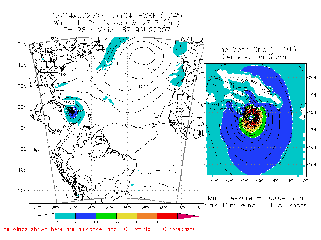
Wow, 12Z Euro is sure devastating to FL - let's all hope that doesn't come true. A couple of observations from a comparison of the 12Z GFS and 12Z Euro. The GFS is generally weaker with the storm and much faster as it races the system to the leeward islands in 3 days on a low latitude. The intensity is not even 1000 mb by the time it reaches the leewards. Perhaps this is correct if it doesn't strengthen significantly and stays a weak tropical storm. You'll also notice the 12Z UKMET barely develops it and has it skimmimg along the coast of S America - mainly caught in the westerly low level flow.
On the other hand, if you examine the 12Z Euro it maintains and strengthens the system and feels the effect of the west Atlantic trough (or weaker upper air ridge) initially to get it to a higher latitude and then the trough lifts out and it stays on a general W-NW heading to south Florida, probably as a major hurricane. The HWRF model, which intensifies this storm to an impressive 135 kts prior to impact with the SE coast of DR, seems to be more closely aligned with the 12Z Euro.
So, what does this mean? Probably nothing since the model runs are out past 3 days and upper level conditions are generally not forecast with enough precision 5-7 days out. But, I think intensity will be a key as a strong storm will likely get pulled north of the greater antilles versus a weaker one will travel the caribbean sea.
0 likes
Who is online
Users browsing this forum: No registered users and 112 guests