Game on! I'll be preparing my equipment tomorrow then maybe ship out on Tuesday closer to landfall zone. It's looking like I won't have to travel very far, somewhere between Ningbo and Wenzhou I guess.
I'm going to start a new thread shortly to cover this potential intercept.
TD ex-WIPHA (WPAC) - LANDFALL
Moderator: S2k Moderators
-
Typhoon Hunter
- WesternPacificWeather.com

- Posts: 1222
- Joined: Wed Oct 11, 2006 11:37 am
- Location: Tokyo
- Contact:
-
CrazyC83
- Professional-Met

- Posts: 34315
- Joined: Tue Mar 07, 2006 11:57 pm
- Location: Deep South, for the first time!
Re: Tropical Storm WIPHA 13W SE of Okinawa (WPAC)
Typhoon Hunter wrote:Game on! I'll be preparing my equipment tomorrow then maybe ship out on Tuesday closer to landfall zone. It's looking like I won't have to travel very far, somewhere between Ningbo and Wenzhou I guess.
I'm going to start a new thread shortly to cover this potential intercept.
Have fun and stay safe! Glad to have typhoon hunters on here!
0 likes
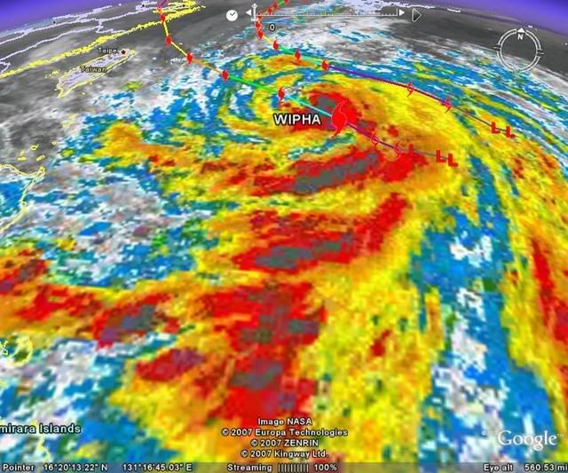


Re: Severe Tropical Storm WIPHA 13W SE of Okinawa (WPAC)
Where did Wipha come from? I thought Vipa was next on the list.
0 likes
-
HURAKAN

- Professional-Met
- Posts: 46084
- Age: 39
- Joined: Thu May 20, 2004 4:34 pm
- Location: Key West, FL
- Contact:
Re: Severe Tropical Storm WIPHA 13W SE of Okinawa (WPAC)
Jam151 wrote:Where did Wipha come from? I thought Vipa was next on the list.
You're right and I don't know why "Wipha" is being used when Vipa in 2001 was a harmless system that didn't make landfall.
But in the JMA name list "Vipa" is replaced by "Wipha" while in the NHC's website the name that appears is "Vipa."
Wikipedia:
2004 (Vipa): http://en.wikipedia.org/wiki/2004_Pacif ... oon_season
2005 (Wipha): http://en.wikipedia.org/wiki/2005_Pacif ... oon_season
I can't find an explanation of why the name changed.
0 likes

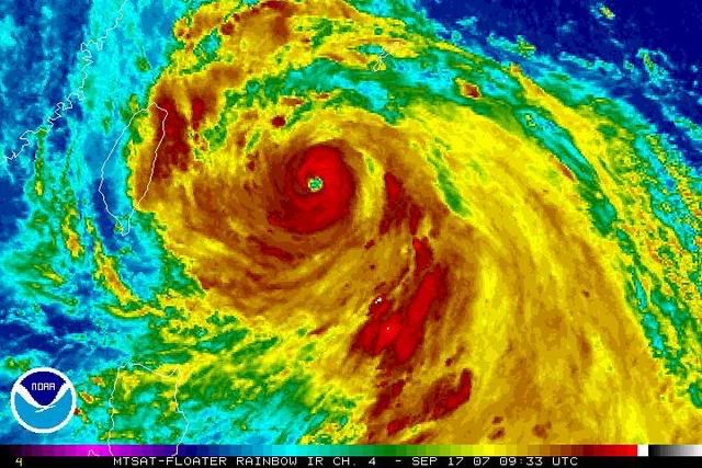
816
WTPQ21 RJTD 170300
RSMC TROPICAL CYCLONE ADVISORY
NAME TY 0712 WIPHA (0712) UPGRADED FROM STS
ANALYSIS
PSTN 170300UTC 22.7N 127.1E GOOD
MOVE WNW 10KT
PRES 965HPA
MXWD 070KT
GUST 100KT
50KT 65NM
30KT 220NM NORTHEAST 140NM SOUTHWEST
FORECAST
24HF 180300UTC 24.8N 123.3E 80NM 70%
MOVE NW 10KT
PRES 960HPA
MXWD 075KT
GUST 105KT
45HF 190000UTC 27.1N 121.0E 150NM 70%
MOVE NW 09KT
PRES 970HPA
MXWD 065KT
GUST 095KT
69HF 200000UTC 30.6N 120.2E 220NM 70%
MOVE N 09KT
PRES 985HPA
MXWD 050KT
GUST 070KT =
0 likes
-
WindRunner

- Category 5

- Posts: 5803
- Age: 35
- Joined: Fri Jul 29, 2005 8:07 pm
- Location: Warrenton, VA, but Albany, NY for school
- Contact:

-
WindRunner
- Category 5
- Posts: 5803
- Age: 35
- Joined: Fri Jul 29, 2005 8:07 pm
- Location: Warrenton, VA, but Albany, NY for school
- Contact:


-
Matt-hurricanewatcher
Re: Typhoon WIPHA (0712) E of Taiwan (WPAC)
WOW that city is one of the largest on earth. If this is still at cat3+ when it moves over it, then you could not find a more memberable storm.
0 likes

-
Dave C
- S2K Supporter

- Posts: 868
- Joined: Thu Sep 04, 2003 4:36 pm
- Location: Middleboro, Mass.(midway between Cape Cod and Boston)
Re: Typhoon WIPHA (0712) E of Taiwan (WPAC)
The island of Miyaka Jima is going to see landfall in about 10 hrs, Jim leonard shot some video from there in the 90s when he lived in Guam. I posted a link to radar which you can zoom-in and the eyewall is really developing nicely. That island is in for a wild ride! 
0 likes
Who is online
Users browsing this forum: No registered users and 34 guests