Tropical Depression GABRIELLE:Discussions and Images

Moderator: S2k Moderators

Message
Author
User avatar
HURAKAN
Professional-Met
Professional-Met
Posts: 46086
Age: 38
Joined: Thu May 20, 2004 4:34 pm
Location: Key West, FL
Contact:

Re: Subtropical Storm GABRIELLE (ATL): Discussions and Images

#241 Postby HURAKAN » Sat Sep 08, 2007 12:16 pm

LETS COMPARE:

A.
Image

B.
Image

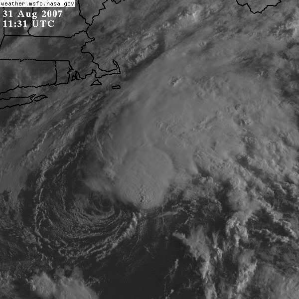
If you were asked without previous knowledge of Gabrielle, which one is a named subtropical storm? A or B?

Without even thinking I would have answered B.
0 likes   

Zardoz
Category 1
Category 1
Posts: 309
Joined: Fri Aug 25, 2006 9:48 am
Location: Severe weather-challenged Southern California

Re: Subtropical Storm GABRIELLE (ATL): Discussions and Images

#242 Postby Zardoz » Sat Sep 08, 2007 12:19 pm

wxman57 wrote:98L is NOT back. What you're looking at is the wave that moved off the west coast of Africa 3-4 days after 98L.

Yes, that's true. However, I sat and watched that wave absorb the remnants of 98L.

Does that count?
0 likes   

User avatar
artist
Category 5
Category 5
Posts: 9792
Joined: Mon Jun 06, 2005 3:26 pm
Location: West Palm

#243 Postby artist » Sat Sep 08, 2007 12:20 pm

thank you both wxman and frank2. Great explanations that I could understand!
0 likes   

Frank2
Category 5
Category 5
Posts: 4061
Joined: Mon Jul 25, 2005 12:47 pm

Re: Subtropical Storm GABRIELLE (ATL): Discussions and Images

#244 Postby Frank2 » Sat Sep 08, 2007 12:22 pm

wxamn, that sounds like the old parallax issue...

http://en.wikipedia.org/wiki/Parallax

the other night, I could not see a star looking directly at it - unless I looked about 10 degrees to the left...
0 likes   

User avatar
HURAKAN
Professional-Met
Professional-Met
Posts: 46086
Age: 38
Joined: Thu May 20, 2004 4:34 pm
Location: Key West, FL
Contact:

#245 Postby HURAKAN » Sat Sep 08, 2007 12:23 pm

Latest:

Image
0 likes   

RL3AO
Moderator-Pro Met
Moderator-Pro Met
Posts: 16308
Joined: Thu Jun 14, 2007 10:03 pm
Location: NC

#246 Postby RL3AO » Sat Sep 08, 2007 12:26 pm

Well, you can't say theres not a well defined circulation, but theres not much else to say.
0 likes   

Extremecane
Tropical Depression
Tropical Depression
Posts: 70
Joined: Sat Aug 11, 2007 1:22 pm

Re: Subtropical Storm GABRIELLE (ATL): Discussions and Images

#247 Postby Extremecane » Sat Sep 08, 2007 12:39 pm

Accu expects this to be a hurricane?

Image
0 likes   

User avatar
HURAKAN
Professional-Met
Professional-Met
Posts: 46086
Age: 38
Joined: Thu May 20, 2004 4:34 pm
Location: Key West, FL
Contact:

#248 Postby HURAKAN » Sat Sep 08, 2007 12:42 pm

LATEST:

Image
0 likes   

User avatar
wxman57
Moderator-Pro Met
Moderator-Pro Met
Posts: 22978
Age: 67
Joined: Sat Jun 21, 2003 8:06 pm
Location: Houston, TX (southwest)

Re: Subtropical Storm GABRIELLE (ATL): Discussions and Images

#249 Postby wxman57 » Sat Sep 08, 2007 12:47 pm

Zardoz wrote:
wxman57 wrote:98L is NOT back. What you're looking at is the wave that moved off the west coast of Africa 3-4 days after 98L.

Yes, that's true. However, I sat and watched that wave absorb the remnants of 98L.

Does that count?


I saw the same thing. Let's call it 98.5L. :lol:
0 likes   

User avatar
HURAKAN
Professional-Met
Professional-Met
Posts: 46086
Age: 38
Joined: Thu May 20, 2004 4:34 pm
Location: Key West, FL
Contact:

Re: Subtropical Storm GABRIELLE (ATL): Discussions and Images

#250 Postby HURAKAN » Sat Sep 08, 2007 12:48 pm

Latest:

Image

Image
0 likes   

User avatar
wxman57
Moderator-Pro Met
Moderator-Pro Met
Posts: 22978
Age: 67
Joined: Sat Jun 21, 2003 8:06 pm
Location: Houston, TX (southwest)

Re: Subtropical Storm GABRIELLE (ATL): Discussions and Images

#251 Postby wxman57 » Sat Sep 08, 2007 12:53 pm

Here's a 2-hr movement from 1532Z-1732Z. Toward 3.8 degrees and 27.7 miles. That's 14 mph to the north. Well east of NHC's and my track now. I estimate the center will cross 32N near 74.1 or 74.2W longitude. That's about 0.8 to 0.9 deg. east of the morning tracks.
0 likes   

User avatar
vacanechaser
Category 5
Category 5
Posts: 1461
Joined: Wed Dec 03, 2003 9:34 pm
Location: Portsmouth, Va
Contact:

Re: Subtropical Storm GABRIELLE (ATL): Discussions and Images

#252 Postby vacanechaser » Sat Sep 08, 2007 12:58 pm

wxman57 wrote:Here's a 2-hr movement from 1532Z-1732Z. Toward 3.8 degrees and 27.7 miles. That's 14 mph to the north. Well east of NHC's and my track now. I estimate the center will cross 32N near 74.1 or 74.2W longitude. That's about 0.8 to 0.9 deg. east of the morning tracks.


it looks like in the last frame it is starting to make a turn back the northwest... maybe


Jesse V. Bass III
http://www.vastormphoto.com
Hurricane Intercept Research Team
0 likes   

User avatar
Chacor
Category 5
Category 5
Posts: 10229
Joined: Mon Oct 02, 2006 10:43 pm
Location: Singapore

#253 Postby Chacor » Sat Sep 08, 2007 1:01 pm

...GABRIELLE CONTINUES NORTHWESTWARD TOWARD NORTH CAROLINA...

A TROPICAL STORM WARNING IS IN EFFECT FROM SURF CITY NORTH CAROLINA
NORTHWARD TO THE NORTH CAROLINA/VIRGINIA BORDER...INCLUDING THE
PAMLICO AND ALBEMARLE SOUNDS. A TROPICAL STORM WARNING MEANS THAT
TROPICAL STORM CONDITIONS ARE EXPECTED WITHIN THE WARNING AREA
WITHIN THE NEXT 24 HOURS.

A TROPICAL STORM WATCH IS IN EFFECT FOR PORTIONS OF SOUTHERN
VIRGINIA FROM NORTH OF THE NORTH CAROLINA/VIRGINIA BORDER NORTHWARD
TO CAPE CHARLES LIGHT ON THE ATLANTIC COAST AND TO NEW POINT
COMFORT ALONG CHESAPEAKE BAY.

A TROPICAL STORM WATCH IS ALSO IN EFFECT FOR A PORTION OF THE COAST
OF NORTH CAROLINA FROM SOUTH OF SURF CITY SOUTHWARD TO CAPE FEAR.

A TROPICAL STORM WATCH MEANS THAT TROPICAL STORM CONDITIONS ARE
POSSIBLE WITHIN THE WATCH AREA...GENERALLY WITHIN 36 HOURS.

And the key paragraph about movement:

THE CENTER OF GABRIELLE HAS BEEN MOVING ERRATICALLY DURING THE PAST
FEW HOURS BUT IS MOVING GENERALLY TOWARD THE NORTHWEST NEAR 9
MPH...14 KM/HR. A CONTINUED NORTHWESTWARD MOTION WITH A SLIGHT
DECREASE IN FORWARD SPEED IS EXPECTED DURING THE NEXT 24 HOURS. ON
THIS TRACK...THE CENTER OF GABRIELLE WILL NEAR THE COAST OF NORTH
CAROLINA TOMORROW...BUT OUTER RAIN BANDS WILL LIKELY REACH THE
COAST TONIGHT.
0 likes   

Ed Mahmoud

Re: Subtropical Storm GABRIELLE (ATL): Discussions and Images

#254 Postby Ed Mahmoud » Sat Sep 08, 2007 1:06 pm

98.5L looks pretty impressive, but get a load of the monster( future 91L?) behind it.


173630 3252N 07521W 9876 00227 0140 +192 +192 038037 038 999 999 05

That is the highest wind I've seen, I guess they wouldn't give it a reduction in rank to Sub-Tropical Depression before the normal 4:45 update?


The 970 mb landfall near Wilmington seems somewhat unlikely, no?
0 likes   

Ed Mahmoud

Re: Subtropical Storm GABRIELLE (ATL): Discussions and Images

#255 Postby Ed Mahmoud » Sat Sep 08, 2007 1:07 pm

I hope the rainbands stay out of Richmond, VA through midnight tonight...
0 likes   

User avatar
cheezyWXguy
Category 5
Category 5
Posts: 6108
Joined: Mon Feb 13, 2006 12:29 am
Location: Dallas, TX

Re: Subtropical Storm GABRIELLE (ATL): Discussions and Images

#256 Postby cheezyWXguy » Sat Sep 08, 2007 1:08 pm

wow gabby looks like crap right now...completely exposed. I wouldnt be surprised if it just degenerated to a wave before even approaching landfall, whether it would actually hit land or not. It will likely pull a Barry. Initial strength is the highest, with weakening for the rest of its life until it makes landfall.
0 likes   

Coredesat

Re: Subtropical Storm GABRIELLE (ATL): Discussions and Images

#257 Postby Coredesat » Sat Sep 08, 2007 1:09 pm

Actually, if it stays weak I'm fairly sure we won't mind. We could really use the rain (along with other parts of VA and pretty much all of NC).

Now, if it strengthens, THEN we'll hope the rainbands stay away. :P
0 likes   

Ed Mahmoud

Re: Subtropical Storm GABRIELLE (ATL): Discussions and Images

#258 Postby Ed Mahmoud » Sat Sep 08, 2007 1:16 pm

Coredesat wrote:Actually, if it stays weak I'm fairly sure we won't mind. We could really use the rain (along with other parts of VA and pretty much all of NC).

Now, if it strengthens, THEN we'll hope the rainbands stay away. :P


I hope Richmond gets a good solid rainband, just not before midnight.
0 likes   

User avatar
wxman57
Moderator-Pro Met
Moderator-Pro Met
Posts: 22978
Age: 67
Joined: Sat Jun 21, 2003 8:06 pm
Location: Houston, TX (southwest)

Re: Subtropical Storm GABRIELLE (ATL): Discussions and Images

#259 Postby wxman57 » Sat Sep 08, 2007 1:18 pm

Ed Mahmoud wrote:
Coredesat wrote:Actually, if it stays weak I'm fairly sure we won't mind. We could really use the rain (along with other parts of VA and pretty much all of NC).

Now, if it strengthens, THEN we'll hope the rainbands stay away. :P


I hope Richmond gets a good solid rainband, just not before midnight.


I doubt you'll see as much as a single cumulus cloud from Gabrielle.
0 likes   

Coredesat

Re: Subtropical Storm GABRIELLE (ATL): Discussions and Images

#260 Postby Coredesat » Sat Sep 08, 2007 1:22 pm

wxman57 wrote:I doubt you'll see as much as a single cumulus cloud from Gabrielle.


You're right, but hey, I can dream. :P

And this is pretty much the only -removed- you'll ever see me do, so mark this date in history. I would not be surprised to see the dry air choke off the remaining convection over the next day or so, though there is some modest outflow from the little convection that's there.
0 likes   


Return to “2007”

Who is online

Users browsing this forum: No registered users and 3 guests