INVEST 97L: Near Puerto Rico :Discussions & Images
Moderator: S2k Moderators

Re: Re:
Ed Mahmoud wrote:Weatherboy1 wrote:Just FYI, HPC maps track a low that must be 97L moving WNW/W in the general vicinity of Hispanola at day 5 and then tracking over Cuba at day 6 (Sunday). Here's the six-day map link ...
http://www.hpc.ncep.noaa.gov/medr/9mh.gif
Cuba seems better prepared (one of the advantages of a dictatorship- fast response to evacuation orders) for a tropical. cyclone than Haiti or D. Republic, but, IIRC, the Western part of Cuba is not fatally mountainous to cyclones the way Hispaniola often is.
I'm thinking ahead to possible Florida or EC threats.
Ed, as a Cuban-American and respecting your right to opinion, I am offended by your statement..
There are NO advantages to any dictatorship,especially the Cuban, one of the most cruel and sanguine in history..
Now,back on topic....
0 likes
-
brunota2003

- S2K Supporter

- Posts: 9476
- Age: 35
- Joined: Sat Jul 30, 2005 9:56 pm
- Location: Stanton, KY...formerly Havelock, NC
- Contact:
Re:
Derek Ortt wrote:http://weather.unisys.com/hurricane/atlantic/1967/BEULAH/track.gif
it did NOT hit Texas as a cat 5 though
But H-Island did a pretty good number on it. 150 mph to 55 mph (per weatherunderground)
http://www.wunderground.com/hurricane/at19672.asp
0 likes
-
Ed Mahmoud
Re: Re:
hial2 wrote:Ed Mahmoud wrote:Weatherboy1 wrote:Just FYI, HPC maps track a low that must be 97L moving WNW/W in the general vicinity of Hispanola at day 5 and then tracking over Cuba at day 6 (Sunday). Here's the six-day map link ...
http://www.hpc.ncep.noaa.gov/medr/9mh.gif
Cuba seems better prepared (one of the advantages of a dictatorship- fast response to evacuation orders) for a tropical. cyclone than Haiti or D. Republic, but, IIRC, the Western part of Cuba is not fatally mountainous to cyclones the way Hispaniola often is.
I'm thinking ahead to possible Florida or EC threats.
Ed, as a Cuban-American and respecting your right to opinion, I am offended by your statement..
There are NO advantages to any dictatorship,especially the Cuban, one of the most cruel and sanguine in history..
Now,back on topic....
Not saying anything good about dictatorships there. Once Fidel, then Raul pass, I hope things improve markedly.
0 likes

Re: INVEST 97L : Near Windward Islands : Discussions & Images
The following post is NOT an official forecast and/or product and should not be used as such. It is just the opinion of the poster and may or may not be backed by sound meteorological data. It is NOT endorsed by any professional institution or storm2k.org. For official information, please refer to the NHC and NWS products.
First % chance of Invest 97L becoming a:
Tropical Depression: 70%
Tropical Storm: 65%
Hurricane: 52%
Category 2 Hurricane: 45%
Category 3 Hurricane: Unknown
Category 4 Hurricane: Unknown
Category 5 Hurricane: Unknown
This is within it's lifetime, not within a specific time (such as 24-48 hours).
Does Invest 97L still have an anti-cyclone over it?
0 likes
-
Ed Mahmoud
Re: INVEST 97L : Near Windward Islands : Discussions & Images
Cyclenall wrote:The following post is NOT an official forecast and/or product and should not be used as such. It is just the opinion of the poster and may or may not be backed by sound meteorological data. It is NOT endorsed by any professional institution or storm2k.org. For official information, please refer to the NHC and NWS products.
First % chance of Invest 97L becoming a:
Tropical Depression: 70%
Tropical Storm: 65%
Hurricane: 52%
Category 2 Hurricane: 45%
Category 3 Hurricane: Unknown
Category 4 Hurricane: Unknown
Category 5 Hurricane: Unknown
This is within it's lifetime, not within a specific time (such as 24-48 hours).
Does Invest 97L still have an anti-cyclone over it?
How does one arrive at non-round figures, like "52%"?
Just curious.
0 likes
-
Evil Jeremy

- S2K Supporter
- Posts: 5463
- Age: 32
- Joined: Mon Apr 10, 2006 2:10 pm
- Location: Los Angeles, CA
Re: INVEST 97L : Near Windward Islands : 5:30 PM TWO Shortly
The models are very interesting now! Either their following the path of thee GFDL and HWRF, which takes 97L into Jamaica, or the path of the CMC and the NOGAPS, which seem to recurve 97L out to sea by the time it reaches the Bahamas! Which path do you guys think 97L will take, or if it will take a diffrent one?
0 likes
Re: INVEST 97L : Near Windward Islands : Discussions & Images
Ed Mahmoud wrote:How does one arrive at non-round figures, like "52%"?
Just curious.
I consider decimals to fit that. It's guessing basically.
0 likes
-
Ed Mahmoud
Re: INVEST 97L : Near Windward Islands : Discussions & Images
Cyclenall wrote:Ed Mahmoud wrote:How does one arrive at non-round figures, like "52%"?
Just curious.
I consider decimals to fit that. It's guessing basically.
Back in college in engineering classes, one got dinged for points if one gave more significant digits in a calculation than the accuracy of the coarsest measurement. Hence, estimating something like 25% or 50% or 75%, suggests to the user that there is a degree of uncertainty, while '52%' implies confidence.
Back on topic, my floater 2 loop for this looks to have the same scale as the normal views. I've seen references to Westerly winds in the island, but with an image loop of about 20º by 20º, it is hard to see on the RGB.
0 likes
-
chadtm80
For the North Atlantic...Caribbean Sea and the Gulf of Mexico...
The National Hurricane Center is issuing advisories on Tropical
Depression Jerry...located about 870 miles west-northwest of the
Azores.
There are three areas of low pressure in Atlantic Basin that could
become tropical depressions at any time over the next day or so.
The small area of low pressure over the southwestern Gulf of Mexico
has become a little less organized this afternoon due to
unfavorable upper-level winds. However...the upper flow is expected
to become more favorable for development over the next day or
so...and this system could become a tropical depression tomorrow as
it drifts slowly and erratically.
An area of low pressure associated with a tropical wave has become a
little better defined this afternoon a short distance east of
Martinique in the Windward Islands. Although showers and
thunderstorms with this system are not well-organized at this
time....this system could become a tropical depression during the
next day or two as it moves northwestward at about 15 mph. The low
is expected to bring squally weather to portions of the windward
and Leeward Islands through Tuesday...and into the Virgin Islands
and Puerto Rico by Wednesday. Interests in these areas should
monitor the progress of this system.An area of low pressure associated with a tropical wave is located
about 1700 miles east of the southern Windward Islands. This
large system is well organized...and will likely become a tropical
depression later tonight as it moves west-northwestward at about 15
mph.
Elsewhere...tropical cyclone formation is not expected during the
next 48 hours.
$$
Forecaster Franklin/Brown
0 likes

-
Gustywind

- Category 5

- Posts: 12334
- Joined: Mon Sep 03, 2007 7:29 am
- Location: Baie-Mahault, GUADELOUPE
000
FXCA62 TJSJ 242127
AFDSJU
AREA FORECAST DISCUSSION
NATIONAL WEATHER SERVICE SAN JUAN PR
527 PM AST MON SEP 24 2007
.SYNOPSIS...HIGH PRESSURE ALOFT DOMINATES THE EASTERN CARIBBEAN AS
TROPICAL WAVE NEAR 61W TRIES TO ADVANCE TOWARDS THE WEST
NORTHWEST. THIS FEATURE HAS NOT CONTRIBUTE TO A FURTHER DEVELOPMENT
TO THE WAVE DUE TO SHEAR THAT THE HIGH PRESSURE SYSTEM IS CREATING
TO THE NORTHWEST SIDE OF THE TROPICAL WAVE AXIS. THIS HIGH IS
FORECAST TO PUSH WESTWARD FOR THE NEXT FEW DAYS...ALLOWING THE
TROPICAL WAVE TO FALL UNDER A WEAK WIND SHEAR...WHICH MAY HELP THE
TROPICAL WAVE TO INTENSIFY AND POSSIBLE BECOME A TROPICAL DEPRESSION
OR A TROPICAL STORM WITHIN THE NEXT DAY OR TWO.
ALL LOCAL INTERESTS ARE URGED TO KEEP ABREAST OF THIS TROPICAL
WAVE AS IT MOVES CLOSER TO THE AREA. HOWEVER...THIS SYSTEM WILL
PRODUCE HEAVY SHOWERS AND THUNDERSTORMS ACROSS MOST OF THE ISLAND
ON WEDNESDAY THROUGH EARLY THURSDAY. THERE WILL BE PLACES ACROSS
THE ISLAND THAT COULD GET FROM 3 TO 5 INCHES OF RAINFALL BEFORE
THIS SYSTEM MOVES AWAY FROM THE LOCAL AREA. PEOPLE LIVING IN OR NEARBY
FLOODED AREAS AND SMALL STREAMS AND EVEN LARGER RIVER...SHOULD
CLOSELY MONITOR THIS SYSTEM.
0 likes

Re:
Derek Ortt wrote:Beulah was a cat 5 in the GOM and struck Texas as a cat 3
Beulah barely struck the southern coast of Hispanola.
David was the Cat 5 that Hispanola tore apart and it hit the CONUS as a Cat 1 only.
Unfortunately the death toll in Hispanola was horrible; in the thousands.
0 likes
-
cycloneye

- Admin

- Posts: 149275
- Age: 69
- Joined: Thu Oct 10, 2002 10:54 am
- Location: San Juan, Puerto Rico
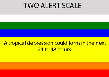
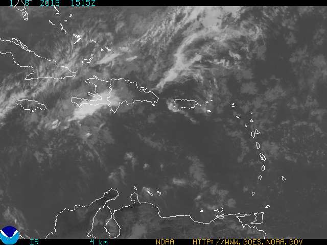
Re: INVEST 97L : Near Windward Islands : 5:30 PM TWO at page 14
You can see the shear zone to the west of 97L.
0 likes
-
jaxfladude
- Category 5
- Posts: 1249
- Joined: Wed Aug 24, 2005 9:36 pm
- Location: Jacksonville, Fla
Re: INVEST 97L : Near Windward Islands : 5:30 PM TWO at page 14
Karen Almost a certainty
Lorenzo Odds much in favor
Melissa 50-50
By Mid Oct. if not sooner
Lorenzo Odds much in favor
Melissa 50-50
By Mid Oct. if not sooner
0 likes
Re: INVEST 97L : Near Windward Islands : Discussions & Images
Ed Mahmoud wrote:Back in college in engineering classes, one got dinged for points if one gave more significant digits in a calculation than the accuracy of the coarsest measurement. Hence, estimating something like 25% or 50% or 75%, suggests to the user that there is a degree of uncertainty, while '52%' implies confidence.
I do understand that exact %'s usually mean confidence but I do that so it appears less chunky. I do it for fun and it can convey what my opinion is on a system without lots of writing. It also shows how my thinking goes from future strength.
0 likes
-
Tampa_God

- Category 1

- Posts: 333
- Age: 36
- Joined: Wed May 31, 2006 7:27 pm
- Location: New Port Richey/Trinity, FL
Re: INVEST 97L : Near Windward Islands : 5:30 PM TWO at page 14
If this does develop, it will most likely follow a movement towards Bermuda and then out to sea. Although it isn't looking good for any development tonight.
0 likes
Who is online
Users browsing this forum: No registered users and 42 guests