CAT 5 Hurricane Dean - Archived threads
Moderator: S2k Moderators
-
windstorm99

- S2K Supporter

- Posts: 1578
- Age: 48
- Joined: Sat May 26, 2007 8:10 am
- Location: Miami, Florida
- Contact:
Re: Major Hurricane DEAN: (11am p161) Discussions, Analysis
When and if dean gets in the gulf i'll be able to get some great satelitte views.
0 likes


Re: Major Hurricane DEAN: (11am p161) Discussions, Analysis
tolakram wrote:Question.
in this loop:
http://www.ssd.noaa.gov/goes/flt/t1/loop-vis.html
and in the link just posted you can see a blow off of convection, looks almost like an outflow boundry, heading NE. What exactly is that and what might cause it to happen?
There's a thin line of low-level cumulus that's expanding outward on the north side of the storm. That's likely an outflow boundary, sometimes created by evaporational cooling. If the air in that area is relatively dry, the some of the falling rain will evaporate, effectively cooling the air, leading an an outflow boundary. That matches up pretty well with the idea that there is a bit of dry air on the northern side (and to the north) of Dean.
A few things that I have found favorable for the past 2 days... The "scalloped" appearance to the outer edge of the cirrus shield on the periphery of the storm is a sign that I have often associated with a moderately- to rapidly-intensifying cyclone. Similarly, there are radially-oriented upper-level "streaks" that stretch outward from the center of the storm / near the eye. Again, this is something that I have associated with intensification. Finally, the appearance of a relatively small eye may argue for significant intensification. If we see a well-defined, fully-closed eye with a diameter of <5 miles, then I'll really start to harp on the Cat 4-5 potential relatively soon. Anecdotally, it seems that storms with large eyes tend to be relatively stable and not particularly intense (Cat 2-4). Sure, there are exceptions, but it seems like a large-diameter eye tends to accompany mature hurricanes with relatively stable intensities. Recon found a double eyewall structure, so we'll have to see where this stands in 12 hours.
FWIW, I don't think anyone is thinking of a Florida panhandle landfall. Personally, I would put the potential for a Florida landfall at about 5%. Well, below are my takes... Again, these are just my personal opinions/forecasts, and you use refer to the official forecasts for critical decisions (yada yada yada):
80% probability of eye hitting the Yucatan
20% probability of eye skirting to the east of the Yucatan
------------------------
Final landfall:
50% probability of making final landfall on mainland Mexico
35% probability of making final landfall on Texas coast
10% probability of making final landfall on Louisiana coast
<5% probability of making final landfall east of LA
Last edited by WxGuy1 on Fri Aug 17, 2007 2:57 pm, edited 1 time in total.
0 likes
-
weatherrabbit_tx

- Category 1

- Posts: 270
- Joined: Wed Dec 21, 2005 3:13 pm
- Location: Kingwood,Tx
- Contact:


-
windstorm99
- S2K Supporter
- Posts: 1578
- Age: 48
- Joined: Sat May 26, 2007 8:10 am
- Location: Miami, Florida
- Contact:
Re: Major Hurricane DEAN: (11am p161) Discussions, Analysis
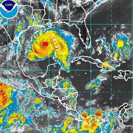
Visible loop of Major Hurricane Dean. 

Last edited by windstorm99 on Fri Aug 17, 2007 3:04 pm, edited 2 times in total.
0 likes
-
BayouVenteux

- S2K Supporter
- Posts: 775
- Age: 64
- Joined: Thu Sep 04, 2003 3:26 pm
- Location: Ascension Parish, Louisiana (30.3 N 91.0 W)
Re: Major Hurricane DEAN: (11am p161) Discussions, Analysis
chadtm80 wrote:Ignore the islands that are now in the gulf too though
Darn! The 2-day booze cruise from N.O. to St. Maarten would've been sweet!
0 likes


Re: Major Hurricane DEAN: (11am p161) Discussions, Analysis
CronkPSU wrote:wxfollower wrote:Has a cane ever turned where the models never indicated it would?
yes...off the top of my head, check out what all the models except GFDL said about katrina shortly before the Florida landfall but i am sure others will have much better examples especially when you get more than 3 days out
sometimes when a storm goes over or approaches a coast it can go in unpredicted directions due to coast or land interactions. For instance a possibility is that, depending on the angle at which Dean approaches the Yucatan and if part or all of it's eye goes over it, that there might be an interaction. The south side would be inhibited by the land and the wind would weaken there, while the north side which is over the water would be much stronger and perhaps even be blowing up as it crosses the Gulf Stream--this could cause the storm to take a brief northward jog that most of the models wouldn't predict. The WRF might though as it has a much more detailed land interaction understanding. Who knows though. I'm just randomly speculating. But I've seen the Yucatan do a lot of weird things to storms over the years--some just seemed to get sucked south into it after their center was over land for a while--when a storm is going as fast as Dean will be however, the effect will be smaller.
Last edited by vaffie on Fri Aug 17, 2007 3:01 pm, edited 1 time in total.
0 likes
-
Derek Ortt
Re: HR Dean: For any Island in the Carib that could be affected
http://www.cnn.com/2007/US/08/17/storms/index.html
contains Martinique news... major landslides apparently
contains Martinique news... major landslides apparently
0 likes

Re: Major Hurricane DEAN: (11am p161) Discussions, Analysis
thanks for posting that weatherguy - makes me rest easier for those in TX though I know it could always change.
0 likes
-
storms in NC

- S2K Supporter
- Posts: 2338
- Joined: Thu Jul 28, 2005 2:58 pm
- Location: Wallace,NC 40 miles NE of Wilm
- Contact:
-
Brent
- S2K Supporter
- Posts: 38737
- Age: 37
- Joined: Sun May 16, 2004 10:30 pm
- Location: Tulsa Oklahoma
- Contact:
Re: Major Hurricane DEAN: (11am p161) Discussions, Analysis
HurricaneGirl wrote::eek: Holy Crap!!

Where have you been?
Oh yeah, this is the first real hurricane since 2005, I get it now.
0 likes

Re: Major Hurricane DEAN: (11am p161) Discussions, Analysis
wxfollower wrote:Has a cane ever turned where the models never indicated it would?
More times than I can count..models are a guidance,that's all..getting better every year,but basically just a guide
0 likes
-
Brent
- S2K Supporter
- Posts: 38737
- Age: 37
- Joined: Sun May 16, 2004 10:30 pm
- Location: Tulsa Oklahoma
- Contact:
Re: Hurricane DEAN: Global Models
Extremeweatherguy wrote:I agree. I just do not see a powerful hurricane turning due west (or even WSW as the Euro shows) after reaching Jamaica. That just doesn't sound believable to me.Ivanhater wrote:The big key is around Jamaica...some models move it due west after Jamaica but the GFDL continues to feel a weakness in the ridge....as of now I dont see this moving due west right after Jamaica...but we will see
I agree as well, I think this weekend will be critical. North or south of Jamaica may make all the difference(I doubt it goes directly over, they RARELY do).
***IF*** it goes north, then this is obviously a U.S. final landfall.
0 likes
-
El Nino

- Category 1
- Posts: 454
- Age: 48
- Joined: Sun Oct 16, 2005 3:18 pm
- Location: Lima - Miraflores (Peru)
- Contact:
Re: Major Hurricane DEAN: (11am p161) Discussions, Analysis
chadtm80 wrote:NOT AN OFFICIAL MAP.. JUST A RENDERING. and a cheezy one at that
we were in chat and someone brought up that FNC was going to be imposing dean in the GOM to see what it would look like.. So whiped this up while in chat.. Ignore the islands that are now in the gulf too though
Not far from Katrina. In 4 days, it couldbe even bigger !
0 likes
-
ftolmsteen

- Tropical Storm

- Posts: 122
- Joined: Mon Jun 25, 2007 6:34 am
- Location: Port Richey, FL
Re: Major Hurricane DEAN: (11am p161) Discussions, Analysis
Dean is catching up to the ULL. The visible loop is showing mid/upper level clouds just a few hundred miles ahead of Dean heading northward towards the ULL.
0 likes
-
Weatherfreak14

- Category 5

- Posts: 1381
- Joined: Sat Sep 24, 2005 3:40 pm
- Location: Beaufort, SC
- Contact:
Re: Major Hurricane DEAN: (11am p161) Discussions, Analysis
WOW. i am in complete Aww right now...
0 likes
-
Aric Dunn
- Category 5
- Posts: 21238
- Age: 43
- Joined: Sun Sep 19, 2004 9:58 pm
- Location: Ready for the Chase.
- Contact:
Re: Major Hurricane DEAN: (11am p161) Discussions, Analysis
VERY NICE RADAR SHOT>>>
well defined eye .. the images will only get better as the day goes on , as the center gets just a little closer to the radar

If you look up there is a red dot west of the eye that is a buoy that is going to take a direct hit later tonight
well defined eye .. the images will only get better as the day goes on , as the center gets just a little closer to the radar
If you look up there is a red dot west of the eye that is a buoy that is going to take a direct hit later tonight
0 likes
-
Bailey1777
- S2K Supporter
- Posts: 962
- Joined: Mon Jul 31, 2006 6:23 pm
- Location: Houston, Texas
-
TreasureIslandFLGal

- S2K Supporter
- Posts: 1584
- Age: 58
- Joined: Sun Aug 15, 2004 6:16 pm
- Location: Cancun, Mexico (northeast Yucatan coast)
Re: Major Hurricane DEAN: (11am p161) Discussions, Analysis
I suspect a more significant model shift to those west proggin ones. Dean has not only kept up a fast clip throughout the day, but has also been heading slightly more north of the NHC's projected estimates.
0 likes
Who is online
Users browsing this forum: No registered users and 39 guests