Hurricane NOEL : Discussions & Images
Moderator: S2k Moderators

-
destruction92
- Category 1

- Posts: 312
- Joined: Sun Jul 22, 2007 10:43 pm
Re: Re:
wxman57 wrote:Tampa Bay Hurricane wrote:It looks like it is doing rapid intesification
with the cold cloud tops and will likely be a hurricane
by later today
I wouldn't assume that it's intensifying rapidly. In fact, convection appears to have been decreasing over the past few hours. What we know now is that this was most likely a TS overnight.
Now even more reason for Florida to feel better...Noel is probably going to dig itself a grave over Hispaniola....even if by some long shot Noel threatens Florida, it will be a sheared weakened system when it does.
Good news after good news for the U.S.
Bad news for Haiti though with flooding. At least they won't see any wind damage though.
0 likes
-
wxman57

- Moderator-Pro Met

- Posts: 23175
- Age: 68
- Joined: Sat Jun 21, 2003 8:06 pm
- Location: Houston, TX (southwest)
Re:
RL3AO wrote:The term "rapid intensification" is over used on here. RI is a drop of 42 mb in less than 24 hours. All Noel is doing is regular intensification.
Right, and we don't even know for sure that Noel is intensifying. It may have been stronger 6 hours ago when convection was more intense. It could be steady or weakening slightly now.
0 likes
-
CrazyC83
- Professional-Met

- Posts: 34315
- Joined: Tue Mar 07, 2006 11:57 pm
- Location: Deep South, for the first time!
URNT15 KNHC 281817
AF303 0116A CYCLONE1 HDOB 07 20071028
180430 1619N 07157W 9771 00193 9989 +245 +220 304015 015 029 000 00
180500 1618N 07158W 9766 00199 9991 +245 +220 300016 016 027 000 03
180530 1617N 07200W 9772 00194 9992 +244 +220 311020 023 030 000 00
180600 1616N 07201W 9771 00198 9995 +240 +220 316025 026 035 000 00
180630 1615N 07202W 9770 00201 9998 +239 +220 315027 028 035 000 00
180700 1614N 07203W 9771 00203 0001 +238 +220 313028 029 036 000 00
180730 1613N 07204W 9770 00207 0004 +238 +220 312028 029 035 000 00
180800 1612N 07205W 9771 00208 0006 +239 +220 314029 030 036 000 00
180830 1611N 07207W 9771 00209 0008 +240 +220 314028 029 036 000 00
180900 1610N 07208W 9770 00213 0010 +240 +220 316027 028 035 000 00
180930 1609N 07209W 9774 00212 0013 +240 +220 315026 027 035 000 00
181000 1608N 07210W 9762 00223 0015 +236 +220 319024 026 999 999 03
181030 1606N 07209W 9772 00215 0015 +236 +220 308023 024 027 000 03
181100 1606N 07207W 9772 00213 0013 +238 +220 302024 025 034 000 00
181130 1605N 07206W 9766 00217 0012 +231 +220 302027 027 036 000 00
181200 1605N 07204W 9772 00211 0010 +236 +220 295027 029 037 000 00
181230 1604N 07202W 9775 00207 0009 +240 +220 289026 027 036 000 00
181300 1604N 07200W 9773 00209 0009 +240 +220 284027 028 036 000 00
181330 1603N 07159W 9773 00208 0008 +243 +220 278028 028 036 000 00
181400 1603N 07157W 9772 00208 0007 +240 +220 275027 028 035 000 00
$$
0 likes
-
destruction92
- Category 1
- Posts: 312
- Joined: Sun Jul 22, 2007 10:43 pm
Re: Tropical Storm NOEL Models Thread
caneman wrote:cycloneye wrote:Code: Select all
TNT80 EGRR 281710


 MET OFFICE TROPICAL CYCLONE GUIDANCE FOR NORTH-EAST PACIFIC


 AND ATLANTIC


             GLOBAL MODEL DATA TIME 12UTC 28.10.2007


   TROPICAL DEPRESSION SIXTEEN    ANALYSED POSITION : 16.3N  72.3W


     ATCF IDENTIFIER : AL162007


  VERIFYING TIME     POSITION     STRENGTH        TENDENCY

  --------------     --------     --------        --------

 12UTC 28.10.2007  16.3N  72.3W   MODERATE

 00UTC 29.10.2007  16.7N  72.7W   MODERATE      LITTLE CHANGE

 12UTC 29.10.2007  17.3N  72.7W   MODERATE  INTENSIFYING SLIGHTLY

 00UTC 30.10.2007  19.8N  74.0W     WEAK      WEAKENING RAPIDLY

 12UTC 30.10.2007  21.3N  75.3W   MODERATE  INTENSIFYING RAPIDLY

 00UTC 31.10.2007  21.6N  78.0W     WEAK      WEAKENING RAPIDLY

 12UTC 31.10.2007  21.1N  79.1W     WEAK     WEAKENING SLIGHTLY

 00UTC 01.11.2007  21.7N  80.0W     WEAK        LITTLE CHANGE

 12UTC 01.11.2007  22.5N  80.5W     WEAK        LITTLE CHANGE

 00UTC 02.11.2007  23.2N  79.7W     WEAK    INTENSIFYING SLIGHTLY

 12UTC 02.11.2007  23.5N  80.4W     WEAK        LITTLE CHANGE

 00UTC 03.11.2007  23.5N  80.6W     WEAK     WEAKENING SLIGHTLY

 12UTC 03.11.2007  23.0N  79.8W     WEAK     WEAKENING SLIGHTLY
12z UKMET more west than GFDL but no South Florida landfall.
Still a very close call and can't be ruled out either.
Wait just there mister....click this link and explain the model output here.... http://www.wunderground.com/tropical/tr ... model.html
GFS and UKMET target the upper keys.
0 likes
-
CrazyC83
- Professional-Met
- Posts: 34315
- Joined: Tue Mar 07, 2006 11:57 pm
- Location: Deep South, for the first time!
URNT15 KNHC 281820
AF303 0116A CYCLONE1 HDOB 06 20071028
175430 1637N 07150W 9784 00167 9975 +245 +220 075013 016 028 000 03
175500 1636N 07150W 9789 00162 9972 +245 +220 054011 011 031 000 00
175530 1634N 07150W 9785 00165 9970 +245 +220 027009 009 029 000 00
175600 1633N 07150W 9785 00163 9970 +247 +220 355010 011 026 000 03
175630 1632N 07148W 9802 00144 9965 +250 +220 334007 008 028 000 03
175700 1633N 07147W 9804 00139 9961 +255 +220 350003 005 028 000 00
175730 1633N 07145W 9812 00129 9957 +255 +220 115004 007 026 000 00
175800 1633N 07144W 9776 00164 9957 +254 +220 158012 014 999 999 03
175830 1632N 07144W 9737 00193 9953 +253 +220 177006 010 028 000 03
175900 1631N 07145W 9783 00154 9957 +253 +220 283010 013 029 000 00
175930 1630N 07146W 9764 00174 9961 +251 +220 288015 016 031 000 00
180000 1629N 07147W 9771 00172 9966 +247 +220 288016 016 031 000 00
180030 1628N 07148W 9771 00176 9969 +248 +220 288016 016 029 000 00
180100 1627N 07150W 9773 00177 9972 +248 +220 293017 017 032 000 00
180130 1626N 07151W 9766 00185 9973 +246 +220 295016 017 029 000 00
180200 1625N 07152W 9773 00180 9976 +249 +220 295017 017 030 000 00
180230 1624N 07153W 9775 00181 9978 +250 +220 294016 017 030 000 00
180300 1623N 07154W 9771 00186 9981 +248 +220 300016 017 031 000 00
180330 1622N 07155W 9770 00190 9983 +246 +220 302016 017 031 000 00
180400 1620N 07156W 9775 00187 9986 +246 +220 304016 016 031 000 00
$$
;
The missed data set - 995mb pressure - center appears to be around 16.5°N, 71.8°W
0 likes
-
Evil Jeremy

- S2K Supporter

- Posts: 5463
- Age: 32
- Joined: Mon Apr 10, 2006 2:10 pm
- Location: Los Angeles, CA
Re: Tropical Storm Noel : Discussions & Images
Actually, the weaker the storm, the less north it will move, and the more Florida will be at risk. Is that right or is it the other way around?
0 likes
-
destruction92
- Category 1
- Posts: 312
- Joined: Sun Jul 22, 2007 10:43 pm
Re: Tropical Depression SIXTEEN : Discussions & Images
caneman wrote:And I would add that since this person is using WXMAN57's and Derek's name, perhaps they should step in and announce an all clear but I don't believe I've read that. And even if if they did, I wouldn't believe them as the margin of error is some 300 miles - 5 days out.
WXman57, any comments on what I and others have said....you've kind of bypassed responding to mine and Caneman's posts.
0 likes
-
CrazyC83
- Professional-Met
- Posts: 34315
- Joined: Tue Mar 07, 2006 11:57 pm
- Location: Deep South, for the first time!
Re:
HURAKAN wrote:The NHC has taken a long time to release the 2 PM advisory. They must have known that the RECON would find a TS.
They were writing a special advisory for about 2:15 pm - I think they were waiting for more flight information for specifics. I expect 50 mph winds and a 995mb pressure.
0 likes
-
Evil Jeremy
- S2K Supporter
- Posts: 5463
- Age: 32
- Joined: Mon Apr 10, 2006 2:10 pm
- Location: Los Angeles, CA
000
WTNT21 KNHC 281822
TCMAT1
TROPICAL STORM NOEL SPECIAL FORECAST/ADVISORY NUMBER 4
NWS TPC/NATIONAL HURRICANE CENTER MIAMI FL AL162007
1815 UTC SUN OCT 28 2007
A TROPICAL STORM WARNING REMAINS IN EFFECT FOR THE ENTIRE
SOUTHWESTERN PENINSULA OF HAITI FROM THE HAITI-DOMINICAN REPUBLIC
BORDER TO PORT-AU-PRINCE. A TROPICAL STORM WARNING IS ALSO
RECOMMENDED FOR THE SOUTHWESTERN DOMINICAN REPUBLIC FROM BARAHONA
WESTWARD.
A TROPICAL STORM WATCH REMAINS IN EFFECT FOR PORTIONS OF
SOUTHEASTERN CUBA IN THE PROVINCES OF GRANMA...SANTIAGO DE
CUBA...AND GUANTANAMO. A TROPICAL STORM WATCH IS ALSO IN EFFECT
FOR JAMAICA.
TROPICAL STORM CENTER LOCATED NEAR 16.5N 71.8W AT 28/1815Z
POSITION ACCURATE WITHIN 30 NM
PRESENT MOVEMENT TOWARD THE NORTH-NORTHWEST OR 330 DEGREES AT 4 KT
ESTIMATED MINIMUM CENTRAL PRESSURE 996 MB
MAX SUSTAINED WINDS 45 KT WITH GUSTS TO 45 KT.
34 KT.......100NE 0SE 0SW 75NW.
12 FT SEAS..100NE 90SE 0SW 75NW.
WINDS AND SEAS VARY GREATLY IN EACH QUADRANT. RADII IN NAUTICAL
MILES ARE THE LARGEST RADII EXPECTED ANYWHERE IN THAT QUADRANT.
REPEAT...CENTER LOCATED NEAR 16.5N 71.8W AT 28/1815Z
AT 28/1200Z CENTER WAS LOCATED NEAR 16.4N 71.6W
FORECAST VALID 29/0000Z 17.6N 72.7W
MAX WIND 50 KT...GUSTS 60 KT.
50 KT... 50NE 0SE 0SW 50NW.
34 KT...100NE 0SE 0SW 100NW.
FORECAST VALID 29/1200Z 18.7N 74.2W
MAX WIND 55 KT...GUSTS 65 KT.
50 KT... 50NE 0SE 0SW 50NW.
34 KT...100NE 0SE 0SW 100NW.
FORECAST VALID 30/0000Z 19.9N 75.5W
MAX WIND 60 KT...GUSTS 75 KT.
50 KT... 50NE 50SE 0SW 50NW.
34 KT...100NE 100SE 0SW 100NW.
FORECAST VALID 30/1200Z 21.1N 76.6W...INLAND
MAX WIND 50 KT...GUSTS 60 KT.
50 KT... 50NE 50SE 0SW 50NW.
34 KT...100NE 100SE 0SW 100NW.
FORECAST VALID 31/1200Z 22.5N 77.5W
MAX WIND 55 KT...GUSTS 65 KT.
50 KT... 50NE 50SE 25SW 50NW.
34 KT...100NE 100SE 50SW 100NW.
EXTENDED OUTLOOK. NOTE...ERRORS FOR TRACK HAVE AVERAGED NEAR 225 NM
ON DAY 4 AND 300 NM ON DAY 5...AND FOR INTENSITY NEAR 20 KT EACH DAY
OUTLOOK VALID 01/1200Z 23.5N 77.5W
MAX WIND 55 KT...GUSTS 65 KT.
OUTLOOK VALID 02/1200Z 25.5N 75.5W
MAX WIND 50 KT...GUSTS 60 KT.
REQUEST FOR 3 HOURLY SHIP REPORTS WITHIN 300 MILES OF 16.5N 71.8W
NEXT ADVISORY AT 28/2100Z
$$
FORECASTER KNABB
0 likes
-
HURAKAN

- Professional-Met
- Posts: 46084
- Age: 39
- Joined: Thu May 20, 2004 4:34 pm
- Location: Key West, FL
- Contact:
435
WTNT21 KNHC 281822
TCMAT1
TROPICAL STORM NOEL SPECIAL FORECAST/ADVISORY NUMBER 4
NWS TPC/NATIONAL HURRICANE CENTER MIAMI FL AL162007
1815 UTC SUN OCT 28 2007
A TROPICAL STORM WARNING REMAINS IN EFFECT FOR THE ENTIRE
SOUTHWESTERN PENINSULA OF HAITI FROM THE HAITI-DOMINICAN REPUBLIC
BORDER TO PORT-AU-PRINCE. A TROPICAL STORM WARNING IS ALSO
RECOMMENDED FOR THE SOUTHWESTERN DOMINICAN REPUBLIC FROM BARAHONA
WESTWARD.
A TROPICAL STORM WATCH REMAINS IN EFFECT FOR PORTIONS OF
SOUTHEASTERN CUBA IN THE PROVINCES OF GRANMA...SANTIAGO DE
CUBA...AND GUANTANAMO. A TROPICAL STORM WATCH IS ALSO IN EFFECT
FOR JAMAICA.
TROPICAL STORM CENTER LOCATED NEAR 16.5N 71.8W AT 28/1815Z
POSITION ACCURATE WITHIN 30 NM
PRESENT MOVEMENT TOWARD THE NORTH-NORTHWEST OR 330 DEGREES AT 4 KT
ESTIMATED MINIMUM CENTRAL PRESSURE 996 MB
MAX SUSTAINED WINDS 45 KT WITH GUSTS TO 45 KT.
34 KT.......100NE 0SE 0SW 75NW.
12 FT SEAS..100NE 90SE 0SW 75NW.
WINDS AND SEAS VARY GREATLY IN EACH QUADRANT. RADII IN NAUTICAL
MILES ARE THE LARGEST RADII EXPECTED ANYWHERE IN THAT QUADRANT.
REPEAT...CENTER LOCATED NEAR 16.5N 71.8W AT 28/1815Z
AT 28/1200Z CENTER WAS LOCATED NEAR 16.4N 71.6W
FORECAST VALID 29/0000Z 17.6N 72.7W
MAX WIND 50 KT...GUSTS 60 KT.
50 KT... 50NE 0SE 0SW 50NW.
34 KT...100NE 0SE 0SW 100NW.
FORECAST VALID 29/1200Z 18.7N 74.2W
MAX WIND 55 KT...GUSTS 65 KT.
50 KT... 50NE 0SE 0SW 50NW.
34 KT...100NE 0SE 0SW 100NW.
FORECAST VALID 30/0000Z 19.9N 75.5W
MAX WIND 60 KT...GUSTS 75 KT.
50 KT... 50NE 50SE 0SW 50NW.
34 KT...100NE 100SE 0SW 100NW.
FORECAST VALID 30/1200Z 21.1N 76.6W...INLAND
MAX WIND 50 KT...GUSTS 60 KT.
50 KT... 50NE 50SE 0SW 50NW.
34 KT...100NE 100SE 0SW 100NW.
FORECAST VALID 31/1200Z 22.5N 77.5W
MAX WIND 55 KT...GUSTS 65 KT.
50 KT... 50NE 50SE 25SW 50NW.
34 KT...100NE 100SE 50SW 100NW.
EXTENDED OUTLOOK. NOTE...ERRORS FOR TRACK HAVE AVERAGED NEAR 225 NM
ON DAY 4 AND 300 NM ON DAY 5...AND FOR INTENSITY NEAR 20 KT EACH DAY
OUTLOOK VALID 01/1200Z 23.5N 77.5W
MAX WIND 55 KT...GUSTS 65 KT.
OUTLOOK VALID 02/1200Z 25.5N 75.5W
MAX WIND 50 KT...GUSTS 60 KT.
REQUEST FOR 3 HOURLY SHIP REPORTS WITHIN 300 MILES OF 16.5N 71.8W
NEXT ADVISORY AT 28/2100Z
$$
FORECASTER KNABB
0 likes
-
cycloneye

- Admin

- Posts: 149596
- Age: 69
- Joined: Thu Oct 10, 2002 10:54 am
- Location: San Juan, Puerto Rico
Re: Tropical Storm Noel : Discussions & Images
destruction92 ,as I said before,please calm down.You have your points and others have other views.Lets have a dialougue in a smooth manner and all with be fine with the discussions.
0 likes


Re: Tropical Storm Noel : Discussions & Images
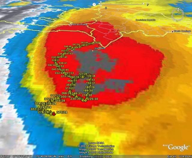
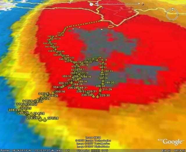
Now that we know where the center probably is from recon, it doesn't appear it's been making the sharp turn to the NW as it looked earlier this morning. I think the center reformed a little ENE of the old one. The convection made it look closer to Hispanola, but it's really on the southern edge. It looks like it's resumed a WNW motion on latest visible loops.
0 likes
-
CrazyC83
- Professional-Met
- Posts: 34315
- Joined: Tue Mar 07, 2006 11:57 pm
- Location: Deep South, for the first time!
URNT15 KNHC 281827
AF303 0116A CYCLONE1 HDOB 08 20071028
181430 1602N 07155W 9769 00211 0006 +240 +220 268026 028 035 000 00
181500 1602N 07153W 9768 00210 0006 +241 +220 265028 029 036 000 00
181530 1601N 07151W 9770 00208 0006 +244 +220 264029 030 036 000 00
181600 1601N 07150W 9771 00207 0006 +245 +220 263028 029 035 000 00
181630 1600N 07148W 9769 00210 0005 +246 +220 263029 029 037 000 00
181700 1600N 07146W 9772 00207 0006 +245 +220 261029 029 036 000 00
181730 1559N 07144W 9771 00208 0007 +240 +220 255028 029 036 000 00
181800 1559N 07142W 9770 00210 0007 +239 +220 256027 028 034 000 03
181830 1600N 07141W 9778 00203 0007 +238 +220 249027 028 031 000 03
181900 1600N 07139W 9771 00209 0007 +238 +220 248027 029 035 000 03
181930 1600N 07137W 9773 00208 0007 +244 +220 245026 027 034 000 00
182000 1600N 07136W 9767 00213 0007 +244 +220 246027 027 035 000 00
182030 1600N 07134W 9774 00207 0008 +239 +220 243025 026 033 000 00
182100 1600N 07132W 9766 00216 0009 +240 +220 240024 025 033 000 00
182130 1600N 07130W 9770 00212 0009 +244 +220 238025 026 035 000 00
182200 1600N 07128W 9770 00212 0009 +245 +220 237026 026 035 000 00
182230 1600N 07127W 9772 00211 0009 +245 +220 233025 026 036 000 00
182300 1600N 07125W 9771 00211 0010 +245 +220 232024 024 034 000 03
182330 1601N 07124W 9766 00216 0010 +245 +220 225024 024 999 999 03
182400 1602N 07124W 9775 00206 0009 +245 +220 222022 023 033 000 03
$$
0 likes

Re: Tropical Storm Noel : Discussions & Images
Updated guidance in line with CMC/GFDL/HWRF
Will remain well east of Florida. Looks like the US made it through '07
Will remain well east of Florida. Looks like the US made it through '07
0 likes
-
destruction92
- Category 1
- Posts: 312
- Joined: Sun Jul 22, 2007 10:43 pm
Re: Tropical Storm Noel : Discussions & Images
cycloneye wrote:destruction92 ,as I said before,please calm down.You have your points and others have other views.Lets have a dialougue in a smooth manner and all with be fine with the discussions.
We are having a "smooth" dialogue. What's the problem in asking Wxman57 for his opinion? I am sure others are curious to know as well. He has not made anymore comments for a looong time on Noel's track.
0 likes
Who is online
Users browsing this forum: No registered users and 48 guests