TD INGRID: Discussions & Images - Last Advisory
Moderator: S2k Moderators
-
Derek Ortt
-
Ed Mahmoud
Re:
Derek Ortt wrote:NOAA is deploying to Barbados for a flight in 48 hours.
One can fly out to about 45W from Barbados (would only get a couple of hours in the storm like some of the Felix flights from St Croix though)
Did the Orion that got roughed up in Felix get a clean bill of health?
0 likes
Re: Invest 91L,East of Windwards: Discussions & Images
[quote="jdjaguar]
and jax dude..is this "our" year? lets hope not..its been 43 years since Dora...[/quote]
Maybe any one of this systems (Cat 1 to 5 Hurricanes that is) could be the next one after Dora (XX years since)
I've lived in Jax for a long time..and you're right..the backdoor canes have been the ones to hit...(though big bad Floyd gave us a scare)...for some reason canes don't make that left hook up here..but tend to hug the coast and hit Savannah or Charleston.[/quote]
Some direct hurricane landfalls on NE FL 9/15-10/5:
I found seven: 9/22/1599, 9/30/1707, ~9/25/1769, 9/15/1806, 10/4-5/1811, 9/16-7/1813, and 10/2/1825.
(10/2/1898: eye was just north of NE FL at Cumberland Island.)
I found only five direct hurricane landfalls in NE FL outside of the dates 9/15-10/5 (all earlier dates). Therefore, one could perhaps argue that 9/15-10/5 is the prime risk period. Assuming 91-L develops and doesn't recurve, its slow speed means it COULD approach the SE coast around 9/19-22, which is during "prime-time" for NE FL. With the modeled pattern for that period being conducive to a tropical threat along the SE coast imho around that period (big surface highs in or offshore the NE US/upper level ridging eastern U.S.), SE U.S. coastal residents, including those in NE FL, should pay close attention to what 91-L does.
0 likes
-
Derek Ortt
Re: Invest 91L,East of Windwards: Discussions & Images
LarryWx wrote:[
nice research...
Believe me, I am paying very close attention....especially to how close 91-L skirts the northern leewards...that is key (in my limited experience of watching these storms) for a ECFL threat.
regards.
0 likes
San Juan NWS thinks this will be in the eastern carribean this weekend 
000
FXCA62 TJSJ 111916
AFDSJU
AREA FORECAST DISCUSSION
NATIONAL WEATHER SERVICE SAN JUAN PR
316 PM AST TUE SEP 11 2007
.SYNOPSIS...
TUTT LOW SOUTH OF HISPANIOLA AND THE WINDWARD PASSAGE WILL CONTINUE
TO SHIFT FURTHER WEST THROUGH THURSDAY...AS UPPER HIGH PRESSURE
RIDGE BUILDS FURTHER WESTWARDS FROM THE TROPICAL ATLANTIC. AS A
RESULT...THE PREVAILING UPPER LEVEL SOUTHERLY WIND FLOW WILL BECOME
WESTERLY BY THURSDAY THEN CONTINUE THROUGH FRIDAY. A 1021 MB HIGH
CENTERED NEAR BERMUDA WILL SHIFT EAST NORTHEAST THROUGH THURSDAY...
MAINTAINING A MODERATE TO FRESH TRADE WIND FLOW ACROSS THE REGIONAL
WATERS. A TROPICAL WAVE NEAR 69 WEST WITH AXIS EXTENDING NORTHWARD
ACROSS THE DOMINICAN REPUBLIC...WILL CONTINUE TO MOVE FURTHER WEST
AND AWAY FROM THE LOCAL REGION OVERNIGHT. AN AREA OF LOW PRESSURE
AND ASSOCIATED TROPICAL WAVE NEAR 41 WEST WILL APPROACH THE LESSER
ANTILLES LATE FRIDAY...THEN ENTER THE EASTERN CARIBBEAN ON
SATURDAY MORNING...AND MOVE ACROSS THE REGIONAL WATERS
SATURDAY THROUGH SUNDAY.
0 likes
Re: 91L,E of Windwards: Discussions=10:30 PM TWO at page 41
Like Felix, this one fooled us that it might not develop and then spun up.
Makes no difference, I think we are looking at an interesting track hurricane.
Makes no difference, I think we are looking at an interesting track hurricane.
0 likes
-
fasterdisaster
- Category 5

- Posts: 1868
- Joined: Mon Sep 19, 2005 4:41 pm
- Location: Miami, Florida
Re: 91L,E of Windwards: Discussions=10:30 PM TWO at page 41
Exact dates of FORMATION (TD+) for the 45 1851-2006 CV storms* that later hit the contiguous U.S:
7/5, 7/11, 7/15, 7/31, 8/3, 8/3, 8/5, 8/7, 8/7, 8/15, 8/15, 8/16, 8/16, 8/17, 8/17, 8/18, 8/19, 8/20, 8/20, 8/21, 8/23, 8/25, 8/25, 8/27, 8/28, 8/28, 8/29, 8/29, 9/2, 9/3, 9/4, 9/6, 9/6, 9/7, 9/8, 9/10, 9/10, 9/10, 9/10, 9/11, 9/15, 9/16, 9/21, 9/21, 9/25
*My def. of CV storm: tropical storm/hurricane that first became at least a TD E of 50W and S of 20N
So, with tomorrow already being 9/12, it is getting pretty late for a CV storm to form and hit the lower 48. However, with 9/12 being only barely past the 9/10 peak and with 91-L having a good chance to become a TD on 9/12, it is one to watch carefully considering the modeled pattern for next week.
Last edited by LarryWx on Tue Sep 11, 2007 10:03 pm, edited 1 time in total.
0 likes
- HurricaneMaster_PR
- Category 2

- Posts: 795
- Joined: Tue Jul 22, 2003 6:23 pm
- Location: San Juan, Puerto Rico
Re: 91L,E of Windwards: Discussions=10:30 PM TWO at page 41
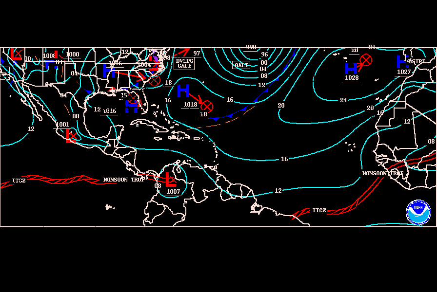
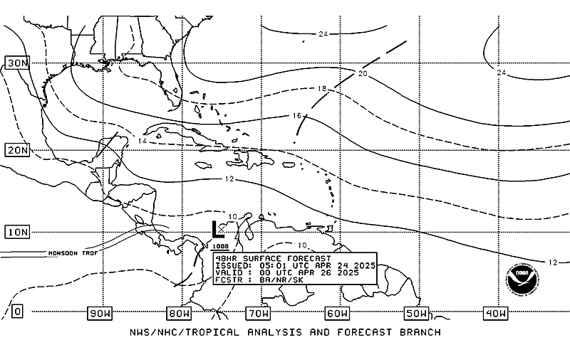
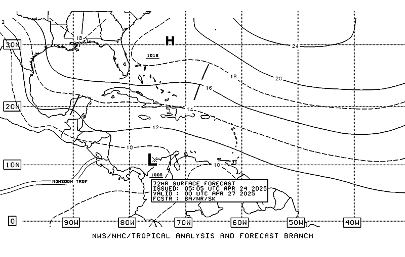
TPC insists in a movement toward the west to west-northwest according to TAFB 00Z Surface Forecast and 00Z Surface Analysis Chart
00Z Surface Analysis Chart

48 hours

72 hours

00Z Surface Analysis Chart

48 hours

72 hours

0 likes
- Extremeweatherguy
- Category 5

- Posts: 11095
- Joined: Mon Oct 10, 2005 8:13 pm
- Location: Florida
For anyone interested, here is a look at a few memorable storms to have skimmed or passed just north of the islands...
Frances (2004) = http://weather.unisys.com/hurricane/atl ... /track.gif
Georges (1998) = http://weather.unisys.com/hurricane/atl ... /track.gif
Bertha (1996) = http://weather.unisys.com/hurricane/atl ... /track.gif
Luis (1995) = http://weather.unisys.com/hurricane/atl ... /track.gif
Hugo (1989) = http://weather.unisys.com/hurricane/atl ... /track.gif
Claudette (1979) = http://weather.unisys.com/hurricane/atl ... /track.gif
Frederic (1979) = http://weather.unisys.com/hurricane/atl ... /track.gif
Eloise (1975) = http://weather.unisys.com/hurricane/atl ... /track.gif
Betsy (1965) = http://weather.unisys.com/hurricane/atl ... /track.gif
Donna (1960) = http://weather.unisys.com/hurricane/atl ... /track.gif
Hilda (1955) = http://weather.unisys.com/hurricane/atl ... /track.gif
Ione (1955) = http://weather.unisys.com/hurricane/atl ... /track.gif
Edna (1954) = http://weather.unisys.com/hurricane/atl ... /track.gif
Baker (1950) = http://weather.unisys.com/hurricane/atl ... /track.gif
#2 (1949) = http://weather.unisys.com/hurricane/atl ... /track.gif
#9 (1945) = http://weather.unisys.com/hurricane/atl ... /track.gif
#5 (1933) = http://weather.unisys.com/hurricane/atl ... /track.gif
#11 (1933) = http://weather.unisys.com/hurricane/atl ... /track.gif
#12 (1933) = http://weather.unisys.com/hurricane/atl ... /track.gif
#4 (1928) = http://weather.unisys.com/hurricane/atl ... /track.gif
#6 (1926) = http://weather.unisys.com/hurricane/atl ... /track.gif
#2 (1915) = http://weather.unisys.com/hurricane/atl ... /track.gif
#1 a.k.a. The Galveston Hurricane (1900) = http://weather.unisys.com/hurricane/atl ... /track.gif
Last edited by Extremeweatherguy on Tue Sep 11, 2007 10:30 pm, edited 3 times in total.
0 likes
- Extremeweatherguy
- Category 5

- Posts: 11095
- Joined: Mon Oct 10, 2005 8:13 pm
- Location: Florida
Re: Invest 91L,East of Windwards: Discussions & Images
I knew I was bound to miss one! lol. Thanks for pointing that out.Fego wrote:ummm Hugo (1989)????
0 likes
- gatorcane
- S2K Supporter

- Posts: 23703
- Age: 47
- Joined: Sun Mar 13, 2005 3:54 pm
- Location: Boca Raton, FL
Re: Invest 91L,East of Windwards: Discussions & Images
you missed a very important one:
That was 60 years ago this coming week that South Florida was gearing up for this potent monster that caused massive flooding in Palm Beach County, Florida.
The great 1947 Lake Okeechobie Hurricane. It looks like 91L has a chance of taking a similar track at least up north of the Big Islands.
4 Hurricane #4 4-21 SEP 140 947 5
A CAT 5 monster.
If you look at the track notice how far south it got in the MDR before it started WNW as this system is doing...

Last edited by gatorcane on Tue Sep 11, 2007 10:53 pm, edited 3 times in total.
0 likes
GFS 9/12 00z rolling in...
Thru Hr 54 a just north of due west motion
http://www.nco.ncep.noaa.gov/pmb/nwprod ... n_054l.gif
Thru Hr 54 a just north of due west motion
http://www.nco.ncep.noaa.gov/pmb/nwprod ... n_054l.gif
0 likes
- HurricaneMaster_PR
- Category 2

- Posts: 795
- Joined: Tue Jul 22, 2003 6:23 pm
- Location: San Juan, Puerto Rico
Re:
Vortex wrote:GFS 9/12 00z rolling in...
Thru Hr 54 a just north of due west motion
http://www.nco.ncep.noaa.gov/pmb/nwprod ... n_054l.gif
This run, as yesterday's run at 00Z, is not good as it put the system stationary for a couple of days!
Last edited by HurricaneMaster_PR on Tue Sep 11, 2007 11:04 pm, edited 1 time in total.
0 likes
Re: Re:
HurricaneMaster_PR wrote:Vortex wrote:GFS 9/12 00z rolling in...
Thru Hr 54 a just north of due west motion
http://www.nco.ncep.noaa.gov/pmb/nwprod ... n_054l.gif
This run, as yesterday's run at 00Z, is not good as the system is stationary for a couple of days!
yeah, this one smells bad.....opens it up around the islands at 90hrs.....
0 likes
Who is online
Users browsing this forum: No registered users and 55 guests


