Looks like TD11 some time tomorrow to me also.
Any pros want to chime in and shoot a prediction?
I see Derek says don't count on it so soon.
TD INGRID: Discussions & Images - Last Advisory
Moderator: S2k Moderators
-
Matt-hurricanewatcher
Re: Invest 91L,East of Windwards: Discussions & Images
AZRainman wrote:Looks like TD11 some time tomorrow to me also.
Any pros want to chime in and shoot a prediction?
I see Derek says don't count on it so soon.
I say as soon as the nhc wents to upgrade it. Also more likely once the visible is in. But it would be td8.
0 likes
-
AZRainman

- Tropical Storm

- Posts: 146
- Joined: Fri Sep 23, 2005 12:48 pm
- Location: Sonoran Desert
- Contact:
Re: Invest 91L,East of Windwards: Discussions & Images
Matt-hurricanewatcher wrote:I say as soon as the nhc wents to upgrade it. Also more likely once the visible is in. But it would be td8.
Egads what a miscount, that's what I get for seeing what I saw on Master's blog and believing it was factual. Live and learn, thanks
Still going with a td by tomorrow
0 likes
-
caneman
Re: Invest 91L,East of Windwards: Discussions & Images
The 2:00 NHC discusssion would seem to support both an established low and one that could be upgraded at any time. Far more organized than the naysayers would have you believe. Snippet
A SLOW MOVING BROAD AREA OF LOW PRES ABOUT 1000 NM E OF THE
LESSER ANTILLES IS SHOWING SINGS OF ORGANIZING THIS MORNING.
THIS LOW WAS ANALYZED 1010 MB NEAR 13N43W...ALTHOUGH BUOY 41041
COULD SUGGEST A SLIGHTLY LOWER MINIMUM PRESSURE. SATELLITE
IMAGERY SHOWS A CONSOLIDATING AND INCREASINGLY CIRCULAR MASS OF
CLOUDS ASSOCIATED WITH THIS SYSTEM. THE LOW-LEVEL CENTER IS
DIFFICULT TO PIN DOWN EXACTLY ALTHOUGH IT APPEARS TO BE
PARTIALLY TUCKED UNDER THE CLOUDINESS NEAR THE ERN EDGE OF
SCATTERED MODERATE CONVECTION FROM 11N-14N BETWEEN 43W-46W.
CONDITIONS APPEAR FAVORABLE FOR THIS SYSTEM TO DEVELOP INTO A
TROPICAL DEPRESSION WITHIN THE NEXT DAY OR SO AS IT MOVES SLOWLY
WEST-NORTHWESTWARD.
$$
CANGIALOSI
0 likes
-
Coredesat
-
Matt-hurricanewatcher
Re: Invest 91L,East of Windwards: Discussions & Images
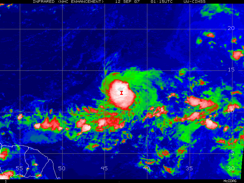
LLC at 12.8/43.2 moving west-northwestward...Before the satellite black out there was a broad LLC, but since the new satellite is in. It appears to be rotating around one LLC near the placement above....You can easly see the edge of the LLC on the eastern side. 95 percent is under the convection. I think the next quickscat will show a much more defined and maybe some 30 knot winds.
0 likes
-
Meso

- Category 5

- Posts: 1609
- Age: 39
- Joined: Mon Aug 09, 2004 12:14 pm
- Location: South Africa
- Contact:

First visibles starting
AN AREA OF LOW PRESSURE IS LOCATED ABOUT 1150 MILES EAST OF THE
WINDWARD ISLANDS. THIS SYSTEM CONTINUES TO BECOME BETTER
ORGANIZED...AND CONDITIONS APPEAR FAVORABLE FOR A TROPICAL
DEPRESSION TO FORM LATER TODAY OR TONIGHT AS THE SYSTEM MOVES WEST-
NORTHWESTWARD AROUND 10 MPH.
FORECASTER MAINELLI
Last edited by Meso on Wed Sep 12, 2007 4:21 am, edited 1 time in total.
0 likes
-
cycloneye

- Admin

- Posts: 149298
- Age: 69
- Joined: Thu Oct 10, 2002 10:54 am
- Location: San Juan, Puerto Rico
Re: Invest 91L,East of Windwards: Discussions & Images
ABNT20 KNHC 120920
TWOAT
TROPICAL WEATHER OUTLOOK
NWS TPC/NATIONAL HURRICANE CENTER MIAMI FL
530 AM EDT WED SEP 12 2007
FOR THE NORTH ATLANTIC...CARIBBEAN SEA AND THE GULF OF MEXICO...
AN AREA OF LOW PRESSURE IS LOCATED ABOUT 1150 MILES EAST OF THE
WINDWARD ISLANDS. THIS SYSTEM CONTINUES TO BECOME BETTER
ORGANIZED...AND CONDITIONS APPEAR FAVORABLE FOR A TROPICAL
DEPRESSION TO FORM LATER TODAY OR TONIGHT AS THE SYSTEM MOVES WEST-
NORTHWESTWARD AROUND 10 MPH.
AN AREA OF LOW PRESSURE IS LOCATED OVER THE NORTHWESTERN GULF OF
MEXICO. SHOWERS AND THUNDERSTORMS ASSOCIATED WITH THE LOW HAVE
INCREASED EARLY THIS MORNING AND ARE SPREADING ACROSS PORTIONS OF
THE TEXAS COAST. ENVIRONMENTAL CONDITIONS APPEAR TO BE CONDUCIVE
FOR SOME DEVELOPMENT OF THIS SYSTEM OVER THE NEXT DAY OR SO AS IT
DRIFTS SLOWLY WEST-NORTHWESTWARD OVER THE NEXT DAY OR TWO.
ELSEWHERE...TROPICAL CYCLONE FORMATION IS NOT EXPECTED DURING THE
NEXT 48 HOURS.
$$
FORECASTER MAINELLI
0 likes
-
AJC3

- Admin
- Posts: 4153
- Age: 62
- Joined: Tue Aug 31, 2004 7:04 pm
- Location: Ballston Spa, New York
- Contact:
Re: Invest 91L,East of Windwards: Discussions & Images
Timely 0849Z TRMM pass. 91L looks impressive, though it appears that the system is tilted westward with height.
http://www.nrlmry.navy.mil/htdocs_dyn/t ... W.63pc.jpg
http://www.nrlmry.navy.mil/htdocs_dyn/t ... W.63pc.jpg
http://www.nrlmry.navy.mil/htdocs_dyn/t ... W.63pc.jpg
http://www.nrlmry.navy.mil/htdocs_dyn/t ... W.63pc.jpg
http://www.nrlmry.navy.mil/htdocs_dyn/t ... W.63pc.jpg
http://www.nrlmry.navy.mil/htdocs_dyn/t ... W.63pc.jpg
0 likes

Re: Invest 91L,East of Windwards: Discussions & Images
AJC3 wrote:Timely 0849Z TRMM pass. 91L looks impressive, though it appears that the system is tilted westward with height.
http://www.nrlmry.navy.mil/htdocs_dyn/t ... W.63pc.jpg
http://www.nrlmry.navy.mil/htdocs_dyn/t ... W.63pc.jpg
http://www.nrlmry.navy.mil/htdocs_dyn/t ... W.63pc.jpg
I agree it does look impressive. If there is a closed LLC it would probably be around 13N and 43W, from looking at those images. QS pass later this morning should catch this system and confirm if the LLC is closed this time.
0 likes


Re: Invest 91L,East of Windwards: Discussions & Images
The convection has been persistant and all the models seem to be in agreement about a slow WNW motion. NHC will probably upgrade this morning.
The GFS has a huge blocking ridge over extending over the southeastern US at 144 hours. The trough is forecast to lift out in four days would not be able to pick this system up.
If we get a faster westward motion once the ridge develops over the southeastern states it will change the timing for the next steering trough. A trough could save Texas from a second landfall for example.
Last edited by Nimbus on Wed Sep 12, 2007 5:35 am, edited 1 time in total.
0 likes
-
Typhoon_Willie

- Category 5
- Posts: 1042
- Joined: Mon Jun 09, 2003 3:19 pm
- Location: Greenacres City, Florida
Re: Invest 91L,East of Windwards: Discussions & Images
Looks good on this first visible loop!
0 likes
-
cycloneye
- Admin
- Posts: 149298
- Age: 69
- Joined: Thu Oct 10, 2002 10:54 am
- Location: San Juan, Puerto Rico
Re: Invest 91L,East of Windwards: Discussions & Images
[bWTNT01 KNGU 120900z
SUBJ/TROPICAL CYCLONE FORMATION ALERT 120900Z SEP 07//
RMKS/1. FORMATION OF A TROPICAL CYCLONE IS POSSIBLE
WITHIN 100NM EITHER SIDE OF A LINE FROM 12N 42W TO
14N 46W WITHIN THE NEXT 24 HOURS. AVAILABLE DATA DOES
NOT JUSTIFY ISSUANCE OF A NUMBERED TROPICAL CYCLONE
WARNING AT THIS TIME.
2. AN AREA OF LOW PRESSURE WITH AN ESTIMATED CENTRAL
PRESSURE OF 1010MB IS LOCATED APPROX 1000NM EAST OF THE
LESSER ANTILIES NEAR 13N 43W. MOVEMENT IS WEST-NORTHWEST
AT NEAR 6 KNOTS. THIS SYSTEM REMAINS OVER WARM SEA SURFACE
TEMPERATURES AND UPPER LEVER WINDS DISPLAY DIVERGENCE IN THE
WINDS FIELD. ENVIRONMENTAL CONDITIONS ARE EXPECTED TO BECOME
MORE FAVORABLE OVER THE NEXT 24 HOURS FOR FURTHER DEVELOPMENT
FOR THIS SYSTEM.
3. THIS ALERT WILL BE REISSUED, ALLOWED TO EXPIRE, OR CANCELLED
BY 130900Z SEP 2007.//
][/b]
Tropical Cyclone Formation Alert issued.
0 likes
-
AJC3
- Admin
- Posts: 4153
- Age: 62
- Joined: Tue Aug 31, 2004 7:04 pm
- Location: Ballston Spa, New York
- Contact:
Re: Invest 91L,East of Windwards: Discussions & Images
Nimbus wrote:The convection has been persistant and all the models seem to be in agreement about a slow WNW motion. NHC will probably upgrade this morning.
The GFS has a huge blocking ridge over the sotheastern US at 144 hours. The trough is forecast to lift out in four days would not be able to pick this system up.
If we get a faster westward motion once the ridge develops over the southeastern states it will change the timing for the next steering trough. A trough could save Texas from a second landfall for example.
The GFS shows no such thing as a blocking ridge over the southeast U.S. at H144 (although there is a large upper high over the lower MS valley/gulf coast). And while there is a large high at the surface, between days 5 (120 hours) and 7 (168 hours) the GFS shows a large cutoff 500MB low developing just offshore the east coast of the United States and dropping southward to just offshore the east coast of Florida. If a solution close to the 00Z/06Z GFS or the 00Z ECM comes to pass, should there be a TC north of the GA in 5 to 6 days, it would start to turn northward to the east of the low.
Being that far out, no model solution should be taken verbatim.
0 likes
-
Cookiely

- S2K Supporter

- Posts: 3211
- Age: 75
- Joined: Fri Aug 13, 2004 7:31 am
- Location: Tampa, Florida
Re: 91L,East of Windwards: Discussions=TCFA at page 44
Does 91L seem unusually large for a disturbance?
0 likes
-
destruction92
- Category 1

- Posts: 312
- Joined: Sun Jul 22, 2007 10:43 pm
Re: Invest 91L,East of Windwards: Discussions & Images
AJC3 wrote:Nimbus wrote:The convection has been persistant and all the models seem to be in agreement about a slow WNW motion. NHC will probably upgrade this morning.
The GFS has a huge blocking ridge over the sotheastern US at 144 hours. The trough is forecast to lift out in four days would not be able to pick this system up.
If we get a faster westward motion once the ridge develops over the southeastern states it will change the timing for the next steering trough. A trough could save Texas from a second landfall for example.
The GFS shows no such thing as a blocking ridge over the southeast U.S. at H144 (although there is a large upper high over the lower MS valley/gulf coast). And while there is a large high at the surface, between days 5 (120 hours) and 7 (168 hours) the GFS shows a large cutoff 500MB low developing just offshore the east coast of the United States and dropping southward to just offshore the east coast of Florida. If a solution close to the 00Z/06Z GFS or the 00Z ECM comes to pass, should there be a TC north of the GA in 5 to 6 days, it would start to turn northward to the east of the low.
Being that far out, no model solution should be taken verbatim.
I guess that does it for now! A pro-met suggesting that there should be a weakness to steer 92L northward. Very encouraging news for the East Coast...but still eary.
By the way, does the ECMWF also suggest a weakness in the ridge as the GFS does...if I remember correctly, yesterday it was showing a steering pattern that would suggest a Bahama and possibly FL threat.
0 likes


-
destruction92
- Category 1
- Posts: 312
- Joined: Sun Jul 22, 2007 10:43 pm
Re:
HURAKAN wrote:Latest:
Continues to look amazing. Depression at 11 AM, no questions asked.
Depression at 8AM...AND DON'T YOU DARE ASK A QUESTION!
0 likes
Who is online
Users browsing this forum: No registered users and 24 guests