


NWPAC: 台风“浣熊” STS Neoguri (0801/02W)
Moderator: S2k Moderators


Re:
Chacor wrote:Unfortunately twister at ohio state is down so I don't have the latest JMA fix.
http://weather.noaa.gov/pub/data/raw/wt ... .rjtd..txt
WTPQ20 RJTD 152100
RSMC TROPICAL CYCLONE ADVISORY
NAME TS 0801 NEOGURI (0801)
ANALYSIS
PSTN 152100UTC 12.9N 113.9E GOOD
MOVE NNW 12KT
PRES 992HPA
MXWD 045KT
GUST 065KT
30KT 200NM NORTH 180NM SOUTH
FORECAST
24HF 162100UTC 15.6N 111.9E 80NM 70%
MOVE NW 08KT
PRES 985HPA
MXWD 050KT
GUST 070KT
45HF 171800UTC 16.8N 111.0E 150NM 70%
MOVE NW 06KT
PRES 980HPA
MXWD 055KT
GUST 080KT
69HF 181800UTC 18.5N 110.0E 220NM 70%
MOVE NNW 06KT
PRES 980HPA
MXWD 055KT
GUST 080KT =
0 likes


-
Matt-hurricanewatcher
Re: NWPAC: 热带风暴“浣熊” TS Neoguri (0801/02W)
Eyewall appears to be forming, so around 60 knots is my guest.
0 likes

-
Derek Ortt
-
Typhoon Hunter
- WesternPacificWeather.com

- Posts: 1222
- Joined: Wed Oct 11, 2006 11:37 am
- Location: Tokyo
- Contact:
Re: NWPAC: 热带风暴“浣熊” TS Neoguri (0801/02W)
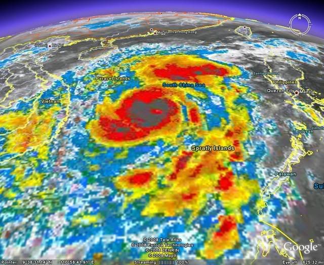
The storm is really looking beautiful. JMA have now upgraded Neoguri to severe tropical storm strength with sustained winds of 50kts. Hainan Island looks like the bull's eye at the moment.
WTPQ20 RJTD 160000
RSMC TROPICAL CYCLONE ADVISORY
NAME STS 0801 NEOGURI (0801) UPGRADED FROM TS
ANALYSIS
PSTN 160000UTC 13.1N 113.0E GOOD
MOVE NW 12KT
PRES 985HPA
MXWD 050KT
GUST 070KT
30KT 200NM
FORECAST
24HF 170000UTC 15.8N 111.6E 90NM 70%
MOVE NNW 08KT
PRES 980HPA
MXWD 055KT
GUST 080KT
48HF 180000UTC 16.8N 111.1E 150NM 70%
MOVE NNW SLOWLY
PRES 975HPA
MXWD 060KT
GUST 085KT
72HF 190000UTC 18.9N 110.6E 220NM 70%
MOVE N SLOWLY
PRES 980HPA
MXWD 055KT
GUST 080KT =
0 likes
-
Typhoon Hunter
- WesternPacificWeather.com
- Posts: 1222
- Joined: Wed Oct 11, 2006 11:37 am
- Location: Tokyo
- Contact:
Re: NWPAC: 热带风暴“浣熊” TS Neoguri (0801/02W)
http://www.goes.noaa.gov/sohemi/SHGMSCOLW.JPG
Ummm is that what I think it is poking through in the middle in the image above?
Ummm is that what I think it is poking through in the middle in the image above?
0 likes


Who is online
Users browsing this forum: Google Adsense [Bot] and 50 guests