ATL: Tropical Depression Fay
Moderator: S2k Moderators


-
wxman57

- Moderator-Pro Met

- Posts: 23172
- Age: 68
- Joined: Sat Jun 21, 2003 8:06 pm
- Location: Houston, TX (southwest)
Re: ATL: Invest 92L - Central Atlantic
Blown_away wrote:
Wow, forgot how pretty Frances was out at sea, she wasn't pretty when she was pounding my town. So Wxman57, is the setup appear to be similar?
Here's a 500mb streamline forecast for next Sunday that sort of matches the position of Frances on the other link I posted. Setup is very similar. One significant difference is the much deeper trof over the eastern U.S. next weekend than there was when Frances was approaching.
0 likes


-
GeneratorPower

- S2K Supporter

- Posts: 1648
- Age: 46
- Joined: Sun Dec 18, 2005 11:48 pm
- Location: Huntsville, AL
Re:
coreyl wrote:Will 92L go out to sea?
Not very likely given the current setup. It will likely at least affect the islands. It may or may not recurve to the east after that but chances are pretty good it would affect someone while in the process of recurving.
0 likes
-
Derek Ortt
-
JonathanBelles
- Professional-Met

- Posts: 11430
- Age: 35
- Joined: Sat Dec 24, 2005 9:00 pm
- Location: School: Florida State University (Tallahassee, FL) Home: St. Petersburg, Florida
- Contact:
-
Blown Away

- S2K Supporter
- Posts: 10253
- Joined: Wed May 26, 2004 6:17 am
Re: ATL: Invest 92L - Central Atlantic
wxman57 wrote:Blown_away wrote:Wow, forgot how pretty Frances was out at sea, she wasn't pretty when she was pounding my town. So Wxman57, is the setup appear to be similar?
Here's a 500mb streamline forecast for next Sunday that sort of matches the position of Frances on the other link I posted. Setup is very similar. One significant difference is the much deeper trof over the eastern U.S. next weekend than there was when Frances was approaching.
So a deeper trough should give 92L a better chance to miss at least SFL? Isn't the ridge suppose to be building to the W and the trough moving W away from the EC about that time?
0 likes
-
curtadams
- S2K Supporter
- Posts: 1122
- Joined: Sun Aug 28, 2005 7:57 pm
- Location: Orange, California
- Contact:
Re: ATL: Invest 92L - Central Atlantic
Quickscat and RGB both show a large, loose COC (possibly multiple centers on RGB). It's like Dolly that way. Heading down towards Dmin so that's not likely to change today during daytime. I don't expect an NHC upgrade until tomorrow (although I'd call it a depression myself).
0 likes
-
bvigal

- S2K Supporter
- Posts: 2276
- Joined: Sun Jul 24, 2005 8:49 am
- Location: British Virgin Islands
- Contact:
Re: ATL: Invest 92L - Central Atlantic
Maybe it is a bit soon, from the standpoint of not enough data yet, and persistance. On the other hand, from 8am TWD: "THE TROPICAL WAVE ALONG 41W S OF 19N IS MOVING W NEAR 15 KT. IR SATELLITE IMAGERY EXHIBITS A CYCLONIC TURNING OBSERVED ALONG THE WAVE AXIS NEAR 11N. AN EARLIER SCATTEROMETER PASS AT 0840Z CONFIRMS POSITION OF THE WAVE ALONG WITH A POSSIBLE CLOSED LOW CIRCULATION FORMING ALONG THE WAVE AXIS. " is still true, and "...CONVECTIVE ACTIVITY ASSOCIATED WITH THIS WAVE REMAINS DISORGANIZED..." no longer appears true. Originally, the circulation was not under the bulk of convection, but now is. The other factor is proximity to U.S. islands. At any rate, I hope this isn't one of those they have to put a plane in to confirm a closed low, and we wait 2 days until it's almost on our doorstep (meaning the Eastern Caribbean) before they declare it!!!Mecklenburg wrote:bvigal wrote:Hurakan, glad you posted that dvorak. I've been running the loop, and I think we'll have a depression in another hour.
http://www.ssd.noaa.gov/goes/flt/t1/loop-bd.html
so soon?
0 likes

Re: ATL: Invest 92L - Central Atlantic
With the NRL sat and GE, I'm looking at 11N 44*30'W for a low center. Is that anywhere near close now anyone think?
0 likes

Re: ATL: Invest 92L - Central Atlantic
http://www.ndbc.noaa.gov/maps/Caribbean.shtml
bUOY 41041 SHOULD BE WATCHALTHOUGH A BIT TO THE NORTH OF THE CENTER???
bUOY 41041 SHOULD BE WATCHALTHOUGH A BIT TO THE NORTH OF THE CENTER???
0 likes

-
tolakram
- Admin

- Posts: 20179
- Age: 62
- Joined: Sun Aug 27, 2006 8:23 pm
- Location: Florence, KY (name is Mark)
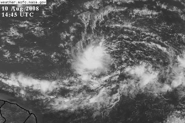
Re: ATL: Invest 92L - Central Atlantic
Personal Forecast Disclaimer:
The posts in this forum are NOT official forecast and should not be used as such. They are just the opinion of the poster and may or may not be backed by sound meteorological data. They are NOT endorsed by any professional institution or storm2k.org. For official information, please refer to the NHC and NWS products.
I'm thinking a good chance for a TD later today. Looking at both the visible and IR the convection is not only persistent but steady and the visible shows the circulation becoming more vigorous.
0 likes
-
cheezyWXguy

- Category 5

- Posts: 6281
- Joined: Mon Feb 13, 2006 12:29 am
- Location: Dallas, TX
Re: ATL: Invest 92L - Central Atlantic
tolakram wrote:Personal Forecast Disclaimer:
The posts in this forum are NOT official forecast and should not be used as such. They are just the opinion of the poster and may or may not be backed by sound meteorological data. They are NOT endorsed by any professional institution or storm2k.org. For official information, please refer to the NHC and NWS products.
I'm thinking a good chance for a TD later today. Looking at both the visible and IR the convection is not only persistent but steady and the visible shows the circulation becoming more vigorous.
I dunno...convection is persistent, but somewhat disorganized. In addition the circulation is elongated, despite being nearly closed. But compared yesterday its an incredible improvement, and development appears likely out of this one. I do believe it will take at least a day though for that circulation to become less elongated, Masters says 2 days.
0 likes
Who is online
Users browsing this forum: No registered users and 26 guests