ATL: Tropical Storm Kyle : Discussion

Moderator: S2k Moderators

Message
Author
User avatar
cycloneye
Admin
Admin
Posts: 143863
Age: 68
Joined: Thu Oct 10, 2002 10:54 am
Location: San Juan, Puerto Rico

Re: ATL INVEST 93L: Discussion

#101 Postby cycloneye » Fri Sep 19, 2008 6:45 pm

235
ABNT20 KNHC 192340
TWOAT
TROPICAL WEATHER OUTLOOK
NWS TPC/NATIONAL HURRICANE CENTER MIAMI FL
800 PM EDT FRI SEP 19 2008

FOR THE NORTH ATLANTIC...CARIBBEAN SEA AND THE GULF OF MEXICO...

:rarrow: A WESTWARD-MOVING TROPICAL WAVE...ACCOMPANIED BY A BROAD SURFACE LOW
PRESSURE SYSTEM OVER THE SOUTHEASTERN CARIBBEAN SEA...IS PRODUCING
WIDESPREAD CLOUDINESS AND SHOWERS OVER THE LESSER ANTILLES...AND
ADJACENT CARIBBEAN AND ATLANTIC WATERS. THIS SYSTEM HAS CHANGED
LITTLE IN ORGANIZATION DURING THE PAST SEVERAL HOURS. WHILE
UPPER-LEVEL WINDS ARE CURRENTLY UNFAVORABLE...THEY ARE EXPECTED TO
BECOME MORE CONDUCIVE FOR SOME DEVELOPMENT TO OCCUR OVER THE NEXT
COUPLE OF DAYS.

A BROAD AREA OF LOW PRESSURE...ACCOMPANIED BY DISORGANIZED SHOWER
ACTIVITY...HAS FORMED OVER THE WESTERN CARIBBEAN SEA JUST EAST OF
HONDURAS-NICARAGUA BORDER. UPPER-LEVEL WINDS ARE CURRENTLY NOT
FAVORABLE FOR ADDITIONAL DEVELOPMENT.

ELSEWHERE...TROPICAL CYCLONE FORMATION IS NOT EXPECTED DURING THE
NEXT 48 HOURS.

$$
FORECASTER BEVEN
0 likes   

User avatar
msbee
S2K Supporter
S2K Supporter
Posts: 3027
Joined: Wed Jun 11, 2003 10:11 am
Location: St. Maarten

Re: ATL INVEST 93L: Discussion

#102 Postby msbee » Fri Sep 19, 2008 6:50 pm

Gustywind wrote:
msbee wrote:gusty
I hope you guys don't get too much from this system. take care down there.
I think..I hope..that this thing is far enough south of us that we will just get some showers but nothing too heavy. Our met office says we have a chance of a few locally heavy showers.
it's windy here and we have had a few moderate showers today.
PR? watch out, Luis.
and DR and Haiti..OH God, I hope not..those poor people have enough to deal with already.

Tkanks a lot, i appreciate :). Very moist here and grey with numerous clouds but no rain, winds.
Hope nothing to bad but we should experience maybe consequent amounts of water tonight or tommorow morning givent the latest weather forecast , let's see how the things evolve. I hope that the strong showers will not race near your location Msbee, seems that this little boy is gaining convecction by the hour.Furthemore, have you ever seen the other "little" perturbed area behind this little boy,? Developpement or not of these two systems could bring very unstelled conditions maybe 3 days more to the East Carib if this is confirmed, waouw :eek: !


I did see the area behind 93L. Sunday is InterCoastal Cleanup day here. we have over 400 volunteers ready to go to clean up one of our beaches. it's a big event and I fear we will get rained out.
we'll see.
0 likes   

jlauderdal
S2K Supporter
S2K Supporter
Posts: 7177
Joined: Wed May 19, 2004 5:46 am
Location: NE Fort Lauderdale
Contact:

Re: ATL INVEST 93L: Discussion

#103 Postby jlauderdal » Fri Sep 19, 2008 7:04 pm

wxman57 wrote:
jlauderdal wrote:
Ed Mahmoud wrote:Maybe conditions will improve for development, but despite lots of convection, this looks like a mess to my amateur eyes.


and thus its still an invest


Looks like a mess to my eyes, too. Little or no convection within several hundred miles of a weak low-level spin. Didn't understand Jeff Masters' statement that he thought it had a 30-60% chance of developing into a depression at one part then a 60% chance of becoming a depression farther down. I think 30% is too high.

its a mess and thats why its an invest and nothing more, i agree that masters is too bullish especially considering the shear outlook the next day or so, oh well maybe he is bored
0 likes   

User avatar
cycloneye
Admin
Admin
Posts: 143863
Age: 68
Joined: Thu Oct 10, 2002 10:54 am
Location: San Juan, Puerto Rico

Re: ATL INVEST 93L: Discussion

#104 Postby cycloneye » Fri Sep 19, 2008 7:38 pm

00:00 UTC Best track update:

AL, 93, 2008092000, , BEST, 0, 139N, 648W, 25, 1008, LO,
0 likes   

User avatar
terrapintransit
Category 1
Category 1
Posts: 275
Age: 50
Joined: Tue Sep 04, 2007 8:08 pm
Location: Williamsport, Pa

Re: ATL INVEST 93L: Discussion

#105 Postby terrapintransit » Fri Sep 19, 2008 7:43 pm

Image
0 likes   

User avatar
Gustywind
Category 5
Category 5
Posts: 12334
Joined: Mon Sep 03, 2007 7:29 am
Location: Baie-Mahault, GUADELOUPE

#106 Postby Gustywind » Fri Sep 19, 2008 7:46 pm

Not good news in ST Vincent given by a correspondant of the island:
http://stormcarib.com/reports/current/stvincent.shtml
- Updates from the Islands -
- - St.Vincent & Grenadines - -
- Update from St Vincent
From: "Haniff Sutherland" <hanniff at gmail.com>
Date: Fri, 19 Sep 2008 20:21:58 -0400

All,

St Vincent continues to be affected by this system, I have just learnt that some person(s) may have been covered and possibly died as a result of the land slide in the Jacks wall at Ratho Mill, it did not make the evening news, but I am quite sure I would have known those persons, as we are a very closely connected community.As I get more info, I will continue to post, attached is a pic from one of the swollen rivers this morning.

Improve your online presence, get a domain name for yourself or your company, only $9.95 per year.

http://www.iwantmydomain.com

Attachment: IMG00371.jpg
Description: JPEG image
0 likes   

User avatar
Gustywind
Category 5
Category 5
Posts: 12334
Joined: Mon Sep 03, 2007 7:29 am
Location: Baie-Mahault, GUADELOUPE

#107 Postby Gustywind » Fri Sep 19, 2008 7:53 pm

000
AXNT20 KNHC 192357
TWDAT

TROPICAL WEATHER DISCUSSION
NWS TPC/NATIONAL HURRICANE CENTER MIAMI FL
805 PM EDT FRI SEP 19 2008

TROPICAL WEATHER DISCUSSION FOR NORTH AMERICA...CENTRAL
AMERICA...GULF OF MEXICO...CARIBBEAN SEA...NORTHERN SECTIONS
OF SOUTH AMERICA...AND ATLANTIC OCEAN TO THE AFRICAN COAST
FROM THE EQUATOR TO 32N. THE FOLLOWING INFORMATION IS BASED
ON SATELLITE IMAGERY...METEOROLOGICAL ANALYSIS...WEATHER
OBSERVATIONS...AND RADAR.

BASED ON 1800 UTC SURFACE ANALYSIS AND SATELLITE IMAGERY THROUGH
2315 UTC.

...TROPICAL WAVES...

A TROPICAL WAVE...ACCOMPANIED BY A BROAD SURFACE LOW PRESSURE
SYSTEM...CONTINUES TO PRODUCE WIDESPREAD CLOUDINESS AND SHOWERS
OVER THE LESSER ANTILLES...AND ADJACENT CARIBBEAN AND ATLANTIC
WATERS. ITS AXIS IS ALONG 63W SOUTH OF 19N MOVING SLOWLY WWD.
THIS SYSTEM HAS BECOME A LITTLE BETTER ORGANIZED TODAY...AND
ALTHOUGH UPPER-LEVEL WINDS ARE CURRENTLY UNFAVORABLE...THEY ARE
EXPECTED TO BECOME MORE CONDUCIVE FOR SOME ADDITIONAL
DEVELOPMENT TO OCCUR OVER THE NEXT COUPLE OF DAYS.
CARIBBEAN SEA...
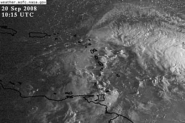
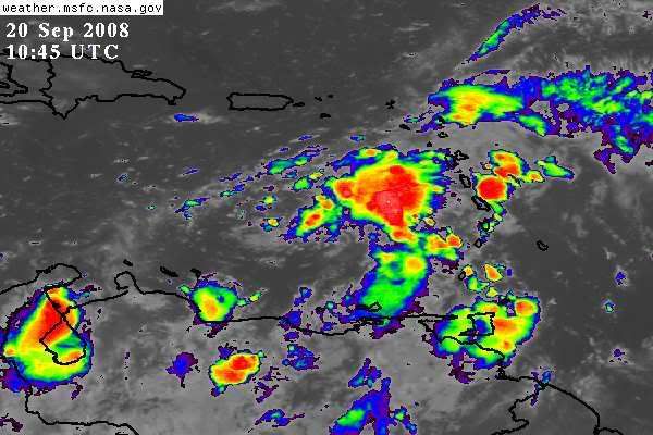
ATTENTION REMAINS FOCUSED ON THE ACTIVE TROPICAL WAVE LOCATED
OVER THE EASTERN CARIBBEAN THAT IS PRODUCING WIDESPREAD
CLOUDINESS AND SHOWERS OVER THE LESSER ANTILLES AND ADJACENT
CARIBBEAN AND ATLANTIC WATERS. CLUSTERS OF MODERATE TO ISOLATED
STRONG CONVECTION COVER THE AREA FROM 11N-18N BETWEEN 56W-61W
MORE CONCENTRATED N OF 14N. MOISTURE AHEAD OF THE WAVE AXIS HAS
ALREADY REACHED THE UK/US VIRGIN ISLANDS WITH THE SAN JUAN
DOPPLER RADAR SHOWING SCATTERED TO NUMEROUS SHOWERS WITH
EMBEDDED TSTMS MOVING WWD ACROSS THESE ISLANDS. THE GFS COMPUTER
MODEL HAS THE DEEP TROPICAL MOISTURE ASSOCIATED WITH THIS WAVE
SPREADING OVER THESE ISLANDS AND THE EASTERN CARIBBEAN LATE
TONIGHT INTO SATURDAY...AND OVER DOMINICAN REPUBLIC ON SUNDAY
AS THE WAVE CONTINUES TO MOVE SLOWLY WWD.


New guests are ready for a party?
ATLANTIC OCEAN...
A PAIR OF TROPICAL WAVES ARE MOVING WWD ACROSS THE TROPICAL ATLC...AND A NEW ONE APPEARS TO MOVE OFF THE WEST
AFRICAN COAST :roll: :?:
0 likes   

User avatar
KatDaddy
Category 5
Category 5
Posts: 2815
Joined: Mon Oct 21, 2002 6:23 pm
Location: League City, Texas

#108 Postby KatDaddy » Fri Sep 19, 2008 8:51 pm

The party is over in TX. It ended abruptly when the power went out Friday about 9:30 PM. Thanks goodness for unsecured wireless routers in the neighborhood. Still no cable 6 days later.
0 likes   

User avatar
wxman57
Moderator-Pro Met
Moderator-Pro Met
Posts: 22951
Age: 67
Joined: Sat Jun 21, 2003 8:06 pm
Location: Houston, TX (southwest)

Re:

#109 Postby wxman57 » Fri Sep 19, 2008 9:13 pm

KatDaddy wrote:The party is over in TX. It ended abruptly when the power went out Friday about 9:30 PM. Thanks goodness for unsecured wireless routers in the neighborhood. Still no cable 6 days later.


Thunderstorms are now 300-500 miles east of the weak LLC. Not much to this disturbance now. Better chance of dissipating than developing.

I'm connected through my neighbor's wireless network, though he is letting me. Power out here at the house but is on 2 houses down now.
0 likes   

HurricaneFreak

Re: ATL INVEST 93L: Discussion

#110 Postby HurricaneFreak » Fri Sep 19, 2008 9:13 pm

http://www.ssd.noaa.gov/goes/flt/t1/loop-vis.html
It looks like the circulation and llc is wrapping around but on the east antilles but they said the low is west in the carribean already ?that what it shows on this storm2k map
0 likes   

User avatar
KatDaddy
Category 5
Category 5
Posts: 2815
Joined: Mon Oct 21, 2002 6:23 pm
Location: League City, Texas

#111 Postby KatDaddy » Fri Sep 19, 2008 9:25 pm

I want to thank you WXMan for a great job 0f keeping us all informed. Its very much appreciated.
0 likes   

MiamiensisWx

Re: Re:

#112 Postby MiamiensisWx » Fri Sep 19, 2008 9:28 pm

wxman57 wrote:Thunderstorms are now 300-500 miles east of the weak LLC. Not much to this disturbance now. Better chance of dissipating than developing.

I'm connected through my neighbor's wireless network, though he is letting me. Power out here at the house but is on 2 houses down now.

On another note, what was your final verification on Ike in regards to track/intensity performance? I apologize for the brief OT tangent, but would be extremely convenient if professional meteorologists, met students, and informed amateurs could compile forecast verifications (or a general summary/overview of the forecasts and analyses) for individual events. Obviously, your company's specifications may preclude a public in-depth review, but a brief, succinct post (i.e. "I did fair/average/excellent/etc.") may be viable. Assessments of accuracy and average errors are important for posterity. Of course, this is not critique... I'm always curious in regards to the final outcomes of the forecasts posted by meteorologists/other contributors here and elsewhere.

If it is not possible, I'll rescind my suggestions...

In any case, thanks in advance. Your input is certainly appreciated.
Last edited by MiamiensisWx on Fri Sep 19, 2008 9:49 pm, edited 5 times in total.
0 likes   

User avatar
Gustywind
Category 5
Category 5
Posts: 12334
Joined: Mon Sep 03, 2007 7:29 am
Location: Baie-Mahault, GUADELOUPE

#113 Postby Gustywind » Fri Sep 19, 2008 9:40 pm

ORANGE alert is confirmed tonight for Guadeloupe.
Given the latest weather prediction at 9PM by Meteo-France:

The active area is located just slightly south and East of Guadeloupe. During the night numerous pockets of active weather will bring heavy showers locally intense. Thunder could be heared, under the strong squalls gustywinds can be at 33 kts and much more.
Let's see if this night will not be to difficult here, hope nothing to bad only water, but this system is pretty nasty and suspicious, we should not let our guard down.... :roll:
0 likes   

Sanibel
Category 5
Category 5
Posts: 10375
Joined: Mon Aug 30, 2004 11:06 pm
Location: Offshore SW Florida

Re: ATL INVEST 93L: Discussion

#114 Postby Sanibel » Fri Sep 19, 2008 11:27 pm

This thinning of convection could be another Dolly-like deep d-min. This is a weird pattern this year that I couldn't guess a scientific reason for. This will prove true if this latest center dot of convection bursts into a cold top center. Surprised people aren't seeing this weird phenomenon.
0 likes   

jlauderdal
S2K Supporter
S2K Supporter
Posts: 7177
Joined: Wed May 19, 2004 5:46 am
Location: NE Fort Lauderdale
Contact:

Re: ATL INVEST 93L: Discussion

#115 Postby jlauderdal » Sat Sep 20, 2008 4:08 am

ZCZC MIATWOAT ALL
TTAA00 KNHC DDHHMM
TROPICAL WEATHER OUTLOOK
NWS TPC/NATIONAL HURRICANE CENTER MIAMI FL
200 AM EDT SAT SEP 20 2008

FOR THE NORTH ATLANTIC...CARIBBEAN SEA AND THE GULF OF MEXICO...

1. A WESTWARD-MOVING TROPICAL WAVE...ACCOMPANIED BY A BROAD SURFACE LOW
PRESSURE SYSTEM OVER THE SOUTHEASTERN CARIBBEAN SEA...IS PRODUCING
WIDESPREAD CLOUDINESS AND SHOWERS OVER THE LESSER ANTILLES...AND
ADJACENT CARIBBEAN AND ATLANTIC WATERS. THIS SYSTEM HAS CHANGED
LITTLE IN ORGANIZATION DURING THE PAST SEVERAL HOURS. WHILE
UPPER-LEVEL WINDS ARE CURRENTLY UNFAVORABLE...THEY ARE EXPECTED TO
BECOME MORE CONDUCIVE FOR SOME DEVELOPMENT TO OCCUR OVER THE NEXT
COUPLE OF DAYS.

2. A BROAD AREA OF LOW PRESSURE...ACCOMPANIED BY DISORGANIZED SHOWER
ACTIVITY...CONTINUES OVER THE WESTERN CARIBBEAN SEA JUST EAST OF THE
HONDURAS-NICARAGUA BORDER. UPPER-LEVEL WINDS ARE CURRENTLY NOT
FAVORABLE FOR ADDITIONAL DEVELOPMENT.

ELSEWHERE...TROPICAL CYCLONE FORMATION IS NOT EXPECTED DURING THE
NEXT 48 HOURS.

$$
FORECASTER BEVEN
0 likes   

bob rulz
Category 5
Category 5
Posts: 1703
Age: 35
Joined: Sat Jan 28, 2006 7:30 pm
Location: Salt Lake City, Utah

#116 Postby bob rulz » Sat Sep 20, 2008 4:18 am

We have to remember that it's still September people...things may have been calm (in terms of formation at least) for a couple of weeks, but the season is far from over.
0 likes   

User avatar
abajan
S2K Supporter
S2K Supporter
Posts: 4229
Joined: Sun Sep 07, 2003 5:10 am
Location: Barbados

Re: ATL INVEST 93L: Discussion

#117 Postby abajan » Sat Sep 20, 2008 4:44 am

Gustywind, it looks like a ball of deep convection is headed your way from the southwest. Enjoy it! :lol:
0 likes   

User avatar
HURAKAN
Professional-Met
Professional-Met
Posts: 46086
Age: 38
Joined: Thu May 20, 2004 4:34 pm
Location: Key West, FL
Contact:

#118 Postby HURAKAN » Sat Sep 20, 2008 5:35 am

Image

More convection near the center.
0 likes   

User avatar
HURAKAN
Professional-Met
Professional-Met
Posts: 46086
Age: 38
Joined: Thu May 20, 2004 4:34 pm
Location: Key West, FL
Contact:

#119 Postby HURAKAN » Sat Sep 20, 2008 5:43 am

Image
0 likes   

User avatar
HURAKAN
Professional-Met
Professional-Met
Posts: 46086
Age: 38
Joined: Thu May 20, 2004 4:34 pm
Location: Key West, FL
Contact:

#120 Postby HURAKAN » Sat Sep 20, 2008 6:10 am

Image

I have to say. Looking better today.
0 likes   


Return to “2008”

Who is online

Users browsing this forum: No registered users and 31 guests