ATL: Tropical Depression Edouard
Moderator: S2k Moderators


Re: ATL: Tropical Storm Edouard - Gulf of Mexico
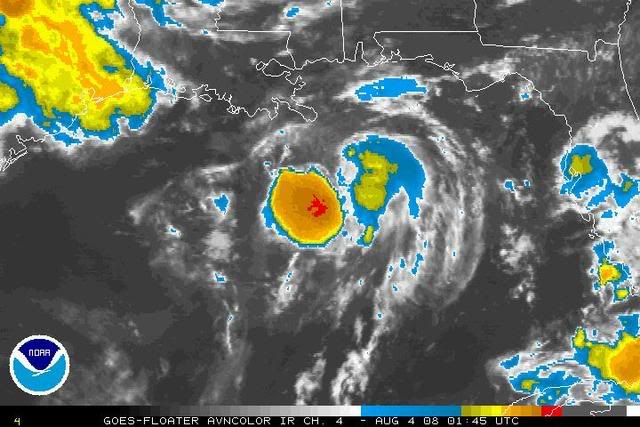
The large convective blob to the southwest of the center is beginning to wrap around. By 11 pm central time, it should be wrapped around. At that point, we could see some rapid development towards morning.
0 likes
-
fasterdisaster
- Category 5

- Posts: 1868
- Joined: Mon Sep 19, 2005 4:41 pm
- Location: Miami, Florida
Re: ATL: Tropical Storm Edouard - Gulf of Mexico
HouTXmetro wrote:
I understand, but that doesn't help if the center is almost naked right? Don't we need convection over the LLC for strengthening?
Short answer: No.
0 likes
-
MiamiensisWx
Re: ATL: Tropical Storm Edouard - Gulf of Mexico
MiamiensisWx wrote:I thought it would be interesting to mention this tidbit.
Here is the current mid level shear streamline analysis from CIMSS:
http://img379.imageshack.us/img379/4809/edouardmlshearaug3081hm6.png
Note the upper low and associated TUTT over the NW Caribbean that is currently located very close to Edouard. Yesterday, it was further from the system and enhanced ventilation/divergence and outflow. However, it has moved much closer, while Edouard has been very lethargic. I can't recall any TC that intensified beyond (marginal?) Category 1 intensity with an upper low so close to the SE of the TC. In fact, many analogous TCs in this type of situation did not exceed TS status. On the other hand, if the upper low is further SE (away from the TC) or SW of the system like Dolly and other cases, the TCs have tended to attain greater intensities (i.e. strong Cat 1+, as opposed to low end Cat 1 or weaker). Does anyone believe there is some support for this theory?
If support exists, the following explanation may describe the reasoning(s).
In a situation like Edouard, the upper air pattern to the NW and as a whole tends to be more "convoluted" and suspect to potentially unfavorable thermodynamic/synoptic factors. For instance, in this situation, there is typically a mid/upper level ridge NW of the TC that is also inducing northerly shear like the upper low immediately SE of the TC. In addition, these situations often feature mid level dry air from the North American continent, which is typical with many homegrown GOM TCs that develop via a broad surface trough. There is often a departing shortwave or surface front that leaves dry air in its wake, stabilizing the boundary layer to the south for certain time periods. Finally, the outflow from Mesoscale Convective Systems rotating around the ridge and overland convection often shears budding TCs.
Another factor is that this type of pattern (at the mid/upper levels) may reflect a less progressive pattern across the CONUS, unlike Dolly.
Does anyone else (professional meteorologists?) see my point?
Anyway, I'm sticking to my original belief that this one will not exceed solid/strong TS status.
Bump... this one may have been left unanswered on the bottom of the preceding page.
0 likes
-
Ed Mahmoud
Re: ATL: Tropical Storm Edouard - Gulf of Mexico
fasterdisaster wrote:HouTXmetro wrote:
I understand, but that doesn't help if the center is almost naked right? Don't we need convection over the LLC for strengthening?
Short answer: No.
I'm not sure you are correct. Besides not being able to think of a mechanism for evacuating air from the surface and lowering pressure in substantial quantities without storms in a non baroclinic system, I can't recall any naked swirl TCs that strengthened while naked.
Some have maintained with comvection nearby/displaced slightly by shear, but I don't remember any naked swirls that strengthened. I hope a pro met answers this question once and for all, as I could always be wrong.
Edit to add- this has convection close enough to where the center was that it probably can maintain, if a new center doesn't form, or even strenghten if a new center does form. This is not a naked swirl. In my humble and unofficial opinion.
0 likes
-
Matt-hurricanewatcher
Re: ATL: Tropical Storm Edouard - Gulf of Mexico
A exposed low like Arlene, Alberto, Alison that formed in the gulf can and do strengthen. In fact it is down by the strengthing of the LLC, a stronger low pressure with high pressure to the north makes a pressure grade. That makes stronger winds.
As for this system I believe that the shear is weaking and strengthing a little to the south, that should allow for a southern outflow channel to develop. Once the shear and dry air get out of our system I expect it to strengthen. Possibly into a cat1 storm of 70-75 knots.
As for this system I believe that the shear is weaking and strengthing a little to the south, that should allow for a southern outflow channel to develop. Once the shear and dry air get out of our system I expect it to strengthen. Possibly into a cat1 storm of 70-75 knots.
0 likes
-
Stratosphere747
- Category 5
- Posts: 3772
- Joined: Thu Sep 11, 2003 8:34 pm
- Location: Surfside Beach/Freeport Tx
- Contact:
Re: ATL: Tropical Storm Edouard - Gulf of Mexico
[quote="MiamiensisWx"][/quote]
A ULL in the vicinity of many systems is the most over looked aspect on how it effects any tropical system. Earlier I thought that if it remained more in the NW Caribbean and moved slowly in tandem with Edouard than it might enhance it a bit more.
Presently it does seem to be moving a bit quicker towards the channel which may have some impact.
0 likes
-
Yankeegirl

- Category 5
- Posts: 3417
- Age: 49
- Joined: Sun May 23, 2004 11:59 pm
- Location: Cy-Fair, Northwest Houston
- Contact:
-
Ed Mahmoud
Re: ATL: Tropical Storm Edouard - Gulf of Mexico
My unofficial hunch, based on Derek's reasoning on his 8 pm CDT forecast, and possible center reformation, if this missed Houston, more likely to the South, than to the North.
Just a hunch. A hit North of Port Lavaca is good enough for my lawn. Semi related, late afternoon storms, based on HGX radar estimate, and interpolation between DWH and IAH, dropped about a quarter inch, or ballpark 6 mm. It is a start, anyway for a dry lawn.
Just a hunch. A hit North of Port Lavaca is good enough for my lawn. Semi related, late afternoon storms, based on HGX radar estimate, and interpolation between DWH and IAH, dropped about a quarter inch, or ballpark 6 mm. It is a start, anyway for a dry lawn.
0 likes
-
Derek Ortt
again
THIS IS A DEVELOPING GULF STORM. THE CONVECTIVE TRENDS ARE NORMAL. It is retaining convection far better than I expected it to
As for this topping at a mid TS, lets be realistic. It's nearly there already.
The 200mb winds are fine. I looked at the 0Z obs at the office this evening. It is the 250-300mb winds that are marginal... but should improve overnight
0 likes
-
jordanmills

- Tropical Low

- Posts: 48
- Joined: Sat Aug 02, 2008 3:25 pm
- Location: Pearland, TX (near Houston)
- Contact:
Re:
Yankeegirl wrote:So if this storm comes into Texas, i am in the Katy area... what should i expect here?
Lots of rain, a little wind, a little flooding. Think bad thunderstorm, but for a day and a half.
0 likes


-
Rainband
Re: ATL: Tropical Storm Edouard - Gulf of Mexico
Looks disorganized or at least struggling at this point but it's forecast to get stronger.
0 likes

Re: ATL: Tropical Storm Edouard - Gulf of Mexico
MiamiensisWx wrote:MiamiensisWx wrote:I thought it would be interesting to mention this tidbit.
Here is the current mid level shear streamline analysis from CIMSS:
http://img379.imageshack.us/img379/4809/edouardmlshearaug3081hm6.png
Note the upper low and associated TUTT over the NW Caribbean that is currently located very close to Edouard. Yesterday, it was further from the system and enhanced ventilation/divergence and outflow. However, it has moved much closer, while Edouard has been very lethargic. I can't recall any TC that intensified beyond (marginal?) Category 1 intensity with an upper low so close to the SE of the TC. In fact, many analogous TCs in this type of situation did not exceed TS status. On the other hand, if the upper low is further SE (away from the TC) or SW of the system like Dolly and other cases, the TCs have tended to attain greater intensities (i.e. strong Cat 1+, as opposed to low end Cat 1 or weaker). Does anyone believe there is some support for this theory?
If support exists, the following explanation may describe the reasoning(s).
In a situation like Edouard, the upper air pattern to the NW and as a whole tends to be more "convoluted" and suspect to potentially unfavorable thermodynamic/synoptic factors. For instance, in this situation, there is typically a mid/upper level ridge NW of the TC that is also inducing northerly shear like the upper low immediately SE of the TC. In addition, these situations often feature mid level dry air from the North American continent, which is typical with many homegrown GOM TCs that develop via a broad surface trough. There is often a departing shortwave or surface front that leaves dry air in its wake, stabilizing the boundary layer to the south for certain time periods. Finally, the outflow from Mesoscale Convective Systems rotating around the ridge and overland convection often shears budding TCs.
Another factor is that this type of pattern (at the mid/upper levels) may reflect a less progressive pattern across the CONUS, unlike Dolly.
Does anyone else (professional meteorologists?) see my point?
Anyway, I'm sticking to my original belief that this one will not exceed solid/strong TS status.
Bump... this one may have been left unanswered on the bottom of the preceding page.
It looks like your UL is too far north and ED too far south.
http://www.ssd.noaa.gov/goes/east/gmex/loop-wv.html
0 likes
-
Yankeegirl
- Category 5
- Posts: 3417
- Age: 49
- Joined: Sun May 23, 2004 11:59 pm
- Location: Cy-Fair, Northwest Houston
- Contact:
Re: Re:
jordanmills wrote:Yankeegirl wrote:So if this storm comes into Texas, i am in the Katy area... what should i expect here?
Lots of rain, a little wind, a little flooding. Think bad thunderstorm, but for a day and a half.
Well thats not too bad.... I can handle that....
0 likes
-
Ed Mahmoud
Re: ATL: Tropical Storm Edouard - Gulf of Mexico
Matt-hurricanewatcher wrote:A exposed low like Arlene, Alberto, Alison that formed in the gulf can and do strengthen. In fact it is down by the strengthing of the LLC, a stronger low pressure with high pressure to the north makes a pressure grade. That makes stronger winds.
As for this system I believe that the shear is weaking and strengthing a little to the south, that should allow for a southern outflow channel to develop. Once the shear and dry air get out of our system I expect it to strengthen. Possibly into a cat1 storm of 70-75 knots.
None of those were completely naked swirls. Well, not sure I remember Arlene. Texas homegrown TCs often have a naked half due dry air intrusion, but they have convection near enough to the center to evacuate air from the surface.
Allison, while lopsided, wasn't a naked swirl by any means.
BTW, obvious to even the most casual observer that a higher pressure gradient (helped by convection which can mix down higher winds aloft, which is why half naked Texas storms usually have stronger winds on East side) makes for stronger winds.
The question, is how is pressure lowered if they are no storms anywhere nearby in a barotropic system.
Edit to add:
I repeat, while convection is displaced from where center was earlier (and still may be), this is not a naked swirl. I also repeat, I also never said partially exposed LLCs couldn't strengthen.
Last edited by Ed Mahmoud on Sun Aug 03, 2008 9:27 pm, edited 1 time in total.
0 likes
-
jordanmills
- Tropical Low
- Posts: 48
- Joined: Sat Aug 02, 2008 3:25 pm
- Location: Pearland, TX (near Houston)
- Contact:
Re: Re:
Yankeegirl wrote:jordanmills wrote:Yankeegirl wrote:So if this storm comes into Texas, i am in the Katy area... what should i expect here?
Lots of rain, a little wind, a little flooding. Think bad thunderstorm, but for a day and a half.
Well thats not too bad.... I can handle that....
You know all that media hype about GET OUT NOW and STAY INDOORS AT ALL COSTS and MAJOR LOSS OF HUMAN LIFE!!!!!111!!one! stuff? You can pretty much ignore it.
0 likes
-
stevetampa33614
Re: ATL: Tropical Storm Edouard - Gulf of Mexico
RL3AO wrote:stevetampa33614 wrote:Recon departing shortly
Where? I don't see any new RECCOs and HDOBs.
What I was sure they were sending another out at 11pm. Maybe they meant central or they canceled it.
0 likes

Re: ATL: Tropical Storm Edouard - Gulf of Mexico
stevetampa33614 wrote:RL3AO wrote:stevetampa33614 wrote:Recon departing shortly
Where? I don't see any new RECCOs and HDOBs.
What I was sure they were sending another out at 11pm. Maybe they meant central or they canceled it.
11 central
0 likes
-
stevetampa33614
Re: ATL: Tropical Storm Edouard - Gulf of Mexico
Ahh ok. Gotta remember florida time is not world time 
0 likes
-
LSU2001

- S2K Supporter

- Posts: 1711
- Age: 58
- Joined: Sat Sep 11, 2004 11:01 pm
- Location: Cut Off, Louisiana
Re: Re:
Well thats not too bad.... I can handle that....[/quote]
You know all that media hype about GET OUT NOW and STAY INDOORS AT ALL COSTS and MAJOR LOSS OF HUMAN LIFE!!!!!111!!one! stuff? You can pretty much ignore it.[/quote]
I must strongly protest this post!!. With this storm the little wind, flooding etc. may very well be the end result but if local authorities, NHC, etc. issue a warning, mandatory evac. all people should follow their directions. Many in NOLA in 2005 ignored warnings and about 1200 paid for it with their lives. Landfalling storms are dangerous and official warnings should not be ignored. As far as media hype, if you take the NHC and local authorities as the final word media hype should not be an issue.
0 likes
Who is online
Users browsing this forum: No registered users and 20 guests