
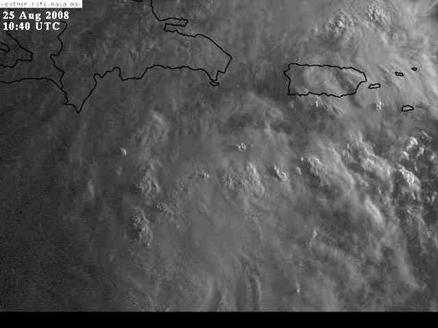
Wait till the NHC people have their coffee and get a look at the low level structure in the first visibles.
I'm guessing the initial LLC structure is settling down on a WNW track from about 14.5 N. Upper level flow is currently pushing to the W/WNW and the ULL to the north is drifting east where it could help ventilate the outflow.
ATL GUSTAV: Tropical Depression - Discussion
Moderator: S2k Moderators
Re: ATL: Invest 94L in Eastern Caribbean Sea
Last edited by Nimbus on Mon Aug 25, 2008 4:38 am, edited 1 time in total.
0 likes
-
Matt-hurricanewatcher
Re: ATL: Invest 94L in Eastern Caribbean Sea
I believe that it is now IS a depression. If you disagree then show me where I'm wrong, thank you.
0 likes

Re: ATL: Invest 94L in Eastern Caribbean Sea
I noticed that in the current TWO, the motion is WNW, and that it said that recon would fly into it "...if necessary." In the STDS, the motion is now WNW or NW and the words "if necessary" have been dropped. Am assuming this means there will definitely be recon.
On the regular forecast, NWS mentions a high over FL and the northwestern Caribbean. Enough to block this system? Or might a weakness be developing?
On the regular forecast, NWS mentions a high over FL and the northwestern Caribbean. Enough to block this system? Or might a weakness be developing?
0 likes
-
lamsalfl

- Tropical Depression

- Posts: 79
- Age: 43
- Joined: Thu Aug 16, 2007 1:46 am
- Location: New Orleans, LA
Re: ATL: Invest 94L in Eastern Caribbean Sea
definitely a depression now. It's just that 2008 is the year the NHC picked to skip depression status and wait for it to become tropical storms.
0 likes
-
Tampa_God

- Category 1

- Posts: 333
- Age: 36
- Joined: Wed May 31, 2006 7:27 pm
- Location: New Port Richey/Trinity, FL
Re: ATL: Invest 94L in Eastern Caribbean Sea
I expect this thing is already a TD. Last night I was even leaning on that NHC might even skip td status and name it and that might still happen, but I'll let the pro mets discuss that.
0 likes
-
Matt-hurricanewatcher
Re: ATL: Invest 94L in Eastern Caribbean Sea
Personal Forecast Disclaimer:
The posts in this forum are NOT official forecast and should not be used as such. They are just the opinion of the poster and may or may not be backed by sound meteorological data. They are NOT endorsed by any professional institution or storm2k.org. For official information, please refer to the NHC and NWS products.[/quote
I believe a well defined LLC has developed over the last few hours; also you can clearly see that this system is very well stacked low to mid levels. That shows that at all levels, we have favorable upper levels based on this. This also has great upper level environment with shear of around 5 knots shown by cimss, with 28-29c sst's. Overall, I would say that this is between a 30-35 knots right now. Meaning, I believe this could be a strong depression currently.
Two tracks
1# West-northwest=no landfall over Hati, Cuba and around 48 hours of water+. IF it does that I expect it to become a hurricane. Maybe 75 knots before Jamaica. Then a restrengthing to 80-85 knots over the western Caribbean just south of Cuba.
2# northwest track into northwest Hati, between Cuba and Hati or Cuba. This would give it about 24-36 more hours. But would also have it dealing with land to some part. So a weaker system. Around 55-60 knots...This is the northern models.
I believe it will go just north of 1# at the moment. But we will see. I see a tropical storm this afternoon when recon gets in, if current trends keep up.
0 likes
-
Dean4Storms
- S2K Supporter

- Posts: 6358
- Age: 63
- Joined: Sun Aug 31, 2003 1:01 pm
- Location: Miramar Bch. FL

Re: ATL: Invest 94L in Eastern Caribbean Sea
Tallahassee NWS discussion mentions 94L:
A MID LEVEL TROUGH IS FCST TO AMPLIFY OVER THE ERN CONUS NEXT WEEKEND, PUSHING A
COLD FRONT INTO THE DEEP SOUTH. THE 25/00Z GFS SHOWS THE FRONT
STALLING ALONG THE NWRN EDGE OF THE CWA AS A LOW PRESSURE WAVE OVER
SRN AL/GA. THIS SAME TROUGH STEERS THE NEXT TROPICAL SYSTEM,
INDICATED BY THE 24/12Z ECMWF, ACROSS CNTRL CUBA, THE FL STRAITS AND
SERN COAST OF FL SUN AND MON. THE GFS DOES NOT PICK ON THIS FEATURE.
REGARDLESS, THIS SYSTEM WILL HAVE TO BE CLOSELY MONITORED THIS WEEK.
0 likes
-
Gustywind

- Category 5

- Posts: 12334
- Joined: Mon Sep 03, 2007 7:29 am
- Location: Baie-Mahault, GUADELOUPE
000
AXNT20 KNHC 251033
TWDAT
TROPICAL WEATHER DISCUSSION
NWS TPC/NATIONAL HURRICANE CENTER MIAMI FL
805 AM EDT MON AUG 25 2008
TROPICAL WEATHER DISCUSSION FOR NORTH AMERICA...CENTRAL
AMERICA...GULF OF MEXICO...CARIBBEAN SEA...NORTHERN SECTIONS
OF SOUTH AMERICA...AND ATLANTIC OCEAN TO THE AFRICAN COAST
FROM THE EQUATOR TO 32N. THE FOLLOWING INFORMATION IS BASED
ON SATELLITE IMAGERY...METEOROLOGICAL ANALYSIS...WEATHER
OBSERVATIONS...AND RADAR.
BASED ON 0600 UTC SURFACE ANALYSIS AND SATELLITE IMAGERY THROUGH
1015 UTC.
...SPECIAL FEATURES...
BROAD AREA OF LOW PRESSURE IN THE SE CARIBBEAN WITH A 1006 MB
LOW ANALYZED NEAR 14N68W MOVING WNW NEAR 15 KT. SATELLITE
IMAGERY...SURFACE OBSERVATIONS...AND RADAR DATA FROM THE
NETHERLAND ANTILLES INDICATE THE LOW PRESSURE AREA OVER THE
CENTRAL CARIBBEAN SEA IS BECOMING BETTER ORGANIZED. THIS SYSTEM
COULD BECOME A TROPICAL DEPRESSION AT ANY TIME. AN AIR FORCE
RESERVE HURRICANE HUNTER AIRCRAFT IS SCHEDULED TO INVESTIGATE
THIS SYSTEM THIS AFTERNOON. SCATTERED/NUMEROUS STRONG CONVECTION
IS WITHIN 120 NM FROM THE CENTER IN THE NW SEMICIRCLE. CLUSTERS
OF SCATTERED MODERATE/ISOLATED STRONG CONVECTION ARE OVER THE E
CARIBBEAN S OF 20N FROM 60W-73W INCLUDING THE LESSER ANTILLES
THROUGH THE DOMINICAN REPUBLIC.
0 likes
-
alan1961

- Category 2

- Posts: 771
- Joined: Mon Mar 20, 2006 11:58 am
- Location: Derby, Derbyshire, England
- Contact:
Re: ATL: Invest 94L in Eastern Caribbean Sea
Give this site a try for anyone that has not discovered it..you can sign up for a trial even if it only means watching possible Gustav for a week or more 
http://www.weathertap.com/protected/sta ... ional.html
http://www.weathertap.com/protected/sta ... ional.html
0 likes
-
O Town
- S2K Supporter
- Posts: 5205
- Age: 52
- Joined: Wed Sep 07, 2005 9:37 pm
- Location: Orlando, Florida 28°35'35"N 81°22'55"W
Rut roh.
Looks like this system got its act together over night.
Recon is supposed to fly in at 2pm.
000
NOUS42 KNHC 241515
WEATHER RECONNAISSANCE FLIGHTS
CARCAH, NATIONAL HURRICANE CENTER, MIAMI, FL.
1100 AM EDT SUN 24 AUGUST 2008
SUBJECT: TROPICAL CYCLONE PLAN OF THE DAY (TCPOD)
VALID 25/1100Z TO 26/1100Z AUGUST 2008
TCPOD NUMBER.....08-085
I. ATLANTIC REQUIREMENTS
1. CARIBBEAN SUSPECT AREA
FLIGHT ONE - TEAL 70
A. 25/1800Z
B. AFXXX 01EEA INVEST
C. 25/1430Z
D. 15.5N 70.0W
E. 25/1700Z TO 25/2200Z
F. SFC TO 10,000 FT
FLIGHT TWO ? TEAL 71
A. 26/0600Z
B. AFXXX 0207A CYCLONE
C. 26/0300Z
D. 16.5N 72.0W
E. 26/0500Z TO 26/1200Z
F. SFC TO 10,000 FT
2. SUCCEEDING DAY OUTLOOK: CONTINUE 6-HRLY FIXES
IF SYSTEM DEVELOPS.
0 likes
-
cycloneye

- Admin

- Posts: 149310
- Age: 69
- Joined: Thu Oct 10, 2002 10:54 am
- Location: San Juan, Puerto Rico
Re: ATL: Invest 94L in Eastern Caribbean Sea
We are getting the tail in the form of bands moving north and northwest.
AREA FORECAST DISCUSSION
NATIONAL WEATHER SERVICE SAN JUAN PR
559 AM AST MON AUG 25 2008
.DISCUSSION...THE BROAD AREA OF LOW PRESSURE ACROSS THE EASTERN
CARIBBEAN JUST SOUTH SOUTHWEST OF PUERTO RICO OR NEAR 14.4 NORTH
68.2 WEST EARLY THIS MORNING...WILL CONTINUE TO MOVE WEST
NORTHWESTWARD AT 10 TO 15 MPH ACROSS THE CARIBBEAN WATERS TODAY.
UPPER-LEVEL WINDS ARE CURRENTLY FAVORABLE FOR DEVELOPMENT...AND THE
SYSTEM COULD BECOME A TROPICAL DEPRESSION LATER TODAY.
AN AREA OF MOISTURE IN THE NORTHERN FRINGE OF THIS SYSTEM MOVED
ACROSS THE LOCAL CARIBBEAN COASTAL WATERS AND THE LOCAL ISLANDS
OVERNIGHT PRODUCING THUNDERSTORMS WITH ECHO TOPS UP TO 60K FEET OVER
THE CARIBBEAN WATERS. A MARINE WEATHER STATEMENT WAS ISSUED FOR
THESE COASTAL WATERS EARLY IN THE MORNING. THE INTERACTION OF THIS
MOISTURE WITH THE LAND BREEZE...REDUCED THE INTENSITY OF THE
STORMS AND ONLY LIGHT TO MODERATE RAIN SHOWERS WERE OBSERVED OVER
LAND AREAS ACROSS PUERTO RICO OVERNIGHT. LIGHT TO MODERATE AND
OCASSIONAL HEAVY SHOWERS AND THUNDERSTORMS WERE OBSERVED ACROSS
VIEQUES...CULEBRA AND THE U.S. VIRGIN ISLANDS OVERNIGHT.
HOWEVER...JUST BEFORE SUNRISE...ANOTHER AREA OF STRONG
THUNDERSTORMS DEVELOPED ACROSS THE SOUTHEASTERN CARIBBEAN COASTAL
WATERS. THIS ACTIVITY WILL CONTINUE TO MOVE INLAND OVER THE SOUTH
AND SOUTHEASTERN SECTIONS OF PUERTO RICO AS WELL ACROSS VIEQUES
AND CULEBRA...PRODUCING SHOWERS...LIGHTNING AND THUNDERSTORMS
ACROSS THESE SECTORS. FOR THIS AFTERNOON THE COMBINATION OF THIS
MOISTURE...LOCAL TERRAIN EFFECTS AND A MOIST SOUTH SOUTHEASTERLY
WIND FLOW WILL PROMOTE THE DEVELOPMENT OF SHOWERS AND
THUNDERSTORMS ACROSS THE LOCAL ISLANDS. AS THE LOW PRESSURE SYSTEM
MOVES TO THE WEST NORTHWEST...MOISTURE WILL CONTINUE TO STREAM IN
OVER THE AREA AND INTERMITTENT PERIODS OF RAIN AND SHOWERS WILL
OCCUR OVER MANY AREAS OF THE ISLAND INCLUDING CULEBRA AND VIEQUES
FOR THE REST OF THE WORK WEEK. THE GFS MODEL GUIDANCE SUGGESTS A
MOIST AND UNSTABLE WEATHER PATTERN ACROSS THE FA FOR THE WHOLE
WORK WEEK...WITH SEVERAL AREAS OF SURFACE LOWS DEVELOPING AROUND
THE REGION DURING THE NEXT SEVERAL DAYS. AN UPPER LEVEL TROUGH
(TUTT) NORTH NORTHWEST OF THE LOCAL ISLANDS THIS MORNING...WILL
ALSO PERSIST NEAR THE REGION DURING THE NEXT SEVERAL DAYS
ENHANCING THE SHOWERS AND THUNDERSTORMS ACTIVITY ACROSS THE FA.
http://www.srh.noaa.gov/fwd/productview ... &version=0
0 likes
-
HurricaneHunter914
- Category 5
- Posts: 4439
- Age: 32
- Joined: Fri Mar 10, 2006 7:36 pm
- Location: College Station, TX
Aren't there any surface obs they can use out there? bouys, ships, etc? Because, 94L is probably a TD right now.
http://www.ssd.noaa.gov/goes/flt/t2/avn-l.jpg
It's not the best tool to use, but you can even see the circulation on this!
http://www.ssd.noaa.gov/goes/flt/t2/avn-l.jpg
It's not the best tool to use, but you can even see the circulation on this!
0 likes
-
HURAKAN

- Professional-Met

- Posts: 46084
- Age: 39
- Joined: Thu May 20, 2004 4:34 pm
- Location: Key West, FL
- Contact:
Re: ATL: Invest 94L in Central Caribbean Sea
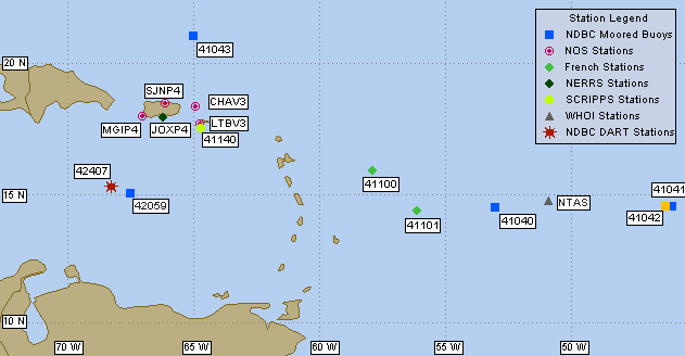
Conditions at 42059 as of
1050 GMT on 08/25/2008:
Code: Select all
Wind Direction (WDIR):   SSE ( 150 deg true )
Wind Speed   Wind Speed (WSPD):   17.5 kts
Wind Gust   Wind Gust (GST):   25.3 kts
Wave Height   Wave Height (WVHT):   6.6 ft
Dominant Wave Period   Dominant Wave Period (DPD):   6 sec
Average Period   Average Period (APD):   4.6 sec
Atmospheric Pressure   Atmospheric Pressure (PRES):   29.80 in
Pressure Tendency   Pressure Tendency (PTDY):   +0.04 in ( Rising )
If there is a LLC, it's not very impressive. 94L seems to be another one of those that say "I look so good that I fool you!"
0 likes
-
Ed Mahmoud
Re: ATL: Invest 94L in Central Caribbean Sea
Sure looks good on satellite. Visible loop should have a few frames soon, anyway.
Unofficially, I like the Canadian track, towards Florida. Not that I'm wishing another storm on Florida so soon after the last one, just, unofficially and in my amateur opinion, seems like a possible track.
I hope they wouldn't cancel a football game in Texas because a hurricane is headed to the visiting school's (Florida Atlantic) area. I got tickets and hotel reservations in Austin. But I couldn't blame FAU if they did.
0 likes
-
TreasureIslandFLGal

- S2K Supporter
- Posts: 1584
- Age: 58
- Joined: Sun Aug 15, 2004 6:16 pm
- Location: Cancun, Mexico (northeast Yucatan coast)
Re: ATL: Invest 94L in Eastern Caribbean Sea
N2FSU wrote:Tallahassee NWS discussion mentions 94L:
A MID LEVEL TROUGH IS FCST TO AMPLIFY OVER THE ERN CONUS NEXT WEEKEND, PUSHING A
COLD FRONT INTO THE DEEP SOUTH. THE 25/00Z GFS SHOWS THE FRONT
STALLING ALONG THE NWRN EDGE OF THE CWA AS A LOW PRESSURE WAVE OVER
SRN AL/GA. THIS SAME TROUGH STEERS THE NEXT TROPICAL SYSTEM,
INDICATED BY THE 24/12Z ECMWF, ACROSS CNTRL CUBA, THE FL STRAITS AND
SERN COAST OF FL SUN AND MON. THE GFS DOES NOT PICK ON THIS FEATURE.
REGARDLESS, THIS SYSTEM WILL HAVE TO BE CLOSELY MONITORED THIS WEEK.
Wow this seems like a pretty detailed discussion for them. They essentially lay out the path of the storm. I wonder if the big boys have laid out this same path? They rarely disagree between them. So it looks like a cut across cuba and then to the NE to affect SE Florida?
That's an awfully long way out for one of these to actually indicate a landfall area! -I liek that they are taking a stab at it this early, but this is a case where they are too far out to do so. People may let their guard down in other areas, and it is WAY too early to do so.
0 likes
Who is online
Users browsing this forum: No registered users and 5 guests