ATL GUSTAV: Tropical Depression - Discussion

Moderator: S2k Moderators

Message
Author
User avatar
Portastorm
Storm2k Moderator
Storm2k Moderator
Posts: 9914
Age: 63
Joined: Fri Jul 11, 2003 9:16 am
Location: Round Rock, TX
Contact:

Re: ATL: Invest 94L in Central Caribbean Sea

#1081 Postby Portastorm » Mon Aug 25, 2008 6:40 am

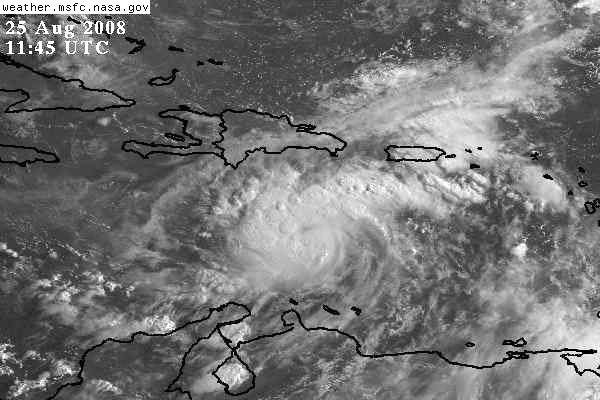
Ed Mahmoud wrote:Sure looks good on satellite. Visible loop should have a few frames soon, anyway.

Unofficially, I like the Canadian track, towards Florida. Not that I'm wishing another storm on Florida so soon after the last one, just, unofficially and in my amateur opinion, seems like a possible track.

I hope they wouldn't cancel a football game in Texas because a hurricane is headed to the visiting school's (Florida Atlantic) area. I got tickets and hotel reservations in Austin. But I couldn't blame FAU if they did.


The system is going to have to start a pretty dramatic northward component to make the Canadian worth believing. Nah Ed, I'm thinking Gustav-to-be wants to come see you in Texas! :wink:
0 likes   

Aric Dunn
Category 5
Category 5
Posts: 21238
Age: 42
Joined: Sun Sep 19, 2004 9:58 pm
Location: Ready for the Chase.
Contact:

Re:

#1082 Postby Aric Dunn » Mon Aug 25, 2008 6:44 am

Derek Ortt wrote:http://cimss.ssec.wisc.edu/tropic/real-time/atlantic/winds/wg8conv.html

convergence is MUCH better this morning


yes quite a bit better.. also has a much more pronounced upper ridge over it
0 likes   

JabNOLA
Tropical Low
Tropical Low
Posts: 35
Joined: Mon Aug 09, 2004 11:00 am
Location: New Orleans, Louisiana

Re: ATL: Invest 94L in Central Caribbean Sea

#1083 Postby JabNOLA » Mon Aug 25, 2008 6:49 am

Looking really good for this stage of development.
Last edited by JabNOLA on Mon Aug 25, 2008 6:54 am, edited 1 time in total.
0 likes   

User avatar
cycloneye
Admin
Admin
Posts: 145384
Age: 68
Joined: Thu Oct 10, 2002 10:54 am
Location: San Juan, Puerto Rico

Re: ATL: Invest 94L in Central Caribbean Sea

#1084 Postby cycloneye » Mon Aug 25, 2008 6:50 am

ABNT20 KNHC 251149
TWOAT
TROPICAL WEATHER OUTLOOK
NWS TPC/NATIONAL HURRICANE CENTER MIAMI FL
800 AM EDT MON AUG 25 2008

FOR THE NORTH ATLANTIC...CARIBBEAN SEA AND THE GULF OF MEXICO...

THE HYDROMETEOROLOGICAL PREDICTION CENTER IS ISSUING PUBLIC
ADVISORIES ON TROPICAL DEPRESSION FAY LOCATED OVER SOUTHERN
MISSISSIPPI.

:rarrow: SATELLITE AND SURFACE OBSERVATIONS INDICATE THAT THE LOW PRESSURE
AREA LOCATED OVER THE CENTRAL CARIBBEAN ABOUT 250 MILES SOUTH OF
SANTO DOMINGO CONTINUES TO SHOW SIGNS OF ORGANIZATION. UPPER-LEVEL
WINDS ARE FAVORABLE FOR ADDITIONAL DEVELOPMENT...AND THE SYSTEM
COULD BECOME A TROPICAL DEPRESSION AT ANY TIME TODAY OR TONIGHT.
WATCHES AND/OR WARNINGS MAY BE REQUIRED FOR PORTIONS OF HISPANIOLA
LATER TODAY. INTERESTS IN JAMAICA...EASTERN CUBA...AND THE
SOUTHEASTERN BAHAMAS SHOULD MONITOR THE PROGRESS OF THE LOW AS IT
MOVES NORTHWESTWARD AT 10 TO 15 MPH. AN AIR FORCE RESERVE UNIT
RECONNAISSANCE AIRCRAFT IS SCHEDULED TO INVESTIGATE THE SYSTEM
LATER TODAY.

DISORGANIZED CLOUDINESS AND SHOWERS LOCATED SEVERAL HUNDRED MILES
NORTHEAST OF THE LEEWARD ISLANDS ARE ASSOCIATED WITH A TROPICAL
WAVE. UPPER-LEVEL WINDS ARE NOT CURRENTLY FAVORABLE FOR TROPICAL
CYCLONE FORMATION AND DEVELOPMENT...IF ANY...IS EXPECTED TO BE SLOW
TO OCCUR.

ELSEWHERE...TROPICAL CYCLONE FORMATION IS NOT EXPECTED DURING THE
NEXT 48 HOURS.

$$
FORECASTER BROWN/PASCH
0 likes   

User avatar
perk
Category 3
Category 3
Posts: 825
Joined: Mon Aug 09, 2004 9:35 am
Location: Richmond Texas

Re:

#1085 Postby perk » Mon Aug 25, 2008 6:51 am

Derek Ortt wrote:http://cimss.ssec.wisc.edu/tropic/real-time/atlantic/winds/wg8conv.html

convergence is MUCH better this morning

Derek do you anticipate a straight foward track with 94L, or a complicated set up.
0 likes   

rockyman
Category 5
Category 5
Posts: 1967
Joined: Thu Jun 26, 2003 12:24 pm
Location: Dauphin Island, AL

#1086 Postby rockyman » Mon Aug 25, 2008 7:00 am

NHC says system is now moving NW...earlier they had it moving "WNW or NW"
0 likes   

User avatar
Portastorm
Storm2k Moderator
Storm2k Moderator
Posts: 9914
Age: 63
Joined: Fri Jul 11, 2003 9:16 am
Location: Round Rock, TX
Contact:

Re:

#1087 Postby Portastorm » Mon Aug 25, 2008 7:02 am

rockyman wrote:NHC says system is now moving NW...earlier they had it moving "WNW or NW"


Indeed they do, not to mention NHC says movement at 10-15 mph which is a bit slower than what the system has been pegged at. I would love to have Wxman57's analysis but looks like a current movement at 290-300.
0 likes   

Matt-hurricanewatcher

Re: 94L=8 AM TWO=TD at anytime/Watches or Warnings later today

#1088 Postby Matt-hurricanewatcher » Mon Aug 25, 2008 7:05 am

Looks like another land lover to me. It is racing to move over the spin of Cuba...Weird season if you ask me.
0 likes   

HURRICANELONNY
Category 5
Category 5
Posts: 1383
Joined: Wed May 07, 2003 6:48 am
Location: HOLLYWOOD.FL

Re: 94L=8 AM TWO=TD at anytime/Watches or Warnings later today

#1089 Postby HURRICANELONNY » Mon Aug 25, 2008 7:05 am

I can't beleive people are believing the Canadian model. It always points to Florida. I don't think it will catch the trough that is progged for the end of the week. I say Gulf somewhere :eek:
0 likes   

tgenius
S2K Supporter
S2K Supporter
Posts: 1160
Joined: Mon May 15, 2006 5:31 pm
Location: Miami, FL

Re: 94L=8 AM TWO=TD at anytime/Watches or Warnings later today

#1090 Postby tgenius » Mon Aug 25, 2008 7:07 am

I have serious doubts in this thing coming towards Florida, specifically SE FL.. it would need to hang a pretty significant Northern component pretty soon (Yes I know it has gone from WNW to NW) though the slowdown does help it a bit to be more possible.
0 likes   

Chigger_Lopez
Tropical Depression
Tropical Depression
Posts: 72
Joined: Thu Sep 11, 2003 10:11 pm
Location: Jupiter, FL

Re: ATL: Invest 94L in Eastern Caribbean Sea

#1091 Postby Chigger_Lopez » Mon Aug 25, 2008 7:09 am

N2FSU wrote:Tallahassee NWS discussion mentions 94L:

A MID LEVEL TROUGH IS FCST TO AMPLIFY OVER THE ERN CONUS NEXT WEEKEND, PUSHING A
COLD FRONT INTO THE DEEP SOUTH. THE 25/00Z GFS SHOWS THE FRONT
STALLING ALONG THE NWRN EDGE OF THE CWA AS A LOW PRESSURE WAVE OVER
SRN AL/GA. THIS SAME TROUGH STEERS THE NEXT TROPICAL SYSTEM,
INDICATED BY THE 24/12Z ECMWF, ACROSS CNTRL CUBA, THE FL STRAITS AND
SERN COAST OF FL SUN AND MON. THE GFS DOES NOT PICK ON THIS FEATURE.
REGARDLESS, THIS SYSTEM WILL HAVE TO BE CLOSELY MONITORED THIS WEEK.


94L wont be anywhere near S. Florida by the end of the weekend unless it slows to a crawl which is hard to see happening. Any weakness or trough will not be in play unless this slows the heck down, which I personally hope that it does not. Sorry Gulf people.
0 likes   

TideJoe
Tropical Storm
Tropical Storm
Posts: 155
Joined: Fri Aug 15, 2008 1:05 pm

Re: ATL: Invest 94L in Eastern Caribbean Sea

#1092 Postby TideJoe » Mon Aug 25, 2008 7:13 am

Chigger_Lopez wrote:
N2FSU wrote:Tallahassee NWS discussion mentions 94L:

A MID LEVEL TROUGH IS FCST TO AMPLIFY OVER THE ERN CONUS NEXT WEEKEND, PUSHING A
COLD FRONT INTO THE DEEP SOUTH. THE 25/00Z GFS SHOWS THE FRONT
STALLING ALONG THE NWRN EDGE OF THE CWA AS A LOW PRESSURE WAVE OVER
SRN AL/GA. THIS SAME TROUGH STEERS THE NEXT TROPICAL SYSTEM,
INDICATED BY THE 24/12Z ECMWF, ACROSS CNTRL CUBA, THE FL STRAITS AND
SERN COAST OF FL SUN AND MON. THE GFS DOES NOT PICK ON THIS FEATURE.
REGARDLESS, THIS SYSTEM WILL HAVE TO BE CLOSELY MONITORED THIS WEEK.


94L wont be anywhere near S. Florida by the end of the weekend unless it slows to a crawl which is hard to see happening. Any weakness or trough will not be in play unless this slows the heck down, which I personally hope that it does not. Sorry Gulf people.


Hey we're used to it. The last two years were a nice break and gave everyone a chance to rebuild. I suspected 2008 or 2009 would cause some nervousness.
0 likes   

Sirius LeWindy
Tropical Depression
Tropical Depression
Posts: 61
Age: 48
Joined: Tue Aug 12, 2008 9:29 am
Location: On the beach in NC

Re: 94L=8 AM TWO=TD at anytime/Watches or Warnings later today

#1093 Postby Sirius LeWindy » Mon Aug 25, 2008 7:14 am

Most posters around here did not think Fay would turn either. A Storm2k westward bias?
0 likes   

rockyman
Category 5
Category 5
Posts: 1967
Joined: Thu Jun 26, 2003 12:24 pm
Location: Dauphin Island, AL

Re: 94L=8 AM TWO=TD at anytime/Watches or Warnings later today

#1094 Postby rockyman » Mon Aug 25, 2008 7:16 am

Sirius LeWindy wrote:Most posters around here did not think Fay would turn either. A Storm2k westward bias?


And there were plenty of others who thought Fay was going to the Carolinas.
0 likes   

User avatar
HURAKAN
Professional-Met
Professional-Met
Posts: 46086
Age: 38
Joined: Thu May 20, 2004 4:34 pm
Location: Key West, FL
Contact:

#1095 Postby HURAKAN » Mon Aug 25, 2008 7:21 am

Image

Gustav, if that's you, knock three times!
0 likes   

User avatar
gatorcane
S2K Supporter
S2K Supporter
Posts: 23691
Age: 47
Joined: Sun Mar 13, 2005 3:54 pm
Location: Boca Raton, FL

Re: 94L=8 AM TWO=TD at anytime/Watches or Warnings later today

#1096 Postby gatorcane » Mon Aug 25, 2008 7:22 am

Good morning all NHC has upgraded to code red as I predicted when I said "this system was a go" on Friday.....

Looks more impressive this morning and that NW turn is starting to commence. Florida may have to watch 94L. I'm going to look at the synoptics this morning and see what the threat zone looks like at this point.
0 likes   

User avatar
ExBailbonds
Tropical Storm
Tropical Storm
Posts: 142
Joined: Wed Sep 06, 2006 12:03 am
Location: Homestead,Fl
Contact:

Re:

#1097 Postby ExBailbonds » Mon Aug 25, 2008 7:25 am

HURAKAN wrote:
Gustav, if that's you, knock three times!


Knock Knock Knock ya it's me Gustav just waiting for the official call from the NHC.
0 likes   

jlauderdal
S2K Supporter
S2K Supporter
Posts: 7183
Joined: Wed May 19, 2004 5:46 am
Location: NE Fort Lauderdale
Contact:

Re: ATL: Invest 94L in Eastern Caribbean Sea

#1098 Postby jlauderdal » Mon Aug 25, 2008 7:25 am

Chigger_Lopez wrote:
N2FSU wrote:Tallahassee NWS discussion mentions 94L:

A MID LEVEL TROUGH IS FCST TO AMPLIFY OVER THE ERN CONUS NEXT WEEKEND, PUSHING A
COLD FRONT INTO THE DEEP SOUTH. THE 25/00Z GFS SHOWS THE FRONT
STALLING ALONG THE NWRN EDGE OF THE CWA AS A LOW PRESSURE WAVE OVER
SRN AL/GA. THIS SAME TROUGH STEERS THE NEXT TROPICAL SYSTEM,
INDICATED BY THE 24/12Z ECMWF, ACROSS CNTRL CUBA, THE FL STRAITS AND
SERN COAST OF FL SUN AND MON. THE GFS DOES NOT PICK ON THIS FEATURE.
REGARDLESS, THIS SYSTEM WILL HAVE TO BE CLOSELY MONITORED THIS WEEK.


94L wont be anywhere near S. Florida by the end of the weekend unless it slows to a crawl which is hard to see happening. Any weakness or trough will not be in play unless this slows the heck down, which I personally hope that it does not. Sorry Gulf people.


the nhc says all interests in se bahamas should watch out so they would disagree with you
0 likes   

User avatar
deltadog03
Professional-Met
Professional-Met
Posts: 3580
Joined: Tue Jul 05, 2005 6:16 pm
Location: Macon, GA

Re: 94L=8 AM TWO=TD at anytime/Watches or Warnings later today

#1099 Postby deltadog03 » Mon Aug 25, 2008 7:25 am

Ok, for entertainment puposes, I saved this image from the last wed. nights 00z euro run...**(basically 00z thurs. run) Would be crazy to see if a model could hit that, being that far out.

Image
Image
0 likes   

User avatar
gatorcane
S2K Supporter
S2K Supporter
Posts: 23691
Age: 47
Joined: Sun Mar 13, 2005 3:54 pm
Location: Boca Raton, FL

#1100 Postby gatorcane » Mon Aug 25, 2008 7:26 am

:uarrow:

Indeed the weakness in the subtropical ridge is HUGE about when you get to the longitude of the Bahamas and FL into the E GOM. So a Northerly turn is bound to happen somewhere south of Cuba so I do agree with the NHC about the SE Bahamas needing to watch 94L.

If you click this WV loop you can see what I mean:
http://www.ssd.noaa.gov/goes/east/tatl/loop-wv.html

Fay has created a giant hole in the area I mentioned above...and Fay is getting bumped ENE now (but gradually) and is getting caught up in the Westerlies, leaving that hole or weakness around for several days longer I'm afraid.
Last edited by gatorcane on Mon Aug 25, 2008 7:31 am, edited 6 times in total.
0 likes   


Return to “2008”

Who is online

Users browsing this forum: No registered users and 5 guests