ATL GUSTAV: Tropical Depression - Discussion
Moderator: S2k Moderators
-
deltadog03

- Professional-Met

- Posts: 3580
- Joined: Tue Jul 05, 2005 6:16 pm
- Location: Macon, GA

Re: 94L=8 AM TWO=TD at anytime/Watches or Warnings later today
Here we go again boys and girls. A Fay track redux? How many times in the past have we seen storms follow similar tracks as the previous one. I'm not saying that is going to happen with soon to be Gustav but the tracks from the models are looking awfully close to Fay - especially 5-6 days out. As of today, and we know this will change, the weakness in the mid-level ridge will be the eastern GOM - have to see maybe again if that hurricane deflector shield will work for Tampa.


0 likes
-
Blown Away

- S2K Supporter

- Posts: 10253
- Joined: Wed May 26, 2004 6:17 am
Re: 94L=8 AM TWO=TD at anytime/Watches or Warnings later today
Would SFL be in the 5 day cone if 94L becomes a TD?
0 likes
-
weatherguru18
Re: 94L=8 AM TWO=TD at anytime/Watches or Warnings later today
ronjon wrote:Here we go again boys and girls. A Fay track redux? How many times in the past have we seen storms follow similar tracks as the previous one. I'm not saying that is going to happen with soon to be Gustav but the tracks from the models are looking awfully close to Fay - especially 5-6 days out. As of today, and we know this will change, the weakness in the mid-level ridge will be the eastern GOM - have to see maybe again if that hurricane deflector shield will work for Tampa.
Hey, Houston has one of those shields as well. Something about a concave coast...hurricanes just don't like em'. I've been in Houston almost 20 years and I have NEVER seen a hurricane strike directly...well, Jerry but that doesn't really count.
0 likes


-
hurricanefloyd5

- Category 5

- Posts: 1659
- Age: 45
- Joined: Sun May 02, 2004 10:53 am
- Location: Spartanburg
- Contact:
Re: 94L=8 AM TWO=TD at anytime/Watches or Warnings later today
If this is going to be another florida storm then all floridanains to take cover in your boats and/or on your matteresses
0 likes
-
gatorcane

- S2K Supporter
- Posts: 23708
- Age: 48
- Joined: Sun Mar 13, 2005 3:54 pm
- Location: Boca Raton, FL
Re: 94L=8 AM TWO=TD at anytime/Watches or Warnings later today
Blown_away wrote:Would SFL be in the 5 day cone if 94L becomes a TD?
I think its definitely possible.
0 likes
-
deltadog03
- Professional-Met
- Posts: 3580
- Joined: Tue Jul 05, 2005 6:16 pm
- Location: Macon, GA
http://www.atmos.washington.edu/~ovens/ ... nhanced+12
That is a great WV link...Shows things from a larger scale....Its a big map so it takes a sec. or 2 to finish loading...
That is a great WV link...Shows things from a larger scale....Its a big map so it takes a sec. or 2 to finish loading...
0 likes
-
Pearl River

- S2K Supporter
- Posts: 825
- Age: 66
- Joined: Fri Dec 09, 2005 6:07 pm
- Location: SELa
Re: ATL: Invest 94L in Central Caribbean Sea
From Key West Disco:
LONG TERM (WEDNESDAY NIGHT THROUGH SUNDAY)...
THE DEEP...EAST-WEST ORIENTED RIDGE OVER THE FLORIDA PENINSULA AND
ADJACENT ATLANTIC AND GULF WATERS WILL BE STRETCHED OUT AND WEAKEN.
THIS WILL BE IN RESPONSE TO A DOUBLE ASSAULT BY A MID LATITUDE
DIGGING INTO THE SOUTHEAST UNITED STATES. THE SECOND ATTACK WILL
COME FROM AN ELONGATED CYCLONIC SYSTEM MIGRATING WESTWARD INTO THE
BAHAMAS AND WESTERN CARIBBEAN FRIDAY AND NEXT WEEKEND. WITH A
DISTINCT AND DEEP WEAKNESS IN THE SUBTROPICAL RIDGE OVER THE WEST
CENTRAL ATLANTIC...AND THE AFOREMENTIONED AREA OF HIGH
PRESSURE...ANY TROPICAL SYSTEM OVER THE WESTERN HALF OF THE
CARIBBEAN SEA WILL REMAIN WELL SOUTH OF OUR REGION. ALSO...ANY
POTENTIAL TROPICAL DISTURBANCE APPROACHING HISPANIOLA WILL BE DRAWN
NORTHWARD FAR REMOVED FROM OUR REGION. WITH THAT SAID...FORECAST
SOUNDINGS REVEAL AMPLE LOW LEVEL MOISTURE COMBINED WITH A FAIRLY
LIGHT NORTHEAST TO EAST WIND PROFILE WHICH SHOULD FAVOR CLOUD LINE
FORMATION. HENCE...WILL MAINTAIN CLIMO LOW CHANCE POPS AND AVERAGE
TEMPERATURES THROUGH THE PERIOD.
0 likes
-
cycloneye

- Admin

- Posts: 149311
- Age: 69
- Joined: Thu Oct 10, 2002 10:54 am
- Location: San Juan, Puerto Rico
Re: ATL: Invest 94L in Central Caribbean Sea
The 12:00 UTC Best track:
AL, 94, 2008082512, , BEST, 0, 151N, 696W, 30, 1006, DB
AL, 94, 2008082512, , BEST, 0, 151N, 696W, 30, 1006, DB
0 likes
-
cycloneye
- Admin
- Posts: 149311
- Age: 69
- Joined: Thu Oct 10, 2002 10:54 am
- Location: San Juan, Puerto Rico
Re: ATL: Invest 94L in Central Caribbean Sea
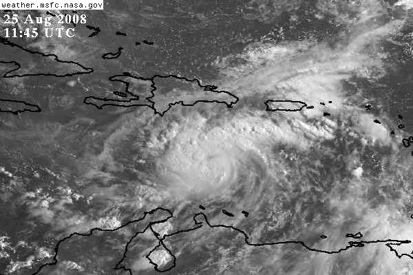
BEST TRACK and SSD DVORAK coincide on the position.
25/1145 UTC 15.1N 69.6W T2.5/2.5 94L -- Atlantic Ocean
25/1145 UTC 15.1N 69.6W T2.5/2.5 94L -- Atlantic Ocean
0 likes


-
Ed Mahmoud
Re: ATL: Invest 94L in Central Caribbean Sea
Portastorm wrote:Ed Mahmoud wrote:Sure looks good on satellite. Visible loop should have a few frames soon, anyway.
Unofficially, I like the Canadian track, towards Florida. Not that I'm wishing another storm on Florida so soon after the last one, just, unofficially and in my amateur opinion, seems like a possible track.
I hope they wouldn't cancel a football game in Texas because a hurricane is headed to the visiting school's (Florida Atlantic) area. I got tickets and hotel reservations in Austin. But I couldn't blame FAU if they did.
The system is going to have to start a pretty dramatic northward component to make the Canadian worth believing. Nah Ed, I'm thinking Gustav-to-be wants to come see you in Texas!
Joe Bastardi, AccuWx's Lead Hurricane Forecaster, on 7 am update, said Florida and Southeast, and implied Florida may once again owe a debt of gratitude to the 3 km peaks of Hispaniola. He also questions why NHC hasn't called this a depression already.
I'm ok waiting for recon...
0 likes
-
Pearl River
- S2K Supporter
- Posts: 825
- Age: 66
- Joined: Fri Dec 09, 2005 6:07 pm
- Location: SELa
Re: ATL: Invest 94L in Central Caribbean Sea
Question for any Pro Mets. What, if any effects, could Julio play on the steering currents from the Pacific/SW US side have on 94L?
Thanx,
Mike
Thanx,
Mike
0 likes

Re: ATL: Invest 94L in Central Caribbean Sea
sevenleft wrote:LLC? What LLC?
This will probably keep TPC from upgrading it before the plane gets there this afternoon. It might need some more time to get organized at the surface.
0 likes
-
cheezyWXguy

- Category 5
- Posts: 6282
- Joined: Mon Feb 13, 2006 12:29 am
- Location: Dallas, TX
Re: ATL: Invest 94L in Central Caribbean Sea
Thunder44 wrote:sevenleft wrote:LLC? What LLC?
This will probably keep TPC from upgrading it before the plane gets there this afternoon. It might need some more time to get organized at the surface.
Nope. We saw the same thing in Bertha when it was a major. Quikscat is a satellite, and sometimes cannot see all the way to the surface when rain is extremely heavy. Therefore, this and Bertha were portrayed as open waves, even though Bertha did and this one likely does have a llc.
0 likes


-
SouthFloridawx

- S2K Supporter
- Posts: 8346
- Age: 47
- Joined: Tue Jul 26, 2005 1:16 am
- Location: Sarasota, FL
- Contact:
Re: ATL: Invest 94L in Central Caribbean Sea
Look at the time stamp that is an old image.
cheezyWXguy wrote:Thunder44 wrote:sevenleft wrote:LLC? What LLC?
This will probably keep TPC from upgrading it before the plane gets there this afternoon. It might need some more time to get organized at the surface.
Nope. We saw the same thing in Bertha when it was a major. Quikscat is a satellite, and sometimes cannot see all the way to the surface when rain is extremely heavy. Therefore, this and Bertha were portrayed as open waves, even though Bertha did and this one likely does have a llc.
0 likes
Re: ATL: Invest 94L in Central Caribbean Sea
Ed Mahmoud wrote:Portastorm wrote:Ed Mahmoud wrote:Sure looks good on satellite. Visible loop should have a few frames soon, anyway.
Unofficially, I like the Canadian track, towards Florida. Not that I'm wishing another storm on Florida so soon after the last one, just, unofficially and in my amateur opinion, seems like a possible track.
I hope they wouldn't cancel a football game in Texas because a hurricane is headed to the visiting school's (Florida Atlantic) area. I got tickets and hotel reservations in Austin. But I couldn't blame FAU if they did.
The system is going to have to start a pretty dramatic northward component to make the Canadian worth believing. Nah Ed, I'm thinking Gustav-to-be wants to come see you in Texas!
Joe Bastardi, AccuWx's Lead Hurricane Forecaster, on 7 am update, said Florida and Southeast, and implied Florida may once again owe a debt of gratitude to the 3 km peaks of Hispaniola. He also questions why NHC hasn't called this a depression already.
I'm ok waiting for recon...
Did he specify where in Florida? just curious.
0 likes
-
caneman
Re: ATL: Invest 94L=SSD Dvorak T Numbers 2.5/2.5
Too add to that, I believe due to how fast it is moving can make it hard for quikscat to pick up a LLc. SOmeone feel free to correct me if I'm wrong but I believe that to be correct.
0 likes
Who is online
Users browsing this forum: No registered users and 7 guests