


Moderator: S2k Moderators


jinftl wrote:2pm CDT conditions...still worse in new orleans than houston proper
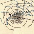
...shows that windfield is not uniform in extent in all quadrants of storm
N.O. INTL ARPT SE26G49
N.O. LAKEFRONT SE36G46
HOUSTON BUSH NE21
HOUSTON HOBBY NE21G32
PORT ARTHUR NE36G53
GALVESTON NOT AVBL


jinftl wrote:On current heading, it almost looks like a more nw motion would be needed...or at least some wobbles...to get the eye on shore to the right of galveston bay.


Sanibel wrote:From the looks of that eye I'd say High Island and Sabine Pass should get just about as bad of an impact as Galveston.
MiamiensisWx wrote:jinftl wrote:On current heading, it almost looks like a more nw motion would be needed...or at least some wobbles...to get the eye on shore to the right of galveston bay.
These trends are clearly disconcerting... it is increasingly probable that Ike will move ashore just SW of Galveston, which would imply that the highest surge heights would affect the city of Galveston and Galveston Bay, as well as points farther east.
Goodness...


Texas Snowman wrote:KHOU reporter indicating that Galveston may be under water for 12 hours when storm surge over runs the island.
jinftl wrote:Heading at 11am was 300 deg but from 11am to 2pm storm went from 27.2N 92.6W to 27.4N 93.1W....more west than north. wobbles are everything now....and i say that as a usual anti-wobble watcher.MiamiensisWx wrote:jinftl wrote:On current heading, it almost looks like a more nw motion would be needed...or at least some wobbles...to get the eye on shore to the right of galveston bay.
These trends are clearly disconcerting... it is increasingly probable that Ike will move ashore just SW of Galveston, which would imply that the highest surge heights would affect the city of Galveston and Galveston Bay, as well as points farther east.
Goodness...
lost cause wrote:I've been texting back and fort with a friend whose family is staying in the League City area (west of I-45) and they're back near their normal homestead in Dickinson near Dickinson Bayou. She said that the bayou is up 4 to 6 feet above normal and the air has a very strong salty taste in the air. I used to work in Dickinson for five years and I never once smelled the salty air like I do when I'm Galveston.
And the scary thing is the full power of this storm has yet to be realized.

Ptarmigan wrote:I think the Saffir-Simpsons scale needs some major changes. Hurricane Ike is a large Category 2 hurricane that will produce up to 25 foot high storm surge. I think there should be a scale based on how large the storm, not just the wind speed and central pressure.
Users browsing this forum: No registered users and 10 guests


