ATL: Tropical Depression Dolly
Moderator: S2k Moderators


-
Extremeweatherguy

- Category 5

- Posts: 11095
- Joined: Mon Oct 10, 2005 8:13 pm
- Location: Florida
Looks great right now for an invest. If this keeps up, then I suspect it will be named a tropical depression by tomorrow...
http://www.ssd.noaa.gov/goes/flt/t2/loop-vis.html
http://www.ssd.noaa.gov/goes/flt/t2/loop-vis.html
0 likes
-
gatorcane

- S2K Supporter

- Posts: 23708
- Age: 48
- Joined: Sun Mar 13, 2005 3:54 pm
- Location: Boca Raton, FL
Believe it or not, I was just looking at TVs in a retail store in Broward County -- as the sales person was flipping through the channels, one of the local channels was showing the area of disturbed weather that we may need to start watching here.
It's early for the media to be speculating in South Florida but given where it is trying to form and the general direction models take it, that may be why they are on to this one earlier than usual.
It's early for the media to be speculating in South Florida but given where it is trying to form and the general direction models take it, that may be why they are on to this one earlier than usual.
0 likes

-
bvigal

- S2K Supporter
- Posts: 2276
- Joined: Sun Jul 24, 2005 8:49 am
- Location: British Virgin Islands
- Contact:
Re:
RL3AO wrote:
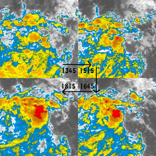
RL3AO - thanks for saving and posting those 4 pics. I just came in from church and lunch out, and it really helps to see what's transpired. I can clearly see the spin on visible sat, so no doubt trying to get organized. Don't see any adverse conditions to stop it, and the latitude doesn't bother me, many storms at this stage were below 10N. 18z model fix is 9.3N.
0 likes
-
Derek Ortt
floater added at http://www.nwhhc.com/satellite.html (a few hours are needed for a complete loop, since I just turned it on now... but loops are available in th C Atl sector)
0 likes


-
Tstormwatcher

- S2K Supporter
- Posts: 3086
- Joined: Thu Oct 20, 2005 7:31 pm
- Location: New Bern, NC
-
wxman57

- Moderator-Pro Met

- Posts: 23172
- Age: 68
- Joined: Sat Jun 21, 2003 8:06 pm
- Location: Houston, TX (southwest)
Re:
gatorcane wrote:Believe it or not, I was just looking at TVs in a retail store in Broward County -- as the sales person was flipping through the channels, one of the local channels was showing the area of disturbed weather that we may need to start watching here.
It's early for the media to be speculating in South Florida but given where it is trying to form and the general direction models take it, that may be why they are on to this one earlier than usual.
Both GFS and European are forecasting a stationary ridge over Florida and the NE Gulf in the 7-10 day time frame. That would seem to indicate that it would be hard for a storm to head toward Florida, and it points to the GFDL/HWRF solution of a NE Caribbean threat then a turn northward east of Florida. A tad early to be too confident in that 10 day location, though.
Looks like it's well on its way this afternoon to becoming a TD on Tuesday. I think tomorrow may be too soon.
0 likes


-
jaxfladude
- Category 5
- Posts: 1249
- Joined: Wed Aug 24, 2005 9:36 pm
- Location: Jacksonville, Fla
-
cycloneye

- Admin

- Posts: 149275
- Age: 69
- Joined: Thu Oct 10, 2002 10:54 am
- Location: San Juan, Puerto Rico
Re: ATL: INVEST 94L East of the Windward Islands
HURAKAN,that small yellow dot is where the low center is?
0 likes
Wouldn't that suggest a threat to the Carolinas then wxman57 because there doesn't seem to be enough on the models of a weakness to send this far enough to the east not to be of major threat to the east coast...
Still this is probably a good 7-10 days away yet so we have a while to see what happens.
I agree this is looking pretty good right now, probably less then 24hrs away now I reckon, nice deep convection with this invest today!!!
Ps....whats the odds this will be another top 10 thread on this board, probably very high if it tracks through the Ne caribbean...
0 likes
Who is online
Users browsing this forum: No registered users and 41 guests