
ATL: Tropical Depression Fay
Moderator: S2k Moderators
-
tolakram
- Admin

- Posts: 20168
- Age: 62
- Joined: Sun Aug 27, 2006 8:23 pm
- Location: Florence, KY (name is Mark)
Re: ATL: Invest 92L in Central Atlantic
Now see in my opinion I think we're looking at another complete collapse. Even the new convection south of the low pressure area is collapsing.
Last edited by tolakram on Wed Aug 13, 2008 3:51 pm, edited 1 time in total.
0 likes


-
Blown Away

- S2K Supporter

- Posts: 10253
- Joined: Wed May 26, 2004 6:17 am
Re: ATL: Invest 92L in Central Atlantic
Ed Mahmoud wrote:Vortex wrote:Folks,
We now can finally say we have a developing system. Organization the last few hours is l underway.
I've been burned before, but this is looking better by the frame.
I agree 92L looks good rate now, but we were all saying the same thing yesterday about this time and then the convection dissipated. 92l has to make it through the night and maintain the convection. I still see alot of clouds being blown off to the W of 92L, so the shear seems to still be there. If the convection is there tomorrow morning, then we have something, IMO.
0 likes
-
canetracker

- S2K Supporter
- Posts: 751
- Age: 63
- Joined: Wed Jul 27, 2005 8:49 pm
- Location: Suburbia New Orleans...Harahan, LA
Re: ATL: Invest 92L in Central Atlantic
Just found this Carbbean buoy site in my favorites but thought it may come in useful when tracking 92L:
http://www.srh.noaa.gov/sju/caribm.html
http://www.srh.noaa.gov/sju/caribm.html
0 likes

-
Blown Away
- S2K Supporter
- Posts: 10253
- Joined: Wed May 26, 2004 6:17 am
Re: ATL: Invest 92L in Central Atlantic
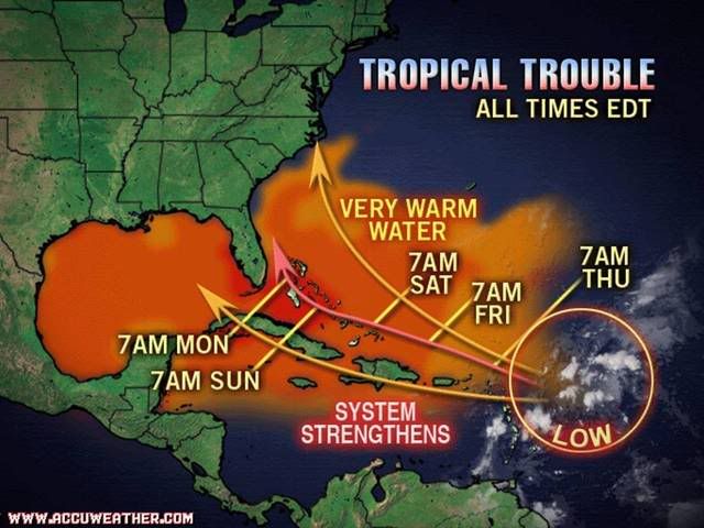
Got to love Accuweather, not wanting to commit to a SFL landfall, just twist the arrow point a little. 
0 likes
-
SWFLA_CANE

- Tropical Storm

- Posts: 196
- Joined: Tue Jun 06, 2006 6:41 pm
- Location: Naples, Florida
Re: ATL: Invest 92L in Central Atlantic
tolakram wrote:Now see in my opinion I think we're looking at another complete collapse. Even the new convection sound of the low pressure area is collapsing.
I have to agree. Cloud tops are warming and the weak circulation still appears to be displaced S.W. of the remaining convection
0 likes
-
Blown Away
- S2K Supporter
- Posts: 10253
- Joined: Wed May 26, 2004 6:17 am
Re: ATL: Invest 92L in Central Atlantic
Where is the approximate lat/long of the circulation rate now?
0 likes
-
Meso

- Category 5

- Posts: 1609
- Age: 39
- Joined: Mon Aug 09, 2004 12:14 pm
- Location: South Africa
- Contact:
Remember it's not expected to develop right away, all it has to do is maintain itself for the next few days and if it manages to get into the better atmospheric conditions while remaining alive, then things should really develop. This storm is completely bipolar though, one second it's void of convection and people call it dead, the next it's got a large blow up and looking healthy
0 likes
-
Extremeweatherguy

- Category 5
- Posts: 11095
- Joined: Mon Oct 10, 2005 8:13 pm
- Location: Florida
The Accuweather track looks pretty good, IMO. If I had to make a track for 92L right now, mine would be very similar, including the timeframes. Somewhere in the Northern Bahamas by Monday morning sounds about right to me.
The posts in this forum are NOT official forecast and should not be used as such. They are just the opinion of the poster and may or may not be backed by sound meteorological data. They are NOT endorsed by any professional institution or storm2k.org. For official information, please refer to the NHC and NWS products.
The posts in this forum are NOT official forecast and should not be used as such. They are just the opinion of the poster and may or may not be backed by sound meteorological data. They are NOT endorsed by any professional institution or storm2k.org. For official information, please refer to the NHC and NWS products.
0 likes

-
tolakram
- Admin
- Posts: 20168
- Age: 62
- Joined: Sun Aug 27, 2006 8:23 pm
- Location: Florence, KY (name is Mark)
Re: ATL: Invest 92L in Central Atlantic
The visible doesn't look bad, and the loop reveals some kind of, um, movement swirl thingy (highly technical term) in the vicinity of the convection ... but what that means I can not say.

Loop: http://rammb.cira.colostate.edu/ramsdis ... _floater_1
Loop: http://rammb.cira.colostate.edu/ramsdis ... _floater_1
0 likes

Re: ATL: Invest 92L in Central Atlantic
on the last visible at 20:15 notice the feathery texture to the clouds on the NW side..Often this occurs when a favorable upper-air environment exists...with this development a more symetrical system to come over the next few hours with the strong potential for deeper convection near the developing LLC overnight.
0 likes
-
gatorcane

- S2K Supporter
- Posts: 23703
- Age: 47
- Joined: Sun Mar 13, 2005 3:54 pm
- Location: Boca Raton, FL
Re:
Meso wrote:Remember it's not expected to develop right away, all it has to do is maintain itself for the next few days and if it manages to get into the better atmospheric conditions while remaining alive, then things should really develop. This storm is completely bipolar though, one second it's void of convection and people call it dead, the next it's got a large blow up and looking healthy
That's the key point here. Don't look for anything to organize very quickly quite yet, it may take another 48 hours before cyclonegenesis actually officially happens but since the environment appears very favorable in the long-term and models are generally pointing it at the SE US and Bahamas, it needs to be closely watched.
0 likes

-
gatorcane
- S2K Supporter
- Posts: 23703
- Age: 47
- Joined: Sun Mar 13, 2005 3:54 pm
- Location: Boca Raton, FL
Look at all the WSW winds across Southern FL --- shows the H5 ridge (Bermuda High) has not quite built in yet off the EC and troughiness is dominating the EC still.
It's a little hard to believe the pattern will just change to open up the door to anything tropical from the East but most of the models are in good agreement of it changing over the next few days.
W PALM BEACH PTSUNNY 92 70 48 W12G20 29.89F HX 97
FT LAUDER-EXEC MOSUNNY 93 67 42 SW14G22 29.90F HX 96
FT LAUDERDALE MOSUNNY 94 67 41 SW10G20 29.90F HX 97
POMPANO BEACH MOSUNNY 93 68 43 W13 29.90F HX 97
PEMBROKE PINES MOSUNNY 93 68 43 W13G21 29.93F HX 97
OPA LOCKA SUNNY 93 66 40 SW13G20 29.92F HX 96
MIAMI PTSUNNY 93 69 45 SW13 29.92F HX 98
WEST KENDALL MOSUNNY 91 70 49 W13 29.92F HX 96
HOMESTEAD MOSUNNY 91 76 61 SW12G17 29.93F HX 102
Last edited by gatorcane on Wed Aug 13, 2008 4:06 pm, edited 3 times in total.
0 likes
-
Blown Away
- S2K Supporter
- Posts: 10253
- Joined: Wed May 26, 2004 6:17 am
Re: ATL: Invest 92L in Central Atlantic
Nice summary again from Jeff Master's regarding the steering patterns.
http://www.wunderground.com/blog/JeffMa ... amp=200808
http://www.wunderground.com/blog/JeffMa ... amp=200808
0 likes
-
Aric Dunn
- Category 5
- Posts: 21238
- Age: 43
- Joined: Sun Sep 19, 2004 9:58 pm
- Location: Ready for the Chase.
- Contact:
Re: ATL: Invest 92L in Central Atlantic
center of the picture ... another burst starting ... right where we want convection to start firing

http://rammb.cira.colostate.edu/ramsdis ... _floater_1
http://rammb.cira.colostate.edu/ramsdis ... _floater_1
Last edited by Aric Dunn on Wed Aug 13, 2008 4:06 pm, edited 1 time in total.
0 likes
Who is online
Users browsing this forum: Google Adsense [Bot] and 23 guests