
ATL: Tropical Storm Kyle : Discussion
Moderator: S2k Moderators
-
Gustywind

- Category 5

- Posts: 12334
- Joined: Mon Sep 03, 2007 7:29 am
- Location: Baie-Mahault, GUADELOUPE
Hey...seems that it's the second correspondant speaking about the power the thunder ( pretty loud:eek: )  : this time more north from Montserrat!
And it came from the south
http://stormcarib.com/reports/current/montserrat.shtml
From: "Tina" <tbretton59 at msn.com>
Date: Sat, 20 Sep 2008 13:38:04 -0400
Whoa, very heavy rain storm came through here, unusual for it to come from the south.. Winds were not to bad but the rain was. Not much lightening but thunder was pretty loud, enough to send the dogs running for the nearest protector (human lap). It came through at about 11am, it is still rain but not as hard as earlier. The Belham Valley flooded and water is still running pretty good. From the looks of the blob, I guess we are in for some more heavy rain. It is a good thing we drove the car to the other side of the valley, we have to pick up some people from the airport later. Attached is the rains coming and of the water flooding the valley.
Whereas numerous floodings have been reported too, to see them go to http://stormcarib.com/reports/current/montserrat.shtml
0 likes
-
otowntiger
- Category 5
- Posts: 1932
- Joined: Tue Aug 31, 2004 7:06 pm
Re: ATL INVEST 93L: Discussion
wxman57 wrote:Still looks quite pathetic to me. Not much more than a typical tropical wave. Convection remains poorly-organized and displaced well east of the wave axis. Development chances low.
Isn't that pretty much how all cyclones start out?
0 likes

Re: ATL INVEST 93L: Discussion
cycloneye wrote:NHC puts the orange thing over my head literally.
Hope things don't go bad in PR Luis.
you guys always run the danger of flooding.
0 likes
Re: ATL INVEST 93L: Discussion
If what generally holds true....that a weaker,slow-to-organize system would have an easier time making it further west than if it developed quickly....this is one to watch for Puerto Rico, Hispanola, Cuba, Jamaica, the Turks & Caicos, and Bahamas.....and then the U.S.
0 likes


-
Blown Away

- S2K Supporter

- Posts: 10253
- Joined: Wed May 26, 2004 6:17 am
Re: ATL INVEST 93L: Discussion

Compared to yesterday, 93L looks much better. Convection finally near the LLC.
0 likes
-
Gustywind
- Category 5
- Posts: 12334
- Joined: Mon Sep 03, 2007 7:29 am
- Location: Baie-Mahault, GUADELOUPE
AXNT20 KNHC 201755
TWDAT
TROPICAL WEATHER DISCUSSION
NWS TPC/NATIONAL HURRICANE CENTER MIAMI FL
205 PM EDT SAT SEP 20 2008
TROPICAL WEATHER DISCUSSION FOR NORTH AMERICA...CENTRAL
AMERICA...GULF OF MEXICO...CARIBBEAN SEA...NORTHERN SECTIONS
OF SOUTH AMERICA...AND ATLANTIC OCEAN TO THE AFRICAN COAST
FROM THE EQUATOR TO 32N. THE FOLLOWING INFORMATION IS BASED
ON SATELLITE IMAGERY...METEOROLOGICAL ANALYSIS...WEATHER
OBSERVATIONS...AND RADAR.
BASED ON 1200 UTC SURFACE ANALYSIS AND SATELLITE IMAGERY THROUGH
1715 UTC.
...SPECIAL FEATURES...
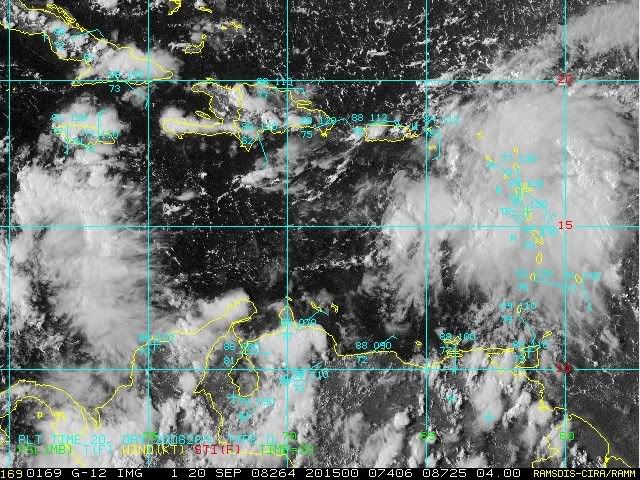
TROPICAL WAVE IS ALONG 66W S OF 19N MOVING W NEAR 10 KT. THIS
WAVE IS EMBEDDED WITHIN A BROAD AREA OF LOWER PRESSURE ACROSS
THE E CARIBBEAN AND IS GENERATING A LARGE AREA OF CLOUDINESS
WITH SCATTERED SHOWERS/ISOLATED THUNDERSTORMS FROM THE WAVE AXIS
ACROSS THE LESSER ANTILLES. THIS SYSTEM IS SHOWING SIGNS OF
IMPROVED ORGANIZATION TODAY AND UPPER-LEVEL WINDS ARE EXPECTED
TO BECOME SOMEWHAT MORE FAVORABLE OVER THE NEXT COUPLE DAYS FOR
SOME ADDITIONAL DEVELOPMENT TO OCCUR.
TWDAT
TROPICAL WEATHER DISCUSSION
NWS TPC/NATIONAL HURRICANE CENTER MIAMI FL
205 PM EDT SAT SEP 20 2008
TROPICAL WEATHER DISCUSSION FOR NORTH AMERICA...CENTRAL
AMERICA...GULF OF MEXICO...CARIBBEAN SEA...NORTHERN SECTIONS
OF SOUTH AMERICA...AND ATLANTIC OCEAN TO THE AFRICAN COAST
FROM THE EQUATOR TO 32N. THE FOLLOWING INFORMATION IS BASED
ON SATELLITE IMAGERY...METEOROLOGICAL ANALYSIS...WEATHER
OBSERVATIONS...AND RADAR.
BASED ON 1200 UTC SURFACE ANALYSIS AND SATELLITE IMAGERY THROUGH
1715 UTC.
...SPECIAL FEATURES...
TROPICAL WAVE IS ALONG 66W S OF 19N MOVING W NEAR 10 KT. THIS
WAVE IS EMBEDDED WITHIN A BROAD AREA OF LOWER PRESSURE ACROSS
THE E CARIBBEAN AND IS GENERATING A LARGE AREA OF CLOUDINESS
WITH SCATTERED SHOWERS/ISOLATED THUNDERSTORMS FROM THE WAVE AXIS
ACROSS THE LESSER ANTILLES. THIS SYSTEM IS SHOWING SIGNS OF
IMPROVED ORGANIZATION TODAY AND UPPER-LEVEL WINDS ARE EXPECTED
TO BECOME SOMEWHAT MORE FAVORABLE OVER THE NEXT COUPLE DAYS FOR
SOME ADDITIONAL DEVELOPMENT TO OCCUR.
0 likes
-
cycloneye

- Admin

- Posts: 149550
- Age: 69
- Joined: Thu Oct 10, 2002 10:54 am
- Location: San Juan, Puerto Rico
Re: ATL INVEST 93L: Discussion
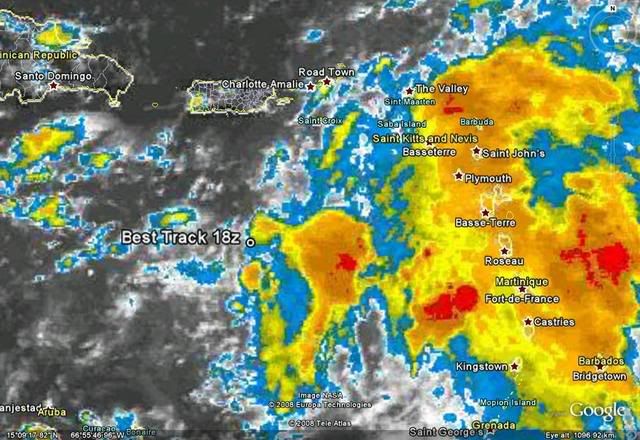
18:00 UTC BEST TRACK update:
AL, 93, 2008092018, , BEST, 0, 156N, 661W, 25, 1009, LO,
AL, 93, 2008092018, , BEST, 0, 156N, 661W, 25, 1009, LO,
0 likes
-
cycloneye
- Admin
- Posts: 149550
- Age: 69
- Joined: Thu Oct 10, 2002 10:54 am
- Location: San Juan, Puerto Rico
Re: ATL INVEST 93L: Discussion
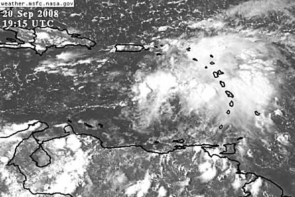
This is moving NW at 315 degrees and has plenty of rain with it.
TCCA21 KNHC 201909
STDECA
SATELLITE TROPICAL DISTURBANCE RAINFALL ESTIMATES
NWS TPC/NATIONAL HURRICANE CENTER MIAMI FL
1815 UTC SAT SEP 20 2008
SYSTEM NAME/IDENTIFIER...CARIBBEAN TROPICAL WAVE
MAX RAINFALL
DATE/TIME LOCATION MOTION MEAN LAST
----------- ------------ ------ ------- -------
20/1815 UTC 15.6N 66.1W 315/07 7.1 IN 5.8 IN
LAST RAINFALL DISTRIBUTION...
DISTANCE LEFT OF CENTER RIGHT OF CENTER
------------- --------------- ---------------
0 TO 1 DEGREE 1.0 TO 2.7 IN 1.2 TO 5.0 IN
1 TO 2 DEGREE 0.0 TO 1.1 IN 3.5 TO 5.8 IN
2 TO 3 DEGREE 0.0 TO 0.1 IN 0.5 TO 3.6 IN
3 TO 4 DEGREE 0.0 TO 0.0 IN 0.0 TO 0.9 IN
...LEGEND...
SYSTEM NAME/IDENTIFIER...NAME OR NUMBER ASSIGNED TO SYSTEM
(E.G. TROPICAL STORM ALPHA, TROPICAL
DISTURBANCE 01, SURFACE TROUGH)
DATE/TIME... DAY OF MONTH AND TIME IN UNIVERSAL TIME
COORDINATES (UTC) IN A DY/HRMN FORMAT
LOCATION... ESTIMATED CENTER OF SYSTEM OR ADVISORY
POSITION FOR TROPICAL CYCLONE IN TENTHS
OF DEGREES OF LATITUDE AND LONGITUDE
MOTION... ESTIMATED DIRECTION AND SPEED OF SYSTEM
IN DEGREES AND KNOTS
MEAN MAXIMUM RAINFALL... THE 24-HOUR MEAN MAXIMUM ACCUMULATION OF
RAINFALL FOR THE SYSTEM IN INCHES BASED
ON FOUR SATELLITE IMAGES SIX HOURS APART
LAST MAXIMUM RAINFALL... THE MAXIMUM ACCUMULATION OF RAINFALL FOR
THE SYSTEM IN INCHES BASED ON THE MOST
RECENT SATELLITE IMAGE
RAINFALL DISTRIBUTION... THE DISTRIBUTION OF RAINFALL WITHIN FOUR
DEGREES (240 NM) LEFT AND RIGHT OF THE
SYSTEM CENTER IN ONE DEGREE (60NM)
INCREMENTS...LOOKING DOWNSTREAM
(1 IN = 25.4 MM)
http://asp1.sbs.ohio-state.edu/tropical/atlantic/obs/
0 likes
-
cycloneye
- Admin
- Posts: 149550
- Age: 69
- Joined: Thu Oct 10, 2002 10:54 am
- Location: San Juan, Puerto Rico
Re: ATL INVEST 93L: Discussion
It looks like a deluge will fall here.
FXCA62 TJSJ 201951
AFDSJU
AREA FORECAST DISCUSSION
NATIONAL WEATHER SERVICE SAN JUAN PR
351 PM AST SAT SEP 20 2008
.DISCUSSION...LATEST VISIBLE SATELLITE IMAGERY SHOWING AN
ELONGATED AREA OF LOW PRESSURE SOUTHEAST OF THE LOCAL FORECAST
AREA THIS AFTERNOON. EXPECT THE ASSOCIATED MOISTURE TO CONTINUE TO
CREEP NORTHWESTWARD TOWARDS THE U.S. VIRGIN ISLANDS AND SECTIONS
OF PUERTO RICO THIS EVENING...AS THE TUTT LOW TO THE NORTH OF THE
ISLANDS CONTINUES TO LIFT AWAY FROM THE LOCAL AREA. BOTH THE NAM
AND GFS MODELS ARE INDICATING VERY DEEP MOISTURE INVADING THE
LOCAL AREA AFTER 00Z THIS EVENING...WITH THE LOW LEVEL FLOW
BECOMING MORE SOUTHEASTERLY. AT THIS TIME...THE BEST MOISTURE AND
DYNAMICS APPEAR TO BE CONVERGING SOUTH OF THE VI AND EASTERN PUERTO
RICO...AND SHOULD BRING INCREASED SHOWER ACTIVITY TO THE LOCAL
CARIBBEAN WATERS AND EASTERN SECTIONS OF THE FORECAST AREA
OVERNIGHT. ONCE THIS INITIAL SURGE OF MOISTURE MOVES ACROSS THE
AREA OVERNIGHT...EXPECT FAIRLY DEEP MOISTURE TO REMAIN ACROSS THE
LOCAL ISLANDS THROUGH THE MIDDLE OF NEXT WEEK. THIS WILL LIKELY
RESULT IN VARIABLY CLOUDY SKIES AND AT LEAST SCATTERED SHOWERS
ACROSS THE LOCAL ISLANDS THROUGH WEDNESDAY OR THURSDAY OR NEXT
WEEK. UPDATED THE FORECAST TO INCREASE PROBABILITY OF PRECIPITATION
FOR FIRST 48 HOURS OR SO OF FORECAST...BUT NO SIGNIFICANT CHANGES
MADE TO THE EXTENDED FORECAST THIS AFTERNOON. WILL CONTINUE TO
MONITOR DEVELOPING CONVECTION ASSOCIATED WITH THIS TROPICAL WAVE
AS A FLASH FLOOD WATCH MAY BECOME NECESSARY FOR THE VI AND EASTERN
SECTIONS OF PUERTO RICO ON SUNDAY IF FURTHER INTENSIFICATION
OCCURS.
http://www.srh.noaa.gov/fwd/productview ... &version=0
0 likes

We got slammed here around 3, very hard rains (I was in a Coastal Zone Management meeting and you could barely hear the speaker for a moment there) thunder, lightning. Now the sun is out and the air is almost dead still. Apparently it's been raining a LOT since I left, there is not a brown spot on the island and despite the mud on the roads (still have sewer trench work going on everywhere) the green is gorgeous.
0 likes


Re: ATL INVEST 93L: Discussion
Well boyz and girlz as I've been saying all along. This thing just will not give up. Convection getting closer to the LLC and circulation continues to get better. The persistance of this thing has been amazing. Once again, me thinks this is gonna be a big one!
0 likes
-
Just Joshing You

- Category 2

- Posts: 512
- Joined: Sat Nov 03, 2007 10:29 am
- Location: Nova Scotia
It's going to dissipate within 24 hours. heard it here first!
Nah it will probably be a depression within 24 hr
Personal Forecast Disclaimer:
The posts in this forum are NOT official forecast and should not be used as such. They are just the opinion of the poster and may or may not be backed by sound meteorological data. They are NOT endorsed by any professional institution or storm2k.org. For official information, please refer to the NHC and NWS products.
0 likes
Who is online
Users browsing this forum: No registered users and 19 guests