
Madagascar: OVERLAND DEPRESSION ex. IVAN (TC 18S)
Moderator: S2k Moderators
-
parvez_savage
- Tropical Low

- Posts: 25
- Joined: Tue Jan 29, 2008 10:17 am
Re: South Indian Ocean: INTENSE TROPICAL CYCLONE IVAN (TC 18S)
The best i have seen in 2008....

0 likes

-
parvez_savage
- Tropical Low
- Posts: 25
- Joined: Tue Jan 29, 2008 10:17 am
Re: South Indian Ocean: INTENSE TROPICAL CYCLONE IVAN (TC 18S)
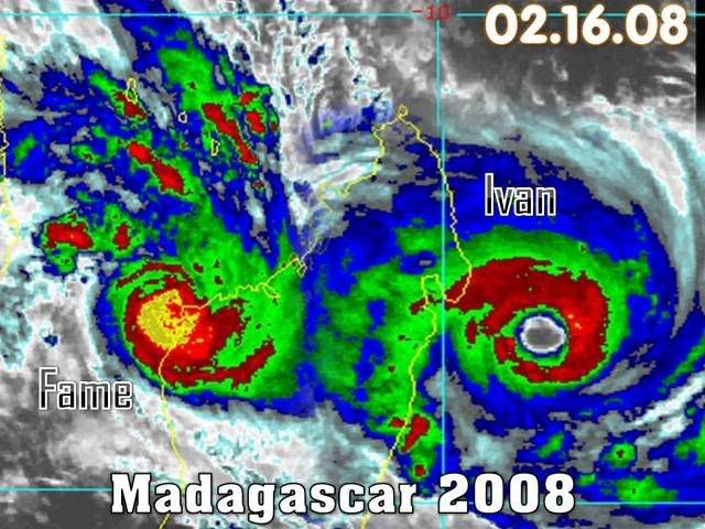
2008 16 Feb 1530z: TC 18S/IVAN: South Indian Ocean Area, Mascarenes islands area.
Centre loc: near 16.4s and 51.9e at 12z(JTWC).
MOVEMENT PAST SIX HOURS(up to 06z) - 255 DEGREES AT 07 KTS.
Max winds(1mn): 115kts(T6.0)(12z/JTWC).
CATEGORY(Australian):4
Intensifying.
SATELLITE DATA:
Met7(57.5e) 1km wv, NRL: Ste Marie island(17.1s and 49.8e) is about to be hit by the active core of this cyclone. Conditions are set to deteriorate markedly within the next 6h.
0 likes


Madagascar's in for it.
676
WTIO30 FMEE 161209
RSMC / TROPICAL CYCLONE CENTRE / LA REUNION
TROPICAL CYCLONE FORECAST WARNING (SOUTH-WEST INDIAN OCEAN)
0.A WARNING NUMBER : 38/11/20072008
1.A INTENSE TROPICAL CYCLONE 11 (IVAN)
2.A POSITION 2008/02/16 AT 1200 UTC :
16.5S / 51.9E
(SIXTEEN DECIMAL FIVE DEGREES SOUTH AND FIFTY ONE DECIMAL NINE DEGREES
EAST)
3.A DVORAK ANALYSIS : 5.5/5.5 /D 1.0/24 H
4.A CENTRAL PRESSURE : 941 HPA
5.A MAX AVERAGE WIND SPEED (10 MN) : 90 KT
6.A EXTENSION OF WINDS BY QUADRANTS (KM):
30 KT NE: 400 SE: 400 SO: 300 NO: 200
50 KT NE: 080 SE: 080 SO: 080 NO: 080
7.A FIRST CLOSED ISOBARE (PRESSURE / AVERAGE DIAM): 1000 HPA / 600 KM
8.A VERTICAL EXTENSION OF CYCLONE CIRCULATION: DEEP
1.B FORECASTS:
12H: 2008/02/17 00 UTC: 17.0S/50.9E, MAX WIND=100KT, INTENSE TROP. CYCL..
24H: 2008/02/17 12 UTC: 17.6S/49.4E OVERLAND.
36H: 2008/02/18 00 UTC: 18.3S/48.3E OVERLAND.
48H: 2008/02/18 12 UTC: 19.2S/47.4E OVERLAND.
60H: 2008/02/19 00 UTC: 19.9S/46.7E OVERLAND.
72H: 2008/02/19 12 UTC: 20.8S/46.4E OVERLAND.
2.B OTHER INFORMATIONS:
T AND CI=5.5
IVAN IS INTESIFYING, WITH AN EYE OF 30 NM DIAMETER CONSOLIDATING WITHIN A
FAVORABLE ENVIRONMENT (HIGH OCEAN HEAT CONTAIN AND DECREASING SHEAR).
IT IS EXPECTED TO INCURVED WESTSOUTHWESTWARDS IN THE NEXT HOURS, OVER THE
NORTHERN EDGE OF THE SUBTROPICAL RIDGE TOWARDS MALAGASY COASTS.
IVAN IS A SERIOUS THREAT FOR THE CENTRAL EAST COAST OF MADAGASCAR. IT IS
EXPECTED TO LAND FALL IN THE VINICITY OF TAMATAVE TOMORROW AFTERNOON.
0 likes

-
parvez_savage
- Tropical Low
- Posts: 25
- Joined: Tue Jan 29, 2008 10:17 am
Re: South Indian Ocean: INTENSE TROPICAL CYCLONE IVAN (TC 18S)
Ivan eye position report.
16/1530z 16.6°S 51.4°E +14.6°C
16/1600z 16.7°S 51.4°E +14.7°C
At 16/1600z eye of TC Ivan was at 150 kms 081° from Ste Marie.
16/1530z 16.6°S 51.4°E +14.6°C
16/1600z 16.7°S 51.4°E +14.7°C
At 16/1600z eye of TC Ivan was at 150 kms 081° from Ste Marie.
0 likes
-
parvez_savage
- Tropical Low
- Posts: 25
- Joined: Tue Jan 29, 2008 10:17 am
Re: South Indian Ocean: INTENSE TROPICAL CYCLONE IVAN (TC 18S)
2008 16 Feb 1800z: TC 18S/IVAN: South Indian Ocean Area, Mascarenes islands area.
Centre loc: near 16.7s and 51.2e at 17z(Met7).
Max winds(1mn): 115kts(T6.0)(12z/JTWC).
CATEGORY(Australian):4
Intensifying.
SATELLITE DATA:
F16 91h 1638z , NRL: an very active band(yellow and red) is bearing down on Ste Marie island(17.1s and 49.8e). Conditions are set to deteriorate markedly within the next 6h.
0 likes
-
P.K.

- Professional-Met

- Posts: 5149
- Joined: Thu Sep 23, 2004 5:57 pm
- Location: Watford, England
- Contact:
Re: South Indian Ocean: INTENSE TROPICAL CYCLONE IVAN (TC 18S)
Up to 100kts with 110kts forecast before landfall.
WTIO30 FMEE 161827
RSMC / TROPICAL CYCLONE CENTRE / LA REUNION
TROPICAL CYCLONE FORECAST WARNING (SOUTH-WEST INDIAN OCEAN)
0.A WARNING NUMBER : 39/11/20072008
1.A INTENSE TROPICAL CYCLONE 11 (IVAN)
2.A POSITION 2008/02/16 AT 1800 UTC :
WITHIN 20 NM RADIUS OF POINT 16.7S / 51.1E
(SIXTEEN DECIMAL SEVEN DEGREES SOUTH AND FIFTY ONE DECIMAL ONE DEGREES
EAST)
3.A DVORAK ANALYSIS : 6.0/6.0 /D 1.5/24 H
4.A CENTRAL PRESSURE : 930 HPA
5.A MAX AVERAGE WIND SPEED (10 MN) : 100 KT
6.A EXTENSION OF WINDS BY QUADRANTS (KM):
30 KT NE: 400 SE: 400 SO: 300 NO: 200
50 KT NE: 130 SE: 130 SO: 080 NO: 080
7.A FIRST CLOSED ISOBARE (PRESSURE / AVERAGE DIAM): 1004 HPA / 700 KM
8.A VERTICAL EXTENSION OF CYCLONE CIRCULATION: DEEP
1.B FORECASTS:
12H: 2008/02/17 06 UTC: 17.1S/49.9E, MAX WIND=110KT, INTENSE TROP. CYCL..
24H: 2008/02/17 18 UTC: 17.6S/48.3E, MAX WIND=040KT, OVERLAND.
36H: 2008/02/18 06 UTC: 18.4S/46.5E, MAX WIND=020KT, OVERLAND.
48H: 2008/02/18 18 UTC: 18.8S/45.9E, MAX WIND=020KT, OVERLAND.
60H: 2008/02/19 06 UTC: 19.7S/45.6E, MAX WIND=015KT, OVERLAND.
72H: 2008/02/19 18 UTC: 21.1S/44.3E, MAX WIND=015KT, OVERLAND.
2.B OTHER INFORMATIONS:
T=6.0- AND CI=6.0-
IVAN IS INTENSIFYING PROGRESSIVELY SINCE 48 HOURS WITHIN A FAVOURABLE
ENVIRONMENT.
DESPITE 1200Z AND 1330Z METEOSAT7 ENHANCED INFRARED SHOWS PONCTUALLY A
T-NUMBER AT 6.5, LARGE EYE (MORE THAN 45NM DIAMETER ON INFRARED IMAGERY)
BETWEEN 1400Z AND 1530Z DIDN'T ALLOW MAKING POSITIVE ADJUSTMENT ANYMORE.
FINAL T-NUMBER IS THEREFORE AN AVERAGE BETWEEN 1200Z AND 1800Z.
IT IS EXPECTED TO KEEPS ON TRACKING GLOBALLY WEST-SOUTHWESTWARDS ON THE
NORTHERN EDGE OF THE SUBTROPICAL HIGH PRESSURES.
HURRICANE IS FORECASTED TO MAKE ITS LANDFALL NEAR THE HARBOR CITY OF
TAMATAVE (A LITTLE BIT IN ITS NORTH) ON SUNDAY BETWEEN 0600Z AND 0900Z
WITH MAXIMUM 10MN AVERAGE WINDS IN THE EYEWALL AT ABOUT 110KT WITH GUSTS
UP TO 155 KT.
HURRICANE FORCE WINDS SHOULD CONCERN THE ISLAND OF SAINTE-MARIE BEFORE
0300Z.
0 likes
-
parvez_savage
- Tropical Low
- Posts: 25
- Joined: Tue Jan 29, 2008 10:17 am
Re: South Indian Ocean: INTENSE TROPICAL CYCLONE IVAN (TC 18S)
2008 16 Feb 1830z: TC 18S/IVAN: South Indian Ocean Area, Mascarenes islands area.
Centre loc: near 16.7s and 51.1e at 18z(Met7).
Max winds(1mn): 120kts(T6.0+)(KH,PH).
CATEGORY(Australian):4
Intensifying.
SATELLITE DATA:
Met7(57.5e) hres nhccol 18z,:system does appear to have peaked just below category 5(AUST).Internal structure is beginning to be impacted by landmass. Met7 depicts warming tops and core getting less tight. Best satellite presentation was obtained near 15z.
However a favourable tongue of OHC near the coast may allow the system to stay steady intensity-wise while an improvement in satellite signature may be observed just before landfall.
0 likes

-
Crostorm

- Category 5

- Posts: 2060
- Age: 51
- Joined: Mon Dec 25, 2006 3:51 pm
- Location: Croatia-Europe
- Contact:
Re: South Indian Ocean: INTENSE TROPICAL CYCLONE IVAN (TC 18S)
Very intense tropical cyclone Ivan is forecast to strike Madagascar at about 00:00 GMT on 17 February. Data supplied by the US Navy and Air Force Joint Typhoon Warning Center suggest that the point of landfall will be near 16.7 S, 50.3 E. Ivan is expected to bring 1-minute maximum sustained winds to the region of around 212 km/h (132 mph). Wind gusts in the area may be considerably higher.
According to the Saffir-Simpson damage scale the potential property damage and flooding from a storm of Ivan's strength (category 4) at landfall includes:
* Storm surge generally 4.0-5.5 metres (13-18 feet) above normal.
* Curtainwall failures with some complete roof structure failures on small residences.
* Shrubs, trees, and all signs are blown down.
* Complete destruction of mobile homes.
* Extensive damage to doors and windows.
* Low-lying escape routes may be cut by rising water 3-5 hours before arrival of the centre of the storm.
* Major damage to lower floors of structures near the shore.
* Terrain lower than 3 metres (10 feet) above sea level may be flooded requiring massive evacuation of residential areas as far inland as 10 km (6 miles).
There is also the potential for flooding further inland due to heavy rain.
The information above is provided for guidance only and should not be used to make life or death decisions or decisions relating to property. Anyone in the region who is concerned for their personal safety or property should contact their official national weather agency or warning centre for advice.
This alert is provided by Tropical Storm Risk (TSR) which is sponsored by Benfield, Royal & SunAlliance, Crawford & Company and University College London (UCL). TSR acknowledges the support of the UK Met Office.
0 likes


 Rainfall intensity

-
Pedro Fernández

- Tropical Storm

- Posts: 233
- Age: 48
- Joined: Mon Dec 31, 2007 7:24 am
- Location: Costa Tropical (Granada, Spain).
- Contact:
-
Squarethecircle
- Category 5
- Posts: 2165
- Joined: Fri Oct 19, 2007 4:00 pm
- Location: Fairfax, VA
Looks like the east eyewall is falling apart now. I'd estimate intensity still at 115 knots. While I was away, I'd guess the peak at 125 knots. This storm was almost as nice as Hondo! Bravo, Ivan, bravo!
And yet, missing this, I feel very empty inside...
Also, as you can see from that image, the eye is very, very wide, at least relatively. Reminds me of another storm we had in this basin not to long ago. Which I also mentioned earlier in this post.
Well, this has been a fun storm. For fun, compare some of the images on this page to those on the top of page 7.
0 likes
Who is online
Users browsing this forum: No registered users and 27 guests