NW Australia: Tropical Cyclone Nicholas (19S)
Moderator: S2k Moderators
-
HURAKAN

- Professional-Met

- Posts: 46084
- Age: 39
- Joined: Thu May 20, 2004 4:34 pm
- Location: Key West, FL
- Contact:

Australian Government Bureau of Meteorology
Western Australia
Media: The Standard Emergency Warning Signal should NOT be used with this
warning.
TOP PRIORITY FOR IMMEDIATE BROADCAST
TROPICAL CYCLONE ADVICE NUMBER 74
Issued at 12:55 pm WDT on Wednesday, 20 February 2008
BY THE BUREAU OF METEOROLOGY
TROPICAL CYCLONE WARNING CENTRE PERTH
A Cyclone WARNING is current for coastal areas from Coral Bay to Carnarvon.
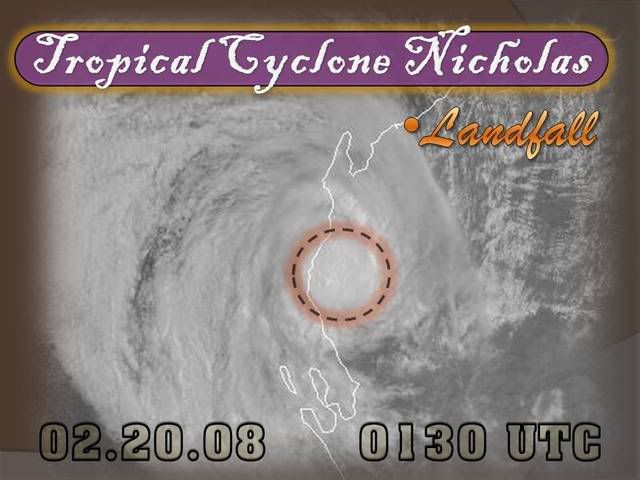
At 12:00 pm WDT Tropical Cyclone Nicholas was estimated to be
110 kilometres north of Carnarvon and
85 kilometres south of Coral Bay and
moving south at 15 kilometres per hour.
Tropical Cyclone Nicholas has crossed the coast this morning and is likely to
weaken further today as it continues to track south over land. DAMAGING winds
with gusts to 90 kilometres per hour are possible between Coral Bay and
Carnarvon this afternoon, however winds are then likely to ease.
Heavy rain with falls in excess of 100 millimetres is likely to cause local
flooding in areas south of the system today and continuing overnight.
Details of Tropical Cyclone Nicholas at 12:00 pm WDT:
Centre located near...... 23.9 degrees South 113.7 degrees East
Location accuracy........ within 45 kilometres
Recent movement.......... towards the south at 15 kilometres per hour
Wind gusts near centre... 95 kilometres per hour
Severity category........ 1
Central pressure......... 986 hectoPascals
FESA-State Emergency Service advises of the following community alerts:
BLUE ALERT: People in or near coastal communities between Cape Cuvier and
Carnarvon including Carnarvon should be taking precautions.
ALL CLEAR WITH CAUTION: People in or near Coral Bay are advised to proceed with
caution.
The next advice will be issued by 4:00 pm WDT Wednesday 20 February.Cyclone
advices and State Emergency Service Community Alerts are available by
dialling 1300 659 210

0 likes


Re: NW Australia: Tropical Cyclone Nicholas (19S)
IDW24200
Australian Government Bureau of Meteorology
Western Australia
Media: The Standard Emergency Warning Signal should NOT be used with this
warning.
PRIORITY
TROPICAL CYCLONE ADVICE NUMBER 75
Issued at 4:05 pm WDT on Wednesday, 20 February 2008
BY THE BUREAU OF METEOROLOGY
TROPICAL CYCLONE WARNING CENTRE PERTH
The Cyclone WARNING from Coral Bay to Carnarvon has been cancelled.
At 3:00 pm WDT Ex-Tropical Cyclone Nicholas was estimated to be
44 kilometres north northeast of Carnarvon and
moving south at 15 kilometres per hour.
Tropical Cyclone Nicholas crossed the coast this morning and has now weakened
below tropical cyclone intensity as it continues to track south over land.
Damaging winds are no longer expected.
However, heavy rain with falls in excess of 100 millimetres is likely to
continue south of the system overnight and into Thursday which and may cause
local flooding.
Details of Ex-Tropical Cyclone Nicholas at 3:00 pm WDT:
Centre located near...... 24.5 degrees South 113.8 degrees East
Location accuracy........ within 45 kilometres
Recent movement.......... towards the south at 15 kilometres per hour
Wind gusts near centre... 85 kilometres per hour
Severity category........ below cyclone intensity
Central pressure......... 990 hectoPascals
FESA-State Emergency Service advises of the following community alerts:
ALL CLEAR WITH CAUTION: People in Carnarvon are advised to proceed with caution.
No further advices are expected to be issued for this system.
Cyclone advices and State Emergency Service Community Alerts are available by
dialling 1300 659 210
A map showing the track of the cyclone is available at:
http://www.bom.gov.au/weather/cyclone
0 likes


AXAU02 APRF 200716
IDW27700
TROPICAL CYCLONE TECHNICAL BULLETIN: AUSTRALIA - WESTERN REGION
Issued by PERTH TROPICAL CYCLONE WARNING CENTRE
at: 0716 UTC 20/02/2008
Name: Nicholas
Data At: 0600 UTC
Latitude: 24.5S
Longitude: 113.8E
Location Accuracy: within 24 nm [45 km]
Movement Towards: south [177 deg]
Speed of Movement: 8 knots [15 km/h]
Maximum 10-Minute Wind: 30 knots [55 km/h]
Maximum 3-Second Wind Gust: 45 knots [85 km/h]
Central Pressure: 990 hPa
Radius of 34-knot winds NE quadrant:
Radius of 34-knot winds SE quadrant:
Radius of 34-knot winds SW quadrant:
Radius of 34-knot winds NW quadrant:
Radius of 48-knot winds NE quadrant:
Radius of 48-knot winds SE quadrant:
Radius of 48-knot winds SW quadrant:
Radius of 48-knot winds NW quadrant:
Radius of 64-knot winds:
Radius of Maximum Winds:
Dvorak Intensity Code: T2.5/3.0/W0.5/12HRS
Pressure of outermost isobar: 1000 hPa
Radius of outermost closed isobar: 140 nm [260 km]
Storm Depth: Medium
FORECAST DATA
Date/Time : Location : Loc. Accuracy: Max Wind : Central Pressure
[UTC] : degrees : nm [km]: knots[km/h]: hPa
+12: 20/1800: 25.6S 114.1E: 035 [065]: 030 [055]: 990
+24: 21/0600: 26.2S 114.3E: 055 [100]: 030 [055]: 994
+36: 21/1800: 26.4S 114.2E: 100 [185]: 025 [045]: 996
+48: 22/0600: 26.4S 113.7E: 150 [280]: 025 [045]: 996
+60: 22/1800: 25.9S 112.5E: 190 [350]: 025 [045]: 996
+72: 23/0600: 25.8S 111.1E: 240 [445]: 025 [045]: 996
REMARKS:
Tropical Cyclone Nicholas crossed the coast this morning and has now weakened
below tropical cyclone intensity as it continues to track south over land.
Dvorak intensity indicates a CI of 3.0 is maintained however actual intensity is
downgraded being over land. Marine gales remain possible in the strong SSE
pressure gradient associated with a strong ridge to the south.
The system is likely to continue on a general southerly course in the next 24
hours.
Heavy rain with falls in excess of 100 millimetres is likely to continue south
of the system overnight and into Thursday which and may cause local flooding. ==
The next bulletin for this system will be issued by: 20/1300 UTC by Perth TCWC.
0 likes
Who is online
Users browsing this forum: No registered users and 11 guests