
GFDL has done a reasonably good job with this storm.
It is going to be interesting to watch the 00Z runs come out later tonight.
ATL Tropical Depression GUSTAV - Model Runs
Moderator: S2k Moderators

Re: ATL: Hurricane Gustav-Model Runs
It's not good that the models are lining this up just west of NO because, as Fay showed, storms can tend to veer east at the last moment in the Gulf. (I know about the High etc) - Just saying.
0 likes
-
Stormcenter
- S2K Supporter

- Posts: 6689
- Joined: Wed Sep 03, 2003 11:27 am
- Location: Houston, TX
Re: ATL: Hurricane Gustav-Model Runs
cycloneye wrote:Is the first time that SHIP forecasts a cat 3 for Gustav.
WHXX01 KWBC 300030
CHGHUR
TROPICAL CYCLONE GUIDANCE MESSAGE
NWS TPC/NATIONAL HURRICANE CENTER MIAMI FL
0030 UTC SAT AUG 30 2008
DISCLAIMER...NUMERICAL MODELS ARE SUBJECT TO LARGE ERRORS.
PLEASE REFER TO NHC OFFICIAL FORECASTS FOR TROPICAL CYCLONE
AND SUBTROPICAL CYCLONE INFORMATION.
ATLANTIC OBJECTIVE AIDS FOR
TROPICAL CYCLONE GUSTAV (AL072008) 20080830 0000 UTC
...00 HRS... ...12 HRS... ...24 HRS. .. ...36 HRS...
080830 0000 080830 1200 080831 0000 080831 1200
LAT LON LAT LON LAT LON LAT LON
BAMS 19.2N 80.0W 20.6N 82.5W 21.8N 84.6W 22.9N 86.3W
BAMD 19.2N 80.0W 20.5N 82.0W 22.1N 84.1W 23.6N 86.0W
BAMM 19.2N 80.0W 20.3N 82.2W 21.5N 84.1W 22.9N 85.8W
LBAR 19.2N 80.0W 20.6N 81.8W 22.3N 83.8W 24.1N 85.6W
SHIP 70KTS 83KTS 92KTS 98KTS
DSHP 70KTS 83KTS 81KTS 95KTS
...48 HRS... ...72 HRS... ...96 HRS. .. ..120 HRS...
080901 0000 080902 0000 080903 0000 080904 0000
LAT LON LAT LON LAT LON LAT LON
BAMS 24.1N 87.4W 27.7N 89.7W 31.0N 92.5W 31.6N 95.0W
BAMD 25.1N 87.8W 28.3N 91.2W 30.8N 93.0W 31.3N 93.8W
BAMM 24.3N 87.3W 27.7N 90.2W 30.4N 92.1W 31.0N 93.3W
LBAR 25.8N 87.0W 28.4N 89.7W 29.9N 91.6W 31.7N 93.9W
SHIP 103KTS 100KTS 83KTS 65KTS
DSHP 99KTS 96KTS 50KTS 29KTS
...INITIAL CONDITIONS...
LATCUR = 19.2N LONCUR = 80.0W DIRCUR = 300DEG SPDCUR = 8KT
LATM12 = 18.3N LONM12 = 78.4W DIRM12 = 300DEG SPDM12 = 8KT
LATM24 = 17.8N LONM24 = 77.0W
WNDCUR = 70KT RMAXWD = 20NM WNDM12 = 55KT
CENPRS = 975MB OUTPRS = 1006MB OUTRAD = 250NM SDEPTH = D
RD34NE = 140NM RD34SE = 120NM RD34SW = 90NM RD34NW = 120NM

This my fellow posters is called "model consensus".
0 likes

Re: ATL: Hurricane Gustav-Model Runs
Stormcenter wrote:cycloneye wrote:Is the first time that SHIP forecasts a cat 3 for Gustav.
WHXX01 KWBC 300030
CHGHUR
TROPICAL CYCLONE GUIDANCE MESSAGE
NWS TPC/NATIONAL HURRICANE CENTER MIAMI FL
0030 UTC SAT AUG 30 2008
DISCLAIMER...NUMERICAL MODELS ARE SUBJECT TO LARGE ERRORS.
PLEASE REFER TO NHC OFFICIAL FORECASTS FOR TROPICAL CYCLONE
AND SUBTROPICAL CYCLONE INFORMATION.
ATLANTIC OBJECTIVE AIDS FOR
TROPICAL CYCLONE GUSTAV (AL072008) 20080830 0000 UTC
...00 HRS... ...12 HRS... ...24 HRS. .. ...36 HRS...
080830 0000 080830 1200 080831 0000 080831 1200
LAT LON LAT LON LAT LON LAT LON
BAMS 19.2N 80.0W 20.6N 82.5W 21.8N 84.6W 22.9N 86.3W
BAMD 19.2N 80.0W 20.5N 82.0W 22.1N 84.1W 23.6N 86.0W
BAMM 19.2N 80.0W 20.3N 82.2W 21.5N 84.1W 22.9N 85.8W
LBAR 19.2N 80.0W 20.6N 81.8W 22.3N 83.8W 24.1N 85.6W
SHIP 70KTS 83KTS 92KTS 98KTS
DSHP 70KTS 83KTS 81KTS 95KTS
...48 HRS... ...72 HRS... ...96 HRS. .. ..120 HRS...
080901 0000 080902 0000 080903 0000 080904 0000
LAT LON LAT LON LAT LON LAT LON
BAMS 24.1N 87.4W 27.7N 89.7W 31.0N 92.5W 31.6N 95.0W
BAMD 25.1N 87.8W 28.3N 91.2W 30.8N 93.0W 31.3N 93.8W
BAMM 24.3N 87.3W 27.7N 90.2W 30.4N 92.1W 31.0N 93.3W
LBAR 25.8N 87.0W 28.4N 89.7W 29.9N 91.6W 31.7N 93.9W
SHIP 103KTS 100KTS 83KTS 65KTS
DSHP 99KTS 96KTS 50KTS 29KTS
...INITIAL CONDITIONS...
LATCUR = 19.2N LONCUR = 80.0W DIRCUR = 300DEG SPDCUR = 8KT
LATM12 = 18.3N LONM12 = 78.4W DIRM12 = 300DEG SPDM12 = 8KT
LATM24 = 17.8N LONM24 = 77.0W
WNDCUR = 70KT RMAXWD = 20NM WNDM12 = 55KT
CENPRS = 975MB OUTPRS = 1006MB OUTRAD = 250NM SDEPTH = D
RD34NE = 140NM RD34SE = 120NM RD34SW = 90NM RD34NW = 120NM
This my fellow posters is called "model consensus".
And it looks like Gus will be a TS in my neck of the woods at the end of that forecast
0 likes

>>not by much...and the BAMM suite is worthless this far out. Personally, I would stick with the the more reliable models......
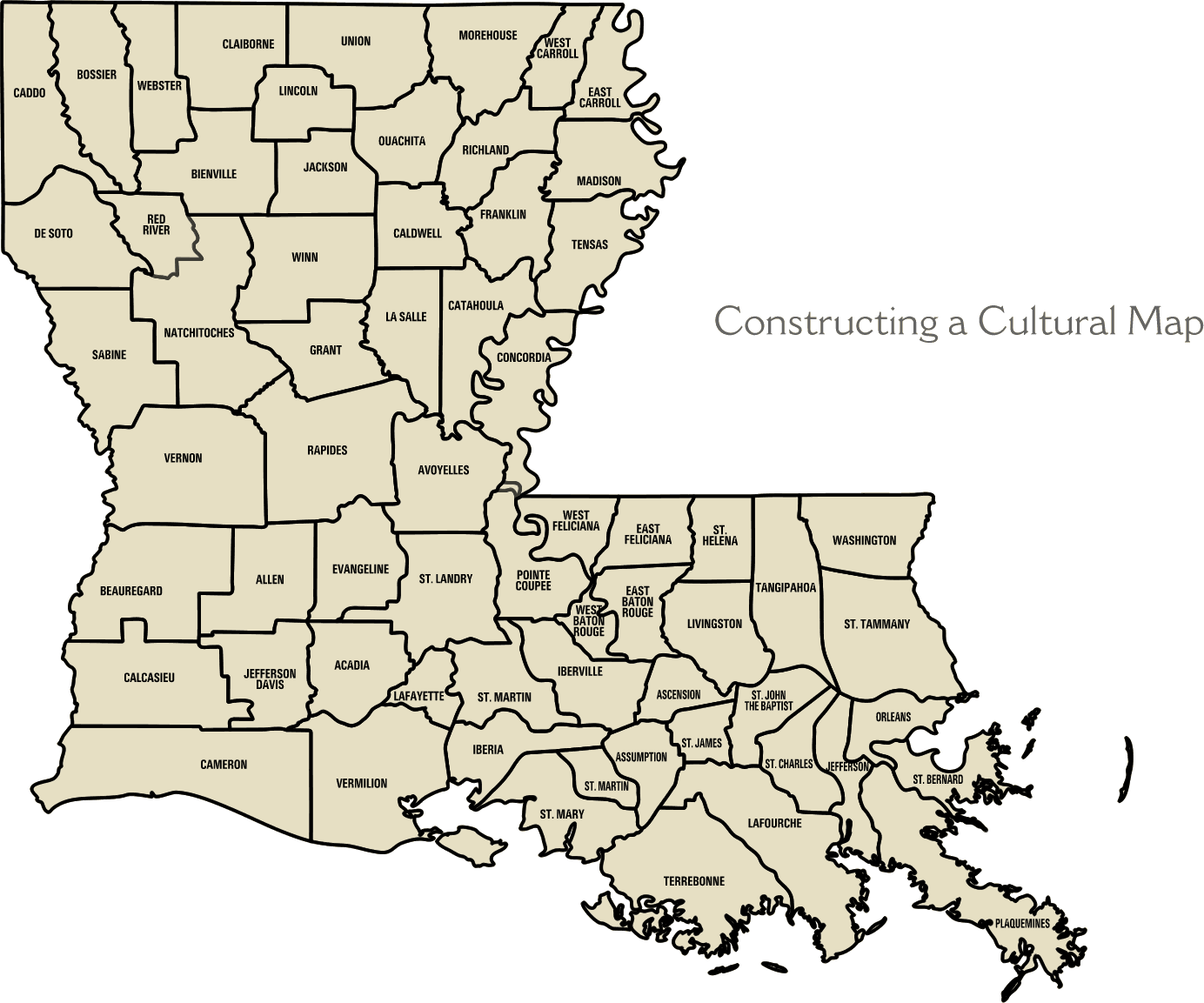
Considering it's pretty much with the consensus, it looks like they are seeing what the globals are seeing - for the most part. Looks like the majority hit between lower Lafourche, Terrebonne, St. Mary, Iberia, Vermillion, Cameron Parishes. Here's a map of the coastal Parishes.
http://www.louisianafolklife.org/images/culturalmap.gif
We have just over 100,000 people in Lafourche which runs from the Gulf (Port Fourchon) to Thibodaux along Bayou Lafourche (former branch of the MS at some point).
Terrebonne Parish also has about 100,000 people and includes Cocodrie, Houma, Dulac, Montegut - much of the Parish is low.
St. Mary runs with Bayou Teche, Atchafalaya and Belle River and includes Morgan City, Franklin, Baldwin, Patterson, Berwick. They have about 55,000 people there, and most of that area is low lying (some damage during Lili and Rita).
Iberia Parish includes the town of New Iberia and Jeanerette and has about 75,000 people.
Vermillion Parish also has about 55,000 people and includes Delcambre, Abbeville, Intracoastal City and Maurice. This area got hit pretty hard by Rita.
Finally Cameron Parish borders Texas. It got mostly wiped out by Rita, and I haven't been back since. There are probably anywhere from several hundred to a few thousand people still living down that way. Mostly there are a lot of rice terraces, wetlands, a wildlife preserve and fishing. It's a good way of life down there, but they are susceptible to storms hitting in the Western Gulf.
So there are probably over 400,000 people in the coastal Parishes with a couple of million more in the communities and Parishes that are more off those coastal areas (Lafayette, Lake Charles, etc.). Roads are gonna be congested should the models continue to focus on these areas.
Steve
0 likes
-
LAwxrgal

- S2K Supporter
- Posts: 1763
- Joined: Tue Jul 06, 2004 1:05 pm
- Location: Reserve, LA (30 mi west of NOLA)
Re: ATL: Hurricane Gustav-Model Runs
Unlike Katrina or Rita, this evac looks to encompass pretty much all of the southern Louisiana coast.
0 likes
-
Stratosphere747
- Category 5

- Posts: 3772
- Joined: Thu Sep 11, 2003 8:34 pm
- Location: Surfside Beach/Freeport Tx
- Contact:

-
Innotech

- Category 5
- Posts: 1031
- Joined: Mon Aug 30, 2004 5:32 pm
- Location: Lafayette, Louisiana
- Contact:
Re: ATL: Hurricane Gustav-Model Runs
that is a seriously crappy model consensus. right over my house. Should be an interesting day.
0 likes
-
Ed Mahmoud
Re: ATL: Hurricane Gustav-Model Runs
The old Highway 90 that ran past the J Ray McDermott yard would have several inches of standing water on it during the Spring when the snow melt from the Ohio River was diverted down the Atchafalaya.
Thank goodness the new Highway 90 is multiple lanes and elevated through the low lying parts of St Mary parish.
Thank goodness the new Highway 90 is multiple lanes and elevated through the low lying parts of St Mary parish.
0 likes

-
Ed Mahmoud
Re:
SCUBAdude wrote:So what time Central should I look at the models to see how they turn out with the recon data in them? I'm not to savy with the time conversions and all.
SD.
I heard the 6Z models, which run around 1 am, and the data starts showing up on the internet between 5 am and 7 am, CDT. NAM a little earlier. But the NAM isn't well thought of.
0 likes
-
Matthew Williams
- Tropical Low

- Posts: 20
- Joined: Wed Aug 24, 2005 8:31 pm
- Contact:
-
Ed Mahmoud
Re:
Matthew Williams wrote:Ed, even though you admit you are an amateur, I love your reasoning. Do you have any opinions on what to expect on future models? A trend East, stay the same, or....
I am not sure. But the GFDL has been rather stable for about 2 days, a very slow drift eastward from West of New Orleans to East of New orleans closer to BIX, and the last run a tiny bit back West of MSY, worst case type scenario, a Cat 4 just SW of the city. The fact that the GFDL has been stable suggests to me it is generally on the right track, but a slight drift further West, maybe as far West as Vermillion Parish, wouldn't surprise me.
Really waiting to see what the morning models show, after some of the G-IV data has been incorporated, and the models are better initialized as to the features over the Gulf.
0 likes
-
Matthew Williams
- Tropical Low
- Posts: 20
- Joined: Wed Aug 24, 2005 8:31 pm
- Contact:
-
Ed Mahmoud
Re: ATL: Hurricane Gustav-Model Runs
Matthew Williams wrote:Thanks Ed . Do you (or any other Pro Met) know if the Data from the G-IV has been looked over by the forecasters at the NHC so they can begin discounting models and what not?
Pro-met Delta Dog (sp?) had seen some of it, so I strongly suspect NHC has as well.
0 likes
-
haml8

- Tropical Storm

- Posts: 188
- Age: 50
- Joined: Sun Aug 19, 2007 10:03 pm
- Location: Katy, Texas
- Contact:
Re: ATL: Hurricane Gustav-Model Runs
Can someone please post the steering currents that are likley to effect Gustav?
Thanks in advance
Thanks in advance
0 likes
-
DESTRUCTION5

- Category 5
- Posts: 4430
- Age: 44
- Joined: Wed Sep 03, 2003 11:25 am
- Location: Stuart, FL
GFS rollin...dont like how it started gus below jamica?
http://www.nco.ncep.noaa.gov/pmb/nwprod ... loop.shtml
http://www.nco.ncep.noaa.gov/pmb/nwprod ... loop.shtml
0 likes
Who is online
Users browsing this forum: No registered users and 98 guests