ATL HANNA: Extratropical - Discussion

Moderator: S2k Moderators

Message
Author
cpdaman
Category 5
Category 5
Posts: 3131
Joined: Sat Jun 10, 2006 11:44 am
Location: SPB county (gulf stream)

Re: ATL: Hurricane Hanna in SE Bahamas

#2301 Postby cpdaman » Mon Sep 01, 2008 2:33 pm

El Nino wrote:
cpdaman wrote:down to 983.3 at station.....................SW winds howling

http://www.wunderground.com/weatherstat ... =IPINECAY2


106 km/h, 983mb is NOT the min pressure !


right but i don't think it goes much lower (they gotta be close to the center) i hope for there sake!

and the flatter wind field seemed to match the time about an hour ago when i posted about her being elongated more w-e, since then it has taken a more circular appearance , especially on east side
0 likes   

User avatar
storms in NC
S2K Supporter
S2K Supporter
Posts: 2338
Joined: Thu Jul 28, 2005 2:58 pm
Location: Wallace,NC 40 miles NE of Wilm
Contact:

Re:

#2302 Postby storms in NC » Mon Sep 01, 2008 2:37 pm

HURAKAN wrote:191630 2214N 07224W 8427 01364 9832 +223 +170 025006 008 020 002 00
191700 2213N 07223W 8430 01361 9832 +221 +170 317003 004 021 002 03

extra 983 mb


:eek: :eek:
0 likes   

cpdaman
Category 5
Category 5
Posts: 3131
Joined: Sat Jun 10, 2006 11:44 am
Location: SPB county (gulf stream)

Re: ATL: Hurricane Hanna in SE Bahamas

#2303 Postby cpdaman » Mon Sep 01, 2008 2:38 pm

she appears to be expanding in the last half hour

http://adds.aviationweather.gov/satelli ... g&itype=ir

hopefully some more shear can streak over her soon
0 likes   

User avatar
HURAKAN
Professional-Met
Professional-Met
Posts: 46086
Age: 38
Joined: Thu May 20, 2004 4:34 pm
Location: Key West, FL
Contact:

#2304 Postby HURAKAN » Mon Sep 01, 2008 2:39 pm

URNT15 KNHC 011937
AF301 0208A HANNA HDOB 37 20080901
192630 2213N 07148W 8425 01406 9917 +155 +155 172054 064 068 035 00
192700 2213N 07146W 8413 01417 9922 +147 +147 165074 088 073 039 00
192730 2213N 07145W 8420 01412 9925 +149 +149 165082 087 077 035 03
192800 2213N 07143W 8437 01409 9936 +146 +146 161073 076 075 040 00
192830 2213N 07142W 8427 01423 9946 +137 +137 149081 083 072 041 00
192900 2213N 07141W 8417 01429 9947 +134 +134 148081 083 073 041 00
192930 2213N 07139W 8409 01443 9949 +131 +131 149079 082 071 040 00
193000 2213N 07138W 8403 01445 9949 +129 +129 151085 086 071 038 00
193030 2213N 07137W 8422 01426 9951 +130 +130 151084 087 072 038 00
193100 2213N 07135W 8430 01429 9961 +129 +129 152083 085 070 038 00
193130 2213N 07134W 8424 01443 9968 +128 +128 146084 087 067 036 00
193200 2213N 07133W 8418 01447 9970 +127 +127 146078 081 064 038 00
193230 2213N 07132W 8418 01450 9972 +126 +126 145080 080 064 036 00
193300 2213N 07131W 8422 01451 9975 +125 +125 146078 079 062 035 00
193330 2213N 07129W 8427 01443 9979 +125 +125 151080 082 062 030 00
193400 2213N 07128W 8431 01441 9981 +126 +126 152078 082 061 025 00
193430 2213N 07127W 8429 01448 9986 +126 +126 152078 080 999 999 03
193500 2214N 07125W 8440 01440 9988 +130 +130 154079 080 999 999 03
193530 2216N 07125W 8447 01438 9990 +133 +133 147078 080 999 999 03
193600 2218N 07126W 8436 01447 9981 +145 +145 145081 083 058 009 03

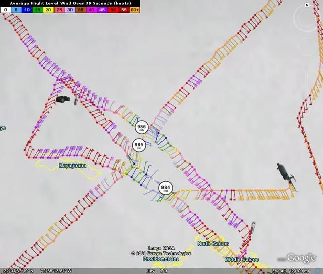
Look how many FL winds in the 80-knot range. :eek:
0 likes   

Scorpion

#2305 Postby Scorpion » Mon Sep 01, 2008 2:41 pm

Wow.. unbelievable. Just strengthening in the face of shear.
0 likes   

Brent
S2K Supporter
S2K Supporter
Posts: 38099
Age: 37
Joined: Sun May 16, 2004 10:30 pm
Location: Tulsa Oklahoma
Contact:

Re: ATL: Hurricane Hanna: 88 knots FL wind measured

#2306 Postby Brent » Mon Sep 01, 2008 2:45 pm

WOW. I think the NHC intensity forecast is way too low.
0 likes   

User avatar
x-y-no
Category 5
Category 5
Posts: 8359
Age: 65
Joined: Wed Aug 11, 2004 12:14 pm
Location: Fort Lauderdale, FL

#2307 Postby x-y-no » Mon Sep 01, 2008 2:45 pm

Looks like we're seeing that cyclonic loop the HWRF and GFDL predicted:

Image
0 likes   

cpdaman
Category 5
Category 5
Posts: 3131
Joined: Sat Jun 10, 2006 11:44 am
Location: SPB county (gulf stream)

Re: ATL: Hurricane Hanna: 88 knots FL wind measured

#2308 Postby cpdaman » Mon Sep 01, 2008 2:48 pm

75 SFMR (uncontaminated) would be reason to bump up winds to 80-85 mph right?
Last edited by cpdaman on Mon Sep 01, 2008 2:48 pm, edited 1 time in total.
0 likes   

Weatherfreak000

#2309 Postby Weatherfreak000 » Mon Sep 01, 2008 2:48 pm

Wow...so Hanna and then Ike....perhaps THREE Major hurricanes back to back?


This season is unbelievable...definitely at 2004/2005's level.
0 likes   

lbvbl
Tropical Storm
Tropical Storm
Posts: 119
Joined: Fri Aug 15, 2008 8:24 am

Re: ATL: Hurricane Hanna: 88 knots FL wind measured

#2310 Postby lbvbl » Mon Sep 01, 2008 2:51 pm

So what is the general rule of thumb here? The slower she moves (or stalls), then the more northernly track? And the faster she moves, the more westernly track?
0 likes   

User avatar
mawolf3
Tropical Low
Tropical Low
Posts: 31
Joined: Sat Jul 09, 2005 11:36 pm
Location: Tampa, FL

Re: ATL: Hurricane Hanna: 88 knots FL wind measured

#2311 Postby mawolf3 » Mon Sep 01, 2008 2:51 pm

none of the Mets on the west coast of FL are concerned about Hanna. Just telling us she will keep us dry for the next few days.
0 likes   

cpdaman
Category 5
Category 5
Posts: 3131
Joined: Sat Jun 10, 2006 11:44 am
Location: SPB county (gulf stream)

Re: ATL: Hurricane Hanna: 88 knots FL wind measured

#2312 Postby cpdaman » Mon Sep 01, 2008 2:53 pm

take a good hard look at the last frame on this loop

http://adds.aviationweather.gov/satelli ... &itype=vis

appears a "feature" is starting to come together/take shape just N of turks and caicos......not good
0 likes   

Hockey007
Tropical Depression
Tropical Depression
Posts: 51
Joined: Mon Aug 20, 2007 11:02 pm

Re: ATL: Hurricane Hanna: 88 knots FL wind measured

#2313 Postby Hockey007 » Mon Sep 01, 2008 2:58 pm

Interesting remarks section from the vdm.

Code: Select all

Remarks Section - Additional Remarks...
MAX FL WIND OUTBOUND AND MAX FL WIND 87 KT E QUAD 19:30:20 Z
GREATLY IMPROVED RADAR BANDING IN CENTER


Apparently she organized a lot since the last pass.
0 likes   

User avatar
HURAKAN
Professional-Met
Professional-Met
Posts: 46086
Age: 38
Joined: Thu May 20, 2004 4:34 pm
Location: Key West, FL
Contact:

#2314 Postby HURAKAN » Mon Sep 01, 2008 2:59 pm

195200 2233N 07200W 8431 01407 9931 +141 +141 121086 089 067 014 00

89 KNOT FL wind
0 likes   

User avatar
WmE
Category 2
Category 2
Posts: 696
Age: 36
Joined: Sat Jun 17, 2006 11:23 am
Location: Vienna, Austria

Re: ATL: Hurricane Hanna: 88 knots FL wind measured

#2315 Postby WmE » Mon Sep 01, 2008 3:00 pm

Hockey007 wrote:Interesting remarks section from the vdm.

Code: Select all

Remarks Section - Additional Remarks...
MAX FL WIND OUTBOUND AND MAX FL WIND 87 KT E QUAD 19:30:20 Z
GREATLY IMPROVED RADAR BANDING IN CENTER


Apparently she organized a lot since the last pass.


Yeah it seems to be building up an eyewall. If this happens an eye feature should appear.
0 likes   

User avatar
Evil Jeremy
S2K Supporter
S2K Supporter
Posts: 5463
Age: 32
Joined: Mon Apr 10, 2006 2:10 pm
Location: Los Angeles, CA

#2316 Postby Evil Jeremy » Mon Sep 01, 2008 3:01 pm

So does a stronger system mean a more westward path or a more northward path in this situation?
0 likes   

User avatar
storms in NC
S2K Supporter
S2K Supporter
Posts: 2338
Joined: Thu Jul 28, 2005 2:58 pm
Location: Wallace,NC 40 miles NE of Wilm
Contact:

#2317 Postby storms in NC » Mon Sep 01, 2008 3:01 pm

Is there another recon to go out after this one? it would seem that they may cause of the way she is deepening as time goes by.
0 likes   

cpdaman
Category 5
Category 5
Posts: 3131
Joined: Sat Jun 10, 2006 11:44 am
Location: SPB county (gulf stream)

Re: ATL: Hurricane Hanna in SE Bahamas

#2318 Postby cpdaman » Mon Sep 01, 2008 3:02 pm

MAX FL WIND OUTBOUND AND MAX FL WIND 87 KT E QUAD 19:30:20 Z
MAX FL TEMP 24 C, 299 / 14NM
GREATLY IMPROVED RADAR BANDING IN CENTER


and recon is gonna pass thru eye/center in about 6 minutes again

lets see if the greatly improved radar banding translates into lower pressure yet
Last edited by cpdaman on Mon Sep 01, 2008 3:03 pm, edited 1 time in total.
0 likes   

Weatherfreak000

#2319 Postby Weatherfreak000 » Mon Sep 01, 2008 3:03 pm

Geez...just look at those blacks coming in on IR.....this thing is heading for Cat 3 in a hurry..
0 likes   

RL3AO
Moderator-Pro Met
Moderator-Pro Met
Posts: 16308
Joined: Thu Jun 14, 2007 10:03 pm
Location: NC

#2320 Postby RL3AO » Mon Sep 01, 2008 3:05 pm

Six hour fixes start early afternoon tomorrow which is when the next flight is.
0 likes   


Return to “2008”

Who is online

Users browsing this forum: No registered users and 137 guests