ATL: Tropical Storm Kyle : Discussion

Moderator: S2k Moderators

Message
Author
Dean4Storms
S2K Supporter
S2K Supporter
Posts: 6358
Age: 62
Joined: Sun Aug 31, 2003 1:01 pm
Location: Miramar Bch. FL

Re: ATL INVEST 93L: Discussion

#241 Postby Dean4Storms » Sat Sep 20, 2008 9:25 pm

wxman57 wrote:No storms for a week! You hear that 93L? At least it looks like it's heading to the north and out to sea. Won't have to man the desk 24/7 with teams of forecasters for a fish (once it's north of Caribbean). Everyone's trying to get a rest and most of my team are still without power (some have no water) at home.

I was hunting for a better generator this afternoon. Can't find one in Houston. My current one only runs 2 hrs on a tank. Hard to sleep if I have to get up every 2 hours to fill the 1 gal tank. I can look out my window and see power 3 houses away but we may be days from getting the one stupid pole in our neighborhood replaced so that we can get power.


I'd be asking that closest house if I could run some power chords!
0 likes   

User avatar
HURAKAN
Professional-Met
Professional-Met
Posts: 46086
Age: 38
Joined: Thu May 20, 2004 4:34 pm
Location: Key West, FL
Contact:

#242 Postby HURAKAN » Sat Sep 20, 2008 9:31 pm

Image

Convection certainly popping tonight.
0 likes   

Dean4Storms
S2K Supporter
S2K Supporter
Posts: 6358
Age: 62
Joined: Sun Aug 31, 2003 1:01 pm
Location: Miramar Bch. FL

Re:

#243 Postby Dean4Storms » Sat Sep 20, 2008 9:33 pm

HURAKAN wrote:Image

Convection certainly popping tonight.


If it can keep that sustained overnight we might have a TD or weak TS come tomorrow when Recon gets there.
0 likes   

O Town
S2K Supporter
S2K Supporter
Posts: 5205
Age: 52
Joined: Wed Sep 07, 2005 9:37 pm
Location: Orlando, Florida 28°35'35"N 81°22'55"W

#244 Postby O Town » Sat Sep 20, 2008 9:40 pm

Wow, recon IS flying out there tomorrow.
They must be thinking this will do something soon.

000
NOUS42 KNHC 201600
WEATHER RECONNAISSANCE FLIGHTS
CARCAH, NATIONAL HURRICANE CENTER, MIAMI, FL.
1200 AM EDT SAT 20 SEPTEMBER 2008
SUBJECT: TROPICAL CYCLONE PLAN OF THE DAY (TCPOD)
VALID 21/1100Z TO 22/1100Z SEPTEMBER 2008
TCPOD NUMBER.....08-112

I. ATLANTIC REQUIREMENTS
1. SUSPECT AREA SOUTH OF PUERTO RICO
FLIGHT ONE -- TEAL 70
A. 21/1800Z
B. AFXXX 01FFA INVEST
C. 21/1400Z
D. 17.0N 67.0W
E. 21/1700Z TO 22/0000Z
F. SFC - 10,000 FT

2. OUTLOOK FOR SUCCEEDING DAY
BEGIN 6 HRLY FIXES AT 22/1800Z IF SYSTEM DEVELOPS.
0 likes   

T'Bonz
Category 1
Category 1
Posts: 421
Joined: Wed Sep 01, 2004 5:23 pm
Location: Cary, North Carolina

Re:

#245 Postby T'Bonz » Sat Sep 20, 2008 9:44 pm

Derek Ortt wrote:no storms this week...besides, we already had a good season


QFT!

I've had enough "excitement" for the season, thankyouverymuch.
0 likes   

User avatar
cycloneye
Admin
Admin
Posts: 145296
Age: 68
Joined: Thu Oct 10, 2002 10:54 am
Location: San Juan, Puerto Rico

Re: ATL INVEST 93L: Discussion

#246 Postby cycloneye » Sat Sep 20, 2008 9:45 pm

You can see clearly the twist in the mass of clouds that is SSE of Puerto Rico.

Image
0 likes   

HurricaneFreak

Re: ATL INVEST 93L: Discussion

#247 Postby HurricaneFreak » Sat Sep 20, 2008 9:51 pm

Hmm I noticed the computer models at 11pm have slightly moved west more.So this could change more when this does intensify
0 likes   

Weatherfreak000

#248 Postby Weatherfreak000 » Sat Sep 20, 2008 9:54 pm

93L is looking very nice tonight. I'm gonna say 66.6% now. Convection appears to be over the center.

Appears Kyle is coming.
0 likes   

User avatar
StormTracker
S2K Supporter
S2K Supporter
Posts: 2903
Age: 59
Joined: Thu Jun 29, 2006 6:06 am
Location: Quail Heights(Redlands), FL.

Re: ATL INVEST 93L: Discussion

#249 Postby StormTracker » Sat Sep 20, 2008 9:58 pm

cycloneye wrote:You can see clearly the twist in the mass of clouds that is SSE of Puerto Rico.

Image

I was checking that out earlier and said the exact same thing to myself! But I figured, nah, it's to early in the game to mention that!!! 8-)
0 likes   

User avatar
cycloneye
Admin
Admin
Posts: 145296
Age: 68
Joined: Thu Oct 10, 2002 10:54 am
Location: San Juan, Puerto Rico

Re: ATL INVEST 93L: Discussion

#250 Postby cycloneye » Sat Sep 20, 2008 10:09 pm

The big rain event is about to start here.

WEATHER SUMMARY FOR PUERTO RICO
NATIONAL WEATHER SERVICE SAN JUAN PR
1059 PM AST SAT SEP 20 2008

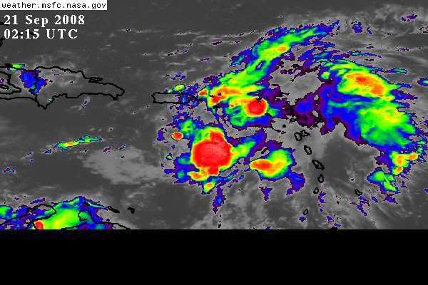
VARIABLY CLOUDY SKIES PREVAILED ACROSS PUERTO RICO...CULEBRA AND VIEQUES
THIS EVENING AS AN AREA OF DISTURBED WEATHER CONTINUED TO MOVE
ACROSS PARTS OF THE LOCAL ISLANDS. WEATHER DOPPLER RADAR DETECTED
SCATTERED TO NUMEROUS SHOWERS AND THUNDERSTORMS ACROSS THE AREA
WATERS AND OVER PARTS OF THE ISLANDS THIS EVENING. WINDS HAVE BEEN
VARIABLY AND GUSTY AT TIMES AS SHOWERS AND THUNDERSTORMS MOVED BY
AFFECTED LOCATIONS.

A BROAD AREA OF DISTURBED WEATHER ASSOCIATED WITH AN ELONGATED AREA
OF LOW PRESSURE CONTINUED THIS EVENING FROM THE EAST CENTRAL
CARIBBEAN SOUTH OF THE MONA PASSAGE...NORTHEASTWARD ACROSS THE
LEEWARD ISLANDS...AND PORTIONS OF THE WINDWARDS. THIS AREA OF
DISTURBED WEATHER IS EXPECTED TO SHIFT SLOWLY NORTH NORTHWESTWARD
ACROSS THE LOCAL AREA THROUGH SUNDAY...AND BRING SCATTERED TO
NUMEROUS SHOWERS AND THUNDERSTORMS...WHICH MAY LEAVE VERY HEAVY
RAINS ACROSS PORTIONS OF THE LOCAL ISLANDS. AHEAD OF THIS
SYSTEM...LOOK FOR FREQUENT PASSING SHOWERS AND ISOLATED
THUNDERSTORMS TO RACE QUICKLY ACROSS THE LOCAL ISLANDS THROUGHOUT
THE OVERNIGHT HOURS...WHICH WILL PRODUCE PERIODS OF BRIEF HEAVY
RAIN AND GUSTY WINDS...ESPECIALLY ACROSS THE AREA WATERS. A
GRADUAL INCREASE IN SHOWER ACTIVITY IS EXPECTED TO BEGIN TO SHIFT
FROM THE OPEN WATERS OF THE NORTHEAST CARIBBEAN...NORTHWESTWARD
AND INTO THE LOCAL AREA BY MIDNIGHT THROUGH SUNDAY MORNING.

THIS AREA OF DISTURBED WEATHER IS FORECAST TO EXIT THE LOCAL AREA
LATE SUNDAY AS IT SHIFTS INTO HISPANIOLA AND THE SOUTHEAST
BAHAMAS. THIS WILL LEAVE IN ITS WAKE A FAIRLY MOIST AND UNSTABLE
WEATHER PATTERN TO PREVAIL ACROSS THE REGION AT LEAST THROUGH THE
MIDDLE OF NEXT WEEK.

A SMALL CRAFT ADVISORY IS IN EFFECT FOR THE LOCAL OFFSHORE
ATLANTIC THROUGH SUNDAY...WHILE SMALL CRAFT SHOULD EXERCISE CAUTION
ELSEWHERE. MARINERS ARE URGED TO REMAIN ALERT FOR OCCASIONAL
SQUALLS AND ISOLATED THUNDERSTORMS PRODUCING WINDS OF 30 KNOTS OR
GREATER.

$$
http://www.srh.noaa.gov/productview.php ... &version=0
0 likes   

User avatar
Blown Away
S2K Supporter
S2K Supporter
Posts: 10145
Joined: Wed May 26, 2004 6:17 am

Re: ATL INVEST 93L: Discussion

#251 Postby Blown Away » Sat Sep 20, 2008 10:18 pm

NCEP Day 6, very close to SFL in the SE Bahamas:
Image

NCEP Day 7, front abruptly turns 93L NE and shows low off Carolinas:
Image
0 likes   

User avatar
MGC
S2K Supporter
S2K Supporter
Posts: 5899
Joined: Sun Mar 23, 2003 9:05 pm
Location: Pass Christian MS, or what is left.

Re: ATL INVEST 93L: Discussion

#252 Postby MGC » Sat Sep 20, 2008 10:24 pm

If it does develope it will have a difficult time with shear and possibly land interaction in the short term. It has been nice with no systems to worry about the past week.....MGC
0 likes   

User avatar
Ptarmigan
Category 5
Category 5
Posts: 5313
Joined: Wed Aug 16, 2006 9:06 pm

Re: ATL INVEST 93L: Discussion

#253 Postby Ptarmigan » Sat Sep 20, 2008 11:52 pm

I think this could be more of a subtropical system once it gets its acts together. Most likely it will be Kyle by next week. We will see.
0 likes   

HurricaneFreak

Re: ATL INVEST 93L: Discussion

#254 Postby HurricaneFreak » Sat Sep 20, 2008 11:56 pm

Hey "Blown_Away" if this storm moves fast then it couldgo really close by Florida but the slower it goes the quicker it will turn towards the northwest then north direction to north east
0 likes   

Weatherfreak000

#255 Postby Weatherfreak000 » Sun Sep 21, 2008 12:06 am

Nice LLC....under Deep Convection?


Instead of wondering when 93L will be Kyle as far as next week...try...36 hours. Finding little reason to believe that won't happen.
0 likes   

User avatar
carolina_73
Tropical Storm
Tropical Storm
Posts: 148
Joined: Wed Jul 23, 2008 1:30 am

Re: ATL INVEST 93L: Discussion

#256 Postby carolina_73 » Sun Sep 21, 2008 3:43 am

ZCZC MIATWOAT ALL
TTAA00 KNHC DDHHMM
TROPICAL WEATHER OUTLOOK
NWS TPC/NATIONAL HURRICANE CENTER MIAMI FL
200 AM EDT SUN SEP 21 2008

FOR THE NORTH ATLANTIC...CARIBBEAN SEA AND THE GULF OF MEXICO...

1. A TROPICAL WAVE...ACCOMPANIED BY A SURFACE LOW PRESSURE SYSTEM OVER
THE NORTHEASTERN CARIBBEAN SEA...IS PRODUCING WIDESPREAD CLOUDINESS
AND SHOWERS OVER THE LESSER ANTILLES...AND ADJACENT CARIBBEAN AND
ATLANTIC WATERS. THIS SYSTEM CONTINUES TO SHOW SIGNS OF
ORGANIZATION...AND UPPER-LEVEL WINDS ARE EXPECTED TO BECOME A
LITTLE MORE FAVORABLE FOR DEVELOPMENT OVER THE NEXT COUPLE OF DAYS.
A TROPICAL DEPRESSION COULD FORM DURING THIS TIME AS THE SYSTEM
MOVES SLOWLY NORTHWESTWARD.
Image
0 likes   

User avatar
caribepr
Category 5
Category 5
Posts: 1794
Joined: Fri Sep 05, 2003 10:43 pm
Location: Culebra, PR 18.33 65.33

#257 Postby caribepr » Sun Sep 21, 2008 3:49 am

Like zygotes splitting...we're in it now, raining hard for the last 45 minutes or so with lightning and thunder that led the way
0 likes   

User avatar
hial2
S2K Supporter
S2K Supporter
Posts: 809
Joined: Fri Oct 10, 2003 9:20 pm
Location: Indian trail N.C.

Re:

#258 Postby hial2 » Sun Sep 21, 2008 4:04 am

caribepr wrote:Like zygotes splitting...we're in it now, raining hard for the last 45 minutes or so with lightning and thunder that led the way


Puerto Rico is the blastocyst in a fallopian tube...... :cheesy:
0 likes   

User avatar
bvigal
S2K Supporter
S2K Supporter
Posts: 2276
Joined: Sun Jul 24, 2005 8:49 am
Location: British Virgin Islands
Contact:

Re: ATL INVEST 93L: Discussion

#259 Postby bvigal » Sun Sep 21, 2008 4:58 am

There is NO reason to skip a model run, because it's obviously not dissipating. This is better organized than it has been in last 48hrs. Wonder WHERE IS THE 6Z MODEL DATA?
Last edited by bvigal on Sun Sep 21, 2008 5:55 am, edited 1 time in total.
0 likes   

xironman
S2K Supporter
S2K Supporter
Posts: 2522
Joined: Sun Jun 10, 2007 4:53 pm
Location: NoVA

Re: ATL INVEST 93L: Discussion

#260 Postby xironman » Sun Sep 21, 2008 5:07 am

Continuous SW winds at the eastern Caribbean buoy http://www.ndbc.noaa.gov/station_page.php?station=42059

Code: Select all

MM    DD    TIME (GMT)   WDIR    WSPD
09   21     0750         SW       7.8
09   21     0650         SSW      5.8
09   21     0550         SSW      5.8
09   21     0450         SSW      5.8
09   21     0350         S        3.9
09   21     0250         SSW      1.9

It will be interesting to see what they find
0 likes   


Return to “2008”

Who is online

Users browsing this forum: No registered users and 5 guests