ATL: IKE Discussion

Moderator: S2k Moderators

Message
Author
User avatar
chris_fit
Category 5
Category 5
Posts: 3242
Age: 42
Joined: Wed Sep 10, 2003 11:58 pm
Location: Tampa Bay Area, FL

Re: ATL IKE: Category 3 - Discussion

#2441 Postby chris_fit » Fri Sep 05, 2008 1:56 pm

Canelaw99 wrote:
jlauderdal wrote:when was the last time they hit it say within 50 miles at 5 days,


Wasn't that about how accurate they were with Gustav??


I think they got pretty lucky with Gustav in the long term, however take a look at their short term forecasts, specifically around Haiti and Isle of Youth, Cuba... 50+ mile difference in 18 hours or less.
0 likes   

tolakram
Admin
Admin
Posts: 20020
Age: 62
Joined: Sun Aug 27, 2006 8:23 pm
Location: Florence, KY (name is Mark)

Re: ATL IKE: Category 3 - Discussion

#2442 Postby tolakram » Fri Sep 05, 2008 1:58 pm

Latest Visible: what kind of color enhancement is this and what does it show us?

Image
0 likes   

mph101
Tropical Low
Tropical Low
Posts: 26
Joined: Sun Sep 30, 2007 1:50 pm
Location: Pinellas Point, Florida

Re: ATL IKE: Category 3 - Discussion

#2443 Postby mph101 » Fri Sep 05, 2008 1:58 pm

NATIONAL WEATHER SERVICE TAMPA BAY RUSKIN FL
130 PM EDT FRI SEP 5 2008


LONG TERM (SUNDAY NIGHT - THURSDAY)...EXACT TRACK AND INTENSITY OF
HURRICANE IKE TO DOMINATE EXTENDED PERIOD. WILL CONTINUE TO CLOSELY
MONITOR OFFICIAL NHC TRACK WITH LATEST FORECAST POSITIONING IKE SE
OF FL MON THEN IN THE FL STRAITS/KEYS AREA TUE THEN INTO THE SE GULF
WED AND SOMEWHERE IN THE E CENTRAL GULF THU. SEE NHC DISCUSSIONS FOR
EXPECTED STEERING PATTERN AND TRACK UNCERTAINTIES. WITH IKE
SOMEWHERE IN THE REGION/AREA EXPECT INCREASE IN
CLOUDS/MOISTURE/WINDS AS EARLY AS MONDAY THEN FURTHER INCREASING
TUE-WED INTO THU. THE CURRENT 5 DAY CONE OF UNCERTAINTY COVERS THE
ENTIRE AREA SO ALL INTERESTS IN SOUTHWEST AND WEST CENTRAL FLORIDA
NEED TO CONTINUE TO CLOSELY MONITOR THE SYSTEM TO SEE HOW THINGS
EVOLVE OVER THE NEXT FEW DAYS.
0 likes   

User avatar
sweetpea
S2K Supporter
S2K Supporter
Posts: 858
Age: 58
Joined: Fri Jun 10, 2005 5:49 pm
Location: Sopchoppy, FL

#2444 Postby sweetpea » Fri Sep 05, 2008 1:58 pm

Governor Crist declares State of Emergency
http://www.palmbeachpost.com/news/conte ... =7&cxcat=0
0 likes   

jinftl
Category 5
Category 5
Posts: 4312
Joined: Tue Aug 31, 2004 4:47 pm
Location: fort lauderdale, fl

Re: ATL IKE: Category 3 - Discussion

#2445 Postby jinftl » Fri Sep 05, 2008 1:59 pm

Technically southeast florida is east of the 5-day forecast point....what we are approaching is more of a 3 or 4-day forecast at this point. The cone starts to shrink as the time to landfall grows closer and accuracy margin improves.

This is probably going to be a tuesday event, possible starting as early as late Monday. The 5-day forecast point is Wednesday pm as of the next advisory. Most indications are this will be west of southeast florida by then.

superfly wrote:
jlauderdal wrote:yes they have but being at there 5 day point really isnt such a bad place to be, i guess i would rather be there than at a point say 150 miles on either side, when was the last time they hit it say within 50 miles at 5 days


Image
0 likes   

User avatar
KWT
Category 5
Category 5
Posts: 31415
Joined: Tue Aug 17, 2004 11:02 am
Location: UK!!!

#2446 Postby KWT » Fri Sep 05, 2008 2:00 pm

The key is what happens after the WSW motion?
The GFS slowly breaks down the ridge and allows the system to start gaining some latitude but the ECM shows no weakness at all and shoots it up the spine of Cuba westwards.

I'm not all that sure what will happen myself, quite possibly something down the middle?

I think a state of emergency is probably the wisest thing to do right now for those in powers.
0 likes   

jlauderdal
S2K Supporter
S2K Supporter
Posts: 7188
Joined: Wed May 19, 2004 5:46 am
Location: NE Fort Lauderdale
Contact:

Re: ATL IKE: Category 3 - Discussion

#2447 Postby jlauderdal » Fri Sep 05, 2008 2:02 pm

chris_fit wrote:
Canelaw99 wrote:
jlauderdal wrote:when was the last time they hit it say within 50 miles at 5 days,


Wasn't that about how accurate they were with Gustav??


I think they got pretty lucky with Gustav in the long term, however take a look at their short term forecasts, specifically around Haiti and Isle of Youth, Cuba... 50+ mile difference in 18 hours or less.


hmm, i never thought about that but you are right, ok im changing my stance, i want to be at the 24 hour point, LOL
0 likes   

jlauderdal
S2K Supporter
S2K Supporter
Posts: 7188
Joined: Wed May 19, 2004 5:46 am
Location: NE Fort Lauderdale
Contact:

Re:

#2448 Postby jlauderdal » Fri Sep 05, 2008 2:03 pm

sweetpea wrote:Governor Crist declares State of Emergency
http://www.palmbeachpost.com/news/conte ... =7&cxcat=0


he already declared a state of emergency for hanna isn't that still in effect, you know its active when you are under two states of emergency
0 likes   

User avatar
sweetpea
S2K Supporter
S2K Supporter
Posts: 858
Age: 58
Joined: Fri Jun 10, 2005 5:49 pm
Location: Sopchoppy, FL

Re: Re:

#2449 Postby sweetpea » Fri Sep 05, 2008 2:04 pm

jlauderdal wrote:
sweetpea wrote:Governor Crist declares State of Emergency
http://www.palmbeachpost.com/news/conte ... =7&cxcat=0


he already declared a state of emergency for hanna isn't that still in effect, you know its active when you are under two states of emergency

This one is for Ike. I don't know if it just adds on to Hannah's? This one is for the ENTIRE state!! :double:
0 likes   

SapphireSea
Category 1
Category 1
Posts: 430
Joined: Wed Aug 24, 2005 12:13 pm
Location: Miami, FL

Re: ATL IKE: Category 3 - Discussion

#2450 Postby SapphireSea » Fri Sep 05, 2008 2:06 pm

tolakram wrote:Latest Visible: what kind of color enhancement is this and what does it show us?

Image


That would be a rainbow/white spectrum IR shot. I believe he is trying to expand circulation Northward but shear is doing an excellent job of limiting organization. Looks to be moving about West (270) right now as well.
0 likes   

TheShrimper
Category 2
Category 2
Posts: 516
Joined: Sun Aug 01, 2004 5:05 pm

Re: ATL IKE: Category 3 - Discussion

#2451 Postby TheShrimper » Fri Sep 05, 2008 2:10 pm

Crist had a press conference at 11 AM stating that there is still a state of emergency. He kind of covered his a--, with a transition from Hanna (premature) to Ike as far as the concern. Nothing was stated other than the obvious......I think him and Nagin are battling for the attention.
0 likes   

User avatar
VeniceInlet
Tropical Depression
Tropical Depression
Posts: 92
Joined: Sun Jun 11, 2006 10:12 pm
Location: Nokomis, FL

Re: ATL IKE: Category 3 - Discussion

#2452 Postby VeniceInlet » Fri Sep 05, 2008 2:12 pm

Someone correct me if I'm wrong, but with Gustav, weren't the models pretty much in consensus five days out? I'd say that in cases like that, the chances of being right are better than if the models are all over the map in five days. Every storm situation is different and when there are more variables and uncertainties that come into play, then the less likely the five day will be on the money. At least that seems more common sense to me. In its advisories, when there are uncertainties, the NHC mentions them if there are any and says that the track could vary. I don't know, the more messed up the models look, the less I have confidence in the five-day. That may be unscientific but it seems to bear out.
Last edited by VeniceInlet on Fri Sep 05, 2008 2:15 pm, edited 1 time in total.
0 likes   

jinftl
Category 5
Category 5
Posts: 4312
Joined: Tue Aug 31, 2004 4:47 pm
Location: fort lauderdale, fl

Re: ATL IKE: Category 3 - Discussion

#2453 Postby jinftl » Fri Sep 05, 2008 2:13 pm

I think when it comes to whether to take a threat seriously, and in turn, prepare properly when needed, should be based on:

1. What is the official NHC forecast. If you are in the cone, you are threatened. If you are in a watch or warning, assume if it is coming towards you. The NHC has proven themselves time and again and to second guess whether their cone or track or strength estimate is absurd.

2. Listen to governement and local officials....they are not going to steer you wrong.

3. Don't make decisions that effect you outside of this message board based on the black line of the forecast. We can squabble over that here...but prepare based on the cone. Assume the storm will be somewhere in the cone moving out in time as the NHC shows.

4. A storm is more than its eye....if tropical storm force winds extend 100 miles on all sides, guess what.....pretty much the entire cone in the 72-96 hour range is going to see at least tropical storm condiions.
0 likes   

Scorpion

#2454 Postby Scorpion » Fri Sep 05, 2008 2:15 pm

What's up with the 954 pressure and 79 kt wind? Error?
0 likes   

CrazyC83
Professional-Met
Professional-Met
Posts: 34005
Joined: Tue Mar 07, 2006 11:57 pm
Location: Deep South, for the first time!

Re:

#2455 Postby CrazyC83 » Fri Sep 05, 2008 2:16 pm

Scorpion wrote:What's up with the 954 pressure and 79 kt wind? Error?


Not sure, since that would translate down to 947mb if confirmed at the surface. I am sure the VDM will show something higher.
0 likes   

User avatar
Canelaw99
S2K Supporter
S2K Supporter
Posts: 2128
Age: 48
Joined: Tue Aug 31, 2004 8:27 am
Location: Homestead, FL

Re: ATL IKE: Category 3 - Discussion

#2456 Postby Canelaw99 » Fri Sep 05, 2008 2:16 pm

From Broward EOC -

Mayor - We have the weekend to prepare, so please use it. Be prepared for the first 72 hours. This includes food, water, medications, etc. Have an evacuation plan if you live in an evacuation zone. Now is the time to assess your home. Go outside. Check your roof, landscaping, pool area, windows, garage. Assess your personal important documents. Take pictures of what is of value both inside and outside your home. If you're fortunate enough to have a video camera, use it. If you have patio furniture, or other unsecured items outside, now is the time to bring them inside. Now is the time to be a good neighbor and make sure you don't have something that will become flying objects. We encourage you to have flashlights, batteries, and ice on hand. Fill up your gas tanks. Be sure you have cash on hand. If the storm continues to move on the course it's moving, Monday is the day we'd begin to see a "little bit" of wind activity. Be sure to have your cell phones charged. Make plans for your pets. They will have a pet friendly shelter at Milennium school in Tamarac (pre-reg. required). 311 hotline open Sunday morning and will have staff there 24/7 to answer questions.

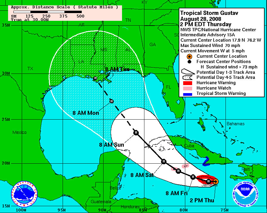
This is not the time to panic. This is the time to prepare. This is not an exercise. This storm could have catastrophic impact on this area. This is a storm that is providing a huge potential impact. Do not follow that line as it can change every 6 hours.

Take this storm seriously. Use common sense. Stay tuned to local media for latest info. We are here and monitoring this storm.

http://www.broward.org has a lot of good hurricane info.
0 likes   

User avatar
cycloneye
Admin
Admin
Posts: 145867
Age: 69
Joined: Thu Oct 10, 2002 10:54 am
Location: San Juan, Puerto Rico

Re: ATL: IKE Recon Discussion

#2457 Postby cycloneye » Fri Sep 05, 2008 2:18 pm

Pressure lower at second pass,954 mbs from 959 at first one.

93 kt FL, 87 kt SFMR, pressure 954mb.
0 likes   

User avatar
KWT
Category 5
Category 5
Posts: 31415
Joined: Tue Aug 17, 2004 11:02 am
Location: UK!!!

#2458 Postby KWT » Fri Sep 05, 2008 2:18 pm

Well the convection in Ike's eyewalls is bursting and is now covering the eye to some degree, sort of like a slightly better organised Gustav...

Oh yeah and here is what the HPC thinks will happen, this is not something Ivanhater will take pleasure seeing:

http://img390.imageshack.us/my.php?imag ... ntsvw2.jpg

Its amazing to think we may have another major hurricane threatening land so soon after Gustav.
0 likes   

User avatar
HURAKAN
Professional-Met
Professional-Met
Posts: 46086
Age: 38
Joined: Thu May 20, 2004 4:34 pm
Location: Key West, FL
Contact:

#2459 Postby HURAKAN » Fri Sep 05, 2008 2:20 pm

Image
0 likes   

User avatar
Sabanic
Category 2
Category 2
Posts: 683
Age: 65
Joined: Wed Aug 01, 2007 7:01 am
Location: Mobile, AL
Contact:

Re:

#2460 Postby Sabanic » Fri Sep 05, 2008 2:20 pm

KWT wrote:Well the convection in Ike's eyewalls is bursting and is now covering the eye to some degree, sort of like a slightly better organised Gustav...

Oh yeah and here is what the HPC thinks will happen, this is not something Ivanhater will take pleasure seeing:

http://img390.imageshack.us/my.php?imag ... ntsvw2.jpg


Nor will his neighbors on either side
0 likes   


Return to “2008”

Who is online

Users browsing this forum: No registered users and 5 guests