ATL: Invest 97L in Central Atlantic
Moderator: S2k Moderators
-
wzrgirl1

- S2K Supporter

- Posts: 1360
- Joined: Sat Sep 04, 2004 6:44 am
- Location: Pembroke Pines, Florida
Re: ATL: Invest 97L in Central Atlantic
gatorcane wrote:wzrgirl1 wrote:what do you all think about the loop scenario I suggested above?
A loop could happen if a system gets pulled N by a weakness (e.g. from a short-wave trough) but the trough does not completely catch the system and a ridge builds in from the NW behind the trough pushing the system west again.
I see no evidence of such a situation with 97L and even so its so long out (like 7-10 days) and so many IFs (like will 97L even develop) that I haven't thought much about it. Are you seeing something with the long-range synoptics that may suggest a loop?
Actually gator I haven't really seen anything....only looking at the models and towards the end of the runs it seems as if they are in the beginnings of a possible loop, but I haven't studied the environment in the long range as of yet....
http://www.wunderground.com/tropical/tr ... model.html
0 likes

-
cycloneye

- Admin

- Posts: 149275
- Age: 69
- Joined: Thu Oct 10, 2002 10:54 am
- Location: San Juan, Puerto Rico
Re: ATL: Invest 97L in Central Atlantic
The latest ATCF Best Track at 18:00 UTC:
AL, 97, 2008072518, , BEST, 0, 183N, 422W, 25, 1010, DB, 34, NEQ, 0, 0, 0, 0, 1012, 120, 25, 0, 0,
AL, 97, 2008072518, , BEST, 0, 183N, 422W, 25, 1010, DB, 34, NEQ, 0, 0, 0, 0, 1012, 120, 25, 0, 0,
0 likes


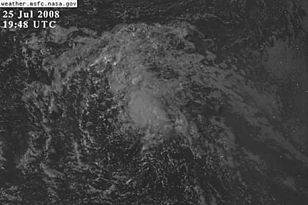
Re: ATL: Invest 97L in Central Atlantic
Obviously not much coverage but it looks like there's inflow from everywhere, if those are low clouds.
0 likes
-
gatorcane

- S2K Supporter
- Posts: 23708
- Age: 48
- Joined: Sun Mar 13, 2005 3:54 pm
- Location: Boca Raton, FL
Re: ATL: Invest 97L in Central Atlantic
Personal Forecast Disclaimer:
The posts in this forum are NOT official forecast and should not be used as such. They are just the opinion of the poster and may or may not be backed by sound meteorological data. They are NOT endorsed by any professional institution or storm2k.org. For official information, please refer to the NHC and NWS products.
Here is a good loop for members to look at as to why the forecast reasoning is for a recurve:
http://www.ssd.noaa.gov/goes/east/natl/loop-wv.html
Check out the deep trough digging down at around 50W as a powerful Northern Atlantic Low spinning on the top of the screen is pushing south. That should be enough to deflect 97L out to sea ultimately.
There is also a stationary ULL low parked just SSE of Bermuda also. Even if 97L were to head more W it would be running into hostile Upper-Level winds.
I expect 97L to slide inbetween the ULL and the trough digging south and bend NNW around 50-55W again well NE of the Leewards and out of harms way.
0 likes


Re: ATL: Invest 97L in Central Atlantic
cycloneye wrote::uarrow: I see a circulation at 17.8n-42.5w.
I think you see a smaller circulation to north of the one I saw earlier at 14.5N. They both actually seem to be rotating around broader center in between. Still a disorganzied system.
0 likes
-
Ed Mahmoud
Re: ATL: Invest 97L in Central Atlantic
Double Post Alert:
This wave seems to extend all the way to the ITCZ, with an enhancement of activity just South of 10ºN
The most prominent apparent circulation closer to 18ºN seems part of a looser elliptical circulation extending SSW from the 18º circulation that seems to suggest fairly low level West winds down to about 13ºN, with a lesser maximum, or "pole", of the elliptical circulation near 15ºN, 44ºW.
The more convectively active part of the circulation could break off and try to develop, leaving the Southern end of the wave to continue on a more Westward path.
Perhaps the models are picking up on that with a fairly quick recurve of the partially exposed circulation closer to the convection.
The 12Z GFS quickly develops the Northernmost vorticity, and pulls the Southernmost 850 mb vort max into it, but notice it initializes the Southern vort max stronger.

I'm not convinced the 18ºN will overcome dry air and shear to develop. However, if it does, I'm not sure part of the wave won't continue Westward, and may become active in the Caribbean or Pacific.
This wave seems to extend all the way to the ITCZ, with an enhancement of activity just South of 10ºN
The most prominent apparent circulation closer to 18ºN seems part of a looser elliptical circulation extending SSW from the 18º circulation that seems to suggest fairly low level West winds down to about 13ºN, with a lesser maximum, or "pole", of the elliptical circulation near 15ºN, 44ºW.
The more convectively active part of the circulation could break off and try to develop, leaving the Southern end of the wave to continue on a more Westward path.
Perhaps the models are picking up on that with a fairly quick recurve of the partially exposed circulation closer to the convection.
The 12Z GFS quickly develops the Northernmost vorticity, and pulls the Southernmost 850 mb vort max into it, but notice it initializes the Southern vort max stronger.
I'm not convinced the 18ºN will overcome dry air and shear to develop. However, if it does, I'm not sure part of the wave won't continue Westward, and may become active in the Caribbean or Pacific.
0 likes
-
gatorcane
- S2K Supporter
- Posts: 23708
- Age: 48
- Joined: Sun Mar 13, 2005 3:54 pm
- Location: Boca Raton, FL
Re: ATL: Invest 97L in Central Atlantic
looks like the "LLC" at 17.9N is moving due west at the moment while the convection is getting sheared off to the NE. That may give an appearance it is moving WNW already when indeed the swirl continues moving west.
http://www.ssd.noaa.gov/goes/east/tatl/loop-vis.html
http://www.ssd.noaa.gov/goes/east/tatl/loop-vis.html
0 likes


-
GeneratorPower

- S2K Supporter
- Posts: 1648
- Age: 46
- Joined: Sun Dec 18, 2005 11:48 pm
- Location: Huntsville, AL
-
fasterdisaster
- Category 5

- Posts: 1868
- Joined: Mon Sep 19, 2005 4:41 pm
- Location: Miami, Florida
Who is online
Users browsing this forum: No registered users and 30 guests