ATL OMAR: Remnant Low - Discussion

Moderator: S2k Moderators

Message
Author
User avatar
HURAKAN
Professional-Met
Professional-Met
Posts: 46086
Age: 38
Joined: Thu May 20, 2004 4:34 pm
Location: Key West, FL
Contact:

#361 Postby HURAKAN » Tue Oct 14, 2008 8:16 pm

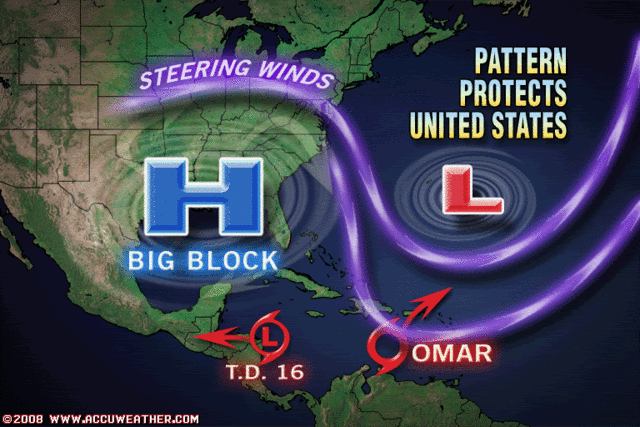
Image

From Accuweather.
0 likes   

HurricaneHunter914
Category 5
Category 5
Posts: 4439
Age: 31
Joined: Fri Mar 10, 2006 7:36 pm
Location: College Station, TX

#362 Postby HurricaneHunter914 » Tue Oct 14, 2008 8:20 pm

I hope that's not a pinhole eye showing up in the center. :eek:

Image

http://www.ssd.noaa.gov/goes/flt/t2/avn-l.jpg
0 likes   

User avatar
Just Joshing You
Category 2
Category 2
Posts: 512
Joined: Sat Nov 03, 2007 10:29 am
Location: Nova Scotia

#363 Postby Just Joshing You » Tue Oct 14, 2008 8:22 pm

I hope not.
0 likes   

User avatar
HURAKAN
Professional-Met
Professional-Met
Posts: 46086
Age: 38
Joined: Thu May 20, 2004 4:34 pm
Location: Key West, FL
Contact:

#364 Postby HURAKAN » Tue Oct 14, 2008 8:23 pm

HH914, That's very likely a towering cumulus.
0 likes   

Driftin
Tropical Low
Tropical Low
Posts: 20
Joined: Mon Jun 16, 2008 8:40 am
Location: Borinken

Re:

#365 Postby Driftin » Tue Oct 14, 2008 8:24 pm

Just Joshing You wrote:I hope not.


forgive my ignorance but
why is that bad?
0 likes   

User avatar
HURAKAN
Professional-Met
Professional-Met
Posts: 46086
Age: 38
Joined: Thu May 20, 2004 4:34 pm
Location: Key West, FL
Contact:

Re: Re:

#366 Postby HURAKAN » Tue Oct 14, 2008 8:26 pm

Driftin wrote:
Just Joshing You wrote:I hope not.


forgive my ignorance but
why is that bad?


Small eye usually means rapid intensification.
0 likes   

CrazyC83
Professional-Met
Professional-Met
Posts: 34002
Joined: Tue Mar 07, 2006 11:57 pm
Location: Deep South, for the first time!

#367 Postby CrazyC83 » Tue Oct 14, 2008 8:28 pm

Microwave suggests it is INDEED a pinhole eye.
0 likes   

User avatar
Just Joshing You
Category 2
Category 2
Posts: 512
Joined: Sat Nov 03, 2007 10:29 am
Location: Nova Scotia

#368 Postby Just Joshing You » Tue Oct 14, 2008 8:32 pm

That picture on page 18 is too dark.. post a better :P
0 likes   

User avatar
HURAKAN
Professional-Met
Professional-Met
Posts: 46086
Age: 38
Joined: Thu May 20, 2004 4:34 pm
Location: Key West, FL
Contact:

#369 Postby HURAKAN » Tue Oct 14, 2008 8:38 pm

Image
0 likes   

User avatar
RattleMan
Category 5
Category 5
Posts: 1218
Joined: Wed Aug 24, 2005 7:14 pm
Location: Phoenix, AZ

Re: ATL OMAR: Tropical Storm - Discussion

#370 Postby RattleMan » Tue Oct 14, 2008 8:40 pm

AL, 15, 2008101500, , BEST, 0, 141N, 683W, 65, 979, HU, 34, NEQ, 60, 80, 40, 20, 1008, 180, 15, 0, 0, L, 0, , 0, 0, OMAR, D,
AL, 15, 2008101500, , BEST, 0, 141N, 683W, 65, 979, HU, 50, NEQ, 30, 40, 20, 0, 1008, 180, 15, 0, 0, L, 0, , 0, 0, OMAR, D,
AL, 15, 2008101500, , BEST, 0, 141N, 683W, 65, 979, HU, 64, NEQ, 15, 15, 0, 0, 1008, 180, 15, 0, 0, L, 0, , 0, 0, OMAR, D,
0 likes   
User avatar
HURAKAN
Professional-Met
Professional-Met
Posts: 46086
Age: 38
Joined: Thu May 20, 2004 4:34 pm
Location: Key West, FL
Contact:

#371 Postby HURAKAN » Tue Oct 14, 2008 8:46 pm

Image
0 likes   

User avatar
dixiebreeze
S2K Supporter
S2K Supporter
Posts: 5140
Joined: Wed Sep 03, 2003 5:07 pm
Location: crystal river, fla.

Re: ATL OMAR: Tropical Storm - Discussion

#372 Postby dixiebreeze » Tue Oct 14, 2008 8:50 pm

0 likes   

tolakram
Admin
Admin
Posts: 20009
Age: 62
Joined: Sun Aug 27, 2006 8:23 pm
Location: Florence, KY (name is Mark)

Re: ATL OMAR: Tropical Storm - Discussion

#373 Postby tolakram » Tue Oct 14, 2008 8:56 pm

I'm not seeing the pinhole eye.

edit: Well since I posted the imaes have updated and it looks a little more ominous. :(

Image

Image
Last edited by tolakram on Tue Oct 14, 2008 9:00 pm, edited 1 time in total.
0 likes   

User avatar
Just Joshing You
Category 2
Category 2
Posts: 512
Joined: Sat Nov 03, 2007 10:29 am
Location: Nova Scotia

#374 Postby Just Joshing You » Tue Oct 14, 2008 8:57 pm

I'm pretty sure it isn't a pinhole eye.
0 likes   

tolakram
Admin
Admin
Posts: 20009
Age: 62
Joined: Sun Aug 27, 2006 8:23 pm
Location: Florence, KY (name is Mark)

Re: ATL OMAR: Tropical Storm - Discussion

#375 Postby tolakram » Tue Oct 14, 2008 8:58 pm

Well since I posted the imaes have updated and it looks a little more ominous. :(
0 likes   

MiamiensisWx

#376 Postby MiamiensisWx » Tue Oct 14, 2008 9:10 pm

If Omar is upgraded to a hurricane in the 11 p.m. package, it will establish a new record (15 hours) for the fastest intensification from a TD to a hurricane within 24 hours. The current record holder is Humberto 2007, which deepened from a TD to a hurricane within 19 hours, respectively.

I'm incredulous and astounded (and concerned)...
Last edited by MiamiensisWx on Tue Oct 14, 2008 9:13 pm, edited 3 times in total.
0 likes   

RL3AO
Moderator-Pro Met
Moderator-Pro Met
Posts: 16308
Joined: Thu Jun 14, 2007 10:03 pm
Location: NC

#377 Postby RL3AO » Tue Oct 14, 2008 9:10 pm

Theres an eyewall developing. Not sure if I'd call it a pinhole.
0 likes   

User avatar
HURAKAN
Professional-Met
Professional-Met
Posts: 46086
Age: 38
Joined: Thu May 20, 2004 4:34 pm
Location: Key West, FL
Contact:

#378 Postby HURAKAN » Tue Oct 14, 2008 9:33 pm

Image

Omar is not stopping.
0 likes   

Ed Mahmoud

Re: ATL OMAR: Tropical Storm - Discussion

#379 Postby Ed Mahmoud » Tue Oct 14, 2008 9:41 pm

Don't normally see widespread sub -80ºC tops in an Atlantic cyclone.

I'll be asleep, but I wouldn't be surprised if the early morning recon finds Omar approaching major hurricane status.
0 likes   

Sanibel
Category 5
Category 5
Posts: 10375
Joined: Mon Aug 30, 2004 11:06 pm
Location: Offshore SW Florida

Re: ATL OMAR: Tropical Storm - Discussion

#380 Postby Sanibel » Tue Oct 14, 2008 9:47 pm

Last ugly black IR I saw like that in the Caribbean was Wilma.

Look out St Croix!
0 likes   


Return to “2008”

Who is online

Users browsing this forum: No registered users and 7 guests