BatzVI wrote:Thanks....is that because of the upper level steering? Trying to learn....
If it stays weak, then the easterly flow will dominate. If it intensifies, then we get into the upper level steering.
Moderator: S2k Moderators


BatzVI wrote:Thanks....is that because of the upper level steering? Trying to learn....


bvigal wrote:680
WHXX01 KWBC 101254
CHGHUR
TROPICAL CYCLONE GUIDANCE MESSAGE
NWS TPC/NATIONAL HURRICANE CENTER MIAMI FL
1254 UTC SUN AUG 10 2008
DISCLAIMER...NUMERICAL MODELS ARE SUBJECT TO LARGE ERRORS.
PLEASE REFER TO NHC OFFICIAL FORECASTS FOR TROPICAL CYCLONE
AND SUBTROPICAL CYCLONE INFORMATION.
ATLANTIC OBJECTIVE AIDS FOR
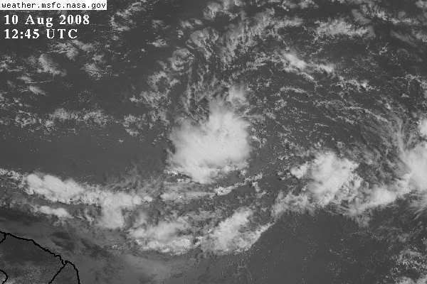
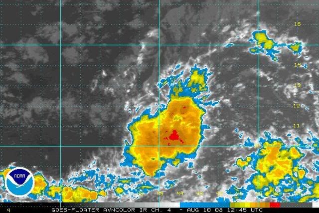
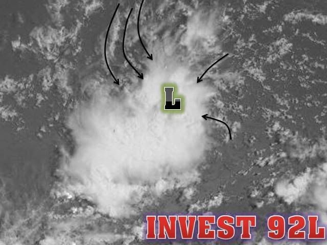
DISTURBANCE INVEST (AL922008) 20080810 1200 UTC
...00 HRS... ...12 HRS... ...24 HRS. .. ...36 HRS...
080810 1200 080811 0000 080811 1200 080812 0000
LAT LON LAT LON LAT LON LAT LON
BAMS 10.5N 43.0W 11.5N 44.3W 12.3N 45.8W 12.9N 47.3W
BAMD 10.5N 43.0W 11.1N 45.0W 11.6N 47.0W 12.0N 48.9W
BAMM 10.5N 43.0W 11.1N 44.9W 11.8N 46.6W 12.4N 48.0W
LBAR 10.5N 43.0W 10.9N 45.6W 11.6N 48.2W 12.3N 50.9W
SHIP 25KTS 30KTS 36KTS 45KTS
DSHP 25KTS 30KTS 36KTS 45KTS
...48 HRS... ...72 HRS... ...96 HRS. .. ..120 HRS...
080812 1200 080813 1200 080814 1200 080815 1200
LAT LON LAT LON LAT LON LAT LON
BAMS 13.6N 49.6W 16.0N 55.0W 18.8N 61.6W 21.2N 68.2W
BAMD 12.5N 50.9W 14.5N 55.6W 16.2N 61.0W 17.2N 66.8W
BAMM 13.0N 49.9W 14.9N 54.8W 16.7N 60.4W 17.8N 66.5W
LBAR 13.1N 53.6W 15.1N 58.6W 17.1N 63.8W 19.3N 68.7W
SHIP 55KTS 71KTS 81KTS 84KTS
DSHP 55KTS 71KTS 81KTS 84KTS
...INITIAL CONDITIONS...
LATCUR = 10.5N LONCUR = 43.0W DIRCUR = 270DEG SPDCUR = 16KT
LATM12 = 10.5N LONM12 = 39.7W DIRM12 = 270DEG SPDM12 = 16KT
LATM24 = 10.5N LONM24 = 36.4W
WNDCUR = 25KT RMAXWD = 0NM WNDM12 = 25KT
CENPRS = 1009MB OUTPRS = 1011MB OUTRAD = 150NM SDEPTH = M
RD34NE = 0NM RD34SE = 0NM RD34SW = 0NM RD34NW = 0NM
$$
NNNN
katdaddy i'm surprised that the houston/galveston nws is even commenting on this system so early, but right now i'm not totally convinced that the nw or western gom should be ruled out.KatDaddy wrote:Currently the good news for the W and NW GOM is the forcasted troughs over the E US during the upcoming week.
This will keep us protected from tropical cyclone moving into the Caribbean. However the E GOM up through the E Seaboard may have some threats down the road.
Houston-Galveston AFD Excerpt:
LASTLY...THE TROPICS LOOK TO BE GETTING MORE ACTIVE. BOTH THE GFS
AND ECMWF ARE IN GOOD AGREEMENT WITH A SYSTEM APPROACHING FL/CUBA
BY AUGUST 19TH. CONDITIONS LOOK FAVORABLE FOR THE SYSTEM TO
DEVELOP. 500 MB FLOW SHOWS A BREAK IN THE RIDGE AND A WEAK TROUGH
MOVING ACROSS THE OHIO VALLEY. AT THIS TIME...THE SYSTEM LOOKS
LIKE IT`LL TURN TO THE NORTH OVER THE EASTERN GULF. BEARS WATCH.
KatDaddy wrote:
Houston-Galveston AFD Excerpt:
LASTLY...THE TROPICS LOOK TO BE GETTING MORE ACTIVE. BOTH THE GFS
AND ECMWF ARE IN GOOD AGREEMENT WITH A SYSTEM APPROACHING FL/CUBA
BY AUGUST 19TH. CONDITIONS LOOK FAVORABLE FOR THE SYSTEM TO
DEVELOP. 500 MB FLOW SHOWS A BREAK IN THE RIDGE AND A WEAK TROUGH
MOVING ACROSS THE OHIO VALLEY. AT THIS TIME...THE SYSTEM LOOKS
LIKE IT`LL TURN TO THE NORTH OVER THE EASTERN GULF. BEARS WATCH.

hawkeh wrote:How about we worry about the islands first, sheesh
Users browsing this forum: Google Adsense [Bot] and 35 guests