ATL: Marco : Tropical Depression - Discussion

Moderator: S2k Moderators

Message
Author
User avatar
HURAKAN
Professional-Met
Professional-Met
Posts: 46086
Age: 37
Joined: Thu May 20, 2004 4:34 pm
Location: Key West, FL
Contact:

#41 Postby HURAKAN » Mon Oct 06, 2008 5:14 am

Image

Image
0 likes   

User avatar
HURAKAN
Professional-Met
Professional-Met
Posts: 46086
Age: 37
Joined: Thu May 20, 2004 4:34 pm
Location: Key West, FL
Contact:

Re: ATL: INVEST 96L - Discussion

#42 Postby HURAKAN » Mon Oct 06, 2008 5:24 am

TROPICAL WEATHER DISCUSSION
NWS TPC/NATIONAL HURRICANE CENTER MIAMI FL
805 AM EDT MON OCT 06 2008

...DISCUSSION...

GULF OF MEXICO...
BROAD UPPER RIDGE IS ANCHORED ALONG THE COAST OF NE YUCATAN
PENINSULA COVERING ALL OF THE GULF WATERS BRINGING MOIST
TROPICAL AIR ACROSS MOST OF THE GULF S OF A LINE FROM NE FLORIDA
NEAR 30N83W TO MEXICO JUST S OF MATAMOROS. A 1010 MB LOW REMAINS
ALONG THE COAST OF S MEXICO IN THE BAY OF CAMPECHE JUST W OF
CIUDAD DEL CARMEN WITH A SURFACE TROUGH EXTENDING N INTO THE
GULF OF MEXICO ALONG 24N90W TO NEAR 27N86W...THIS MAY STILL
BECOME A SPECIAL FEATURE OVER THE NEXT FEW HOURS IF IT MOVES
INTO THE BAY OF CAMPECHE. HEAVY SHOWERS/THUNDERSTORMS ARE
ASSOCIATED WITH THIS FEATURE S OF 19N TO INLAND OVER MEXICO
BETWEEN 92W-94W WITH SCATTERED SHOWERS/ISOLATED THUNDERSTORMS S
OF 21N BETWEEN 91W-95W.
SIMILAR ACTIVITY IS OVER THE E GULF FROM
25N-30N E OF 90W ACROSS THE FLORIDA PENINSULA. ISOLATED SHOWERS
ARE CONTINUE TO MOVING THROUGH THE FLORIDA STRAITS S OF 25N E OF
86W. A WEAK SURFACE RIDGE REMAINS OVER THE NE GULF WITH THE NEXT
FRONTAL BOUNDARY EXPECTED TO ENTER THE GULF LATE TUE.
0 likes   

superfly
Category 4
Category 4
Posts: 938
Joined: Wed Aug 03, 2005 2:13 pm
Location: New Orleans, LA

#43 Postby superfly » Mon Oct 06, 2008 6:32 am

Looks like it's over water now and has a good shot at becoming a TD by 5 PM.
0 likes   

User avatar
HURAKAN
Professional-Met
Professional-Met
Posts: 46086
Age: 37
Joined: Thu May 20, 2004 4:34 pm
Location: Key West, FL
Contact:

#44 Postby HURAKAN » Mon Oct 06, 2008 6:56 am

Tropical Weather Outlook


Statement as of 8:00 am EDT on October 6, 2008

For the North Atlantic...Caribbean Sea and the Gulf of Mexico...

:rarrow: 
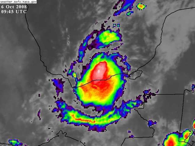
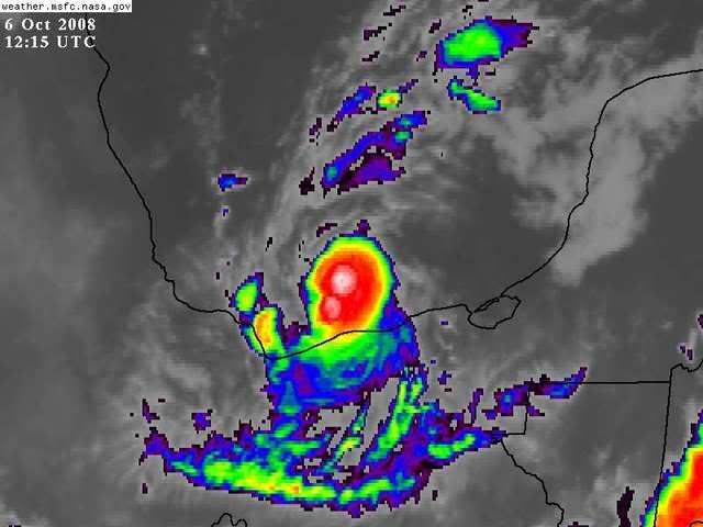
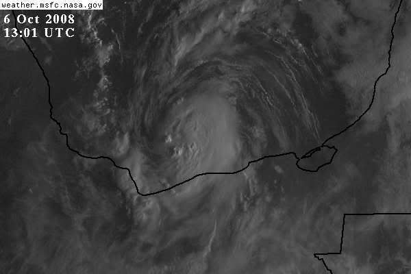
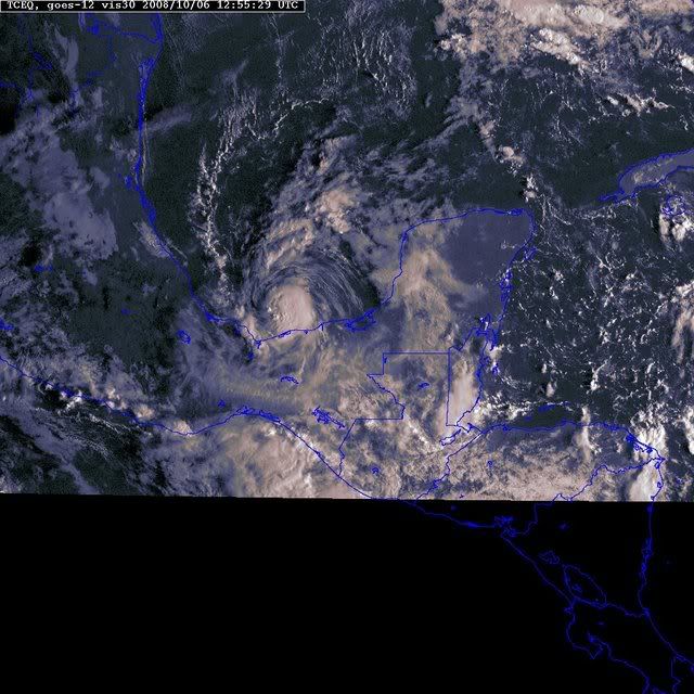
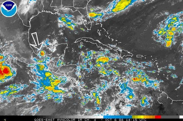
Showers and thunderstorms over the southern Bay of Campeche are
associated with a small low pressure area. The low is forecast to
continue westward during the next 12 to 24 hours and some
development is possible before it moves inland over Mainland Mexico
tonight or Tuesday. Regardless of development...locally heavy
rains and the potential for flash floods and mudslides are possible
over coastal regions of southern Mexico near the the Bay of
Campeche. These conditions could spread westward over the next day
or two.

An area of low pressure has developed over the far eastern Atlantic
about 400 miles southwest of the Cape Verde Islands. Significant
development of this system is not expected due to unfavorable
upper-level winds.

Elsewhere...tropical cyclone formation is not expected during the
next 48 hours.

$$

Forecaster Rhome
0 likes   

User avatar
HURAKAN
Professional-Met
Professional-Met
Posts: 46086
Age: 37
Joined: Thu May 20, 2004 4:34 pm
Location: Key West, FL
Contact:

#45 Postby HURAKAN » Mon Oct 06, 2008 7:53 am

Image

If this develops, it will probably be the smallest ever in the Atlantic. Wow.
0 likes   

User avatar
tailgater
S2K Supporter
S2K Supporter
Posts: 3339
Joined: Sun Jul 11, 2004 9:13 pm
Location: St. Amant La.

Re: ATL: INVEST 96L - Discussion

#46 Postby tailgater » Mon Oct 06, 2008 8:00 am

If this develops, it will probably be the smallest ever in the Atlantic. Wow
Take a look at the visible it's almost cute.
http://weather.msfc.nasa.gov/GOES/GOES1 ... YrQFdW.jpg
0 likes   

User avatar
HURAKAN
Professional-Met
Professional-Met
Posts: 46086
Age: 37
Joined: Thu May 20, 2004 4:34 pm
Location: Key West, FL
Contact:

#47 Postby HURAKAN » Mon Oct 06, 2008 8:12 am

Image

It looks like a TC.
0 likes   

User avatar
HURAKAN
Professional-Met
Professional-Met
Posts: 46086
Age: 37
Joined: Thu May 20, 2004 4:34 pm
Location: Key West, FL
Contact:

#48 Postby HURAKAN » Mon Oct 06, 2008 8:15 am

06/1145 UTC 18.9N 93.7W T1.0/1.0 96L
0 likes   

User avatar
DESTRUCTION5
Category 5
Category 5
Posts: 4391
Age: 42
Joined: Wed Sep 03, 2003 11:25 am
Location: Stuart, FL

#49 Postby DESTRUCTION5 » Mon Oct 06, 2008 8:21 am

Wow...What tiny little sucker...If it gets named it gets the Midget award for the year for sure..
0 likes   

User avatar
HURAKAN
Professional-Met
Professional-Met
Posts: 46086
Age: 37
Joined: Thu May 20, 2004 4:34 pm
Location: Key West, FL
Contact:

#50 Postby HURAKAN » Mon Oct 06, 2008 8:47 am

Image
0 likes   

User avatar
Just Joshing You
Category 2
Category 2
Posts: 512
Joined: Sat Nov 03, 2007 10:29 am
Location: Nova Scotia

#51 Postby Just Joshing You » Mon Oct 06, 2008 8:59 am

Tracy, meet Marco. Marco, meet Tracy.
0 likes   

User avatar
HURAKAN
Professional-Met
Professional-Met
Posts: 46086
Age: 37
Joined: Thu May 20, 2004 4:34 pm
Location: Key West, FL
Contact:

#52 Postby HURAKAN » Mon Oct 06, 2008 9:17 am

invest_RENUMBER_al962008_al132008.ren

AL, 13, 2008100612, , BEST, 0, 189N, 937W, 30, 1007

TD 13 is here!
0 likes   

Sanibel
Category 5
Category 5
Posts: 10348
Joined: Mon Aug 30, 2004 11:06 pm
Location: Offshore SW Florida

Re: INVEST 96L - invest_RENUMBER_al962008_al132008.ren

#53 Postby Sanibel » Mon Oct 06, 2008 9:38 am

A race now to see if we get a named storm from this before land.

I'm not sure if the west track is climatologically rare? Is there a pattern taking storms west in the Gulf like Ike?

TD13 is wider than it looks. Just unconvected.
0 likes   

User avatar
HURAKAN
Professional-Met
Professional-Met
Posts: 46086
Age: 37
Joined: Thu May 20, 2004 4:34 pm
Location: Key West, FL
Contact:

#54 Postby HURAKAN » Mon Oct 06, 2008 9:50 am

Image

TS Warnings issued.
0 likes   

Sanibel
Category 5
Category 5
Posts: 10348
Joined: Mon Aug 30, 2004 11:06 pm
Location: Offshore SW Florida

Re: ATL: Tropical Depression 13 - Discussion

#55 Postby Sanibel » Mon Oct 06, 2008 9:52 am

Think we have another TS "eye" on satellite loop.
0 likes   

User avatar
HURAKAN
Professional-Met
Professional-Met
Posts: 46086
Age: 37
Joined: Thu May 20, 2004 4:34 pm
Location: Key West, FL
Contact:

Re: ATL: Tropical Depression 13 - Discussion

#56 Postby HURAKAN » Mon Oct 06, 2008 9:56 am

Sanibel wrote:Think we have another TS "eye" on satellite loop.


Image

Eye?
0 likes   

User avatar
HURAKAN
Professional-Met
Professional-Met
Posts: 46086
Age: 37
Joined: Thu May 20, 2004 4:34 pm
Location: Key West, FL
Contact:

#57 Postby HURAKAN » Mon Oct 06, 2008 9:58 am

Image

Not a joke. I think this is the smallest TC I have seen in the Atlantic. WOW!
0 likes   

User avatar
DESTRUCTION5
Category 5
Category 5
Posts: 4391
Age: 42
Joined: Wed Sep 03, 2003 11:25 am
Location: Stuart, FL

#58 Postby DESTRUCTION5 » Mon Oct 06, 2008 9:59 am

Well it looks safe to assume that "Marco" will not make this years Retirement list :lol:
0 likes   

CrazyC83
Professional-Met
Professional-Met
Posts: 33397
Joined: Tue Mar 07, 2006 11:57 pm
Location: Deep South, for the first time!

#59 Postby CrazyC83 » Mon Oct 06, 2008 10:20 am

Looks about the size of an afternoon thunderstorm.
0 likes   

CrazyC83
Professional-Met
Professional-Met
Posts: 33397
Joined: Tue Mar 07, 2006 11:57 pm
Location: Deep South, for the first time!

#60 Postby CrazyC83 » Mon Oct 06, 2008 10:24 am

With such a puny system being so prone to rapid fluctuations, could this pull a Humberto and bomb out ahead of landfall?
0 likes   


Return to “2008”

Who is online

Users browsing this forum: No registered users and 5 guests