ATL: Tropical Depression Dolly

Moderator: S2k Moderators

Message
Author
User avatar
gatorcane
S2K Supporter
S2K Supporter
Posts: 23691
Age: 47
Joined: Sun Mar 13, 2005 3:54 pm
Location: Boca Raton, FL

Re: ATL: INVEST 94L East of the Windward Islands

#421 Postby gatorcane » Sun Jul 13, 2008 9:39 pm

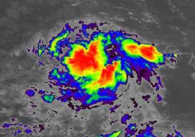
wxman57 wrote:Keep an eye on the convective burst around 11-12N. The convection will generate inflow if it persists tonight. That is where the LLC will either form under or move to. NE Caribbean is at risk of a hurricane by Friday, though it could pass just north of the Caribbean. I still don't see anything to carry it as far west as the East U.S. Coast, but I'm not ready to declare that there's no risk to the U.S. Let's see how it develops first.


Wxman thanks for your insights as usual....by the looks of this thread you would think it were destined for the United States.

FACT: it is WAY too early to say for sure.

Let's hope that Bertha is leaving enough of a weakness to carry this thing NE of the islands and out to sea.
0 likes   

weatherguru18

Re: ATL: INVEST 94L East of the Windward Islands

#422 Postby weatherguru18 » Sun Jul 13, 2008 9:40 pm

From San Juan NWS: (Snippet from Forecast Discussion this afternoon). Courtesy of DJJordan on KHOU.

...ATTENTION WILL SHIFT TO THE STRONG TROPICAL WAVE
CURRENTLY NEAR 38W. LATEST GFS AND ECMWF BOTH TRY AND DEVELOP A
CLOSED CIRCULATION WITH THIS WAVE...WITH A TRACK THAT WE WILL NEED
TO MONITOR CLOSELY. THE DEVELOPMENT OF A CLOSED CIRCULATION SEEMS
IN ALIGNMENT WITH LATEST SATELLITE IMAGERY INDICATING A WELL
DEFINED AREA OF CYCLONIC TURNING. EVEN SO...NO SIGNIFICANT
UPDATES WARRANTED TO THE EXTENDED FORECAST AT THIS TIME AS THE
EXACT TIMING AND TRACK OF ANY LOW THAT FORMS OUT OF THIS WAVE
REMAINS UNCERTAIN.
0 likes   

Matt-hurricanewatcher

Re: ATL: INVEST 94L East of the Windward Islands

#423 Postby Matt-hurricanewatcher » Sun Jul 13, 2008 9:41 pm

ROCK wrote:Matt, nice research on those surface obs....I like to use this site to look at surface waves as well as the SCAT ( which comes out later).....Surface waves at about 10N-12N at around 40W have started to take on that classic look...


http://www.oceanweather.com/data/


That is also another tool to use to kind of get a idea if a LLC is developing. Not as good but it doe's show what the obs are showing.
0 likes   

Sanibel
Category 5
Category 5
Posts: 10375
Joined: Mon Aug 30, 2004 11:06 pm
Location: Offshore SW Florida

Re: ATL: INVEST 94L East of the Windward Islands

#424 Postby Sanibel » Sun Jul 13, 2008 9:58 pm

Buoy 41026 12N-38W East wind 13Kts.


Buoy 13009 8N-38W West wind 8Kts.
0 likes   

Aric Dunn
Category 5
Category 5
Posts: 21238
Age: 42
Joined: Sun Sep 19, 2004 9:58 pm
Location: Ready for the Chase.
Contact:

Re: ATL: INVEST 94L East of the Windward Islands

#425 Postby Aric Dunn » Sun Jul 13, 2008 10:01 pm

Aric Dunn wrote:well by chance the system is sitting right in between two buoys this evening one just the north(41026) and one just to the south (13009)
anyway the only surface data depicts a closed low as the northern buoy has a east wind and the southern has a west wind.. although not very symmetrical

41026
http://www.ndbc.noaa.gov/station_page.php?station=41026

13009
http://www.ndbc.noaa.gov/station_page.php?station=13009


Image
0 likes   

Sanibel
Category 5
Category 5
Posts: 10375
Joined: Mon Aug 30, 2004 11:06 pm
Location: Offshore SW Florida

Re: ATL: INVEST 94L East of the Windward Islands

#426 Postby Sanibel » Sun Jul 13, 2008 10:06 pm

The center is probably closer to 41026 because of the higher windspeed. Should be a TD soon if it isn't already.
0 likes   

Aric Dunn
Category 5
Category 5
Posts: 21238
Age: 42
Joined: Sun Sep 19, 2004 9:58 pm
Location: Ready for the Chase.
Contact:

Re: ATL: INVEST 94L East of the Windward Islands

#427 Postby Aric Dunn » Sun Jul 13, 2008 10:11 pm

well if what im seeing is what im seeing.. than the organizing low that was semi visible earlier before the sun went down and the convection fired is hard to find first of all .. but the new convection firing near 11n 40w looks to have some curved features to it and it building northward.. which would put a possible center forming near 11n 41w still hard to tell but we will have to wait and see
..
http://www.ssd.noaa.gov/goes/flt/t2/loop-avn.html
0 likes   

Aric Dunn
Category 5
Category 5
Posts: 21238
Age: 42
Joined: Sun Sep 19, 2004 9:58 pm
Location: Ready for the Chase.
Contact:

#428 Postby Aric Dunn » Sun Jul 13, 2008 10:11 pm

no TD until they are for sure it has broken away from the ITCZ
0 likes   

User avatar
boca
Category 5
Category 5
Posts: 6367
Age: 60
Joined: Mon Dec 15, 2003 8:49 am
Location: Boca Raton,FL

Re: ATL: INVEST 94L East of the Windward Islands

#429 Postby boca » Sun Jul 13, 2008 10:12 pm

Aric Dunn wrote:well if what im seeing is what im seeing.. than the organizing low that was semi visible earlier before the sun went down and the convection fired is hard to find first of all .. but the new convection firing near 11n 40w looks to have some curved features to it and it building northward.. which would put a possible center forming near 11n 41w still hard to tell but we will have to wait and see
..
http://www.ssd.noaa.gov/goes/flt/t2/loop-avn.html


The info you posted on the buoys would be enough to warrant a depression forming I would think.
0 likes   

Aric Dunn
Category 5
Category 5
Posts: 21238
Age: 42
Joined: Sun Sep 19, 2004 9:58 pm
Location: Ready for the Chase.
Contact:

Re: ATL: INVEST 94L East of the Windward Islands

#430 Postby Aric Dunn » Sun Jul 13, 2008 10:13 pm

boca wrote:
Aric Dunn wrote:well if what im seeing is what im seeing.. than the organizing low that was semi visible earlier before the sun went down and the convection fired is hard to find first of all .. but the new convection firing near 11n 40w looks to have some curved features to it and it building northward.. which would put a possible center forming near 11n 41w still hard to tell but we will have to wait and see
..
http://www.ssd.noaa.gov/goes/flt/t2/loop-avn.html


The info you posted on the buoys would be enough to warrant a depression forming I would think.


not while its still embedded within the ITCZ
0 likes   

User avatar
ftolmsteen
Tropical Storm
Tropical Storm
Posts: 122
Joined: Mon Jun 25, 2007 6:34 am
Location: Port Richey, FL

Re: ATL: INVEST 94L East of the Windward Islands

#431 Postby ftolmsteen » Sun Jul 13, 2008 10:15 pm

IMO I still don't think this is a depression. But I do think it will be one by 11 am tomorrow.
0 likes   

Aric Dunn
Category 5
Category 5
Posts: 21238
Age: 42
Joined: Sun Sep 19, 2004 9:58 pm
Location: Ready for the Chase.
Contact:

Re: ATL: INVEST 94L East of the Windward Islands

#432 Postby Aric Dunn » Sun Jul 13, 2008 10:16 pm

ftolmsteen wrote:IMO I still don't think this is a depression. But I do think it will be one by 11 am tomorrow.


now that is possible
0 likes   

User avatar
HURAKAN
Professional-Met
Professional-Met
Posts: 46086
Age: 38
Joined: Thu May 20, 2004 4:34 pm
Location: Key West, FL
Contact:

#433 Postby HURAKAN » Sun Jul 13, 2008 10:17 pm

Image
0 likes   

User avatar
ROCK
Category 5
Category 5
Posts: 9484
Age: 54
Joined: Tue Aug 17, 2004 7:30 am
Location: Kemah, Texas

Re:

#434 Postby ROCK » Sun Jul 13, 2008 10:19 pm

HURAKAN wrote:Image


looks pretty darn close to a TD with that view. Also surface obs Matt showed had a west wind....As far as being detach from the ITCZ it looks to have done just that tonight.
0 likes   

User avatar
HURAKAN
Professional-Met
Professional-Met
Posts: 46086
Age: 38
Joined: Thu May 20, 2004 4:34 pm
Location: Key West, FL
Contact:

#435 Postby HURAKAN » Sun Jul 13, 2008 10:20 pm

Loop: http://www.ssd.noaa.gov/goes/flt/t2/loop-avn.html

Some rotation is already visible in the AVN.
0 likes   

Brent
S2K Supporter
S2K Supporter
Posts: 38089
Age: 36
Joined: Sun May 16, 2004 10:30 pm
Location: Tulsa Oklahoma
Contact:

Re:

#436 Postby Brent » Sun Jul 13, 2008 10:21 pm

HURAKAN wrote:Image


That looks good... :eek:
0 likes   

User avatar
NDG
S2K Supporter
S2K Supporter
Posts: 15446
Joined: Sun Jul 09, 2006 10:14 pm
Location: Orlando, FL

Re: ATL: INVEST 94L East of the Windward Islands

#437 Postby NDG » Sun Jul 13, 2008 10:23 pm

Aric Dunn wrote:
ftolmsteen wrote:IMO I still don't think this is a depression. But I do think it will be one by 11 am tomorrow.


now that is possible


That's what I am given it, 12-24 hrs to be a TD.
0 likes   

Sanibel
Category 5
Category 5
Posts: 10375
Joined: Mon Aug 30, 2004 11:06 pm
Location: Offshore SW Florida

Re: ATL: INVEST 94L East of the Windward Islands

#438 Postby Sanibel » Sun Jul 13, 2008 10:24 pm

Shortwave IR shows southern inflow and what looks to be faster formation than is being expressed here:


http://www.ssd.noaa.gov/goes/flt/t2/loop-ir2.html
0 likes   

Matt-hurricanewatcher

Re: ATL: INVEST 94L East of the Windward Islands

#439 Postby Matt-hurricanewatcher » Sun Jul 13, 2008 10:25 pm

Sanibel wrote:Shortwave IR shows southern inflow and what looks to be faster formation than is being expressed here:


http://www.ssd.noaa.gov/goes/flt/t2/loop-ir2.html


I agree, we need new quickscat and 85h data.
0 likes   

Jason_B

Re: ATL: INVEST 94L East of the Windward Islands

#440 Postby Jason_B » Sun Jul 13, 2008 10:27 pm

I think we're pretty close to TD status right now if not there already, probably have Cristobal by tomorrow afternoon if this organization keeps up.
0 likes   


Return to “2008”

Who is online

Users browsing this forum: No registered users and 9 guests