ATL OMAR: Remnant Low - Discussion

Moderator: S2k Moderators

Message
Author
User avatar
msbee
S2K Supporter
S2K Supporter
Posts: 3027
Joined: Wed Jun 11, 2003 10:11 am
Location: St. Maarten

Re: ATL OMAR: Hurricane - Discussion

#421 Postby msbee » Wed Oct 15, 2008 7:56 am

0 likes   

User avatar
Gustywind
Category 5
Category 5
Posts: 12334
Joined: Mon Sep 03, 2007 7:29 am
Location: Baie-Mahault, GUADELOUPE

#422 Postby Gustywind » Wed Oct 15, 2008 7:59 am

:uarrow:
Tkanks Barbara i appreciate.... :)
0 likes   

User avatar
HURAKAN
Professional-Met
Professional-Met
Posts: 46086
Age: 38
Joined: Thu May 20, 2004 4:34 pm
Location: Key West, FL
Contact:

#423 Postby HURAKAN » Wed Oct 15, 2008 8:04 am

Image
0 likes   

User avatar
Gustywind
Category 5
Category 5
Posts: 12334
Joined: Mon Sep 03, 2007 7:29 am
Location: Baie-Mahault, GUADELOUPE

#424 Postby Gustywind » Wed Oct 15, 2008 8:10 am

Wayne Verno, Lead Meteorologist, The Weather Channel
Oct. 15, 2008 6:11 am ET
The tropics remain active in the Caribbean and near Central America, as Hurricane Omar and Tropical Depression 16 continue to impact parts of the area.


Hurricane Omar

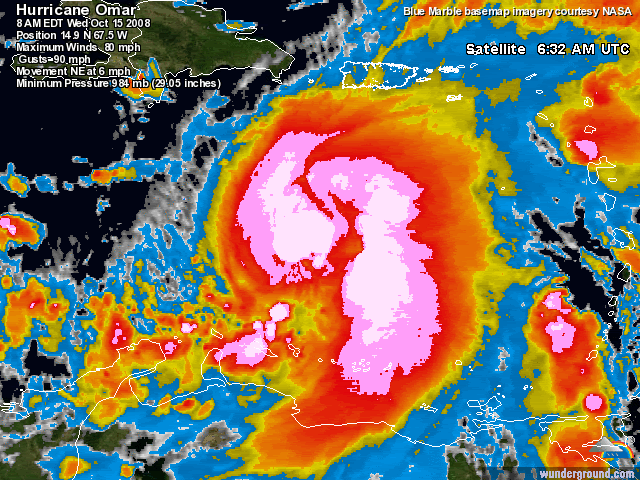
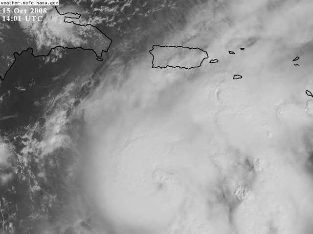
Omar strengthened to a hurricane overnight, and continues moving northeast toward the northeastern Caribbean this morning. As of 5 a.m. EDT, Hurricane Omar was located 285 miles south-southwest of San Juan, Puerto Rico, and was moving northeast at near 7 mph.

Maximum sustained winds were near 75 mph near the center, making this a category 1 hurricane on the Saffir-Simpson scale. Some additional strengthening is possible as Omar continues on a northeast track through tonight.

Local governments have posted hurricane watches and warnings as well as tropical storm watches and warnings for the islands in the northeastern Caribbean, including Puerto Rico and the U.S. and British Virgin Islands.

Conditions will begin to deteriorate in Puerto Rico and the Virgin Islands today, as outer bands begin to impact the area. On the current forecast track, Omar should pass just east of Puerto Rico tonight into early Thursday.

You can view Omar's current project path by clicking here.

As a result, expect squally weather to increase into tonight, with strong winds possible near and to the east of the center, along with heavy rain. Flash flooding and mudslides can also be expected, along with increased waves.
0 likes   

User avatar
wxman57
Moderator-Pro Met
Moderator-Pro Met
Posts: 22976
Age: 67
Joined: Sat Jun 21, 2003 8:06 pm
Location: Houston, TX (southwest)

Re:

#425 Postby wxman57 » Wed Oct 15, 2008 8:21 am

HURAKAN wrote:http://i40.photobucket.com/albums/e244/zdtadmin/Omar/ft.jpg

Eye becoming more visible?


That's not the eye. The center is well east of that bright spot. You can see it on visible imagery now, along with the convective burst to the west that you see as the bright spot on that satellite image.
0 likes   

User avatar
cycloneye
Admin
Admin
Posts: 145271
Age: 68
Joined: Thu Oct 10, 2002 10:54 am
Location: San Juan, Puerto Rico

Re: ATL OMAR: Hurricane - Discussion

#426 Postby cycloneye » Wed Oct 15, 2008 8:26 am

Look at the eye how its moving.


Image
0 likes   

User avatar
somethingfunny
ChatStaff
ChatStaff
Posts: 3926
Age: 37
Joined: Thu May 31, 2007 10:30 pm
Location: McKinney, Texas

Re: ATL OMAR: Hurricane - Discussion

#427 Postby somethingfunny » Wed Oct 15, 2008 8:29 am

Has the pressure come up since last night?
0 likes   

User avatar
Dionne
S2K Supporter
S2K Supporter
Posts: 1616
Age: 74
Joined: Mon Jan 02, 2006 8:51 am
Location: SW Mississippi....Alaska transplant via a Southern Belle.

Re: ATL OMAR: Hurricane - Discussion

#428 Postby Dionne » Wed Oct 15, 2008 8:40 am

NDBC 42059.....pressure 29.20, Sustained winds at 50.5 knots with gusts to 62 knots. Seas at 15'.
0 likes   

User avatar
KatDaddy
Category 5
Category 5
Posts: 2815
Joined: Mon Oct 21, 2002 6:23 pm
Location: League City, Texas

#429 Postby KatDaddy » Wed Oct 15, 2008 8:41 am

NDBC 42059.....peak gust of 68kts = 78mph
0 likes   

EJW
Tropical Wave
Tropical Wave
Posts: 4
Joined: Wed Oct 15, 2008 7:33 am

#430 Postby EJW » Wed Oct 15, 2008 8:42 am

Hey Everyone,

Hello from St. John, US Virgin Islands.

New to the islands and the hurricane scene.

Several posts have mentioned "convection" being a factor with Omar.

Could someone explain what that means please. What can I expect?

Thank you!
EJW
0 likes   

User avatar
HURAKAN
Professional-Met
Professional-Met
Posts: 46086
Age: 38
Joined: Thu May 20, 2004 4:34 pm
Location: Key West, FL
Contact:

#431 Postby HURAKAN » Wed Oct 15, 2008 8:50 am

Image

There it is.
0 likes   

User avatar
Crostorm
Category 5
Category 5
Posts: 2060
Age: 50
Joined: Mon Dec 25, 2006 3:51 pm
Location: Croatia-Europe
Contact:

Re: ATL OMAR: Hurricane - Discussion

#432 Postby Crostorm » Wed Oct 15, 2008 8:55 am

0 likes   

User avatar
Gustywind
Category 5
Category 5
Posts: 12334
Joined: Mon Sep 03, 2007 7:29 am
Location: Baie-Mahault, GUADELOUPE

#433 Postby Gustywind » Wed Oct 15, 2008 8:59 am

http://www.meteo.fr/temps/domtom/antill ... Tagant.jpg
Continues to improve, a feeder band is trying to form in the SE quadrant
0 likes   

Sanibel
Category 5
Category 5
Posts: 10375
Joined: Mon Aug 30, 2004 11:06 pm
Location: Offshore SW Florida

Re: ATL OMAR: Hurricane - Discussion

#434 Postby Sanibel » Wed Oct 15, 2008 9:08 am

I'm reluctant to question NHC on track because it is so precise lately, but is that eye hole slightly left to you?


Edit: Visible looks right on track. NHC on the mark once again.
Last edited by Sanibel on Wed Oct 15, 2008 9:16 am, edited 1 time in total.
0 likes   

User avatar
HURAKAN
Professional-Met
Professional-Met
Posts: 46086
Age: 38
Joined: Thu May 20, 2004 4:34 pm
Location: Key West, FL
Contact:

#435 Postby HURAKAN » Wed Oct 15, 2008 9:10 am

Image
0 likes   

Sanibel
Category 5
Category 5
Posts: 10375
Joined: Mon Aug 30, 2004 11:06 pm
Location: Offshore SW Florida

Re: ATL OMAR: Hurricane - Discussion

#436 Postby Sanibel » Wed Oct 15, 2008 9:15 am

Hey Everyone,

Hello from St. John, US Virgin Islands.

New to the islands and the hurricane scene.

Several posts have mentioned "convection" being a factor with Omar.

Could someone explain what that means please. What can I expect?

Thank you!
EJW


'Convection' is just heavy rain clouds or thunderstorms in the storm. They call it that because heat energy causes the clouds to rise or 'convect' which causes those high cloudtops seen in the hurricane satellite shots. The more energy the higher the cloudtops and the stronger the storm. So convection (dense storm clouds) is a measure of strength.

If you are new to the islands I suggest finding out about hurricane preparation from local sources -now- because you could have a hurricane coming if this shifts slightly left in track. Let us know what you experience.
0 likes   

User avatar
Gustywind
Category 5
Category 5
Posts: 12334
Joined: Mon Sep 03, 2007 7:29 am
Location: Baie-Mahault, GUADELOUPE

#437 Postby Gustywind » Wed Oct 15, 2008 9:18 am

Numerous convection is firing UP gorgeously well east of the center and should approach the islands later this afertnoon ...showing how healthy this Big Baby is:OMAR :eek: :double:
0 likes   

EJW
Tropical Wave
Tropical Wave
Posts: 4
Joined: Wed Oct 15, 2008 7:33 am

#438 Postby EJW » Wed Oct 15, 2008 9:27 am

Thank You Sanibel
EJW
0 likes   

EJW
Tropical Wave
Tropical Wave
Posts: 4
Joined: Wed Oct 15, 2008 7:33 am

#439 Postby EJW » Wed Oct 15, 2008 9:28 am

Local Forcast is 20 inches of rain btw.

EJW
St. John, USVI
0 likes   

User avatar
boca
Category 5
Category 5
Posts: 6367
Age: 60
Joined: Mon Dec 15, 2003 8:49 am
Location: Boca Raton,FL

Re: ATL OMAR: Hurricane - Discussion

#440 Postby boca » Wed Oct 15, 2008 9:30 am

It looks like Omar is moving NNE not NE on the water vapor loop.

http://www.ssd.noaa.gov/goes/east/watl/loop-wv.html

It looks like PR might get more weather than they bargained for.
0 likes   


Return to “2008”

Who is online

Users browsing this forum: No registered users and 9 guests