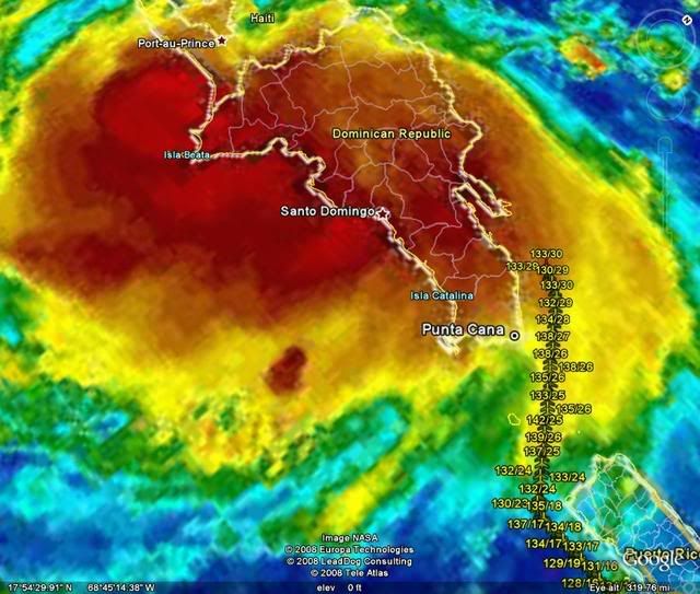
ATL: Tropical Depression Fay

Moderator: S2k Moderators

Message
Author
txag2005
Tropical Storm
Tropical Storm
Posts: 229
Joined: Thu Jul 17, 2008 1:16 am
Location: Houston, TX

Re: ATL: Tropical Storm Fay

#4761 Postby txag2005 » Fri Aug 15, 2008 11:33 pm

haml8 wrote:Local 12 (KPRC) news here in Houston started the newscast with "FAY, the storm that is going to hit the NE US" of course that was the anchor NOT the weatherman. FB actually made a point to say it was a large cone and he expected it to follow more of a WEST track off W CUBA. But that was speculation at this point. Then they mentioned Katrina due to how it was originally supposed to go into FL and ended up in NOLA. Anyway, just thought I would mention that even here in Houston we are getting coverage even though the general perception on this board by the mets is that there is only a 5% chance. Of course 5% is 5%....


I can't stand Frank Billingsley. I'll never forget how nuts he went during Rita.
0 likes   

User avatar
Blown Away
S2K Supporter
S2K Supporter
Posts: 10252
Joined: Wed May 26, 2004 6:17 am

Re: ATL: Tropical Storm Fay

#4762 Postby Blown Away » Fri Aug 15, 2008 11:33 pm

I'm amazed how confident the NHC is in not dissipating this storm after all the land interaction. They are the experts.
0 likes   

Ed Mahmoud

Re: ATL: Tropical Storm Fay

#4763 Postby Ed Mahmoud » Fri Aug 15, 2008 11:34 pm

haml8 wrote:Local 12 (KPRC) news here in Houston started the newscast with "FAY, the storm that is going to hit the NE US" of course that was the anchor NOT the weatherman. FB actually made a point to say it was a large cone and he expected it to follow more of a WEST track off W CUBA. But that was speculation at this point. Then they mentioned Katrina due to how it was originally supposed to go into FL and ended up in NOLA. Anyway, just thought I would mention that even here in Houston we are getting coverage even though the general perception on this board by the mets is that there is only a 5% chance. Of course 5% is 5%....


Billingsley is a radio/TV major who took a 60 hour online course in broadcast met from MSU. Heard of paramedics and paralegals? They are like para-meteorologists. KPRC doesn't even buy their forecasts from AccuWeather anymore.

Gene Norman has an MIT bachelors and a Maryland masters degree in meteorology, and worked at NASA, and when storms are in the Gulf, Dr Neil Frank, formerly of the NHC, comes out of retirement and offers help on and off camera. Stay with KHOU TV 11 when weather is important. IMHO.

Originally from New York, Gene holds a bachelor's degree from the Massachusetts Institute of Technology and a master's degree in meteorology from the University of Maryland.

Image
Last edited by Ed Mahmoud on Fri Aug 15, 2008 11:39 pm, edited 1 time in total.
0 likes   

User avatar
HURAKAN
Professional-Met
Professional-Met
Posts: 46086
Age: 38
Joined: Thu May 20, 2004 4:34 pm
Location: Key West, FL
Contact:

#4764 Postby HURAKAN » Fri Aug 15, 2008 11:34 pm

Image

RECON going to the north side of Hispaniola. Anyone knows why?
0 likes   

JonathanBelles
Professional-Met
Professional-Met
Posts: 11430
Age: 35
Joined: Sat Dec 24, 2005 9:00 pm
Location: School: Florida State University (Tallahassee, FL) Home: St. Petersburg, Florida
Contact:

#4765 Postby JonathanBelles » Fri Aug 15, 2008 11:35 pm

000
NOUS42 KTBW 160149
PNSTBW
FLZ039-042-043-048>052-055>057-060>062-065-161400-

PUBLIC INFORMATION STATEMENT
NATIONAL WEATHER SERVICE TAMPA BAY RUSKIN FL
949 PM EDT FRI AUG 15 2008

...ALL PERSONS IN WEST CENTRAL AND SOUTHWEST FLORIDA SHOULD
MONITOR THE LATEST TROPICAL WEATHER INFORMATION...

THE LOW PRESSURE AREA OVER HISPANIOLA HAS DEVELOPED INTO TROPICAL
STORM FAY...WHICH CONTINUES TO MOVE WEST.

COMPUTER MODELS SUGGEST THAT FAY COULD POSE A THREAT TO SOUTHWEST
AND WEST CENTRAL FLORIDA EARLY NEXT WEEK. HOWEVER...THERE IS A VERY
HIGH LEVEL OF UNCERTAINTY REGARDING THE TRACK AND INTENSITY OF THE
SYSTEM AS IT MOVES AWAY FROM HISPANIOLA AND APPROACHES CUBA OVER THE
WEEKEND. AS A RESULT...RESIDENTS AND VISITORS OF WEST CENTRAL AND
SOUTHWEST FLORIDA ARE ENCOURAGED TO KEEP A CLOSE WATCH ON THIS
SYSTEM THROUGHOUT THE UPCOMING WEEKEND.

THIS IS A GOOD TIME FOR RESIDENTS TO GO OVER THEIR HURRICANE PLANS.
VISITORS TO FLORIDA ARE ENCOURAGED TO READ UP ON INITIAL
PREPAREDNESS ACTIONS THAT MAY NEEDED. THE FOLLOWING ARE BASIC
SUGGESTED ACTIONS THAT SHOULD BE TAKEN AT THIS TIME:

CHECK BATTERIES FOR RADIOS AND FLASHLIGHTS...DRINKING WATER...CANNED
OR DRIED FOOD...FIRST AID SUPPLIES AND PRESCRIPTION MEDICINE. HAVE A
SUFFICIENT SUPPLY OF CASH AS ACCESS TO CREDIT CARDS AND AUTOMATED
CASH MACHINES MAY NOT BE AVAILABLE WITHOUT POWER. CHECK FUEL LEVELS
ON AUTOMOBILES...GENERATORS AND CHAIN SAWS.

MAKE INITIAL PLANS TO DETERMINE WHERE YOU WILL LIKELY BE IN CASE OF
AN APPROACHING STORM. CHECK WHETHER YOU LIVE IN AN EVACUATION ZONE.

FOR THE LATEST INFORMATION REGARDING FAY...PLEASE STAY TUNED TO NOAA
WEATHER RADIO...AS WELL AS INFORMATION FROM LOCAL GOVERNMENT
OFFICIALS AND MEDIA OUTLETS. YOU CAN ALSO MONITOR THE LATEST
STATEMENTS...AS WELL AS POSSIBLE WATCHES AND WARNINGS...FROM THE
NATIONAL WEATHER SERVICE OFFICE IN RUSKIN ON THE WEB AT
WEATHER.GOV/TAMPABAY. INFORMATION FROM THE NATIONAL HURRICANE CENTER
CAN BE FOUND ON WEATHER.GOV BY CLICKING ON THE HURRICANES LINK.

$$

REYNES/NOAH/MOLLEDA
0 likes   

User avatar
LaBreeze
Category 5
Category 5
Posts: 1497
Joined: Thu Sep 04, 2003 1:57 pm
Location: SW Louisiana

Re: ATL: Tropical Storm Fay

#4766 Postby LaBreeze » Fri Aug 15, 2008 11:35 pm

Could be even less than 5% - probably even less than 5% for anything west of Mississippi.
0 likes   

Sanibel
Category 5
Category 5
Posts: 10385
Joined: Mon Aug 30, 2004 11:06 pm
Location: Offshore SW Florida

Re: ATL: Tropical Storm Fay

#4767 Postby Sanibel » Fri Aug 15, 2008 11:36 pm

You can just make out the top of the center circle on this shortwave loop. Right on the NHC trop points. Headed right over the highest peaks. There is zero chance this is reforming south of the island:


http://www.ssd.noaa.gov/goes/flt/t1/loop-ir2.html
0 likes   

RL3AO
Moderator-Pro Met
Moderator-Pro Met
Posts: 16308
Joined: Thu Jun 14, 2007 10:03 pm
Location: NC

#4768 Postby RL3AO » Fri Aug 15, 2008 11:38 pm

Is recon going to cross DR on a pass? Why else would they be at 10,000 feet for a weak storm?
0 likes   

User avatar
cheezyWXguy
Category 5
Category 5
Posts: 6240
Joined: Mon Feb 13, 2006 12:29 am
Location: Dallas, TX

Re: ATL: Tropical Storm Fay

#4769 Postby cheezyWXguy » Fri Aug 15, 2008 11:39 pm

Sanibel wrote:You can just make out the top of the center circle on this shortwave loop. Right on the NHC trop points. Headed right over the highest peaks. There is zero chance this is reforming south of the island:


http://www.ssd.noaa.gov/goes/flt/t1/loop-ir2.html

wow...based on that loop, it doesnt even have to reform to get to be south of dr. Look at that drop SW!
0 likes   

User avatar
Blown Away
S2K Supporter
S2K Supporter
Posts: 10252
Joined: Wed May 26, 2004 6:17 am

Re: ATL: Tropical Storm Fay

#4770 Postby Blown Away » Fri Aug 15, 2008 11:39 pm

Convection on the NW side is crashing into the mountains and dying off, I think we will see a drastic drop off in deep convection to the S as Fay moves over the big peaks. The mountains could kick the LLC anywhere.
0 likes   

lbvbl
Tropical Storm
Tropical Storm
Posts: 119
Joined: Fri Aug 15, 2008 8:24 am

Re: ATL: Tropical Storm Fay

#4771 Postby lbvbl » Fri Aug 15, 2008 11:39 pm

what would be the difference in the track if the center did reform south of the island?
0 likes   

User avatar
haml8
Tropical Storm
Tropical Storm
Posts: 188
Age: 50
Joined: Sun Aug 19, 2007 10:03 pm
Location: Katy, Texas
Contact:

Re: ATL: Tropical Storm Fay

#4772 Postby haml8 » Fri Aug 15, 2008 11:40 pm

Ed Mahmoud wrote:
haml8 wrote:Local 12 (KPRC) news here in Houston started the newscast with "FAY, the storm that is going to hit the NE US" of course that was the anchor NOT the weatherman. FB actually made a point to say it was a large cone and he expected it to follow more of a WEST track off W CUBA. But that was speculation at this point. Then they mentioned Katrina due to how it was originally supposed to go into FL and ended up in NOLA. Anyway, just thought I would mention that even here in Houston we are getting coverage even though the general perception on this board by the mets is that there is only a 5% chance. Of course 5% is 5%....


Billingsley is a radio/TV major who took a 60 hour online course in broadcast met from MSU. Heard of paramedics and paralegals? They are like para-meteorologists. KPRC doesn't even buy their forecasts from AccuWeather anymore.

Gene Norman has an MIT and Maryland degree and worked at NASA, and when storms are in the Gulf, Dr Neil Frank, formerly of the NHC, comes out of retirement and offers help on and off camera. Stay with KHOU TV 11 when weather is important. IMHO.


We generally do, I just finished watching the Olympics on DVR, the news broadcast followed it...

In regards to Niel Frank, we always called him the hurrican shield, due to the fact that after Alicia the Galveston/Houston area has been spared, for the most part (Allison gulp), a major hurricane. I worried about him going into retirement that it might entice bad luck this year. It was comforting that he came back (Full shields captain)..
0 likes   

User avatar
HURAKAN
Professional-Met
Professional-Met
Posts: 46086
Age: 38
Joined: Thu May 20, 2004 4:34 pm
Location: Key West, FL
Contact:

#4773 Postby HURAKAN » Fri Aug 15, 2008 11:41 pm

Image

Landfall in the panhandle.
0 likes   

User avatar
cheezyWXguy
Category 5
Category 5
Posts: 6240
Joined: Mon Feb 13, 2006 12:29 am
Location: Dallas, TX

Re: ATL: Tropical Storm Fay

#4774 Postby cheezyWXguy » Fri Aug 15, 2008 11:41 pm

Blown_away wrote:Convection on the NW side is crashing into the mountains and dying off, I think we will see a drastic drop off in deep convection to the S as Fay moves over the big peaks. The mountains could kick the LLC anywhere.

Looks like it just kicked the storm on a brief wsw jump.

Anyone have radar loop?
0 likes   

Ed Mahmoud

Re: ATL: Tropical Storm Fay

#4775 Postby Ed Mahmoud » Fri Aug 15, 2008 11:41 pm

lbvbl wrote:what would be the difference in the track if the center did reform south of the island?


probably means (not definite) a further West landfall, and more time over water, less time over Cuba, to intensify.
0 likes   

User avatar
Extremeweatherguy
Category 5
Category 5
Posts: 11095
Joined: Mon Oct 10, 2005 8:13 pm
Location: Florida

Re: ATL: Tropical Storm Fay

#4776 Postby Extremeweatherguy » Fri Aug 15, 2008 11:41 pm

Sanibel wrote:You can just make out the top of the center circle on this shortwave loop. Right on the NHC trop points. Headed right over the highest peaks. There is zero chance this is reforming south of the island:


http://www.ssd.noaa.gov/goes/flt/t1/loop-ir2.html
I agree. I still think the center is where the NHC says it is.
0 likes   

User avatar
Blown Away
S2K Supporter
S2K Supporter
Posts: 10252
Joined: Wed May 26, 2004 6:17 am

Re: ATL: Tropical Storm Fay

#4777 Postby Blown Away » Fri Aug 15, 2008 11:41 pm

lbvbl wrote:what would be the difference in the track if the center did reform south of the island?


At this point 50 miles of latitude N or S could make a big difference, IMO.
0 likes   

txag2005
Tropical Storm
Tropical Storm
Posts: 229
Joined: Thu Jul 17, 2008 1:16 am
Location: Houston, TX

Re: ATL: Tropical Storm Fay

#4778 Postby txag2005 » Fri Aug 15, 2008 11:42 pm

Ed Mahmoud wrote:
haml8 wrote:Local 12 (KPRC) news here in Houston started the newscast with "FAY, the storm that is going to hit the NE US" of course that was the anchor NOT the weatherman. FB actually made a point to say it was a large cone and he expected it to follow more of a WEST track off W CUBA. But that was speculation at this point. Then they mentioned Katrina due to how it was originally supposed to go into FL and ended up in NOLA. Anyway, just thought I would mention that even here in Houston we are getting coverage even though the general perception on this board by the mets is that there is only a 5% chance. Of course 5% is 5%....


Billingsley is a radio/TV major who took a 60 hour online course in broadcast met from MSU. Heard of paramedics and paralegals? They are like para-meteorologists. KPRC doesn't even buy their forecasts from AccuWeather anymore.

Gene Norman has an MIT bachelors and a Maryland masters degree in meteorology, and worked at NASA, and when storms are in the Gulf, Dr Neil Frank, formerly of the NHC, comes out of retirement and offers help on and off camera. Stay with KHOU TV 11 when weather is important. IMHO.

Originally from New York, Gene holds a bachelor's degree from the Massachusetts Institute of Technology and a master's degree in meteorology from the University of Maryland.

Image


Wasn't Dr. Frank the head of the NHC at one point?
0 likes   

Sanibel
Category 5
Category 5
Posts: 10385
Joined: Mon Aug 30, 2004 11:06 pm
Location: Offshore SW Florida

Re: ATL: Tropical Storm Fay

#4779 Postby Sanibel » Fri Aug 15, 2008 11:43 pm

Jeesh. I can't help people who don't know how to interpret an obvious satellite loop. You can see the top part of the "eye" emerge in the last frame in the middle of the island and heading west.

We have a cyclone here. Could we do the meteorology resume's some other time?
Last edited by Sanibel on Fri Aug 15, 2008 11:44 pm, edited 1 time in total.
0 likes   

cpdaman
Category 5
Category 5
Posts: 3131
Joined: Sat Jun 10, 2006 11:44 am
Location: SPB county (gulf stream)

Re: ATL: Tropical Storm Fay

#4780 Postby cpdaman » Fri Aug 15, 2008 11:43 pm

Blown_away wrote:Convection on the NW side is crashing into the mountains and dying off, I think we will see a drastic drop off in deep convection to the S as Fay moves over the big peaks. The mountains could kick the LLC anywhere.


i agree i really don't think there will be a LLcenter in another 6 hours, unless she dives SW now.
Last edited by cpdaman on Fri Aug 15, 2008 11:44 pm, edited 1 time in total.
0 likes   


Return to “2008”

Who is online

Users browsing this forum: No registered users and 43 guests