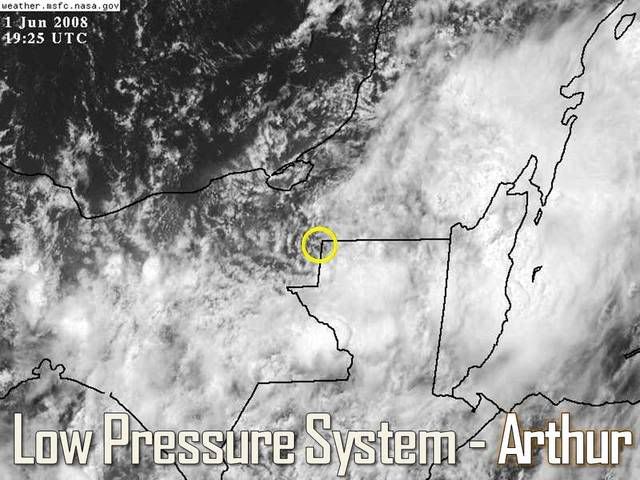
Arthur's remnents near the BOC
Moderator: S2k Moderators
-
Matt-hurricanewatcher
Re: Re:
wxman57 wrote:Cyclone1 wrote:The convection off the coast is puzzling. I'm wondering why it won't die off or move inland.
Cyclone1, take a look at a water vapor loop and I think you'll get your answer. Very dry air is spilling into the southern BoC and western Yucatan today as the ridge builds over northern Mexico and the western Gulf. As is the case with any building ridge, there's a trof downstream (across the western Caribbean). Thunderstorms are continuing to fire along the trof axis east of the Yucatan. They're not really associated with Arthur's circulation any more.
If you look at the latest surface analysis (below), there's no LLC in the western Caribbean. In fact, pressures are much higher now (up to 1014-1015mb). But we will need to watch for any persistent storms in the SW-W Caribbean this week. That large gyre spinning vort maxes across the western Caribbean could spark another Arthur-type low later this coming week:

The ob's that came along with your map shows a hint of were I think a LLC is. See near 18.4 north/91.5 or so, that there is a eastly wind to the north(Ob 1#) and there is another ob to the west showing a southly or southeastly wind. So its now kind of supported based on that. Now I don't expect it to make it over the BOC, but it maybe worth watching for a slight chance that it could and then turn into a Bret or Jose.
0 likes


-
wxman57

- Moderator-Pro Met

- Posts: 23172
- Age: 68
- Joined: Sat Jun 21, 2003 8:06 pm
- Location: Houston, TX (southwest)
Re: Re:
Matt-hurricanewatcher wrote:The ob's that came along with your map shows a hint of were I think a LLC is. See near 18.4 north/91.5 or so, that there is a eastly wind to the north(Ob 1#) and there is another ob to the west showing a southly or southeastly wind. So its now kind of supported based on that. Now I don't expect it to make it over the BOC, but it maybe worth watching for a slight chance that it could and then turn into a Bret or Jose.
I went back another frame or two in my loop and found the image below. I placed the crosshairs on 18.4N/91.5W. There probably is a large, broad circulation over the southern Yucatan that encompasses the area you mentioned. But with that ridge building down into the BoC it's having a hard time maintaining convection.

0 likes


Re: Tropical Depression Arthur in Yucatan Penninsula
Guys i see the center near over the nw tip of guatemala. seems to be having drifted sw last few hours. your thoughts. thanks
0 likes
-
wxman57
- Moderator-Pro Met
- Posts: 23172
- Age: 68
- Joined: Sat Jun 21, 2003 8:06 pm
- Location: Houston, TX (southwest)
Re: Tropical Depression Arthur in Yucatan Penninsula
tpr1967 wrote:Guys i see the center near over the nw tip of guatemala. seems to be having drifted sw last few hours. your thoughts. thanks
My guy at work is saying the same. Near 17.8N/90.8W in his estimation. Pretty poorly-organized, though. I don't know if NHC will declare it dissipated at 4pm, but they probably will by 10pm.
0 likes
-
HURAKAN

- Professional-Met

- Posts: 46084
- Age: 39
- Joined: Thu May 20, 2004 4:34 pm
- Location: Key West, FL
- Contact:
319
WHXX04 KWBC 011831
CHGQLM
ATTENTION...NATIONAL HURRICANE CENTER
NCEP COUPLED GFDL HURRICANE MODEL FORECAST MADE FOR
TROPICAL DEPRESSION ARTHUR 01L
INITIAL TIME 12Z JUN 1
DISCLAIMER ... THIS INFORMATION IS PROVIDED AS GUIDANCE. IT
REQUIRES INTERPRETATION BY HURRICANE SPECIALISTS AND SHOULD
NOT BE CONSIDERED AS A FINAL PRODUCT. PLEASE SEE THE TPC/NHC
OFFICIAL FORECAST.
FORECAST STORM POSITION
HOUR LATITUDE LONGITUDE HEADING/SPEED(KT)
0 18.0 90.4 265./ 6.0
6 18.1 90.9 276./ 5.5
12 18.1 91.2 272./ 2.8
18 18.2 91.6 285./ 3.3
24 18.4 92.5 283./ 8.7
30 18.3 93.1 262./ 5.9
36 17.9 93.2 203./ 4.1
42 17.9 93.5 273./ 2.0
48 17.5 94.1 238./ 6.8
54 17.8 94.0 6./ 2.8
60 18.1 93.9 20./ 3.2
66 18.3 94.1 319./ 2.2
72 18.5 94.3 313./ 2.5
78 18.6 94.4 313./ 2.3
84 19.0 94.4 3./ 3.8
90 19.5 94.6 339./ 5.4
96 20.1 95.1 321./ 7.3
102 20.5 95.4 326./ 5.2
108 21.1 95.8 324./ 6.3
114 22.0 96.3 329./11.2
120 23.6 97.0 337./16.9
126 24.8 98.0 321./14.5
0 likes
-
HURAKAN
- Professional-Met
- Posts: 46084
- Age: 39
- Joined: Thu May 20, 2004 4:34 pm
- Location: Key West, FL
- Contact:
652
WTNT21 KNHC 012042
TCMAT1
TROPICAL DEPRESSION ARTHUR FORECAST/ADVISORY NUMBER 6
NWS TPC/NATIONAL HURRICANE CENTER MIAMI FL AL012008
2100 UTC SUN JUN 01 2008
TROPICAL DEPRESSION CENTER LOCATED NEAR 17.7N 91.1W AT 01/2100Z
POSITION ACCURATE WITHIN 50 NM
PRESENT MOVEMENT TOWARD THE WEST-SOUTHWEST OR 245 DEGREES AT 5 KT
ESTIMATED MINIMUM CENTRAL PRESSURE 1006 MB
MAX SUSTAINED WINDS 30 KT WITH GUSTS TO 40 KT.
WINDS AND SEAS VARY GREATLY IN EACH QUADRANT. RADII IN NAUTICAL
MILES ARE THE LARGEST RADII EXPECTED ANYWHERE IN THAT QUADRANT.
REPEAT...CENTER LOCATED NEAR 17.7N 91.1W AT 01/2100Z...INLAND
AT 01/1800Z CENTER WAS LOCATED NEAR 17.8N 90.8W
FORECAST VALID 02/0600Z 17.4N 91.8W...INLAND REMNANT LOW
MAX WIND 25 KT...GUSTS 35 KT.
FORECAST VALID 02/1800Z 17.0N 92.9W...INLAND REMNANT LOW
MAX WIND 25 KT...GUSTS 35 KT.
FORECAST VALID 03/0600Z 16.9N 93.9W...INLAND REMNANT LOW
MAX WIND 20 KT...GUSTS 25 KT.
FORECAST VALID 03/1800Z 16.9N 95.0W...INLAND REMNANT LOW
MAX WIND 20 KT...GUSTS 25 KT.
FORECAST VALID 04/1800Z...DISSIPATED
REQUEST FOR 3 HOURLY SHIP REPORTS WITHIN 300 MILES OF 17.7N 91.1W
NEXT ADVISORY AT 02/0300Z
$$
FORECASTER RHOME/BEVEN
0 likes
-
HURAKAN
- Professional-Met
- Posts: 46084
- Age: 39
- Joined: Thu May 20, 2004 4:34 pm
- Location: Key West, FL
- Contact:
251
WTNT31 KNHC 012045
TCPAT1
BULLETIN
TROPICAL DEPRESSION ARTHUR ADVISORY NUMBER 6
NWS TPC/NATIONAL HURRICANE CENTER MIAMI FL AL012008
400 PM CDT SUN JUN 01 2008
...SLOW-MOVING ARTHUR STILL PRODUCING HEAVY RAINS OVER PORTIONS OF
CENTRAL AMERICA AND SOUTHEASTERN MEXICO...
AT 400 PM CDT...2100Z...THE CENTER OF TROPICAL DEPRESSION ARTHUR WAS
LOCATED NEAR LATITUDE 17.7 NORTH...LONGITUDE 91.1 WEST...OR NEAR THE
BORDER BETWEEN GUATEMALA AND MEXICO ABOUT 80 MILES...130 KM...
SOUTHEAST OF CIUDAD DEL CARMEN MEXICO.
THE DEPRESSION IS MOVING TOWARD THE WEST-SOUTHWEST NEAR 6 MPH...AND
THIS GENERAL MOTION IS EXPECTED TO CONTINUE DURING THE NEXT COUPLE
OF DAYS. ON THIS FORECAST TRACK...THE CENTER OF ARTHUR IS EXPECTED
TO REMAIN INLAND OVER SOUTHEASTERN MEXICO.
MAXIMUM SUSTAINED WINDS ARE NEAR 35 MPH...55 KM/HR...WITH HIGHER
GUSTS. THESE WINDS ARE PRIMARILY LOCATED OVER THE NORTHWESTERN
CARIBBEAN SEA EAST OF THE CENTER. WEAKENING IS FORECAST DURING THE
NEXT 24 HOURS AND ARTHUR COULD DEGENERATE INTO A REMNANT LOW LATER
TONIGHT.
ESTIMATED MINIMUM CENTRAL PRESSURE IS 1006 MB...29.71 INCHES.
ARTHUR IS EXPECTED TO PRODUCE TOTAL RAIN ACCUMULATIONS OF 5 TO 10
INCHES OVER PORTIONS OF BELIZE...GUATEMALA...AND SOUTHEASTERN MEXICO
WITH ISOLATED AMOUNTS UP TO 15 INCHES. THESE RAINS COULD CAUSE
LIFE-THREATENING FLASH FLOODS AND MUD SLIDES...ESPECIALLY IN
MOUNTAINOUS TERRAIN.
REPEATING THE 400 PM CDT POSITION...17.7 N...91.1 W. MOVEMENT
TOWARD...WEST-SOUTHWEST NEAR 6 MPH. MAXIMUM SUSTAINED WINDS...35
MPH. MINIMUM CENTRAL PRESSURE...1006 MB.
THE NEXT ADVISORY WILL BE ISSUED BY THE NATIONAL HURRICANE CENTER AT
1000 PM CDT.
$$
FORECASTER RHOME/BEVEN
0 likes
-
HURAKAN
- Professional-Met
- Posts: 46084
- Age: 39
- Joined: Thu May 20, 2004 4:34 pm
- Location: Key West, FL
- Contact:
094
WTNT41 KNHC 012047
TCDAT1
TROPICAL DEPRESSION ARTHUR DISCUSSION NUMBER 6
NWS TPC/NATIONAL HURRICANE CENTER MIAMI FL AL012008
500 PM EDT SUN JUN 01 2008
WHILE ARTHUR'S OVERALL SATELLITE APPEARANCE CONTINUES TO DEGRADE...A
RECENT REPORT FROM SHIP A8MI2 OVER THE NORTHWESTERN CARIBBEAN
INDICATES THE MAX WINDS REMAIN NEAR 30 KT. ADDITIONALLY...
CONVECTION CONTINUES OVER THE EASTERN SEMICIRCLE. THUS...THE
CYCLONE WILL BE MAINTAINED AS A TROPICAL DEPRESSION FOR THIS
ADVISORY. STILL...WITH THE CENTER OF CIRCULATION HAVING BEEN
INLAND FOR MORE THAN 24 HOURS AND INCREASINGLY HIGH TERRAIN IN ITS
ANTICIPATED PATH...ARTHUR APPEARS TO BE ON BORROWED TIME. THE
CYCLONE COULD DEGENERATE INTO A REMNANT LOW LATER TONIGHT.
THE INITIAL MOTION ESTIMATE...245/5...IS ESSENTIALLY UNCHANGED AND A
CONTINUED WEST-SOUTHWESTWARD MOTION IS EXPECTED OVER THE NEXT
COUPLE OF DAYS. ON THIS FORECAST TRACK...ARTHUR...OR ITS
REMNANTS...IS EXPECTED TO REMAIN OVER SOUTHEASTERN MEXICO. THE
OFFICIAL TRACK FORECAST IS ADJUSTED SLIGHTLY SOUTH.
ARTHUR WILL CONTINUE TO PRODUCE LOCALIZED HEAVY RAINFALL ALONG WITH
THE POTENTIAL FOR LIFE-THREATENING FLASH FLOODS AND MUD SLIDES OVER
GUATEMALA...SOUTHERN MEXICO...AND BELIZE FOR THE NEXT COUPLE OF
DAYS.
FORECAST POSITIONS AND MAX WINDS
INITIAL 01/2100Z 17.7N 91.1W 30 KT...INLAND
12HR VT 02/0600Z 17.4N 91.8W 25 KT...INLAND REMNANT LOW
24HR VT 02/1800Z 17.0N 92.9W 25 KT...INLAND REMNANT LOW
36HR VT 03/0600Z 16.9N 93.9W 20 KT...INLAND REMNANT LOW
48HR VT 03/1800Z 16.9N 95.0W 20 KT...INLAND REMNANT LOW
72HR VT 04/1800Z...DISSIPATED
$$
FORECASTER RHOME/BEVEN
0 likes
-
JonathanBelles
- Professional-Met
- Posts: 11430
- Age: 35
- Joined: Sat Dec 24, 2005 9:00 pm
- Location: School: Florida State University (Tallahassee, FL) Home: St. Petersburg, Florida
- Contact:
Re: Tropical Depression Arthur in Yucatan Penninsula
This from the EPAC:
ZCZC MIATWOEP ALL
TTAA00 KNHC DDHHMM
TROPICAL WEATHER OUTLOOK
NWS TPC/NATIONAL HURRICANE CENTER MIAMI FL
1100 AM PDT SUN JUN 1 2008
FOR THE EASTERN NORTH PACIFIC...EAST OF 140 DEGREES WEST LONGITUDE..
1. AN AREA OF DISORGANIZED SHOWERS AND THUNDERSTORMS EXTEND FROM
SOUTHERN MEXICO SOUTHWARD FOR SEVERAL HUNDRED MILES INTO THE
EASTERN PACIFIC. THERE ARE NO SIGNS OF ORGANIZATION AND
DEVELOPMENT...IF ANY...WILL BE SLOW TO OCCUR.
TROPICAL CYCLONE FORMATION IS NOT EXPECTED DURING THE NEXT 48 HOURS.
$$
FORECASTER RHOME/BEVEN
0 likes
-
JonathanBelles
- Professional-Met
- Posts: 11430
- Age: 35
- Joined: Sat Dec 24, 2005 9:00 pm
- Location: School: Florida State University (Tallahassee, FL) Home: St. Petersburg, Florida
- Contact:


Re: Tropical Depression Arthur in Yucatan Penninsula
wxman57 wrote:I'd like to make a point about low-level circulations. Just reading through the posts, I see various debates/arguments that the "LLC is here" or the "LLC is reforming there", or "You're nuts, there's no LLC there, it's here!".
I think back to one "storm" in the Caribbean maybe 3-4 years ago. It sure looked impressive on visible satellite with a "clear LLC" and winds probably at TS strength or higher. There was griping about why the NHC wasn't calling it a storm. It even looked like a storm to me. But when the recon arrived they could not find any LLC. The circulation we were all seeing was above the surface a few thousand feet or so. That's where you're looking even if you're using visible satellite - you're not necessarily seeing surface winds.
The only way to definitively state that an LLC is here or there is with surface observations. It's not wrong to say that there appears to be a surface circulation here or there based on satellite loops, but you can't declare you're right and someone else is wrong unless you have reliable surface observations across the area.
Word.
0 likes
-
HURAKAN
- Professional-Met
- Posts: 46084
- Age: 39
- Joined: Thu May 20, 2004 4:34 pm
- Location: Key West, FL
- Contact:
Re: Tropical Depression Arthur in Yucatan Penninsula
Recurve wrote:wxman57 wrote:I'd like to make a point about low-level circulations. Just reading through the posts, I see various debates/arguments that the "LLC is here" or the "LLC is reforming there", or "You're nuts, there's no LLC there, it's here!".
I think back to one "storm" in the Caribbean maybe 3-4 years ago. It sure looked impressive on visible satellite with a "clear LLC" and winds probably at TS strength or higher. There was griping about why the NHC wasn't calling it a storm. It even looked like a storm to me. But when the recon arrived they could not find any LLC. The circulation we were all seeing was above the surface a few thousand feet or so. That's where you're looking even if you're using visible satellite - you're not necessarily seeing surface winds.
The only way to definitively state that an LLC is here or there is with surface observations. It's not wrong to say that there appears to be a surface circulation here or there based on satellite loops, but you can't declare you're right and someone else is wrong unless you have reliable surface observations across the area.
Word.
If you go to this website http://wwwghcc.msfc.nasa.gov/GOES/goeseastconus.html ; then click on animate and on the general area where Arthur is located, you will immidiatelly see the LLC. Even easier to see if you click on "faster." There is no way to miss it. By the way, this LLC has lasted over land more than any I can recall. Wow.
0 likes
-
Thundercloud
- Tropical Low

- Posts: 16
- Joined: Wed May 28, 2008 8:48 pm
-
Thundercloud
- Tropical Low
- Posts: 16
- Joined: Wed May 28, 2008 8:48 pm
Re: Tropical Depression Arthur in Yucatan Penninsula
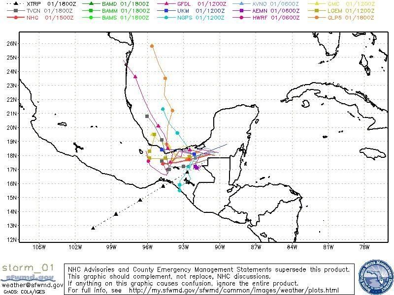
the GFDL has it getting to a hurricane with 65 knt winds


0 likes
-
Matt-hurricanewatcher
Re: Tropical Depression Arthur in Yucatan Penninsula
Thundercloud wrote:
the GFDL has it getting to a hurricane with 65 knt winds
I doubt the defined LLC will hold on for another 3 days . But the broad circulation might be strong enough to be picked up by the weakness by then. So it's worth watching. Interesting none the less.
0 likes
-
Ed Mahmoud
Re: Tropical Depression Arthur in Yucatan Penninsula
GFDL hits Tamaulipas, and the low skill climatology model implies a threat to Texas. OK, I guess that qualifies as "models".
0 likes
Who is online
Users browsing this forum: No registered users and 71 guests