ATL: IKE Discussion

Moderator: S2k Moderators

Message
Author
User avatar
hial2
S2K Supporter
S2K Supporter
Posts: 809
Joined: Fri Oct 10, 2003 9:20 pm
Location: Indian trail N.C.

Re: Re:

#5361 Postby hial2 » Mon Sep 08, 2008 10:31 am

[quote="pablolopez26"

I hope you are wrong and this thing hits somewhere else. Can you imagine Houston with no power for even 1 week? Not a pretty picture.[/quote]

Been there done that and don't ever want to do it again. 1983-Alicia[/quote]

Seriously though, id evacuate Houston for a Category 3 storm just because of the fact that being without power in Houston would be just horrible.

The way i look at it, Houston would have so many downed trees, flooding on local streets, no power, id rather be in a comfortable hotel room in Dallas for 1 week than uncomfortable dark hot and humid living room here in Houston.[/quote]


The problem is that not many Texans have the financial resources to stay in a comfortable hotel room in Dallas for a week.. :cry:
0 likes   

rtd2
Category 5
Category 5
Posts: 1183
Joined: Tue Aug 12, 2003 12:45 pm
Location: Biloxi, MS

Re: Re:

#5362 Postby rtd2 » Mon Sep 08, 2008 10:32 am

[/quote]they will raise the winds if this doesn't weaken as much as forecast, and remember the error in winds is huge...I think it will be a high cat 3 or 4 in that hot gulf low shear environment.[/quote]


[/quote]Remember too that the water south of Cuba is the warmest in the entire Atlantic basin. The difference in strength between it going over that water and over Cuba itself is night and day.[/quote]


good chance it goes BACK over cuba and we saw what the western tip of cuba did to Gustav...now if it goes between cuba and yucatan...game on
Last edited by rtd2 on Mon Sep 08, 2008 10:33 am, edited 1 time in total.
0 likes   

User avatar
jasons2k
Storm2k Executive
Storm2k Executive
Posts: 8245
Age: 51
Joined: Wed Jul 06, 2005 12:32 pm
Location: The Woodlands, TX

Re:

#5363 Postby jasons2k » Mon Sep 08, 2008 10:33 am

smw1981 wrote:Just by looking at that model graphic a few posts above this you can see that things have drastically changed in the past 4 days as far as forecast. on 09/04, All of the models showed Ike either recurving off FL's east coast or directly hitting south Florida. That didn't happen, and that was a 4 day forecast! No need to panic yet...


Yeah, because it missed the trough, hence the change.

From here on out, it's pretty straightforward. There isn't going to be a sudden shift back to MS/AL or anything like that with Ike.
0 likes   

User avatar
AJC3
Admin
Admin
Posts: 3999
Age: 61
Joined: Tue Aug 31, 2004 7:04 pm
Location: Ballston Spa, New York
Contact:

Re: Re:

#5364 Postby AJC3 » Mon Sep 08, 2008 10:34 am

Air Force Met wrote:
AJC3 wrote: I think he's just pointing out the failings of overanalyzing what NHC does or does not say in their TCDs.


Bingo....give that man a Cigar.

And you probably listen in on the calls and note the diff b/w the two sometimes. :lol:


LOL...absolutely. :lol: The TCD is only a small snippet of what's disccused between NHC, HPC, the local WFO's, the DOD, etc. Many peeps on here are under the mistaken assumption that NHC acts unilaterally. Nothing could be further from the truth. While most folks are getting the idea that NHC doesn't issue watches and warnings for other countries, many are still unaware that they don't even put them out *unilaterally* for the CONUS (as well as PR and the USVI), incuding changes therein! They *propose* them to the local WFO's, either before or during the conference call, everything has to be agreed upon before issuance of products. Most of the time, things are agreed upon, other times not so much. Sometimes the WFO will 'lean on' NHC to do something, sometimes it's the other way around.

In any event, it's a effort in futility when you try to read more into a TCD than what's actually there or not there.
Last edited by AJC3 on Mon Sep 08, 2008 10:37 am, edited 2 times in total.
0 likes   

User avatar
gboudx
S2K Supporter
S2K Supporter
Posts: 4080
Joined: Thu Sep 04, 2003 1:39 pm
Location: Rockwall, Tx but from Harvey, La

Re: Re:

#5365 Postby gboudx » Mon Sep 08, 2008 10:35 am

jinftl wrote:He actually said the track is straightforward? Miami thought the same thing thursday. Other than tracking into the Gulf, there is no way the path of Ike is a straightforward bee-line towards any one spot.


jasons wrote:I heard the confernce call from Jeff Lindner as well. Sobering to say the least. He said based in the current (then 8AM) NHC track he would put landfall just slightly right of it, maybe Jefferson County TX or Cameron. He said the NHC might adjust the track slightly left at 11AM towards Matagorda - which they did - he said if that were the case his track then would be Freeport to Pt. Bolivar. He expects this to top-out as a Cat 4, maybe it will "make a run at a Cat. 5" as he put it, and he expects LF as a large Cat 3 similar in size to Katrina, maybe Carla.

He also said the track for Ike was very straighforward and unfortunately, the setup just does not imply anything to cause a big change in the track forecast.


Yep, that's what the man said. He said the high currently steering Ike would slowly weaken on it's western edge, but then the Bermuda High would build back in int he 3-4 day timeframe. He said he didn't any troughs coming down to pick up Ike, so the path is straightforward. If you have further disagreements on this, I suggest PMing jeff directly for an explanation. But he's busy, so keep that in mind when waiting for a reply.
0 likes   

jinftl
Category 5
Category 5
Posts: 4312
Joined: Tue Aug 31, 2004 4:47 pm
Location: fort lauderdale, fl

Re: Re:

#5366 Postby jinftl » Mon Sep 08, 2008 10:36 am

The storm is over Cuba...what shift would be needed for an MS/AL landfall?

As of 11am, the NHC had the New Orleans at a higher probability of ts winds than Galveston....no sudden shift or unexpected turn is needed for a north Gulf cost landfall.


jasons wrote:
smw1981 wrote:
From here on out, it's pretty straightforward. There isn't going to be a sudden shift back to MS/AL or anything like that with Ike.
0 likes   

Wx_Warrior
Category 5
Category 5
Posts: 2718
Joined: Thu Aug 03, 2006 3:58 pm
Location: Beaumont, TX

Re: ATL IKE: Category 2 - Discussion

#5367 Postby Wx_Warrior » Mon Sep 08, 2008 10:36 am

Believe me, Entergy will have people working.
0 likes   

dwg71
Category 5
Category 5
Posts: 2349
Joined: Wed Jun 08, 2005 4:34 pm

#5368 Postby dwg71 » Mon Sep 08, 2008 10:37 am

http://www.atmos.washington.edu/~ovens/ ... nhanced+12

Weakening still occuring, and appears to have made that WNW motion. the past few frames, will have to watch. But it is still weakening.
0 likes   

User avatar
jasons2k
Storm2k Executive
Storm2k Executive
Posts: 8245
Age: 51
Joined: Wed Jul 06, 2005 12:32 pm
Location: The Woodlands, TX

Re: Re:

#5369 Postby jasons2k » Mon Sep 08, 2008 10:38 am

jinftl wrote:He actually said the track is straightforward? Miami thought the same thing thursday. Other than tracking into the Gulf, there is no way the path of Ike is a straightforward bee-line towards any one spot.


I don't recall the NHC being very confident last Thursday. There was considerable uncertianty as to whether or not Ike would turn with the trough, and if so, where.

Since Saturday the track has changed little. The only question now is as Ike approaches landfall, will the ridge be eroded enough by the next trough to induce a north jog? But by that timeframe the storm will be around 93-94W so even if it turns then, it might be Beaumont or Cameron, not SE LA or points east.
0 likes   

User avatar
WeatherNLU
Tropical Storm
Tropical Storm
Posts: 218
Joined: Fri Aug 29, 2003 12:50 pm

Re:

#5370 Postby WeatherNLU » Mon Sep 08, 2008 10:41 am

jasons wrote:I heard the confernce call from Jeff Lindner as well. Sobering to say the least. He said based in the current (then 8AM) NHC track he would put landfall just slightly right of it, maybe Jefferson County TX or Cameron. He said the NHC might adjust the track slightly left at 11AM towards Matagorda - which they did - he said if that were the case his track then would be Freeport to Pt. Bolivar. He expects this to top-out as a Cat 4, maybe it will "make a run at a Cat. 5" as he put it, and he expects LF as a large Cat 3 similar in size to Katrina, maybe Carla.

He also said the track for Ike was very straighforward and unfortunately, the setup just does not imply anything to cause a big change in the track forecast.


What a terrible situation this is shaping up to be for the Gulf Coast once again. I have a lot of friends and family in Texas now so I am desperately hoping this doesn't happen. Then again, we are on our knees here in Louisiana and a lot of people are just getting home. We have not touched anything, the trailer remains packed with supplies for me and the suitcases remain packed for the wife and kids to get out once again. New Orleans and most of the state for that matter is crippled and we just can't handle anything else right now.
0 likes   

User avatar
KWT
Category 5
Category 5
Posts: 31415
Joined: Tue Aug 17, 2004 11:02 am
Location: UK!!!

Re:

#5371 Postby KWT » Mon Sep 08, 2008 10:42 am

dwg71 wrote:http://www.atmos.washington.edu/~ovens/loops/wxloop.cgi?wv_east_enhanced+12

Weakening still occuring, and appears to have made that WNW motion. the past few frames, will have to watch. But it is still weakening.


Still looks due west on the ramsdis floater, anyway cente ris now over the water and so it shouldn't weaken anymore from now on though its going to take a little while for the core to stabalise and wrap itself back up its got enough time to do that before it ultimatly heads back inland again.

Radar also shows pretty much due west.
Last edited by KWT on Mon Sep 08, 2008 10:44 am, edited 1 time in total.
0 likes   

User avatar
jasons2k
Storm2k Executive
Storm2k Executive
Posts: 8245
Age: 51
Joined: Wed Jul 06, 2005 12:32 pm
Location: The Woodlands, TX

Re: Re:

#5372 Postby jasons2k » Mon Sep 08, 2008 10:42 am

jinftl wrote:The storm is over Cuba...what shift would be needed for an MS/AL landfall?

As of 11am, the NHC had the New Orleans at a higher probability of ts winds than Galveston....no sudden shift or unexpected turn is needed for a north Gulf cost landfall.

jasons wrote:
smw1981 wrote:
From here on out, it's pretty straightforward. There isn't going to be a sudden shift back to MS/AL or anything like that with Ike.


Those probabilities are within a certain timeframe. Don't read into them too much. They will go up for TX as time passes and we get into the 120 timeframe.
0 likes   

jinftl
Category 5
Category 5
Posts: 4312
Joined: Tue Aug 31, 2004 4:47 pm
Location: fort lauderdale, fl

Re: Re:

#5373 Postby jinftl » Mon Sep 08, 2008 10:43 am

From Friday 5pm NHC Discussion:

ALL MODELS SUGGEST SOME SORT OF WEAKNESS IN THE RIDGE NEAR FLORIDA IN A
FEW DAYS BETWEEN A RIDGE OVER THE WESTERN ATLANTIC AND THE GULF OF
MEXICO. THIS WEAKNESS MAY ALLOW A WEST-NORTHWEST OR NORTHWEST TURN
OF THE HURRICANE.

As you see, things can change. Add in the average 250 mile of error for 5-days out...the whole Gulf is at risk.


jasons wrote:
jinftl wrote:He actually said the track is straightforward? Miami thought the same thing thursday. Other than tracking into the Gulf, there is no way the path of Ike is a straightforward bee-line towards any one spot.


I don't recall the NHC being very confident last Thursday. There was considerable uncertianty as to whether or not Ike would turn with the trough, and if so, where.

Since Saturday the track has changed little. The only question now is as Ike approaches landfall, will the ridge be eroded enough by the next trough to induce a north jog? But by that timeframe the storm will be around 93-94W so even if it turns then, it might be Beaumont or Cameron, not SE LA or points east.
0 likes   

rtd2
Category 5
Category 5
Posts: 1183
Joined: Tue Aug 12, 2003 12:45 pm
Location: Biloxi, MS

Re:

#5374 Postby rtd2 » Mon Sep 08, 2008 10:44 am

dwg71 wrote:http://www.atmos.washington.edu/~ovens/loops/wxloop.cgi?wv_east_enhanced+12

Weakening still occuring, and appears to have made that WNW motion. the past few frames, will have to watch. But it is still weakening.


very leary to jump on any wobble but that LOOP looks pretty much like its started more of a wnw motion. this may keep it just onshore as it runs along cuba. may not be but a T.S. once it gets into the GOMEX
0 likes   

User avatar
HURAKAN
Professional-Met
Professional-Met
Posts: 46086
Age: 38
Joined: Thu May 20, 2004 4:34 pm
Location: Key West, FL
Contact:

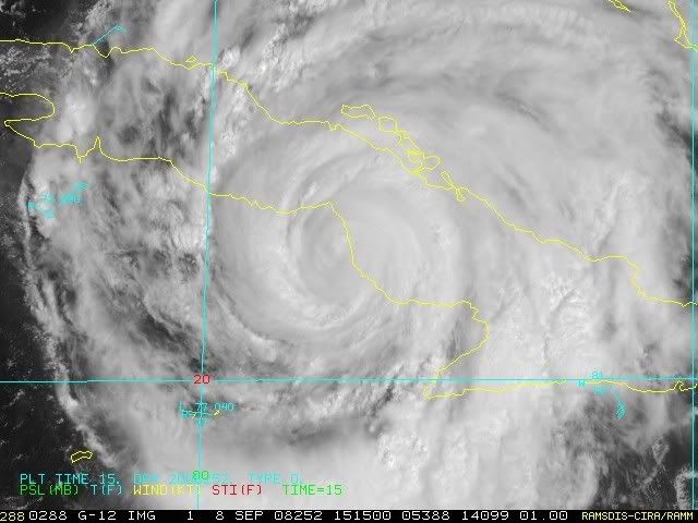
#5375 Postby HURAKAN » Mon Sep 08, 2008 10:44 am

Image

Now over the Caribbean Sea.
0 likes   

fasterdisaster
Category 5
Category 5
Posts: 1868
Joined: Mon Sep 19, 2005 4:41 pm
Location: Miami, Florida

Re: ATL IKE: Category 2 - Discussion

#5376 Postby fasterdisaster » Mon Sep 08, 2008 10:44 am

He looks better already.
0 likes   

jinftl
Category 5
Category 5
Posts: 4312
Joined: Tue Aug 31, 2004 4:47 pm
Location: fort lauderdale, fl

Re: Re:

#5377 Postby jinftl » Mon Sep 08, 2008 10:46 am

Check the numbers...i put the 120 hour cumulative probabilities

jasons wrote:
jinftl wrote:The storm is over Cuba...what shift would be needed for an MS/AL landfall?

As of 11am, the NHC had the New Orleans at a higher probability of ts winds than Galveston....no sudden shift or unexpected turn is needed for a north Gulf cost landfall.

jasons wrote:

Those probabilities are within a certain timeframe. Don't read into them too much. They will go up for TX as time passes and we get into the 120 timeframe.
0 likes   

User avatar
Tireman4
S2K Supporter
S2K Supporter
Posts: 5853
Age: 59
Joined: Fri Jun 30, 2006 1:08 pm
Location: Humble, Texas
Contact:

#5378 Postby Tireman4 » Mon Sep 08, 2008 10:49 am

During this time frame, I wanted to say that the National Hurricane Center has done a great job with forecast tracks. Things can and do change, but as of right now four months into the season, they have done a great job with the blending of models.
Last edited by Tireman4 on Mon Sep 08, 2008 10:49 am, edited 1 time in total.
0 likes   

Ed Mahmoud

Re: ATL IKE: Category 2 - Discussion

#5379 Postby Ed Mahmoud » Mon Sep 08, 2008 10:49 am

The other Jeff, Dr. Masters of Wunderground, is leaning towards Louisiana, and since his ideas match my amateur ideas, I think his reasoning is sound.

Track forecast for Ike
The Florida Keys are probably off the hook. It now looks unlikely that Ike will bring hurricane force winds to the Keys. Ike continues to move due west, and the eye may pop out to the south of Cuba at times between now and Tuesday morning. It is unlikely that the eye will move far enough from the coast for significant strengthening to occur, though. Passage over Cuba has disrupted the eyewall enough that it would take at least 12 hours over water for the storm to reorganize, and Ike probably won't get that kind of time over water. Ike is expected to track west-northwest on Tuesday into the Gulf of Mexico, passing near or over Havana, Cuba. The expected track should bring tropical storm force winds of 50-70 mph to Key West and the Lower Keys on Tuesday afternoon.

The latest 06Z (2 am EDT) computer models no longer expect a turn northward towards the Florida Panhandle. As we've seen many times this hurricane season, the models were over-enthusiastic about the intensity of a trough of low pressure passing to the north. High pressure has been dominant over the eastern U.S. the past month, and the models have consistently been underpredicting the dominance of this high pressure. The current steering pattern, with high pressure entrenched over the eastern U.S., steering hurricanes into Florida and the Gulf Coast, is similar to the steering pattern of 2004 and 2005. This steering pattern has acted to steer six straight storms into the U.S., and is not expected to change significantly over the next two weeks, according to the latest long-range forecasts from the GFS model.

As Ike moves approaches within 300 miles of the Louisiana coast on Friday, there will be another trough of low pressure capable of turning the storm to the north. The GFS, GFDL, HWRF, NOGAPS, and Canadian models all predict that this trough will be strong enough to turn Ike northwards into central or western Louisiana. The UKMET and ECMWF models disagree, and think high pressure will dominate enough to force Ike westwards into Texas, between Corpus Christi and the Louisiana border. These two models have been trending too far south with Ike so far, so I would lean towards a landfall in western Louisiana at this point.
0 likes   

User avatar
jasons2k
Storm2k Executive
Storm2k Executive
Posts: 8245
Age: 51
Joined: Wed Jul 06, 2005 12:32 pm
Location: The Woodlands, TX

Re: Re:

#5380 Postby jasons2k » Mon Sep 08, 2008 10:49 am

jinftl wrote:From Friday 5pm NHC Discussion:

ALL MODELS SUGGEST SOME SORT OF WEAKNESS IN THE RIDGE NEAR FLORIDA IN A
FEW DAYS BETWEEN A RIDGE OVER THE WESTERN ATLANTIC AND THE GULF OF
MEXICO. THIS WEAKNESS MAY ALLOW A WEST-NORTHWEST OR NORTHWEST TURN
OF THE HURRICANE.

As you see, things can change. Add in the average 250 mile of error for 5-days out...the whole Gulf is at risk.


jasons wrote:
jinftl wrote:He actually said the track is straightforward? Miami thought the same thing thursday. Other than tracking into the Gulf, there is no way the path of Ike is a straightforward bee-line towards any one spot.


I don't recall the NHC being very confident last Thursday. There was considerable uncertianty as to whether or not Ike would turn with the trough, and if so, where.

Since Saturday the track has changed little. The only question now is as Ike approaches landfall, will the ridge be eroded enough by the next trough to induce a north jog? But by that timeframe the storm will be around 93-94W so even if it turns then, it might be Beaumont or Cameron, not SE LA or points east.


Once again, it's not last week any more. If you have an issue with Jeff's comment feel free to PM him as gbdoux posted earlier. But for the umpteenth time, now Ike will round the ridge and make LF in the NW Gulf. It's not much more complicated than that.
0 likes   


Return to “2008”

Who is online

Users browsing this forum: No registered users and 6 guests