ATL OMAR: Remnant Low - Discussion

Moderator: S2k Moderators

Message
Author
Sanibel
Category 5
Category 5
Posts: 10348
Joined: Mon Aug 30, 2004 11:06 pm
Location: Offshore SW Florida

Re: ATL OMAR: Hurricane - Discussion

#541 Postby Sanibel » Wed Oct 15, 2008 8:48 pm

Almost assure an east side close pass of St Croix and hard shoulder hit of Anguilla if not hard eyewall hit. I would guess Dog Island is an unpopulated Island from the look of it - but that's ground zero.

Eye behavior might be peak now - might not.

The posts in this forum are NOT official forecast and should not be used as such. They are just the opinion of the poster and may or may not be backed by sound meteorological data. They are NOT endorsed by any professional institution or storm2k.org. For official information, please refer to the NHC and NWS products
0 likes   

User avatar
Gustywind
Category 5
Category 5
Posts: 12334
Joined: Mon Sep 03, 2007 7:29 am
Location: Baie-Mahault, GUADELOUPE

#542 Postby Gustywind » Wed Oct 15, 2008 8:49 pm

Double post from: 
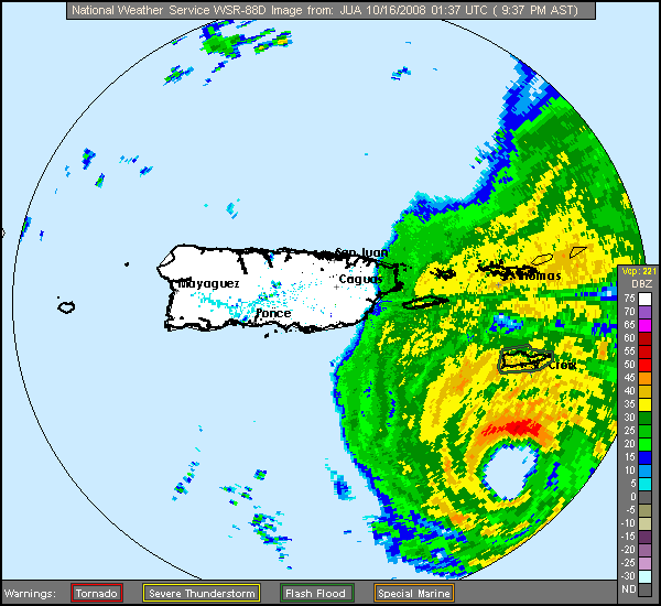
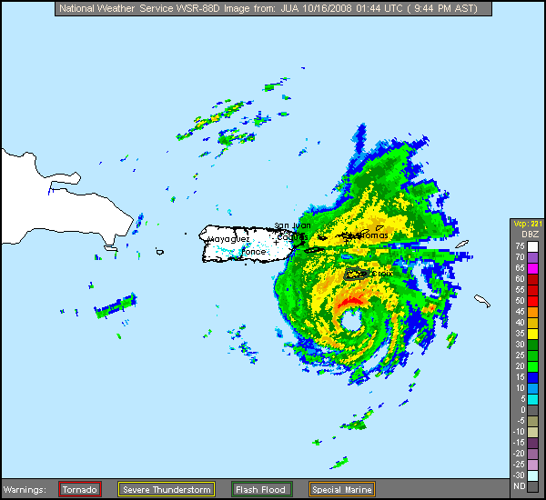
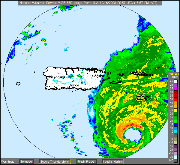
viewtopic.php?f=59&t=103576&hilit=&start=160
http://www.meteo.fr/temps/domtom/antill ... Tagant.jpg
Omar is getting closer to the BVI and the Northern Leewards Islands...

Purple alert for St Marteen meaning that things should deteriorate quickly right now as Omar is approaching dangerously... given the latest weather forecast of our Prom Met of Meteo- France: http://www.meteo.fr/temps/domtom/antill ... ivi_in.pdf
Swell with 5 meters and higher from Soutwhest and South higher is expected tonight and tommorow.
Whereas sustained winds near 55 kts are anticipated with gustywinds up to 65/82kts...
Intense rainshowers are expected too with amount near 100 to 200 millimeters and more during all the episode...
Hope the best for all Leewards , be prepared for the worst and be safe, prudent during Omar's travel...
Best thoughts positives Msbee of St Marteen...hope the very best for you!
0 likes   

User avatar
HURAKAN
Professional-Met
Professional-Met
Posts: 46086
Age: 37
Joined: Thu May 20, 2004 4:34 pm
Location: Key West, FL
Contact:

#543 Postby HURAKAN » Wed Oct 15, 2008 8:51 pm

Image

Image
0 likes   

User avatar
KatDaddy
Category 5
Category 5
Posts: 2815
Joined: Mon Oct 21, 2002 6:23 pm
Location: League City, Texas

#544 Postby KatDaddy » Wed Oct 15, 2008 8:52 pm

If the eye continues NE, St Croix will get the N and NNW eyewall which I bet has at least 115mph winds. Its one of the more intense eyewalls on radar this season.
0 likes   

User avatar
wxman57
Moderator-Pro Met
Moderator-Pro Met
Posts: 22506
Age: 66
Joined: Sat Jun 21, 2003 8:06 pm
Location: Houston, TX (southwest)

Re:

#545 Postby wxman57 » Wed Oct 15, 2008 8:54 pm

fact789 wrote:I cannot see from the NHC map, but which islands are closest to the NHC track right now?


Here's a map I made in Streets & Trips. I measured distances to the major islands (in miles) perpendicular to the track. It looks like Omar may track a little right of the forecast, putting it just east of St. Croix and possibly through a gap in the islands.

Image
0 likes   

User avatar
HURAKAN
Professional-Met
Professional-Met
Posts: 46086
Age: 37
Joined: Thu May 20, 2004 4:34 pm
Location: Key West, FL
Contact:

#546 Postby HURAKAN » Wed Oct 15, 2008 8:55 pm

Image

St. Croix looks to be in a bad position.
0 likes   

Sanibel
Category 5
Category 5
Posts: 10348
Joined: Mon Aug 30, 2004 11:06 pm
Location: Offshore SW Florida

Re: ATL OMAR: Hurricane - Discussion

#547 Postby Sanibel » Wed Oct 15, 2008 9:00 pm

The eye is scary the way it wobbles loose then wraps tight and round in pulses.


Totally amateur unprofessional view: I think BVI dodged a bullet.
Last edited by Sanibel on Wed Oct 15, 2008 9:01 pm, edited 1 time in total.
0 likes   

User avatar
wxman57
Moderator-Pro Met
Moderator-Pro Met
Posts: 22506
Age: 66
Joined: Sat Jun 21, 2003 8:06 pm
Location: Houston, TX (southwest)

Re: ATL OMAR: Hurricane - Discussion

#548 Postby wxman57 » Wed Oct 15, 2008 9:00 pm

St. Croix decoded obs (TISX):

TISX| |160153|75.0F|73.9F|96.5%|030|028|038|29.56|999|OVC|Heavy Rain , Mist
TISX| |160145|75.0F|75.0F|100.0%|040|024|032|29.59|999|OVC|Heavy Rain , Mist
TISX| |160140|75.0F|75.0F|100.0%|040|024|032|29.59|999|OVC|Heavy Rain , Mist
TISX| |160116|75.0F|75.0F|100.0%|040|021|037|29.63|999|OVC|Heavy Rain , Mist

Latest wind 030 28 gusting 38 kts. Not even TS force sustained wind yet. Small storm.
0 likes   

User avatar
HURAKAN
Professional-Met
Professional-Met
Posts: 46086
Age: 37
Joined: Thu May 20, 2004 4:34 pm
Location: Key West, FL
Contact:

#549 Postby HURAKAN » Wed Oct 15, 2008 9:01 pm

Image
0 likes   

User avatar
KatDaddy
Category 5
Category 5
Posts: 2815
Joined: Mon Oct 21, 2002 6:23 pm
Location: League City, Texas

#550 Postby KatDaddy » Wed Oct 15, 2008 9:01 pm

With a powerhouse eyewall. Reminds me of Humberto.
0 likes   

superfly
Category 4
Category 4
Posts: 938
Joined: Wed Aug 03, 2005 2:13 pm
Location: New Orleans, LA

Re: ATL OMAR: Hurricane - Discussion

#551 Postby superfly » Wed Oct 15, 2008 9:02 pm

The eye is finally starting to clear out on satellite images.

Image
0 likes   

User avatar
caribepr
Category 5
Category 5
Posts: 1794
Joined: Fri Sep 05, 2003 10:43 pm
Location: Culebra, PR 18.33 65.33

#552 Postby caribepr » Wed Oct 15, 2008 9:05 pm

Gotta say...I love that graphic (the still image), despite everything. I've never said that before but wow! What a great t-shirt!

The rain is becoming a bit more consistant, wind picking up a bit more. We're very, very fortunate, unfortunate for those to our east.
0 likes   

Sanibel
Category 5
Category 5
Posts: 10348
Joined: Mon Aug 30, 2004 11:06 pm
Location: Offshore SW Florida

Re: ATL OMAR: Hurricane - Discussion

#553 Postby Sanibel » Wed Oct 15, 2008 9:08 pm

The ULL could have a slight nudge east as it tracks giving St Martins a good share of this too possibly.


The posts in this forum are NOT official forecast and should not be used as such. They are just the opinion of the poster and may or may not be backed by sound meteorological data. They are NOT endorsed by any professional institution or storm2k.org. For official information, please refer to the NHC and NWS products.
0 likes   

User avatar
KatDaddy
Category 5
Category 5
Posts: 2815
Joined: Mon Oct 21, 2002 6:23 pm
Location: League City, Texas

#554 Postby KatDaddy » Wed Oct 15, 2008 9:11 pm

Aggggggggggggg! Lost the San Juan radar
0 likes   

User avatar
HURAKAN
Professional-Met
Professional-Met
Posts: 46086
Age: 37
Joined: Thu May 20, 2004 4:34 pm
Location: Key West, FL
Contact:

#555 Postby HURAKAN » Wed Oct 15, 2008 9:14 pm

Image
0 likes   

User avatar
KatDaddy
Category 5
Category 5
Posts: 2815
Joined: Mon Oct 21, 2002 6:23 pm
Location: League City, Texas

#556 Postby KatDaddy » Wed Oct 15, 2008 9:18 pm

We have the San Juan radar back and St Croix is going to take a pounding by Omar's eyewall in the next 1-2 hours.
0 likes   

User avatar
caribepr
Category 5
Category 5
Posts: 1794
Joined: Fri Sep 05, 2003 10:43 pm
Location: Culebra, PR 18.33 65.33

Re: ATL OMAR: Hurricane - Discussion

#557 Postby caribepr » Wed Oct 15, 2008 9:35 pm

Getting a bit more frisky here...Image
0 likes   

User avatar
Gustywind
Category 5
Category 5
Posts: 12334
Joined: Mon Sep 03, 2007 7:29 am
Location: Baie-Mahault, GUADELOUPE

#558 Postby Gustywind » Wed Oct 15, 2008 9:37 pm

000
AXNT20 KNHC 152359
TWDAT

TROPICAL WEATHER DISCUSSION
NWS TPC/NATIONAL HURRICANE CENTER MIAMI FL
805 PM EDT WED OCT 15 2008

TROPICAL WEATHER DISCUSSION FOR NORTH AMERICA...CENTRAL
AMERICA...GULF OF MEXICO...CARIBBEAN SEA...NORTHERN SECTIONS OF
SOUTH AMERICA...AND ATLANTIC OCEAN TO THE AFRICAN COAST FROM THE
EQUATOR TO 32N. THE FOLLOWING INFORMATION IS BASED ON SATELLITE
IMAGERY...METEOROLOGICAL ANALYSIS...WEATHER OBSERVATIONS...AND
RADAR.

BASED ON 1800 UTC SURFACE ANALYSIS AND SATELLITE IMAGERY THROUGH
2315 UTC.

...SPECIAL FEATURES...
HURRICANE OMAR IS CENTERED NEAR 16.6N 65.2W AT 16/0000 UTC OR
ABOUT 70 NM SOUTH-SOUTHWEST OF ST. CROIX AND ABOUT 115 NM SOUTH-
SOUTHEAST OF SAN JUAN PUERTO RICO MOVING NE AT 15 KT. ESTIMATED
MINIMUM CENTRAL PRESSURE IS 971 MB. MAXIMUM SUSTAINED WIND SPEED
IS 90 KT WITH HIGHER GUSTS. PLEASE SEE LATEST NHC PUBLIC
ADVISORY UNDER AWIPS/WMO HEADERS MIATCPAT5/WTNT35 KNHC AND THE
FULL FORECAST/ADVISORY UNDER AWIPS/WMO HEADERS MIATCMAT5/WTNT25
KNHC FOR MORE DETAILS. NUMEROUS STRONG CONVECTION IS WITHIN 120
NM OF THE CENTER IN THE NE QUADRANT. SCATTERED MODERATE/STRONG
CONVECTION COVERS THE REMAINDER OF THE AREA FROM 12N-21N BETWEEN
59W-68W. OMAR IS FORECAST TO TRACK NE THROUGH THE NRN LEEWARD
AND VIRGIN ISLANDS LATE TONIGHT AND EARLY THURSDAY.
0 likes   

User avatar
KatDaddy
Category 5
Category 5
Posts: 2815
Joined: Mon Oct 21, 2002 6:23 pm
Location: League City, Texas

#559 Postby KatDaddy » Wed Oct 15, 2008 9:37 pm

Currently looks like the eyewall will be just SE of St Croix.
0 likes   

Ed Mahmoud

Re: ATL OMAR: Hurricane - Discussion

#560 Postby Ed Mahmoud » Wed Oct 15, 2008 9:37 pm

caribepr wrote:Getting a bit more frisky here...Image


I'll say...
0 likes   


Return to “2008”

Who is online

Users browsing this forum: No registered users and 8 guests