Arthur's remnents near the BOC

Moderator: S2k Moderators

Message
Author
User avatar
srainhoutx
S2K Supporter
S2K Supporter
Posts: 6919
Age: 67
Joined: Sun Jan 14, 2007 11:34 am
Location: Haywood County, NC
Contact:

Re:

#561 Postby srainhoutx » Sun Jun 01, 2008 10:08 pm

HURAKAN wrote:Just like in 1961. Hattie-Simone-Inga

Image


Would shutter to think of a Carla type system on Upper TX Coast now. Bite your tongue. :ggreen:
Last edited by srainhoutx on Sun Jun 01, 2008 10:13 pm, edited 1 time in total.
0 likes   

Ad Novoxium
Category 1
Category 1
Posts: 348
Age: 35
Joined: Sat May 03, 2008 2:12 am

#562 Postby Ad Novoxium » Sun Jun 01, 2008 10:10 pm

Arthur is dead. Now it can join the ranks of Ana and Beryl as the third five-time use name in the Atlantic in which none of the usages were for hurricanes.
0 likes   

Sanibel
Category 5
Category 5
Posts: 10375
Joined: Mon Aug 30, 2004 11:06 pm
Location: Offshore SW Florida

Re: Arthur dissipates over Mexico/Guatemala border

#563 Postby Sanibel » Sun Jun 01, 2008 11:30 pm

GFDL continues to show cyber wishcast tendencies...


Arthur appears to have a large sized circulation area including black-topped IR even after 36 hours over land. This could be some season ahead.
0 likes   

Sanibel
Category 5
Category 5
Posts: 10375
Joined: Mon Aug 30, 2004 11:06 pm
Location: Offshore SW Florida

Re: Arthur dissipates over Mexico/Guatemala border

#564 Postby Sanibel » Mon Jun 02, 2008 9:20 am

An active center is still spinning just SW of 18-91

This system is unusual in its strength considering the land interaction forces on it. It still has a convection outbreak over the Caribbean 48 hours after going inland. It will either just emerge in the very southern BOC or stay just inland.
0 likes   

Ed Mahmoud

Re: Arthur dissipates over Mexico/Guatemala border

#565 Postby Ed Mahmoud » Mon Jun 02, 2008 9:26 am

I don't think the warmer waters off Texas are deep enough to support a Carla type system in early June.


Just waiting for wxman57 and Dr. McCoy to arrive to make it official...
0 likes   

Sanibel
Category 5
Category 5
Posts: 10375
Joined: Mon Aug 30, 2004 11:06 pm
Location: Offshore SW Florida

Re: Arthur dissipates over Mexico/Guatemala border

#566 Postby Sanibel » Mon Jun 02, 2008 9:29 am

The size and strength of this system are evident in its ability to create deep convection both in the Pacific and Caribbean while the center is over land. This system would have been strong had it stayed over water and tracked towards the US.
0 likes   

User avatar
tailgater
S2K Supporter
S2K Supporter
Posts: 3339
Joined: Sun Jul 11, 2004 9:13 pm
Location: St. Amant La.

Re: Arthur dissipates over Mexico/Guatemala border

#567 Postby tailgater » Mon Jun 02, 2008 9:30 am

When is there suppose to be a SE-NW flow down to the BOC, 2 days 3, if longer I don't think it will matter for Arthur remnants. Yesterday's Visible loop showed a very large circulation, some of it may had been part of the trough in that region, but it was huge.
0 likes   

Ed Mahmoud

Re: Arthur dissipates over Mexico/Guatemala border

#568 Postby Ed Mahmoud » Mon Jun 02, 2008 9:32 am

No massive hurricanes for Texas anytime in the next week or two, even if the Mother of All Super-Mondo ridges wasn't over the state.


Image


In my humble and amateur opinion.
0 likes   

User avatar
Chacor
Category 5
Category 5
Posts: 10229
Joined: Mon Oct 02, 2006 10:43 pm
Location: Singapore

#569 Postby Chacor » Mon Jun 02, 2008 9:45 am

With the amount of dry air in the GoM... it's not going to happen. That EPac disturbance is looking increasingly good though.

Image
0 likes   

User avatar
Extremeweatherguy
Category 5
Category 5
Posts: 11095
Joined: Mon Oct 10, 2005 8:13 pm
Location: Florida

#570 Postby Extremeweatherguy » Mon Jun 02, 2008 10:26 am

Youtube video of tropical storm Arthur impacting Belize yesterday...

http://www.youtube.com/watch?v=2pC8QGyxkNw
0 likes   

JonathanBelles
Professional-Met
Professional-Met
Posts: 11430
Age: 35
Joined: Sat Dec 24, 2005 9:00 pm
Location: School: Florida State University (Tallahassee, FL) Home: St. Petersburg, Florida
Contact:

#571 Postby JonathanBelles » Mon Jun 02, 2008 10:27 am

Alma/Arthur have a new number now!
0 likes   

User avatar
srainhoutx
S2K Supporter
S2K Supporter
Posts: 6919
Age: 67
Joined: Sun Jan 14, 2007 11:34 am
Location: Haywood County, NC
Contact:

Re: Tropical Depression Arthur in Yucatan Penninsula

#572 Postby srainhoutx » Mon Jun 02, 2008 10:41 am

srainhoutx wrote:
wxman57 wrote:Time to put a fork in Arthur. Might be a shot of some redevelopment from its remnants in the East Pac, but for all practical purposes...

Image

:roflmao: :roflmao: :roflmao:

welcome back wxman57


No wait, it's 91E
0 likes   

User avatar
drezee
S2K Supporter
S2K Supporter
Posts: 3664
Joined: Mon Jun 09, 2003 12:49 pm
Location: FL

Re: Arthur dissipates over Mexico/Guatemala border

#573 Postby drezee » Mon Jun 02, 2008 12:03 pm

Arthur is dead....but whatever of a center it has left has turned NW and is at 18.1 and 91.8.

Last official position was LOCATED NEAR 17.4N 91.3W AT 02/0300Z
0 likes   

User avatar
tailgater
S2K Supporter
S2K Supporter
Posts: 3339
Joined: Sun Jul 11, 2004 9:13 pm
Location: St. Amant La.

Re: Arthur dissipates over Mexico/Guatemala border

#574 Postby tailgater » Mon Jun 02, 2008 12:22 pm

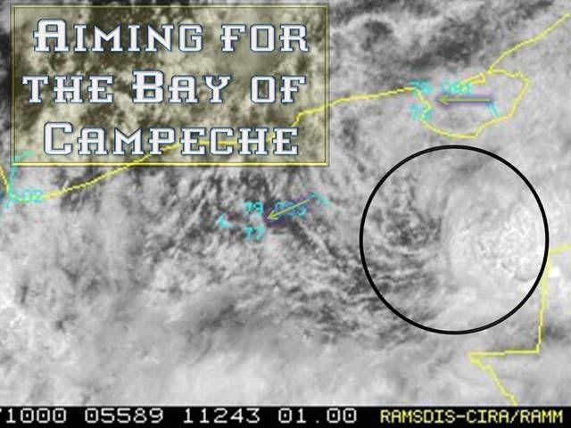
drezee wrote:Arthur is dead....but whatever of a center it has left has turned NW and is at 18.1 and 91.8.

Last official position was LOCATED NEAR 17.4N 91.3W AT 02/0300Z


Yeah I was just looking at vis sat loop, I can't detect a motion yet but the location is same as what I had. The water vapor loop shows a small ULL diving SWard which might pull it northward for a while.
0 likes   

CrazyC83
Professional-Met
Professional-Met
Posts: 34002
Joined: Tue Mar 07, 2006 11:57 pm
Location: Deep South, for the first time!

#575 Postby CrazyC83 » Mon Jun 02, 2008 12:38 pm

ZCZC MIATWOAT ALL
TTAA00 KNHC DDHHMM
TROPICAL WEATHER OUTLOOK
NWS TPC/NATIONAL HURRICANE CENTER MIAMI FL
800 AM EDT MON JUN 2 2008

FOR THE NORTH ATLANTIC...CARIBBEAN SEA AND THE GULF OF MEXICO...

1. THE REMNANTS OF ARTHUR CONTINUE TO PRODUCE HEAVY RAINS OVER PORTIONS
OF BELIZE...GUATEMALA...AND SOUTHEASTERN MEXICO. WHILE
REDEVELOPMENT OF THIS SYSTEM IS NOT EXPECTED...ASSOCIATED HEAVY
RAINS COULD CAUSE LIFE-THREATENING FLASH FLOODS AND MUD SLIDES...
ESPECIALLY IN MOUNTAINOUS TERRAIN...DURING THE NEXT COUPLE OF DAYS
AS IT MOVES SLOWLY WESTWARD.

ELSEWHERE...TROPICAL CYCLONE FORMATION IS NOT EXPECTED DURING THE
NEXT 48 HOURS.

$$
FORECASTER RHOME
0 likes   

User avatar
gatorcane
S2K Supporter
S2K Supporter
Posts: 23691
Age: 47
Joined: Sun Mar 13, 2005 3:54 pm
Location: Boca Raton, FL

#576 Postby gatorcane » Mon Jun 02, 2008 12:41 pm

000
ABPZ20 KNHC 021723
TWOEP
TROPICAL WEATHER OUTLOOK
NWS TPC/NATIONAL HURRICANE CENTER MIAMI FL
1100 AM PDT MON JUN 2 2008

FOR THE EASTERN NORTH PACIFIC...EAST OF 140 DEGREES WEST LONGITUDE..

SHOWERS AND THUNDERSTORMS HAVE BECOME BETTER ORGANIZED NEAR THE GULF
OF TEHUANTEPEC WITHIN A BROADER AREA OF DISTURBED WEATHER SOUTH OF
MEXICO. CONDITIONS APPEAR FAVORABLE FOR ADDITIONAL DEVELOPMENT...
AND A TROPICAL DEPRESSION COULD FORM DURING THE NEXT DAY OR TWO.
REGARDLESS OF DEVELOPMENT...LOCALLY HEAVY RAINS ARE POSSIBLE OVER
PORTIONS OF EL SALVADOR...GUATEMALA...AND SOUTHEASTERN MEXICO AS
THE SYSTEM DRIFTS NORTHWARD OR REMAINS NEARLY STATIONARY.

ELSEWHERE...TROPICAL CYCLONE FORMATION IS NOT EXPECTED DURING THE
NEXT 48 HOURS.

$$
FORECASTER RHOME/FRANKLIN
0 likes   

User avatar
wxwatcher91
Category 5
Category 5
Posts: 1606
Joined: Wed Jul 06, 2005 2:43 pm
Location: Keene, NH
Contact:

#577 Postby wxwatcher91 » Mon Jun 02, 2008 2:04 pm

If anyone is curious, Arthur contributed to an incredible ACE of .49.

Better start updating those forecasts :lol:
0 likes   

User avatar
HURAKAN
Professional-Met
Professional-Met
Posts: 46086
Age: 38
Joined: Thu May 20, 2004 4:34 pm
Location: Key West, FL
Contact:

#578 Postby HURAKAN » Mon Jun 02, 2008 2:16 pm

Image

Loop: http://hadar.cira.colostate.edu/ramsdis ... ive_0.html

Looks like the remnents of Arthurs are tying to get back to water.
0 likes   

RL3AO
Moderator-Pro Met
Moderator-Pro Met
Posts: 16308
Joined: Thu Jun 14, 2007 10:03 pm
Location: NC

#579 Postby RL3AO » Mon Jun 02, 2008 2:19 pm

Still has a decent looking circulation.
0 likes   

User avatar
KWT
Category 5
Category 5
Posts: 31415
Joined: Tue Aug 17, 2004 11:02 am
Location: UK!!!

#580 Postby KWT » Mon Jun 02, 2008 2:53 pm

Even if that is Arthurs remains if 91E forms it will finish whatever circulation is left by shearing it, esp given 91E is heading northwards at the moment.
0 likes   


Return to “2008”

Who is online

Users browsing this forum: No registered users and 6 guests