http://www.ssd.noaa.gov/goes/flt/t2/loop-vis.html
I am seeing what looks to be an eye forming...
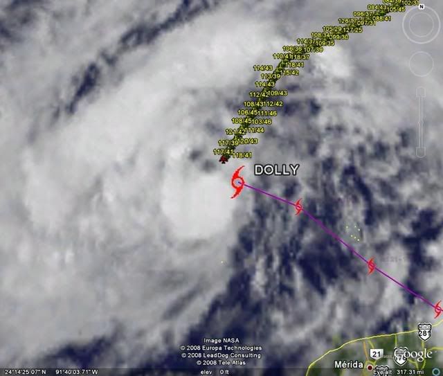
ATL: Tropical Depression Dolly
Moderator: S2k Moderators
-
Nederlander
- S2K Supporter

- Posts: 1259
- Joined: Sat Jul 19, 2008 4:28 pm
- Location: Conroe, TX

I think AFM we already seeing hints of that occuring with the development of the inner core and with it having very good bandings it may well strengthen pretty rapidly IMO, esp if it can gain some convection like its doing already.
FWIW the models all seem to agree that this won't really take off till a little further WNW, I think thats why the NHC doesn't call for much strengthening in the next 12-18hrs.
FWIW the models all seem to agree that this won't really take off till a little further WNW, I think thats why the NHC doesn't call for much strengthening in the next 12-18hrs.
0 likes

While I don't know a lot about a lot...I do know something Derek said lo so many pages ago made huge sense to me and it seems to have been overlooked like...a lot of things concerning this system. I can't quote exactly (because I'm too lazy to go back and find it) but it was along the lines of - look at the big picture and not every little thing that happens along the way.
I think that is something missing in the last few dozen pages that was present in the beginning and middle, even with the ups and downs of what might happen, making it informative and interesting; even the disagreements were consolidated into learning for all.
BIG PICTURE...like what grown ups try to tell children and of course never get heard, because that picture takes time, patience, knowledge, experience. Difference being, saying...this is happening now, I see this at this moment, what do you all see?. Rather than, this is happening now, so that will happen then, full stop.
For awhile we had maybe, what, five or six pro mets joining in this particular thread (to whomever said something about one of the pros "joining the boards" - that person did), and now I think most have gone to the analysis thread, where some really pertinent info can be gleaned. Just something to think about.
And, while I'm not in the Yucatan, or Texas, or Guadaloupe (where 12 people died, by the way, from this weather that is real, regardless of its status), I am in a place where, when whatever system eventually comes here, I want to be able to read the immediate future as best as possible, as everyone, in every area that could be affected wants to do.
Think before you post, please.
0 likes
-
Texas Snowman

- Storm2k Moderator

- Posts: 6197
- Joined: Fri Jan 25, 2008 11:29 am
- Location: Denison, Texas
Re: ATL: TS Dolly in Southern Gulf of Mexico
KWT,
You're right about the northern eyewall impacting BRO, McAllen, etc.
But I'm thinking that the biggest impact from a Cat 1 or 2 strike in the RGV will be from rainfall more so than wind and storm surge issues (certainly Port Isabel and South Padre island residents would disagree with that).
The biggest problem is the huge developement that has taken place since Beulah hit there in 1967. The RGV has many more residents, homes, and businesses than it did 41 years ago.
And South Padre Island is a glittering jewel of sand, water, businesses, hotels, and condos.
Heaven help us if Dolly somehow strengthens into a Cat 3 and hits that area.
0 likes

-
Texas Snowman
- Storm2k Moderator
- Posts: 6197
- Joined: Fri Jan 25, 2008 11:29 am
- Location: Denison, Texas
Re: ATL: TS Dolly in Southern Gulf of Mexico
I've been thinking that we were seeing the beginnings of an eye wall for some time. Not sure if that's what it is just yet, but it looks the part.
Also interesting to note that Brett formed an eye as a Tropical Storm in 1999 and we all remember how explosive his development was.
Also interesting to note that Brett formed an eye as a Tropical Storm in 1999 and we all remember how explosive his development was.
0 likes

-
Matt-hurricanewatcher
Re: ATL: TS Dolly in Southern Gulf of Mexico
Innercore developing with the first signs of a "CDO" forming over the center. Outflow is very very good to the north and east. I expect this could be a hurricane with in 12-15 hours.
0 likes
-
paintplaye
- Category 1

- Posts: 380
- Joined: Sun Jul 20, 2008 11:25 pm
Re: ATL: TS Dolly in Southern Gulf of Mexico
I don't know but i defiantly see a NW movement. Watch the last couple of frames.
0 likes
-
CrazyC83
- Professional-Met

- Posts: 34315
- Joined: Tue Mar 07, 2006 11:57 pm
- Location: Deep South, for the first time!
Re: ATL: TS Dolly in Southern Gulf of Mexico
Texas Snowman wrote:I've been thinking that we were seeing the beginnings of an eye wall for some time. Not sure if that's what it is just yet, but it looks the part.
Also interesting to note that Brett formed an eye as a Tropical Storm in 1999 and we all remember how explosive his development was.
That's been my thinking all along. I wouldn't be surprised to see a very dangerous hurricane within 24-30 hours.
0 likes
-
txwatcher91
- Category 5

- Posts: 1498
- Joined: Tue Aug 02, 2005 2:29 pm
-
Air Force Met
- Military Met

- Posts: 4372
- Age: 57
- Joined: Tue Jul 08, 2003 9:30 am
- Location: Roan Mountain, TN
Re:
KWT wrote:I think AFM we already seeing hints of that occuring with the development of the inner core and with it having very good bandings it may well strengthen pretty rapidly IMO, esp if it can gain some convection like its doing already.
FWIW the models all seem to agree that this won't really take off till a little further WNW, I think thats why the NHC doesn't call for much strengthening in the next 12-18hrs.
I agree. When I mean convectively getting its act together...I don't mean just some good thunderstorms and a steady drop in pressure...I mean hold on to your seats because the conditions are very good for explosive development and a big drop in pressure....and a nice cold CDO to go along with it.
0 likes


-
Brent
- S2K Supporter
- Posts: 38732
- Age: 37
- Joined: Sun May 16, 2004 10:30 pm
- Location: Tulsa Oklahoma
- Contact:
Re: ATL: TS Dolly in Southern Gulf of Mexico
WHOA, just glanced at the satellite. Huge improvement in appearance even in just the last hour. 
I think it's going to shed those weakening outer bands tonight and look more like a classic storm tomorrow, probably become a hurricane also.
I think it's going to shed those weakening outer bands tonight and look more like a classic storm tomorrow, probably become a hurricane also.
0 likes
Re: ATL: TS Dolly in Southern Gulf of Mexico
Matt-hurricanewatcher wrote:Innercore developing with the first signs of a "CDO" forming over the center. Outflow is very very good to the north and east. I expect this could be a hurricane with in 12-15 hours.
It definitely has gotten its act together in the last few hours. Much better looking than it this time yesterday.
0 likes
-
Tampa Bay Hurricane

- Category 5
- Posts: 5597
- Age: 38
- Joined: Fri Jul 22, 2005 7:54 pm
- Location: St. Petersburg, FL
***NOT OFFICIAL****
Convection is certainly getting much stronger around the center
of this tropical storm. I expect that this will strengthen to a hurricane
pretty quickly. Residents in Texas need to be preparing. I can not
stress that enough. The possibility for rapid intensification, especially
if that blow-up near the center continues, is there and needs to be
monitored very closely by Texas/North Mex Residents.
Given oceanic heat content, and a favorable ridge to the NE,
I expect rapid intensification to a potentially dangerous hurricane
prior to landfall. Once the convection surrounds the center
and intensifies, this tropical storm could quickly become
a very dangerous hurricane of Category 3 strength.
Last edited by Tampa Bay Hurricane on Mon Jul 21, 2008 5:49 pm, edited 1 time in total.
0 likes
Re: Re:
Air Force Met wrote:KWT wrote:I think AFM we already seeing hints of that occuring with the development of the inner core and with it having very good bandings it may well strengthen pretty rapidly IMO, esp if it can gain some convection like its doing already.
FWIW the models all seem to agree that this won't really take off till a little further WNW, I think thats why the NHC doesn't call for much strengthening in the next 12-18hrs.
I agree. When I mean convectively getting its act together...I don't mean just some good thunderstorms and a steady drop in pressure...I mean hold on to your seats because the conditions are very good for explosive development and a big drop in pressure....and a nice cold CDO to go along with it.
Water is between 84 and 88 all the way to the coast. The heat potential isn't as high as in the loop current but the waters are much shallower so that should offset not being over the loop.
0 likes
Who is online
Users browsing this forum: No registered users and 26 guests