ATL: Tropical Depression Fay
Moderator: S2k Moderators
-
Dean4Storms
- S2K Supporter

- Posts: 6358
- Age: 63
- Joined: Sun Aug 31, 2003 1:01 pm
- Location: Miramar Bch. FL


-
JonathanBelles
- Professional-Met

- Posts: 11430
- Age: 35
- Joined: Sat Dec 24, 2005 9:00 pm
- Location: School: Florida State University (Tallahassee, FL) Home: St. Petersburg, Florida
- Contact:
-
mf_dolphin

- Category 5

- Posts: 17758
- Age: 69
- Joined: Tue Oct 08, 2002 2:05 pm
- Location: St Petersburg, FL
- Contact:
Re: ATL: Tropical Storm Fay South of Cuba
Well we should know for sure pretty soon since the plane is getting close now.
0 likes
-
Dean4Storms
- S2K Supporter
- Posts: 6358
- Age: 63
- Joined: Sun Aug 31, 2003 1:01 pm
- Location: Miramar Bch. FL
-
vbhoutex

- Storm2k Executive

- Posts: 29147
- Age: 74
- Joined: Wed Oct 09, 2002 11:31 pm
- Location: Cypress, TX
- Contact:
Re:
Dean4Storms wrote:Zoom in here and speed up the animation, you'll see what Delta and I have been getting at.
http://www.ssd.noaa.gov/goes/flt/t1/loop-ir2.html
It is lower level clouds, note the light gray colors.
Looking at that loop I see the LLCC right where NHC says it is. As Marshall says we will know shortly. I looked at some earlier(a few pages back)posted loops by Dean, etc. and what I think some are alluding to may have been an outflow boundary, which I note has now disappeared.
0 likes
-
Dean4Storms
- S2K Supporter
- Posts: 6358
- Age: 63
- Joined: Sun Aug 31, 2003 1:01 pm
- Location: Miramar Bch. FL
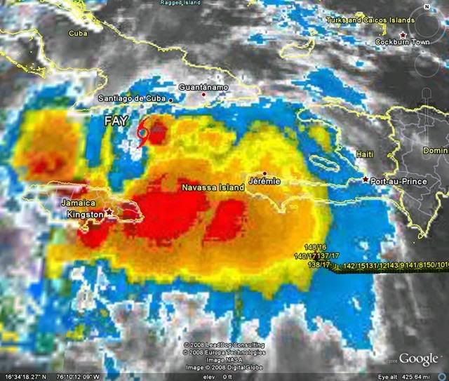
I can't think of any other possibilities with what you see there moving WSW. You would think that any swirl rotating around the LLC in that position would be moving ESE or East from that location as it rotated around the true LLC to its north.
I believe that to be our true LLC, Recon shall prove us right or wrong.
I believe that to be our true LLC, Recon shall prove us right or wrong.
0 likes
-
Dean4Storms
- S2K Supporter
- Posts: 6358
- Age: 63
- Joined: Sun Aug 31, 2003 1:01 pm
- Location: Miramar Bch. FL
Re: Re:
vbhoutex wrote:Dean4Storms wrote:Zoom in here and speed up the animation, you'll see what Delta and I have been getting at.
http://www.ssd.noaa.gov/goes/flt/t1/loop-ir2.html
It is lower level clouds, note the light gray colors.
Looking at that loop I see the LLCC right where NHC says it is. As Marshall says we will know shortly. I looked at some earlier(a few pages back)posted loops by Dean, etc. and what I think some are alluding to may have been an outflow boundary, which I note has now disappeared.
That doesn't look like an outflow boundary to me at roughly 18.8n 76.6w
0 likes


Re: ATL: Tropical Storm Fay South of Cuba
The CMC seems to have changed a bit too, with a landfall further south in FL, then bringing it up the W Coast for a short time, and then it cuts across the state back into the Atlantic and looks as if it will track into SC
0 likes
-
Extremeweatherguy

- Category 5
- Posts: 11095
- Joined: Mon Oct 10, 2005 8:13 pm
- Location: Florida
-
senorpepr

- Military Met/Moderator

- Posts: 12542
- Age: 43
- Joined: Fri Aug 22, 2003 9:22 pm
- Location: Mackenbach, Germany
- Contact:
Re:
fact789 wrote:Thanks! One comment...can you bring the legends above the streamlines?
The only problem with that is, since the legend and the radar image are tied together, if I place the legend above the streamlines, the radar will block out the streamlines.
The legend really doesn't provide any additive information anyway, beyond what radar sites are used (BYX and AMX), what product (248nm 0.5° BREF), and what time (most current).
0 likes
Re:
HURAKAN wrote:
BOOM! Just south of Cuba.
coincides exactly with the radar link ed posted on 292 (which shows explosive t-storms on NE side of likely LLC)
Dean you gotta admit this looks like it makes sense. the IR2 no longer shows much turning in the area i pointed out before
0 likes

-
Dean4Storms
- S2K Supporter
- Posts: 6358
- Age: 63
- Joined: Sun Aug 31, 2003 1:01 pm
- Location: Miramar Bch. FL
Re: Re:
cpdaman wrote:HURAKAN wrote:
BOOM! Just south of Cuba.
coincides exactly with the radar link ed posted on 292 (which shows explosive t-storms on NE side of likely LLC)
Dean you gotta admit this looks like it makes sense. the IR2 no longer shows much turning in the area i pointed out before
I just know I see a LLC down there near where Delta pointed out in the IR2 and it is also just at the NW edge of that deep convection just east of Jamaica. I guess we will have to wait on Recon to know for sure. If we are wrong, we are wrong, but it looks suspicious nonetheless.
0 likes
-
Dean4Storms
- S2K Supporter
- Posts: 6358
- Age: 63
- Joined: Sun Aug 31, 2003 1:01 pm
- Location: Miramar Bch. FL
cpdaman.....
Zoom in just north of eastern Jamaica and speed up the animation and tell me what you see there........
http://www.ssd.noaa.gov/goes/flt/t1/loop-ir2.html
Zoom in just north of eastern Jamaica and speed up the animation and tell me what you see there........
http://www.ssd.noaa.gov/goes/flt/t1/loop-ir2.html
0 likes
-
Dean4Storms
- S2K Supporter
- Posts: 6358
- Age: 63
- Joined: Sun Aug 31, 2003 1:01 pm
- Location: Miramar Bch. FL
I see an outflow coming out of the convection to the north where they say the LLC should be even on Visible here......
Once again zoom in and speed it up........
http://www.ssd.noaa.gov/goes/flt/t1/loop-vis.html
Once again zoom in and speed it up........
http://www.ssd.noaa.gov/goes/flt/t1/loop-vis.html
0 likes
Who is online
Users browsing this forum: No registered users and 113 guests