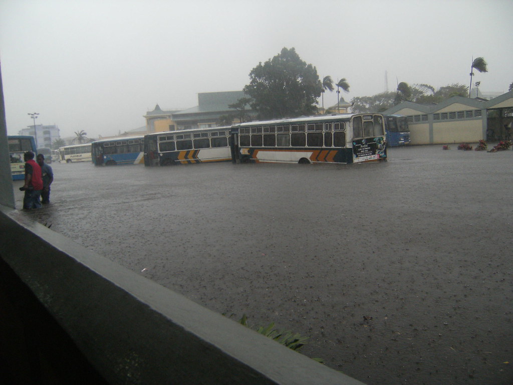
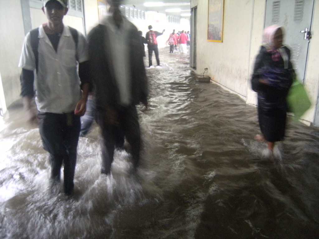
I confirm it's been raining torrentially past 6 hours.
Gusts of winds easily reached >90km/h under rain from wat i observed.
SW Indian Ocean: Tropical Depression ex.Lola (TC 25S)
Moderator: S2k Moderators
-
gigabyte89
- Tropical Low

- Posts: 45
- Age: 36
- Joined: Fri Feb 22, 2008 9:10 am
- Location: Mauritius
-
gigabyte89
- Tropical Low
- Posts: 45
- Age: 36
- Joined: Fri Feb 22, 2008 9:10 am
- Location: Mauritius

-
HurricaneRobert
- Category 3

- Posts: 812
- Joined: Fri May 18, 2007 9:31 pm
Re: SW Indian Ocean: Tropical Depression ex.Lola (TC 25S)

Looks like a pretty good tropical storm, but jtwc is still calling it a depression.
0 likes
Re: SW Indian Ocean: Tropical Depression ex.Lola (TC 25S)
damn the rain cannot just stop here in Mauritius!
0 likes
-
gigabyte89
- Tropical Low
- Posts: 45
- Age: 36
- Joined: Fri Feb 22, 2008 9:10 am
- Location: Mauritius
Re: SW Indian Ocean: Tropical Depression ex.Lola (TC 25S)
Fadil wrote:damn the rain cannot just stop here in Mauritius!
Been raining quasi non-stop for 12 hours with heavy fog and windy too!
I wonder if there will be school today!
0 likes
-
gigabyte89
- Tropical Low
- Posts: 45
- Age: 36
- Joined: Fri Feb 22, 2008 9:10 am
- Location: Mauritius


-
gigabyte89
- Tropical Low
- Posts: 45
- Age: 36
- Joined: Fri Feb 22, 2008 9:10 am
- Location: Mauritius

-
gigabyte89
- Tropical Low
- Posts: 45
- Age: 36
- Joined: Fri Feb 22, 2008 9:10 am
- Location: Mauritius

2008 26 MAR 0800z: TD 25S/LOLA : South Indian Ocean, Mascarenes islands area.
Centre loc: near 17.5s and 56.6e at 00z(JTWC)
near 16.9s and 56.9e at 00z(MTOTEC)
MOVEMENT PAST SIX HOURS(06z) SSE 05KTS
Max winds(1mn): 30kts(T2.0/00z/Jtwc&Mtotec)
CATEGORY(Australian): below CAT1
Satellite Imagery:
Met7(57.5e)hres eir mdnaa 00z ,Raoul MAUJEAN.
MY REMARKS:
most active convection still over open water.
Cheers
Patrick HOAREAU.
0 likes
-
gigabyte89
- Tropical Low
- Posts: 45
- Age: 36
- Joined: Fri Feb 22, 2008 9:10 am
- Location: Mauritius


-
gigabyte89
- Tropical Low
- Posts: 45
- Age: 36
- Joined: Fri Feb 22, 2008 9:10 am
- Location: Mauritius
Missing and drown persons as well as vehicles carried away with people are being reported actually... I'll let u informed.
A child as well as his father and mother (trying to rescue him) reported drowned.
2-3 persons carried away by currents, unable to make distinction between river and roads.
Reports of incidents actually flying in over the radio...
A child as well as his father and mother (trying to rescue him) reported drowned.
2-3 persons carried away by currents, unable to make distinction between river and roads.
Reports of incidents actually flying in over the radio...
0 likes
-
gigabyte89
- Tropical Low
- Posts: 45
- Age: 36
- Joined: Fri Feb 22, 2008 9:10 am
- Location: Mauritius
-
gigabyte89
- Tropical Low
- Posts: 45
- Age: 36
- Joined: Fri Feb 22, 2008 9:10 am
- Location: Mauritius
** WTIO21 FMEE 261234 ***
METEO-FRANCE/CENTRE DES CYCLONES TROPICAUX DE LA REUNION
BMS MARINE LE 26/03/2008 A 1200 UTC.
NUMERO: 023/14 (SUD-OUEST DE L'OCEAN INDIEN)
VITESSES DU VENT MOYEN SUR 10 MINUTES EN NOEUDS (KT)
(LES RAFALES SUR MER PEUVENT EXCEDER D'ENVIRON 40% LA VALEUR DU VENT
MOYEN).
PRESSION MINIMALE AU NIVEAU DE LA MER EN HECTOPASCALS (HPA)
(VALEUR INDICATIVE).
AVERTISSEMENT
DEBUT DE VALIDITE: MERCREDI 26/03/2008 A 1200 UTC.
PHENOMENE: ZONE PERTURBEE 14 (EX-LOLA) 1001 HPA
POSITION: INDETERMINE A 1200 UTC
DEPLACEMENT: SUD-SUD-EST 5 KT
ZONES MENACEES:
FORTE CONVECTION A PROXIMITE EST DE MAURICE ENTRE 19S ET 22S ET ENTRE 58E
ET 61E SE DECALANT VERS LE SUD-EST
VASTE CIRCULATION DEPRESSIONNAIRE A 15/20 KT ET MER AGITEE A FORTE AU SEIN DU TRIANGLE MAURICE, SAINT-BRANDON, TROMELIN ATTEIGNANT TRES LOCALEMENT LE GRAND FRAIS 30 KT ET MER FORTE SOUS LA ZONE DE FORTE
CONVECTION.
FORTES RAFALES SOUS GRAINS.
PREVISIONS: POSITION ET INTENSITE PREVUES:
A 12H POUR LE 27/03/2008 A 00 UTC:
DISSIPE.
A 24H POUR LE 27/03/2008 A 12 UTC:
DISSIPE.
INDICATIONS COMPLEMENTAIRES:
LES DERNIERES IMAGES VISIBLE MONTRENT UN SYSTEME TRES DESTRUCTURE AVEC EXISTENCE DE PLUSIEURS CENTRES DE BASSES COUCHES. DEUX CENTRES DE BASSES COUCHES SONT CLAIREMENT VISIBLES, L'UN VERS 16.3S ET 57.3E ET L'AUTRE VERS 17.7S ET 56.5E. UN TROISIEME CENTRE POTENTIEL MAIS NON CLAIREMENT
IDENTIFIE POURRAIT SE SITUER VERS 18.3S ET 58.9E. EN CONSEQUENCE, CETTE PERTURBATION EST DECLASSEE EN ZONE PERTURBE ET CECI EST LE DERNIER BULLETIN SUR CE SYSTEME.
0 likes


-
HurricaneRobert
- Category 3
- Posts: 812
- Joined: Fri May 18, 2007 9:31 pm
Re: SW Indian Ocean: Tropical Depression ex.Lola (TC 25S)
Is there separate low-level and mid-level circulations (not stacked)? That's some really nice outflow, so I think the winds could be higher than what they're saying.
0 likes
Who is online
Users browsing this forum: No registered users and 30 guests