We here can expect a wet weekend if all pans out as forecast.
WEATHER SUMMARY FOR PUERTO RICO
NATIONAL WEATHER SERVICE SAN JUAN PR
348 PM AST FRI SEP 19 2008
PARTLY CLOUDY SKIES PREVAILED ACROSS PUERTO RICO...CULEBRA...AND
VIEQUES THIS AFTERNOON. SCATTERED SHOWERS AND THUNDERSTORMS
DEVELOPED ACROSS THE SOUTH AND SOUTHWEST SECTIONS OF PUERTO RICO.
THIS ACTIVITY WAS PRODUCING HEAVY RAIN ACROSS YAUCO...CABO ROJO...AND
SABANA GRANDE. AN URBAN AND SMALL STREAM FLOOD ADVISORY WAS ISSUED FOR
THESE AREAS. THE MAXIMUM TEMPERATURES IN SOME CITIES IN PUERTO
RICO WERE AS FOLLOWS...PONCE 91 DEGREES...DEGREES...MAYAGUEZ 91
DEGREES...AND IN SAN JUAN IT WAS 89 DEGREES. WINDS WERE MAINLY FROM
THE EAST NORTHEAST AT 10 TO 15 MPH EXCEPT FOR SEA BREEZE
VARIATIONS AT COASTAL LOCATIONS.
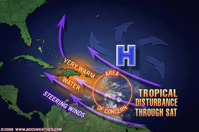
AN AREA OF DISTURBED WEATHER ASSOCIATED WITH A TROPICAL WAVE
CROSSING THE LESSER ANTILLES AND ENTERING THE EASTERN CARIBBEAN
THIS AFTERNOON..IS PRODUCING CONSIDERABLE CLOUDINESS...SHOWERS
AND THUNDERSTORMS ACROSS THE LEEWARD AND WINDWARD ISLANDS. SOME
ADDITIONAL ORGANIZATION OF THIS SYSTEM IS POSSIBLE OVER THE NEXT
COUPLE OF DAYS AS IT MOVES SLOWLY ACROSS THE EASTERN CARIBBEAN
SEA. THIS FEATURE WILL COMBINE WITH FAVORABLE UPPER LEVEL
CONDITIONS...TO PRODUCE SHOWERS AND THUNDERSTORMS WITH LOCALLY
GUSTY WINDS ACROSS THE LOCAL ISLANDS SATURDAY AND SUNDAY. A WET
WEATHER PATTERN IS FORECAST TO PREVAIL ACROSS THE REGION UNTIL AT
LEAST SUNDAY.
http://www.srh.noaa.gov/productview.php ... &version=0
AREA FORECAST DISCUSSION
NATIONAL WEATHER SERVICE SAN JUAN PR
400 PM AST FRI SEP 19 2008
.DISCUSSION...AN AREA OF DISTURBED WEATHER ASSOCIATED WITH A
TROPICAL WAVE...LOCATED OVER THE SOUTHEAST CARIBBEAN AND
EXTENDING EAST ACROSS THE LESSER ANTILLES LATE THIS AFTERNOON...
WILL CONTINUE MOVING SLOWLY WEST NORTHWEST TONIGHT THROUGH THE
UPCOMING WEEKEND...PASSING ACROSS OR JUST SOUTH OF THE LOCAL AREA
LATE SATURDAY THROUGH SUNDAY. ALTHOUGH THE TIMING HAS BEEN PUSHED
BACK SLIGHTLY...WE STILL EXPECT THAT THIS FEATURE AND ITS
ASSOCIATED MOISTURE WILL COMBINE WITH FAVORABLE UPPER LEVEL
CONDITIONS...TONIGHT THROUGH AT LEAST SATURDAY NIGHT OR SUNDAY...TO
PRODUCE INCREASING SHOWERS AND THUNDERSTORMS WITH LOCALLY GUSTY
WINDS ACROSS THE LOCAL ISLANDS. BASED ON LATEST MODEL PROJECTIONS...
IT STILL APPEARS THAT DEEP TROPICAL MOISTURE WILL BE ADVECTED
INTO/ACROSS THE LOCAL ISLANDS LATE TONIGHT/EARLY SATURDAY THROUGH
AT LEAST SATURDAY NIGHT OR SUNDAY...AS SYSTEM MOVES SLOWLY WEST
NORTHWEST. INITIALLY HOSTILE UPPER LEVEL WINDS (FOR DEVELOPMENT)
MAY GRADUALLY BECOME MORE FAVORABLE OVER THE NEXT DAY OR SO AND WE
WILL STILL NEED TO WATCH THIS SYSTEM CLOSELY. IRRESPECTIVE OF ANY
DEVELOPMENT...THE COMBINATION OF AFOREMENTIONED SLOW MOVING
DISTURBANCE...DEEP TROPICAL MOISTURE...INCREASINGLY FAVORABLE
UPPER LEVEL CONDITIONS AND LOCAL EFFECTS SHOULD RESULT IN AN
EXTENDED PERIOD OF UNSETTLED WEATHER...WITH SIGNIFICANT AMOUNTS OF
CLOUDINESS...SHOWERS AND THUNDERSTORMS ACROSS THE FA.
IN ADDITION...THIS SYSTEM STILL HAS THE POTENTIAL TO PRODUCE AT
LEAST AREAS OF HEAVY RAINFALL ACROSS THE LOCAL ISLANDS WHICH COULD
IN TURN RESULT IN FLASH AND/OR RIVER FLOODING. THUS...ALL LOCAL
RESIDENTS AND VISITORS SHOULD CONTINUE TO CLOSELY MONITOR THIS
SYSTEM DURING THE NEXT COUPLE OF DAYS. IN ADDITION...PEOPLE ARE
REMINDED THAT IT DOES NOT HAVE TO BE RAINING IN YOUR EXACT
LOCATION FOR DANGEROUS WATER SURGES TO OCCUR IN LOCAL RIVERS AND
STREAMS. PLEASE USE EXTRA CAUTION IF VENTURING INTO ANY LOCAL
RIVERS OR STREAMS DURING THE NEXT FEW DAYS.
http://www.srh.noaa.gov/fwd/productview ... &version=0


