ATL: INVEST 96L - Discussion
Moderator: S2k Moderators
-
Blown Away

- S2K Supporter

- Posts: 10253
- Joined: Wed May 26, 2004 6:17 am
Re: ATL: INVEST 96L - Discussion
gatorcane wrote:Blown_away wrote::uarrow: If 96L maintains its convection I expect back to "Code Orange" sometime today.
Not only that if 12Z and 18Z GFDL and HWRF runs are showing tropical development, I bet NHC puts it back at code orange at the next advisory. Currently the GFDL is bullish on development but the HWRF is not quite as bullish.
The GFDL & HWRF were bullish with Paloma when the others were not. GFDL kept showing Paloma as a major cane days before she became one. IMO, 96L is looking good and it would not surprise me if this became a named system down the road.
0 likes


-
wxman57

- Moderator-Pro Met

- Posts: 23175
- Age: 68
- Joined: Sat Jun 21, 2003 8:06 pm
- Location: Houston, TX (southwest)
Re: ATL: INVEST 96L - Discussion
Convection is diminishing. Shear is too high, and there is no evidence of any rotation at the surface or aloft. Chances of development remain very low. You have to remember that the models have to initialize a vortex - a rotation. But there is no vortex, so they're going to be too bullish on development. And the GFDL doesn't detect shear well.
0 likes
NHC might have to add the system in the Atlantic as another invest:
http://www.goes.noaa.gov/browsh.html
http://www.goes.noaa.gov/browsh.html
0 likes
-
Ed Mahmoud
Re:
Frank2 wrote:NHC might have to add the system in the Atlantic as another invest:
http://www.goes.noaa.gov/browsh.html
Look at the satellite loop, and it is pretty obvious the big system East of Bermuda is frontal.
We should be more excited about the possibility of winter weather affecting Northwest Texas on Sunday...
0 likes
-
wxman57
- Moderator-Pro Met
- Posts: 23175
- Age: 68
- Joined: Sat Jun 21, 2003 8:06 pm
- Location: Houston, TX (southwest)
Re: ATL: INVEST 96L - Discussion
I think that 96L is quite possibly the weakest invest of the entire 2008 season. Really not much of any chance of development.
0 likes
-
cycloneye

- Admin

- Posts: 149727
- Age: 69
- Joined: Thu Oct 10, 2002 10:54 am
- Location: San Juan, Puerto Rico
Re: ATL: INVEST 96L - Discussion
ABNT20 KNHC 242336
TWOAT
TROPICAL WEATHER OUTLOOK
NWS TPC/NATIONAL HURRICANE CENTER MIAMI FL
700 PM EST MON NOV 24 2008
FOR THE NORTH ATLANTIC...CARIBBEAN SEA AND THE GULF OF MEXICO...
A LARGE AREA OF DISTURBED WEATHER PERSISTS OVER THE SOUTHWESTERN
CARIBBEAN SEA IN ASSOCIATION WITH A BROAD AREA OF LOW PRESSURE.
THERE ARE NO SIGNS OF TROPICAL CYCLONE FORMATION...AND ANY FURTHER
DEVELOPMENT IS EXPECTED TO BE SLOW TO OCCUR. AS THIS SYSTEM DRIFTS
SLOWLY WESTWARD...IT WILL LIKELY PRODUCE HEAVY RAINS AND LOCALIZED
FLOODING OVER PORTIONS OF PANAMA...COSTA RICA...AND NICARAGUA
DURING THE NEXT COUPLE OF DAYS.
ELSEWHERE...TROPICAL CYCLONE FORMATION IS NOT EXPECTED DURING THE
NEXT 48 HOURS.
$$
FORECASTER BRENNAN/BERG
0 likes

Re: ATL: INVEST 96L - Discussion
wxman57 wrote:But there is no vortex, so they're going to be too bullish on development. And the GFDL doesn't detect shear well.
If the GFDL model couldn't detect shear well, then no one would use it and it wouldn't have been invented because then it would be useless in the tropics.
0 likes
-
jconsor
- Professional-Met

- Posts: 581
- Joined: Mon Jun 30, 2008 9:31 pm
- Location: Jerusalem, Israel
- Contact:
Re: ATL: INVEST 96L - Discussion
wxman57 wrote:I think that 96L is quite possibly the weakest invest of the entire 2008 season. Really not much of any chance of development.
Nah, 95L about 10 days ago beats it hands down
0 likes
-
DESTRUCTION5

- Category 5

- Posts: 4430
- Age: 44
- Joined: Wed Sep 03, 2003 11:25 am
- Location: Stuart, FL
Re: ATL: INVEST 96L - Discussion
jconsor wrote:wxman57 wrote:I think that 96L is quite possibly the weakest invest of the entire 2008 season. Really not much of any chance of development.
Nah, 95L about 10 days ago beats it hands downIt was an invest for about 12 hours when a small blob of convection blew up, then died, around an upper low north of Puerto Rico.
I think there was one in June-July that crashed into trinidad as a puffy cirrus...
0 likes
-
Derek Ortt
Re: ATL: INVEST 96L - Discussion
Cyclenall wrote:wxman57 wrote:But there is no vortex, so they're going to be too bullish on development. And the GFDL doesn't detect shear well.
If the GFDL model couldn't detect shear well, then no one would use it and it wouldn't have been invented because then it would be useless in the tropics.
it is well known that the GFDL ahs trouble with shear. That is because the grid points are too large to resolve convection. Therefore, the convection is parameterized. Models with parameterized convection are far more shear resistent than "real" models
0 likes
-
gatorcane

- S2K Supporter
- Posts: 23708
- Age: 48
- Joined: Sun Mar 13, 2005 3:54 pm
- Location: Boca Raton, FL
Re: ATL: INVEST 96L - Discussion
jconsor wrote:wxman57 wrote:I think that 96L is quite possibly the weakest invest of the entire 2008 season. Really not much of any chance of development.
Nah, 95L about 10 days ago beats it hands down
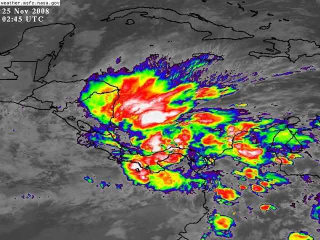
Wxman you are joking right? If convection just poofs tonight I agree but looking at the SAT presentation tonight it is rather impressive, albeit moderately sheared. I can think of several invests in 2008 that have been more pathetic looking than this.
If it moves into Central America its not going to develop but if it manages to stay over water, its got a chance. It may be the EPAC where it develops or the SW Carib -- too early to say.

0 likes
-
wxman57
- Moderator-Pro Met
- Posts: 23175
- Age: 68
- Joined: Sat Jun 21, 2003 8:06 pm
- Location: Houston, TX (southwest)
Re: ATL: INVEST 96L - Discussion
gatorcane wrote:
Wxman you are joking right? If convection just poofs tonight I agree but looking at the SAT presentation tonight it is rather impressive, albeit moderately sheared. I can think of several invests in 2008 that have been more pathetic looking than this.
If it moves into Central America its not going to develop but if it manages to stay over water, its got a chance. It may be the EPAC where it develops or the SW Carib -- too early to say.
No, not joking. Most invests have at least a hint of rotation and thunderstorms that are better organized than 96L. There's not much to 96L Just disorganized, scattered convection in moderate shear. It doesn't have much of a chance of developing, and the NHC acknowledges that in its discussions.
0 likes
-
gatorcane
- S2K Supporter
- Posts: 23708
- Age: 48
- Joined: Sun Mar 13, 2005 3:54 pm
- Location: Boca Raton, FL
Re: ATL: INVEST 96L - Discussion
Wxman, if you look at 2008 systems I can think of several that were badly sheared for several days, and then seized the opportunity as soon as shear relaxed enough. Omar is one good example. It was a sheared mess just east of the Leewards but it maintained persistent, intense convection --- then BOOM. It took off.
This one is quite a tenacious area of convection that is definitely being persistent. I can even see a subtle broad rotation over the area this evening. It certainly deserves invest status to me. Models are generally taking it into Central America or killing it but, one must respect the GFDL and it begins to drift it off to the NE then NW into Nicaragua (probably because it may feel the trough passing by to the north but the trough doesn't quite scoop it up). Note also the ECMWF develops a weak tropical system now as well but keeps it in the extreme SW Caribbean before killing it off.
Still, its late November and its almost Thanksgiving so this shouldn't even be our concentration now anyway. This season seems to be dragging to a close, but not fast enough if you ask me. I'm just ready to do alot of eating for Turkey Day
0 likes
Re: ATL: INVEST 96L - Discussion
Derek Ortt wrote:it is well known that the GFDL ahs trouble with shear. That is because the grid points are too large to resolve convection. Therefore, the convection is parameterized. Models with parameterized convection are far more shear resistent than "real" models
This is the first I've heard of this, it's not well known. You would think it would be the other way around.
0 likes
-
Derek Ortt
Re: ATL: INVEST 96L - Discussion
Cyclenall wrote:Derek Ortt wrote:it is well known that the GFDL ahs trouble with shear. That is because the grid points are too large to resolve convection. Therefore, the convection is parameterized. Models with parameterized convection are far more shear resistent than "real" models
This is the first I've heard of this, it's not well known. You would think it would be the other way around.
convective parameterization is well known in the community. I even went over a basic parameterization when giving a lecture to the undergrads in their dynamics class a couple of weeks ago. See chapter 11 of the Holton text book
0 likes
-
HURAKAN

- Professional-Met
- Posts: 46084
- Age: 39
- Joined: Thu May 20, 2004 4:34 pm
- Location: Key West, FL
- Contact:
496
ABNT20 KNHC 251133
TWOAT
TROPICAL WEATHER OUTLOOK
NWS TPC/NATIONAL HURRICANE CENTER MIAMI FL
700 AM EST TUE NOV 25 2008
FOR THE NORTH ATLANTIC...CARIBBEAN SEA AND THE GULF OF MEXICO...
A LARGE AREA OF DISTURBED WEATHER CONTINUES OVER THE SOUTHWESTERN
CARIBBEAN SEA IN ASSOCIATION WITH A BROAD AREA OF LOW PRESSURE. THIS
SYSTEM REMAINS POORLY ORGANIZED AND FURTHER DEVELOPMENT...IF ANY...
IS EXPECTED TO BE SLOW TO OCCUR. HEAVY RAINS AND LOCALIZED FLOODING
OVER PORTIONS OF PANAMA...COSTA RICA...NICARAGUA...AND EASTERN
HONDURAS ARE LIKELY DURING THE NEXT COUPLE OF DAYS AS THE SYSTEM
DRIFTS WESTWARD.
ELSEWHERE...TROPICAL CYCLONE FORMATION IS NOT EXPECTED DURING THE
NEXT 48 HOURS.
$$
FORECASTER AVILA
0 likes
Who is online
Users browsing this forum: No registered users and 38 guests