ATL: PALOMA - Tropical Depression - Discussion

Moderator: S2k Moderators

Message
Author
User avatar
DESTRUCTION5
Category 5
Category 5
Posts: 4391
Age: 42
Joined: Wed Sep 03, 2003 11:25 am
Location: Stuart, FL

Re:

#601 Postby DESTRUCTION5 » Sat Nov 08, 2008 10:06 am

HURAKAN wrote:440
WTNT42 KNHC 081456
TCDAT2
HURRICANE PALOMA DISCUSSION NUMBER 13
NWS TPC/NATIONAL HURRICANE CENTER MIAMI FL AL172008
1000 AM EST SAT NOV 08 2008

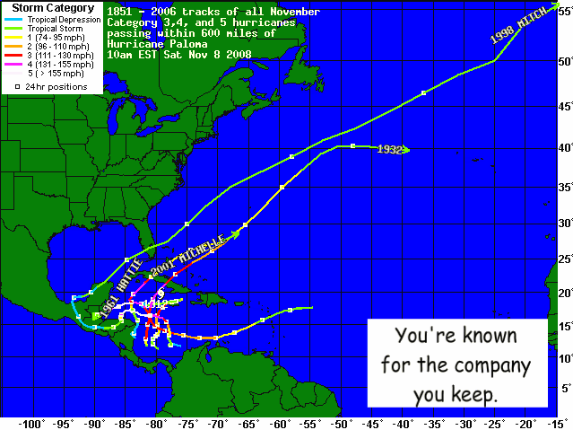
PALOMA IS TIED FOR THE SECOND STRONGEST ATLANTIC HURRICANE EVER
NOTED IN NOVEMBER...THE STRONGEST BEING LENNY IN 1999.

FORECASTER BLAKE


:eek: :eek: :eek:

Another record bites the dust....
0 likes   

User avatar
HURAKAN
Professional-Met
Professional-Met
Posts: 46086
Age: 37
Joined: Thu May 20, 2004 4:34 pm
Location: Key West, FL
Contact:

#602 Postby HURAKAN » Sat Nov 08, 2008 10:13 am

Image
0 likes   

User avatar
AdamFirst
S2K Supporter
S2K Supporter
Posts: 2488
Age: 35
Joined: Thu Aug 14, 2008 10:54 am
Location: Port Saint Lucie, FL

#603 Postby AdamFirst » Sat Nov 08, 2008 10:24 am

What are the shear forecasts? Anybody have a link to those?

Local mets mention "weak cold front"...I assume that's the trough full of the shear.
0 likes   

User avatar
canetracker
S2K Supporter
S2K Supporter
Posts: 746
Age: 61
Joined: Wed Jul 27, 2005 8:49 pm
Location: Suburbia New Orleans...Harahan, LA

Re:

#604 Postby canetracker » Sat Nov 08, 2008 10:29 am

AdamFirst wrote:What are the shear forecasts? Anybody have a link to those?

Local mets mention "weak cold front"...I assume that's the trough full of the shear.


Shear tendency looks pretty hostile
http://cimss.ssec.wisc.edu/tropic2/real-time/windmain.php?&basin=atlantic&sat=wg8&prod=sht&zoom=&time=
0 likes   

User avatar
wxman57
Moderator-Pro Met
Moderator-Pro Met
Posts: 22506
Age: 66
Joined: Sat Jun 21, 2003 8:06 pm
Location: Houston, TX (southwest)

Re: ATL: PALOMA - Hurricane - Discussion

#605 Postby wxman57 » Sat Nov 08, 2008 10:37 am

Folks, there won't be much left of Paloma to regenerate after 72 hours, maybe less. The wind shear across the Bahamas is quite hostile now and it won't get any better over the next week. Upper level winds are screaming out of the west, lower level out of the NE-E, mid-level from the northwest. It can't get much more hostile than that for TC formation. It's quite likely Paloma will have dissipated by Monday night or Tuesday with the last advisory having been written by then.

Take a look at projected upper-level wind flow across the region by Tuesday (and it's no better before or after):

Image
0 likes   

User avatar
Blown Away
S2K Supporter
S2K Supporter
Posts: 9874
Joined: Wed May 26, 2004 6:17 am

Re: ATL: PALOMA - Hurricane - Discussion

#606 Postby Blown Away » Sat Nov 08, 2008 10:55 am

cycloneye wrote:Those in Florida,dont freak out when you see the below graphic as by then it will be a remnant low.

Image


Are you implying that Floridians have a history of over reacting to tropical systems? Watch out or I will have to sick Gatorcane on you! :D
0 likes   

jinftl
Category 5
Category 5
Posts: 4312
Joined: Tue Aug 31, 2004 4:47 pm
Location: fort lauderdale, fl

Re: ATL: PALOMA - Hurricane - Discussion

#607 Postby jinftl » Sat Nov 08, 2008 11:00 am

NHC releases data on forecast storm strength each advisory....and they do so in terms of probability. Certain outcomes are more probable than others based on their analysis of the data and resulting forecast. Very rarely do you hear the NHC take the 'definitive' tones like 'no chance', 'all clear', etc.

Forecasts are just that...and as we have seen with the initial thinking that Paloma would jet out to the open atlantic, that probably won't happen. Just as a front was supposed to sweep through the entire state of florida this weekend, now it is forecast to dissipate over the central part of the state.

As of 10am update....the NHC probability of Paloma's strength in 12, 24, 36, 48, 72, 96, and 120 hours are shown below....of note, they have the probabilty that Paloma will have dissipated in 96 hours is 41% and in 120 hours is 49%. Watch the trend with this data in later advisories today.


HURRICANE PALOMA WIND SPEED PROBABILITIES NUMBER 13
NWS TPC/NATIONAL HURRICANE CENTER MIAMI FL AL172008
1500 UTC SAT NOV 08 2008

- - - MAXIMUM WIND SPEED (INTENSITY) PROBABILITIES - - -

VALID TIME 00Z SUN 12Z SUN 00Z MON 12Z MON 12Z TUE 12Z WED 12Z THU
FORECAST HOUR 12 24 36 48 72 96 120
- - - - - - - - - - - - - - - - - - - - - - - - - - - - - - - - - -
DISSIPATED X X 3 12 33 41 49
TROP DEPRESSION X X 15 30 35 32 27
TROPICAL STORM X 6 63 50 29 24 21
HURRICANE 99 94 19 8 4 3 2
0 likes   

User avatar
cycloneye
Admin
Admin
Posts: 139602
Age: 67
Joined: Thu Oct 10, 2002 10:54 am
Location: San Juan, Puerto Rico

Re: ATL: PALOMA - Hurricane - Discussion

#608 Postby cycloneye » Sat Nov 08, 2008 11:22 am

Good news from Cayman Brac.Check it out in the thread at the top of forum.

viewtopic.php?f=59&t=103838&p=1847489#p1847489
0 likes   

Frank2
Category 5
Category 5
Posts: 4061
Joined: Mon Jul 25, 2005 12:47 pm

#609 Postby Frank2 » Sat Nov 08, 2008 11:29 am

Good (late morning) to all:

It appears that Paloma is either weakening ATTM or undergoing an ERC, but, I'll guess that it's now begun to weaken, per the warming of the cloud tops on IR and the eye now being cloud-filled on the VIS:

http://www.ssd.noaa.gov/goes/flt/t1/loop-avn.html

we are very greatful for the timing of the strong trough to our west - had it not been for that, South Florida could have seen another Wilma event - or worse...

Frank
0 likes   

User avatar
wxman57
Moderator-Pro Met
Moderator-Pro Met
Posts: 22506
Age: 66
Joined: Sat Jun 21, 2003 8:06 pm
Location: Houston, TX (southwest)

Re: ATL: PALOMA - Hurricane - Discussion

#610 Postby wxman57 » Sat Nov 08, 2008 11:33 am

Definitely looks like Paloma is weakening. Shear has hit its western side and outflow has been disrupted. Could be severely weakened by the time it reaches Cuba, maybe to Cat 1-2. Let's hope so.
0 likes   

tolakram
Admin
Admin
Posts: 19182
Age: 60
Joined: Sun Aug 27, 2006 8:23 pm
Location: Florence, KY (name is Mark)

Re: ATL: PALOMA - Hurricane - Discussion

#611 Postby tolakram » Sat Nov 08, 2008 11:37 am

It appears, from the closer visibles, that the top may be leaning or blowing off to the east.

Image
0 likes   

User avatar
Tampa Bay Hurricane
Category 5
Category 5
Posts: 5596
Age: 36
Joined: Fri Jul 22, 2005 7:54 pm
Location: St. Petersburg, FL

Re: ATL: PALOMA - Hurricane - Discussion

#612 Postby Tampa Bay Hurricane » Sat Nov 08, 2008 11:43 am

wxman57 wrote:Folks, there won't be much left of Paloma to regenerate after 72 hours, maybe less. The wind shear across the Bahamas is quite hostile now and it won't get any better over the next week. Upper level winds are screaming out of the west, lower level out of the NE-E, mid-level from the northwest. It can't get much more hostile than that for TC formation. It's quite likely Paloma will have dissipated by Monday night or Tuesday with the last advisory having been written by then.

Take a look at projected upper-level wind flow across the region by Tuesday (and it's no better before or after):

Image


My only worry is can shear take down a high end cat 4 that quickly? I can see shear weakening
it by 2 categories, and the mountains of Cuba an additional category, meaning a cat 1 reemerging,
i do not want this to reemerge as a hurricane, but I am simply concerned seeing the west bend at day 4/5.
0 likes   

User avatar
Just Joshing You
Category 2
Category 2
Posts: 512
Joined: Sat Nov 03, 2007 10:29 am
Location: Nova Scotia

Re: ATL: PALOMA - Hurricane - Discussion

#613 Postby Just Joshing You » Sat Nov 08, 2008 11:47 am

wxman57 wrote:Definitely looks like Paloma is weakening. Shear has hit its western side and outflow has been disrupted. Could be severely weakened by the time it reaches Cuba, maybe to Cat 1-2. Let's hope so.


NHC expects a Major Hurricane on landfall.
0 likes   

Derek Ortt

#614 Postby Derek Ortt » Sat Nov 08, 2008 11:48 am

I see no chance of a cat 1 in Cuba

I cannot see this weakening 3 categories in about 8 hours, which is about how long it has over the water. To a cat 3, likely. Maybe an upper 2 if we're lucky

What is also making the satellite worse is the concentric eyewall activity. No double wind maxima yet, so it is in the initial stages
0 likes   

Sanibel
Category 5
Category 5
Posts: 10348
Joined: Mon Aug 30, 2004 11:06 pm
Location: Offshore SW Florida

Re: ATL: PALOMA - Hurricane - Discussion

#615 Postby Sanibel » Sat Nov 08, 2008 11:53 am

Worst winds must have missed Cayman Brac on the west eyewall.
0 likes   

User avatar
wxman57
Moderator-Pro Met
Moderator-Pro Met
Posts: 22506
Age: 66
Joined: Sat Jun 21, 2003 8:06 pm
Location: Houston, TX (southwest)

Re: ATL: PALOMA - Hurricane - Discussion

#616 Postby wxman57 » Sat Nov 08, 2008 11:59 am

Just Joshing You wrote:
wxman57 wrote:Definitely looks like Paloma is weakening. Shear has hit its western side and outflow has been disrupted. Could be severely weakened by the time it reaches Cuba, maybe to Cat 1-2. Let's hope so.


NHC expects a Major Hurricane on landfall.


Yes, not a lot of time, but shear is increasing fast. I'm sure the NHC will leave it a Cat 3 at landfall even if evidence is saying otherwise - just to keep people warned that it may still be dangerous. Not a bad thing, they just don't like to downgrade landfalling hurricanes.
0 likes   

User avatar
cycloneye
Admin
Admin
Posts: 139602
Age: 67
Joined: Thu Oct 10, 2002 10:54 am
Location: San Juan, Puerto Rico

Re: ATL: PALOMA - Hurricane - Discussion

#617 Postby cycloneye » Sat Nov 08, 2008 12:00 pm

Image
0 likes   

User avatar
wxman57
Moderator-Pro Met
Moderator-Pro Met
Posts: 22506
Age: 66
Joined: Sat Jun 21, 2003 8:06 pm
Location: Houston, TX (southwest)

Re: ATL: PALOMA - Hurricane - Discussion

#618 Postby wxman57 » Sat Nov 08, 2008 12:01 pm

Tampa Bay Hurricane wrote:
My only worry is can shear take down a high end cat 4 that quickly? I can see shear weakening
it by 2 categories, and the mountains of Cuba an additional category, meaning a cat 1 reemerging,
i do not want this to reemerge as a hurricane, but I am simply concerned seeing the west bend at day 4/5.


The farther north it tracks, the greater the shear. If it was to reach the north coast of Cuba as a Cat 1 then it would still be weakening over water. There will be no opportunity to regain strength in the Bahamas with westerly winds at 50-60 kts aloft.
0 likes   

jlauderdal
S2K Supporter
S2K Supporter
Posts: 6813
Joined: Wed May 19, 2004 5:46 am
Location: NE Fort Lauderdale
Contact:

Re: ATL: PALOMA - Hurricane - Discussion

#619 Postby jlauderdal » Sat Nov 08, 2008 12:14 pm

wxman57 wrote:
Just Joshing You wrote:
wxman57 wrote:Definitely looks like Paloma is weakening. Shear has hit its western side and outflow has been disrupted. Could be severely weakened by the time it reaches Cuba, maybe to Cat 1-2. Let's hope so.


NHC expects a Major Hurricane on landfall.


Yes, not a lot of time, but shear is increasing fast. I'm sure the NHC will leave it a Cat 3 at landfall even if evidence is saying otherwise - just to keep people warned that it may still be dangerous. Not a bad thing, they just don't like to downgrade landfalling hurricanes.


so nhc has the leeway to assign categories regardless of the wind speed?
0 likes   

Derek Ortt

#620 Postby Derek Ortt » Sat Nov 08, 2008 12:27 pm

NHC does often keep the winds higher in landfalling situations, even if the data does not justify it

They kept Katrina as a 4 when the data showed it was a 3. The downgrade did not come until after the season
0 likes   


Return to “2008”

Who is online

Users browsing this forum: No registered users and 12 guests